Snappit logo
Snappit
Get App
Generic illustration, not a photograph of this venueIllustration
ParkAndalucía, Spain

Cabo de Gata-Níjar Natural Park

Cabo de Gata rewards a slower look.

About

Cabo de Gata rewards a slower look. The pale, open ground near Las Amoladeras can seem almost empty until you notice the rounded thorn bushes, the different shapes of drought-resistant leaves and the channels that carry water after heavy rain. Farther along the coast, dark volcanic rocks meet the sea; at the salt pans, shallow water creates a very different world for birds.

Start at the Las Amoladeras visitor centre on the AL-3115 between Retamar and Pujaire. Its exhibition connects the volcanic mountains, coastal steppe, dunes, salt pans and marine habitats, with human history woven through them. It is a useful first stop for families because you can choose a small theme to follow outdoors rather than trying to identify everything at once.

For a short introduction, pair the centre with the separate Las Amoladeras viewpoint nearby. Look across the scrub towards the rambla and the inland mountains. The large, cushion-like azufaifo bushes are especially interesting: their tangled branches shelter a whole community of life. Use the signed access to each place; do not turn the road between them into an improvised walking route.

The park continues well beyond this gateway, across parts of Almería, Níjar and Carboneras and into protected Mediterranean waters. The salt pans and Las Sirenas suit a western-coast outing. Los Escullos and La Isleta del Moro offer a separate short coastal walk; Rodalquilar adds a botanical garden and mining geology. Mesa Roldán, nearer Carboneras, makes sense as a northern visit of its own.

Choose one of these combinations and leave room to stop. A drive between scattered sights can consume the day, while a single quiet viewpoint may give you time to see wind moving through a palm, a bird feeding or layers of rock that tell very different stories. Don't forget to bring the Snappit nature identification app along to scan local species.

The coast has long supported fishing, grazing, small-scale farming, salt production and craftwork. Water wheels, cisterns, watchtowers and the former mining buildings at Rodalquilar help explain how people worked in a dry and exposed landscape. Las Amoladeras introduces these human stories alongside the habitats. The natural park was declared by a decree dated 23 December 1987. Its later international recognition includes UNESCO Biosphere Reserve and Global Geopark status. At Rodalquilar, the Casa de los Volcanes occupies a former gold-processing building associated with an operation that closed in 1966; today it gives a useful indoor introduction to the geology behind the scenery.


What to do here

Explore the Las Amoladeras exhibition, take a short look from its nearby viewpoint and choose one extra theme: birds at a public salt-pan observatory, volcanic scenery at Las Sirenas, or a separate coastal walk. Use Rodalquilar for a garden-and-geology day rather than trying to fit the whole park into one outing.

Seasonal info

Shade is limited on the open steppe and coastal paths. Strong wind can make exposed places uncomfortable or unsafe, and even a normally dry rambla can flood quickly. Check the forecast and current restrictions; avoid ravines, road underpasses and low crossings during heavy rain. Summer beach access and buses use separate seasonal arrangements.

Accessibility

Las Amoladeras is listed with physical, visual and hearing accessibility features, and its online exhibition includes sign-language videos. Ask staff about the parking-to-entrance route, accessible toilet and help available for your visit. Those features do not establish wheelchair access on the outdoor circuit, salt-pan approaches or cliff viewpoints. Assess each stop separately.

Don't miss

1

A clear introduction to five contrasting landscapes at Las Amoladeras

2

Rounded azufaifo scrub and open-country views from Las Amoladeras viewpoint

3

Quiet birdwatching from the public salt-pan observatories

4

Volcanic coastlines, fossil dunes and the raised fossil reef of Mesa Roldán

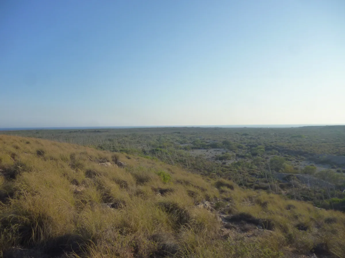
Dry grasses and low scrub spread across an open plain beneath a broad blue sky.

Scrubland seen from the Las Amoladeras viewpoint in July 2013.

Vistas mirador Las Amoladeras.jpg — Eduardo Milla / Wikimedia Commons / CC BY-SA 4.0 International · Creative Commons 1 · Creative Commons 2

Walks and routes

Las Amoladeras viewpoint: a short landscape stop

Allow 15–30 minutes at the viewpoint, separate from the centre visit. Take the signed turn from the AL-3115 near kilometre 6 and use its designated parking. Look for the contrast between introduced agaves, the dry rambla and the low, rounded azufaifo scrub beyond. There is plenty to notice here without setting out on a full walking circuit.

Ask staff about the current parking-to-viewpoint surface and whether the approach suits your wheelchair, walking aid or pushchair. Choose a stopping point that is comfortable for your group.

Las Amoladeras viewpoint: a short landscape stop

Las Amoladeras circuit: confirm the current route first

The older Junta leaflet describes a 6.5 km circular route from behind the visitor centre, with three hours of walking. It passes through coastal steppe and reaches open views over the surrounding landforms. This is the longer option, after staff have confirmed which signed line is in use; it is not part of the short centre-and-viewpoint visit.

The leaflet includes a road crossing and a bridge underpass, with natural ground along the walk. It is not presented as a wheelchair or pushchair route.

Las Amoladeras circuit: confirm the current route first

Escullos–Isleta del Moro: a short coastal walk

The official route starts north of Los Escullos beside Playa del Arco and ends at the Isleta del Moro viewpoint. The published distance is 1.997 km one way, with a 40-minute walking time and low difficulty. Returning the same way makes it about 4 km; allow 1½–2 hours with stops. Compare the shaped coastal rock with the distant volcanic domes of Los Frailes.

A short, low-difficulty route still needs walking shoes and a check of the natural surface. The endpoint’s accessibility marking does not extend to the whole trail.

Escullos–Isleta del Moro: a short coastal walk

Mesa Roldán: the northern geological option

The official linear trail is 1.9 km one way, with a one-hour walking time and low difficulty. Start at the signed trail off the Mesa Roldán approach from the Carboneras–Agua Amarga road. The flat-topped hill tells an unusual story: a fossil coral reef formed above a volcanic dome. Allow about 2–2½ hours for roughly 3.8 km out and back, with pauses.

This is an outdoor walk on a rising, exposed promontory. The low-difficulty classification is not an accessible-route certification; ask about terrain and approach if mobility is a concern.

Mesa Roldán: the northern geological option

Las Sirenas: view the cape from the official lookout

For a western-coast outing, approach via San Miguel de Cabo de Gata, La Almadraba and La Fabriquilla on the permitted lighthouse road. Allow 20–30 minutes to look at the rock pinnacles, lighthouse and cliffs from the established viewpoint. The so-called reef is the eroded remnant of an ancient volcanic vent.

Ask about the parking connection, any steps and the viewing surface before travelling with a wheelchair, walking aid or pushchair. A roadside location alone does not mean the whole approach will suit your group.

Las Sirenas: view the cape from the official lookout

A gentle first visit: 1–2 hours

Start with 45–60 minutes in Las Amoladeras, adjusting to attention spans and opening time. Ask staff about the immediate paths and current conditions, then make the separate 15–30-minute viewpoint stop. These are suggested allowances, with travel between the stops and a little flexibility included. Stop there if the heat or wind is tiring.

Half a day on the western side

After the centre and viewpoint, continue by the permitted road to a public salt-pan observatory. If the weather and parking allow, finish at Las Sirenas. Build in a meal or rest in a settlement and keep the cape visit to the lookout. This combination is meant to be unhurried; it does not include a beach walk or a drive through Vela Blanca.

A walking day, or a garden-and-museum day

Choose Escullos–Isleta del Moro for a roughly 4 km out-and-back coastal walk, then enjoy a village break. Alternatively, keep the day in Rodalquilar for El Albardinal and Casa de los Volcanes. Combining both is possible only if opening times, transport and your group’s energy leave enough margin; neither needs to be added to the western circuit.

A northern half day around Mesa Roldán

Give the 3.8 km out-and-back walk about 2–2½ hours with stops, then take a meal break in Carboneras or Agua Amarga. This is a separate approach to the park. Do not add a descent to Playa de los Muertos simply because it is nearby; that has different terrain, sea conditions and access arrangements.

Things to try

Five habitats, one small challenge

At the centre, let each person choose one habitat: mountain, steppe, dune, salt pan or sea. Outside, look for one clue that explains how life deals with heat, salt or wind. A leaf shape, a low-growing bush or a patch of shade is enough; you do not need to name every species.

Watch from a salt-pan observatory

Choose an open public observatory and settle quietly with binoculars. Compare the way birds feed: some probe, others sweep their bills, while flamingos filter in shallow water. Stay within the visitor area and let the birds choose the distance. One calm stop is more rewarding than repeatedly moving closer.

Read the coast without climbing on it

At Los Escullos, compare the pale fossil-dune forms with the darker volcanic scenery; at Mesa Roldán, think about coral growing on a former underwater high point. Use interpretation panels and views from the path. Do not scramble onto brittle formations or remove rock samples.

Spend a separate half day in Rodalquilar

Pair El Albardinal’s labelled plant collections with Casa de los Volcanes. The garden helps explain dry-climate adaptations; the museum connects volcanic processes with the history of gold mining. Confirm both opening schedules first and leave time to eat in the village.

Move the interpretation indoors

If it is safe to travel and the centre is open, use Las Amoladeras for the landscape story or Casa de los Volcanes for geology and mining. A botanical garden is outdoors, so El Albardinal is not a shelter-from-rain substitute. Confirm opening before changing your route.

Keep the day flexible

The Las Amoladeras virtual exhibition lets you explore the park’s themes from indoors, including sign-language material. In severe weather, postpone the exposed places rather than trying to rescue the plan with a cliff stop or a drive through a watercourse.

Wildlife and habitats

Mediterranean fan palm

Look for a low palm with leaves spreading like fans. It offers a useful contrast with the narrow leaves of many dry-country shrubs. Observe it from the path and leave every leaf and fruit in place.

Mastic

This evergreen shrub is part of the park’s dry scrub. Ask at the centre or use a field guide to learn its leaf pattern, then look for the same pattern outdoors without picking leaves.

Pied avocet

From a public observatory, watch for a black-and-white wader with an upturned bill. If one is feeding, notice the sideways sweep of its head. Binoculars help you enjoy the behaviour without moving closer.

Black-winged stilt

Look for the long-legged silhouette of a small black-and-white wader in shallow water. Stay in the public viewing area; never follow a bird into the salt pans or use its behaviour to look for a nest.

Neptune grass

The marine meadows are part of the park even on a land-based visit. Use the displays and interpretation to recognize long, ribbon-like seagrass leaves and understand how a flowering plant can live underwater. Leave washed-up natural material where it lies.

Watch what is there

Wildlife varies with season, water levels and the day’s conditions. These are species documented in the park, not a checklist to complete; enjoy what you find, keep your distance and never approach nests or use recorded calls.

Stories and discoveries

A thorn bush can be a small refuge

The broad azufaifo thickets around Las Amoladeras shelter other plants and animals inside their dense branches. Looking at the shape of the whole bush is a good way to understand how shade and shelter matter in an open, windy landscape.

The salt pans are a working landscape

These shallow basins combine salt production with habitat used by wetland birds. Water management helps explain why the birds you see can differ between basins and seasons. Enjoy that story from the public observatories; the industrial saltworks are not an open walking area.

A fossil reef above a volcanic dome

Mesa Roldán’s flat summit is not simply the top of a volcano. Coral colonized the shallow sea above the volcanic rock, leaving a reef that later became exposed. This is why a coastal geological walk can tell both volcanic and marine stories.

There are flowering plants beneath the sea

Posidonia is seagrass, not seaweed. Its submerged meadows are part of the park’s natural heritage. Learn about them through the centre displays and coastal interpretation; you do not need to enter the water to make the marine part of the park part of your visit.

When to visit

Spring: plants first

Choose a mild day for the steppe or garden. Flowers depend on the year’s rain, so look at leaf shapes and shelter as well as colour. Watch quietly during the breeding season and stay on the visitor routes.

Summer: shorten the outdoor plan

Go early for walking, carry water and make the centre or a village rest part of the day. Heat and wind can make a short open path feel much longer. Check the current beach access order and seasonal bus notice; their operating periods may differ.

Autumn: useful walking weather, with rain checks

Milder weather can make the coastal walks appealing, but heavy showers change the plan quickly. Avoid ramblas and underpasses when rain threatens, and check the condition of paths after storms. Use the date-specific centre calendar rather than assuming the summer schedule continues.

Winter: birds and shorter days

A calm winter day suits a salt-pan watch or a short geological outing. Bring a windproof layer and leave enough daylight for the return. Confirm centre and village-service opening instead of counting on a summer level of service.

Getting there and practical advice

Las Amoladeras: information and interpretation

The centre has reception, a shop, displays and an audiovisual space. Find it at AL-3115 kilometre 7 between Retamar and Pujaire. Its October 2026 calendar normally shows Thursday–Sunday 09:00–14:00; check your exact date, since exceptions appear. Contact: +34 618 288 831 or [email protected]. Ask about admission, group visits and any facilities your group needs.

El Albardinal botanical garden

In Rodalquilar, the garden displays plants of arid environments, traditional crops and other collections. The official October 2026 calendar shows Tuesday–Saturday 09:00–14:00, with Sunday and Monday closed. Confirm the date before travelling, especially in another season. Contact: +34 671 561 226 or [email protected].

Casa de los Volcanes

This indoor ecomuseum occupies a former gold-processing building on Calle Apartadero in Rodalquilar. The operator’s autumn/winter listing gives Tuesday–Sunday 10:00–14:00, while the Junta’s October calendar starts at 09:00. Confirm directly before making an early arrival: +34 670 341 564 or [email protected]. Ask about tickets and any booked visit.

Food, water, toilets and parking

Plan food and toilet breaks in the settlements or at a confirmed open facility. Bring all drinking water needed for the outdoor part. Do not assume that a viewpoint or observatory has a staffed kiosk, toilet or drinking tap. Use designated parking, leave access clear and check local payment signs rather than relying on one park-wide price.

Getting to Las Amoladeras

Use the AL-3115 between Retamar and Pujaire, with the centre at kilometre 7. The viewpoint has a separate turn near kilometre 6. The park has several road approaches; a destination labelled simply “Cabo de Gata” can mean the village, cape or wider area, so choose the named facility before travelling.

Using public transport

Check the Almería transport consortium and the operator for your date, outbound stop and last return. San José has scheduled bus connections, but that does not establish a stop at Las Amoladeras or a convenient connection between all park sectors. If you need the centre, verify the final approach or arrange transport rather than walking a road shoulder.

Summer beach transport has separate dates

The 2026 motor-vehicle restriction covered Genoveses–Cala Carbón from 20 June to 27 September; unauthorized vehicles were restricted. The announced San José beach bus ran only from 11 July to 6 September. Check the next applicable order and timetable before planning a later season. Ask about current parking charges, bus tickets, accessibility and the last departure.

The lighthouse and San José are separate approaches

Do not plan a drive along the old Vela Blanca coastal connection between the cape and the San José beaches. Motor access is restricted there. Use permitted roads, observe barriers and allow time to return inland between sectors.

Start with the centre’s specific support

Las Amoladeras carries official physical, visual and hearing accessibility markings. The adapted virtual exhibition has text and sign-language videos. Contact the centre about an accessible parking space, the entrance, toilet provision and the support that is actually available on your chosen day.

Check each alternative independently

El Albardinal and the Isleta del Moro viewpoint are marked for physical accessibility in the official directory. Ask which parts are suitable for your chair, walking aid or pushchair and whether the route from parking is usable. The Isleta viewpoint label does not certify the two-kilometre approach from Los Escullos.

Short distance does not remove outdoor barriers

Natural surfaces, exposed ground, slopes and road crossings can affect these visits. The Las Amoladeras circuit includes an underpass; Mesa Roldán rises onto a promontory. If details cannot be confirmed, keep the plan to an indoor visit and a stopping point that staff can recommend for your group.

Sources and useful links

Wildlife you might spot

5

Each card links to a full Explore page with photos, traits, and fun facts.

We are still adding species preview cards for this place.

Snap map for this place

Start with the big picture, then zoom in to explore individual wildlife observations around this place.

Loading map…

Good to know before you go

Check the Las Amoladeras calendar for your exact date. In the October 2026 calendar, normal opening is Thursday–Sunday, 09:00–14:00; holidays and other dates have exceptions. Call +34 618 288 831 if the centre is essential to your plan.

Bring plenty of drinking water, sun protection, a hat that stays on in wind and shoes with grip. Carry food for the outdoor part and use village services before setting off; do not rely on a viewpoint for refreshments or toilets.

Choose a short stop instead of an exposed walk in strong wind or heat. Never enter a flooded rambla or underpass, and turn back when weather or barriers make the route unsuitable.

Keep to marked paths and established viewing areas. Stay back from cliff edges and fragile rock overhangs, supervise children closely and leave fossils, stones, plants and shells in place.

Watch birds from public observatories without entering saltworks, crossing fences, playing calls or approaching nests. Keep dogs on a lead around wildlife and other visitors.

Use designated parking and obey access signs. For Genoveses–Cala Carbón, check the season’s vehicle arrangements, parking charges and shuttle dates separately; a summer bus timetable is not a year-round service.

Plan the cape and San José as separate road approaches. Do not follow a satnav shortcut through the restricted Vela Blanca track. Leave fires and barbecues out of the plan and take rubbish away.

This guide describes land-based visits. If you add swimming or a boat activity, check sea conditions, flags, local rules and rescue cover separately. Jet-ski activity is prohibited throughout the park’s protected marine strip. In an emergency, call 112.

Frequently asked questions

Las Amoladeras visitor centre is the focus of this guide, on the AL-3115, Retamar–Pujaire section, kilometre 7. The nearby Mirador Las Amoladeras has its own signed approach near kilometre 6. Confirm opening before you travel and use the designated access rather than walking along the road.
It is a natural park with both land and protected sea, entirely in Almería province. Its territory includes parts of the municipalities of Almería, Níjar and Carboneras. The beaches, salt pans and centres described here belong to the same broad park visit.
Check the particular activity or facility you want to use. Organized visits can need advance arrangements, and summer beach vehicle access has its own controls. Ask Las Amoladeras about current admission and any booked activities; parking and bus charges are separate. Do not use an old summer price as the budget for a future visit.
Yes: keep the main visit to the exhibition and the separately accessed Las Amoladeras viewpoint. You can spend a short time looking at the landscape without committing to the full outdoor circuit. Ask staff which immediate paths are suitable that day.
The older official walking leaflet describes a 6.5 km circular walk taking three hours. It includes a road crossing and a passage below a bridge, so it is a different commitment from a viewpoint stop. Ask the centre to confirm the route currently in use before setting off.
Do not plan a public through-drive over Vela Blanca. The old coastal connection has restricted motor access. Return by the permitted roads and use San José as the approach for the beaches on that side.
Check the current seasonal notice. The verified 2026 San José–beaches service ran from 11 July to 6 September, whereas that year’s vehicle restriction ran from 20 June to 27 September. Those periods were different, and neither establishes the next season’s dates.
Start by discussing your needs with Las Amoladeras. El Albardinal and the Isleta del Moro viewpoint also have official physical-accessibility markings, but ask about surfaces, slopes, parking connections and toilets at each. A low-difficulty trail rating does not mean a smooth, step-free route.
Use the designated public observatories beside the Cabo de Gata salt pans. Bring binoculars and let the birds remain distant. Species and numbers vary with conditions; never enter the saltworks or follow birds towards nesting or resting areas.
Choose an indoor centre if it is open, or use the Las Amoladeras virtual exhibition. Casa de los Volcanes in Rodalquilar is another indoor option, with opening to confirm directly. Skip cliffs, exposed viewpoints, ramblas and routes affected by heavy rain.

Recent snaps at this place

Recent snaps will appear here as new observations are added.

View all ›

Take the discovery with you

Exploring Cabo de Gata-Níjar Natural Park?

Identify the wildlife you spot, learn as you go, and keep a collection of the adventure.

  1. 1Spot it
  2. 2Snap it
  3. 3Keep the discovery