
Snappit logo
Snappit
Get App
Generic illustration, not a photograph of this venueIllustration
ParkKR

Gayasan National Park

Gayasan rewards choosing a gateway before choosing a summit.

About

Gayasan rewards choosing a gateway before choosing a summit. Haeinsa and Hongnyudong Valley sit together on the southwestern approach, where a short forest walk can leave time for the temple. Across the mountain, Baegundong is the starting point for the rocky Manmulsang ridge and the Yonggigol ascent. These are separate approaches, so plan your return transport before attempting a crossing. The park also extends into Geochang. This is the Gayasan of Gyeongsangnam-do and Gyeongsangbuk-do, distinct from the mountain of the same name in Chungcheongnam-do. Take the ultimate field guide with you: use the Snappit app to identify birds, plants, and animals on your trip.

Gayasan became Korea’s ninth national park in 1972. Haeinsa was founded in 802, long before that designation. Its Janggyeong Panjeon depositories, inscribed on the UNESCO World Heritage List in 1995, were built in the fifteenth century to protect the thirteenth-century Tripitaka Koreana woodblocks. Their arrangement and natural ventilation make conservation part of the architecture itself. The mountain setting and the temple are best understood together, while remembering that Haeinsa remains an active place of Buddhist practice.

What to do here

For a first visit, pair Haeinsa with a manageable section of Sorigil. Walk beside Hongnyudong Valley, then give the temple unhurried time rather than treating it as a summit-route checkpoint. Experienced hikers can dedicate a separate day to Chilbulbong and Sangwangbong, selecting the approach to suit their fitness and the weather.

Seasonal info

Mountain access can change with heavy rain, snow, ice or fire-prevention restrictions. Read the [KNPS trail-control page](https://www.knps.or.kr/front/portal/safe/acsCtrList.do?menuNo=8000340) immediately before departure and follow trailhead instructions. A reservation does not override a closure.

Accessibility

The most useful step-free lead is Sorigil’s upper Gilsangam–Yeongsangyo section, which KNPS identifies as a barrier-free trail. The whole Sorigil route is not step-free, and the mountain routes involve rocks and stairs. Ask the park about the exact accessible arrival point and present path condition before travelling.

Don't miss

1

Hongnyudong Valley and its forested Sorigil walking trail

2

Haeinsa’s historic Janggyeong Panjeon woodblock depositories

3

Chilbulbong, the park’s highest peak at 1,433 m

4

The granite formations of Manmulsang, for prepared hikers

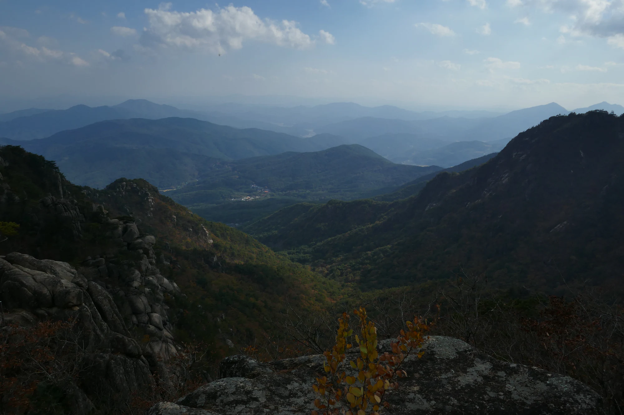
Granite rocks and autumn-tinted forest in the foreground, with layered blue mountain ridges beneath a cloudy sky.

Rocky forested slopes and distant ridges photographed during a Gayasan hike in October 2023.

“2023--23 October--Hike to Samwangbong & Chilchulbong in Gayasan National Park, Korea” by Phil Venditti (LittleRoamingChief), CC BY 2.0. · Creative Commons 1 · Creative Commons 2

Walks and routes

Sorigil: choose the whole valley or a shorter section

KNPS describes about 6 km from the lower Sorigil entrance by the Daejanggyeong Theme Park area to Yeongsangyo. Its listed sections total 2 hours 30 minutes one way, before pauses or a temple visit. The lower approach begins in rural scenery, then enters pine woodland beside the valley. Nongsanjeong is a good cultural stopping point, associated with the scholar Choe Chiwon. Beyond it, stone steps and a short steeper stretch interrupt the easier walking. Yeongsangyo is the published route endpoint; allow additional time to reach and explore Haeinsa. For a leisurely outing, choose a short out-and-back instead of assuming the full walk will fit around a bus departure.

Sorigil: choose the whole valley or a shorter section

Haeinsa to Sangwangbong: the southwestern summit approach

The official route follows the Toshingol approach from near Haeinsa towards Sangwangbong. KNPS gives 3 km to Jungbong and another 1 km to the summit, with section times adding to 2 hours 30 minutes uphill. The later stretch has steeper stone, timber and metal stairs. Use this as a serious mountain walk, not an extension to squeeze in after a late temple visit. The Geungnakgol side branch is identified as closed in the route description: stay on the signed main route. Return by your planned open route and keep the temple visit optional if the ascent takes longer than expected.

Haeinsa to Sangwangbong: the southwestern summit approach

Baegundong via Yonggigol: a steadier ascent, then steep summit stairs

Gayasan Course 2 climbs from Baegundong through Yonggigol to Seoseongjae, then continues to Chilbulbong and Sangwangbong. KNPS lists 2.6 km and 1 hour 30 minutes to the pass, 1.2 km and an hour to Chilbulbong, then 0.2 km and 10 minutes to Sangwangbong. That makes 4 km and 2 hours 40 minutes one way on the published sections. The valley gives a gentler start than Manmulsang, but the upper ridge remains steep, with frequent stairs. Decide at Seoseongjae whether conditions and remaining energy justify continuing. Turning back there is a complete choice, not a failed summit day.

Baegundong via Yonggigol: a steadier ascent, then steep summit stairs

Manmulsang: a demanding ridge to Seoseongjae

From Baegundong, Manmulsang climbs through dramatic rock formations, repeatedly losing and regaining height before reaching Seoseongjae. The booking page describes this as 3 km and 2 hours 30 minutes one way to the pass; this is not a complete summit circuit or return time. KNPS warns of seven major rises and falls, steep rock and many stairs. At the pass, the signed Yonggigol route provides a descent option, subject to current controls. Only continue towards the high peaks with adequate daylight, weather and stamina. Leave the route for another day if rain, ice or exposure would make the rock sections uncomfortable.

Manmulsang: a demanding ridge to Seoseongjae

Namsanjeilbong: a separate southern mountain outing

Namsanjeilbong reaches 1,010 m and has its own approach choices. From Cheongnyangdong, Course 1 is 2.3 km one way, with published sections totalling 1 hour 50 minutes; Cheongnyangsa adds temple interest, but the ascent is steep and rocky with numerous stairs. Course 2 starts at Dwaejigol and is 2.6 km one way, with a published uphill time of 1 hour 30 minutes. It begins more gently but steepens near the summit and has icy sections in winter. Choose one approach and verify its return route; a lower summit is not automatically an easy walk.

Namsanjeilbong: a separate southern mountain outing

A flexible temple-and-valley day

Arrive on the Haeinsa side, check the return journey, and give the temple the first substantial part of your visit. After a meal or break, choose a Sorigil section that fits the time and energy left. If using the full one-way trail, arrange your arrival and exit at its different ends before walking. Keep space in the day for steps, photographs and worship-related access changes rather than scheduling every minute.

A committed Baegundong hiking day

Start early with the whole route, descent and transport already decided. Choose Yonggigol for the steadier ascent, or Manmulsang only with the fitness and any required reservation for its ridge. Use Seoseongjae as a deliberate decision point. Take the upper peaks only if the weather remains suitable and your return margin is generous. Do not add a cross-mountain finish at Haeinsa unless its onward transport is genuinely arranged.

Things to try

Read Haeinsa through its buildings

Look at the depositories as a carefully designed home for fragile wooden printing blocks. The UNESCO inscription recognises both the buildings’ conservation solutions and their relationship with the Buddhist texts. You can appreciate this purpose without entering a storage room. Give worship areas space, pause outside busy doorways and follow staff instructions about where you may stand or photograph. UNESCO’s short introduction is useful reading before arrival.

Stay overnight only with a separate plan

A Templestay can add structured time for temple life, but it has its own arrival schedule and participation rules. It should not be treated as a casual mountain hut after a late descent. Browse Haeinsa’s official programmes and confirm what your chosen stay includes, particularly any access to the depositories.

Shorten the outing rather than forcing a ridge

If weather undermines the mountain plan, consider a shorter temple visit only if the access road and precinct are open and safe. Do not substitute a swollen streamside walk for a closed ridge. In severe conditions, leave the park visit for another day. Indoor access at Haeinsa is controlled, so it should not be assumed to provide unrestricted shelter.

Wildlife and habitats

Asian small cats (Prionailurus genus)

Prionailurus is a genus of small cats; the associated nature entry covers that wider group. Gayasan’s documented member is the leopard cat, Prionailurus bengalensis, which KNPS names as the park’s flagship animal. Its presence is a conservation story, not a promised sighting or a reason to leave the path. For a more realistic nature focus, enjoy the valley woodland and look for seasonal flowers from the trail. Never feed animals or disturb rock crevices to obtain a photograph.

Stories and discoveries

Highest peak and principal peak are different

KNPS identifies Chilbulbong at 1,433 m as the highest peak, while treating Sangwangbong at 1,430 m as the principal peak for historical and symbolic reasons. The names on a route plan therefore matter more than simply asking for “the summit”.

When to visit

Spring flowers and autumn leaves

KNPS identifies seoraengcho, a small primrose, in the high rocky habitat in April–June. View flowers only from the permitted trail. Autumn brings colour to the valley and slopes, but exact peak foliage dates vary with elevation and weather. Give crowded stairways space, and avoid stopping where others cannot pass.

Summer rain and winter ice

After heavy rain, valley walking may be restricted as well as summit hiking. In winter, the upper stairs and shaded rock sections can be icy, and entry cutoffs are earlier. Select a day and route that match your experience; specialist footwear or equipment does not make a closed trail available.

Getting there and practical advice

Use the gateway before the mountain

The official route descriptions identify trail support centres and toilets at the main approaches, including Baegundong and Toshingol. Use facilities before climbing and carry what you need for the day. Sorigil has rest areas and toilets along its documented sections, but confirm present availability at the support centre rather than relying on every facility being open.

Reach the correct side

For Haeinsa, the temple’s directions describe travel from Daegu Seobu Bus Terminal to Haeinsa Bus Terminal; from Dongdaegu Station, they direct travellers through Daegu Metro Line 1 to Seobu Bus Terminal Station. Verify current departures, the appropriate alighting stop and the last return service. For Baegundong, KNPS directs visitors to the parking area at 17 Gayasan-sikmurwon-gil, Suryun-myeon, Seongju-gun. These gateways are not interchangeable. If you want to finish at the other gateway, arrange that transfer before starting your walk.

Ask specifically for the upper Sorigil section

KNPS describes the 0.9 km Gilsangam–Yeongsangyo stretch as barrier-free, with adapted trail features and dedicated accessible parking. Its designation does not cover the earlier stone-step sections or the climb into Gilsangam itself. Before travelling, ask about the best drop-off, parking access, path gradients, closures and accessible toilets for your particular needs. Haeinsa and the summit routes require separate access enquiries.

Manmulsang reservations and entry cutoffs

Checked on 18 October 2026: the Manmulsang booking page lists a reservation period of 1 September–31 October, internet or on-site registration, and a daily limit of 340 people. It gives entry cutoffs of 13:00 in April–October and 12:00 in November–March. Other routes have their own limits. Book ahead during the reservation period, recheck the rules for your date and start well before the final permitted entry. The published cutoff is not a recommended starting time for a full summit day.

Toshingol and Yonggigol entry windows

The official entry table checked on 18 October 2026 lists Toshingol and Baegundong’s Yonggigol entrance as 04:00–14:00 in April–October and 05:00–13:00 in November–March. At Seoseongjae, uphill passage towards the summit closes at 15:30 in April–October and 14:30 in November–March. These are control limits, not suggested start times; allow a comfortable descent margin and follow any earlier instructions at the trailhead.

Current trail status

On 18 October 2026, the detailed Gayasan control page listed normal operations following the reopening of designated trails on 31 August. Check that page again before departure: weather controls can change quickly, and a general reopening does not allow access to restricted side paths.

Sources and useful links

Wildlife you might spot

1

Each card links to a full Explore page with photos, traits, and fun facts.

We are still adding species preview cards for this place.

Snap map for this place

Start with the big picture, then zoom in to explore individual wildlife observations around this place.

Loading map…

Good to know before you go

Save the Korean gateway names

해인사 for Haeinsa and 백운동탐방지원센터 for Baegundong Trail Support Centre. A generic search for Gayasan can send you to the wrong mountain or entrance.

Bring water, food, a charged phone, a light and an extra layer for a mountain day. Leave enough time and energy for the descent.

Check the final return bus before setting out. A one-way walk needs a return plan even when its published duration looks short.

Keep away from stream edges during heavy rain, and avoid exposed rock routes in thunderstorms or strong wind.

At Haeinsa, keep voices low, respect worshippers and follow local photography and entry signs. The depositories are protected heritage, not unrestricted exhibition rooms.

Frequently asked questions

Yes. Haeinsa and a short Sorigil section make a satisfying lower-level visit. Choose your walking distance around your group and transport rather than committing to the entire valley route.
Do not count on an interior visit. On 18 October 2026, Haeinsa’s official weekend Templestay listing still carried a temporary suspension notice for its depository-interior pilgrimage. Other visits or programmes may have different arrangements. Confirm the exact programme with Haeinsa before booking travel around it.
It is a strenuous ridge with repeated climbs, descents and steep rocky sections. KNPS directs inexperienced hikers towards Yonggigol instead, though that route’s upper summit approach is also steep. A lower valley walk is the better choice if your group is unsure about mountain stairs or exposure.
Treat parking, camping, temple programmes and any separately managed attractions as separate services. Check the relevant operator’s current charges and booking rules; a trail reservation is not a parking or temple-programme booking.

Recent snaps at this place

Recent snaps will appear here as new observations are added.

View all ›

Take the discovery with you

Exploring Gayasan National Park?

Identify the wildlife you spot, learn as you go, and keep a collection of the adventure.

  1. 1Spot it
  2. 2Snap it
  3. 3Keep the discovery
