Snappit logo
Snappit
Get App
Generic illustration, not a photograph of this venueIllustration
ParkKyushu, Japan

Genkai Quasi-National Park

Tachibanayama rewards looking up.

About

Tachibanayama rewards looking up. Broad trunks divide into great limbs, smaller trees fill the spaces between them, and the camphor canopy turns an ordinary pause into the best part of the walk. Come for the forest and give yourself permission to turn around before the summit.

This is one inland sector of Genkai Quasi-National Park, whose coast and islands extend across Fukuoka, Saga and Nagasaki. Tachibanayama stands where Shingu, Hisayama and Fukuoka City meet. The forest belongs to the protected park; the village lanes, parking areas and café below it are your approach, rather than a single landscaped park entrance.

Start on the Shingu side at Tachibanaguchi and use the main Tachibanayama trail towards the signed camphor-forest branch. The famous Ōkusu, or giant camphor, is a woodland destination in its own right. Its sprawling crown makes more sense when you step back on the path and look at the surrounding forest, rather than squeezing close to its roots for a photograph.

This is still a hillside hike. There are steep stretches, steps and uneven ground before you reach the giant trees. The 367-metre summit adds an uphill extension and, on a clear day, a view across the city towards Hakata Bay. It is a good extra for a group with energy left, but the camphors do not need a summit finish to make the day worthwhile. Wondering what that bird or insect is? Find out on your visit using the Snappit nature app.

Tachibanayama was the site of a mountain castle associated with the Tachibana family, including the warlord Tachibana Dōsetsu. Its surviving traces belong to a much older layer of the landscape than the modern city below. The camphor forest was designated a Natural Monument in 1928 and a Special Natural Monument in 1955; Genkai’s park designation followed in 1956.

What to do here

Take a slow out-and-back through the camphor woodland, pausing at the giant tree where the signed path allows. Compare the canopy with the shrubs underneath, then return to Tachibanaguchi. Add the summit only if everyone is comfortable with more climbing.

Seasonal info

Spring brings fresh leaves; autumn adds patches of colour among the evergreens. Summer heat and humidity can make the climb tiring even in shade. In winter, shorten the plan for limited daylight and postpone if the path is icy.

Accessibility

The forest and giant-camphor route has climbs, steps and rough footing. It is not a wheelchair or stroller outing. For a visit based at the village facilities, ask ahead about entrances, slopes and accessible toilets.

Don't miss

1

The spreading crown of Tachibanayama’s giant camphor

2

A protected woodland with smaller evergreen plants beneath the old trees

3

An optional summit view towards Hakata Bay

4

A pause at the restored Kominka Mikan house below the trail

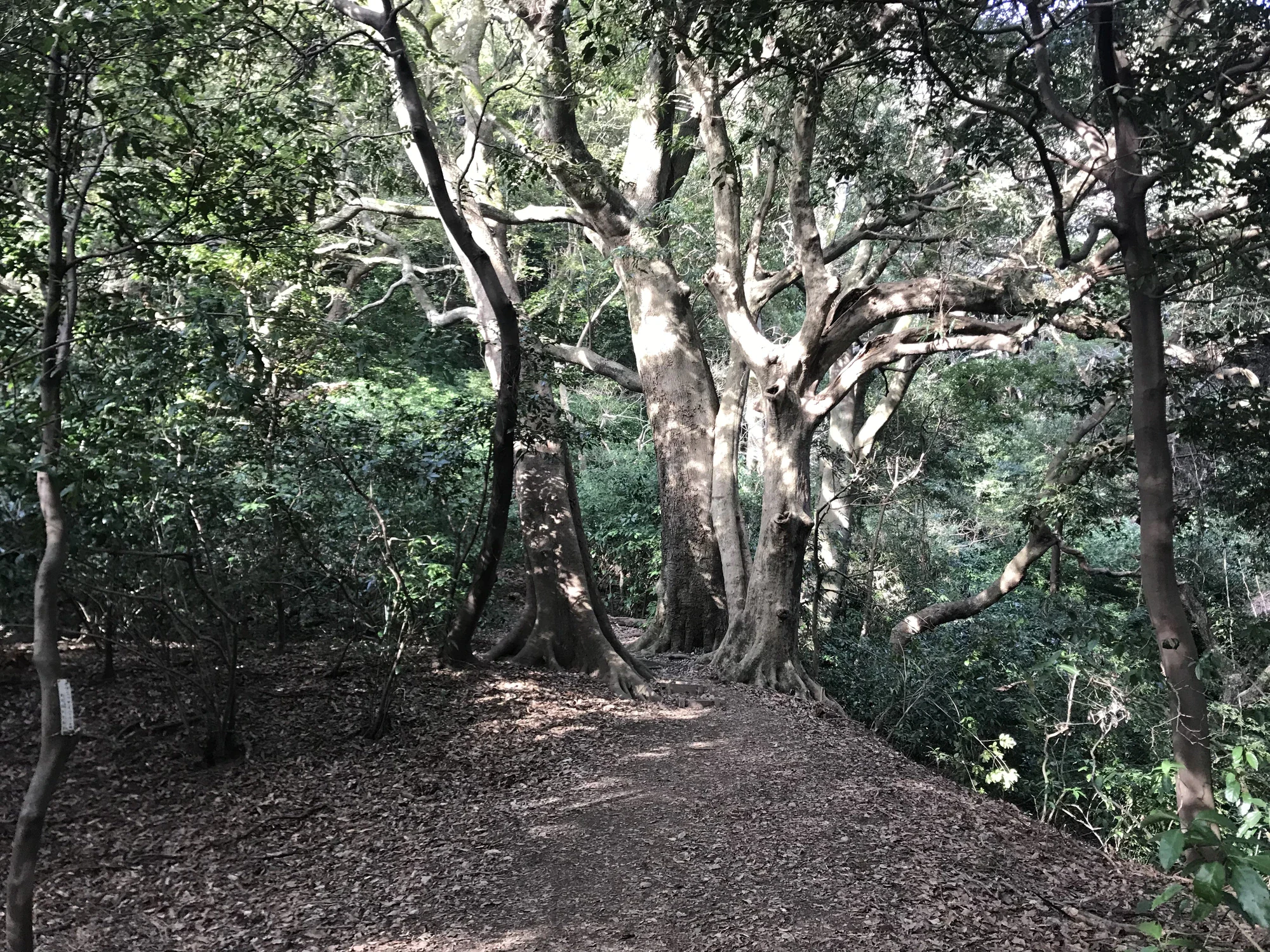
A leaf-covered earth trail passes large branching trees beneath a dense green canopy.

Broad-limbed trees beside a woodland trail on Tachibanayama, photographed in February 2018.

View on Mount Tachibanayama 12.jpg — そらみみ, CC BY-SA 4.0 (https://creativecommons.org/licenses/by-sa/4.0/). Source: https://commons.wikimedia.org/wiki/File:View_on_Mount_Tachibanayama_12.jpg. Proportionally resized to a maximum 2000-pixel long edge without upscaling; recompressed as WebP quality 92, method 6. No crop, retouching, added text or colour changes. EXIF omitted. · Creative Commons

Walks and routes

Make the camphor forest your destination

From the signed Tachibanaguchi hiking entrance, take the main Tachibanayama route. Use the signs for the camphor forest and Ōkusu branch rather than following a castle-wall circuit. Pause at the giant tree, then retrace your approach. If a sign is unclear, return to the last clear junction instead of trying a shortcut.

Expect uphill effort, timber steps and uneven natural surfaces. A shorter turnaround reduces distance but does not make the approach step-free.


Make the camphor forest your destination

Add the summit only if it suits the day

After the forest branch, return to the main trail and assess the climb to Tachibanayama’s summit. In clear weather, the bay and city provide a satisfying change from the enclosed woodland. Descend towards the same Tachibanaguchi starting point; paths towards Mikazukiyama, Shimobaru or other peaks lead away from your planned finish.

This adds climbing and a descent on rough mountain ground. Do not continue just because the summit looks close on the leaflet.

Add the summit only if it suits the day

A forest-first half day

2–3 hours walking and stopping, plus transport

Reach Tachibanaguchi with your return journey already chosen; check the trail notice and use the toilets.

Walk slowly up the main route, then take the signed camphor-forest branch. Stop early if the terrain asks more of the group than expected.

Spend time at the giant tree from the path, then return the same way.

If it is open, finish with a short stop at Kominka Mikan before your bus or drive home.

Forest and an optional summit

3–4 hours in total, plus transport

Start with enough daylight and supplies for a longer outing.

Visit the forest branch, then return to the main trail and decide together whether to continue uphill.

Take the summit extension only in suitable conditions, keeping the return bus or parking gate time in mind.

Retrace the main approach to Tachibanaguchi rather than following a different mountain exit.

Things to try

Find three different tree shapes

Choose a safe place to stand and compare three crowns or trunks. Which tree branches low, which reaches straight up, and which spreads widest? A quick sketch is a good excuse to slow down.

Listen at one quiet stopping place

Let the group be quiet for a minute. Notice sounds above you, near the ground and beyond the forest. Keep the path clear and avoid playing bird calls to bring wildlife closer.

Save the wide view for the right day

If the summit is clear and everyone still feels strong, compare the crowded city below with the forest around you. If cloud or tired legs win, turn back with the tree walk already complete.

Stay with the village visit

If conditions are simply damp and travel is safe, an open Kominka Mikan can make a shorter stop for local history and a drink. Check café service first. It does not require committing to the forest climb.

Postpone the mountain in severe weather

Heavy rain and strong winds are a reason to choose an indoor day near your accommodation. Genkai’s exposed coast is not a reliable bad-weather substitute for the forest. Return when the weather and trail notices support a better outing.

Wildlife and habitats

Camphor: follow the branching pattern

Look from the massive trunk to the crown, then at a low leaf you can see without picking it. Camphor leaves have three prominent main veins. Nearby laurel-family trees can look similar, so use the labels rather than a single feature to decide what you are seeing.

Japanese aucuba: the forest at eye level

Aucuba grows beneath the tall trees. Its broad, opposite leaves have coarse teeth towards their upper edges. Look for the contrast between this low layer and the canopy, without pushing into the vegetation.

Wild camellias among the evergreens

Yabutsubaki, the Japanese camellia, is part of this woodland’s understorey. A flower can make it easier to recognise: look for red petals, but enjoy the green foliage when no flowers are showing. Leave blossoms where they fall.

The trees are the main attraction. Look at plants from the path and let any birds or other animals appear in their own time. These prompts are about noticing the woodland, not collecting it.

A little preparation for the woodland

Wear long sleeves and long trousers for the woodland, and check clothing and skin for ticks afterwards. Stay out of long grass where you cannot see your feet, and move away quietly from wasps rather than waving at them. If you meet a wild boar, give it room and withdraw calmly without shouting or approaching piglets. Never leave food behind.

Stories and discoveries

A giant with a recorded size

The Forestry Agency lists the famous Ōkusu at about 30 metres tall with a trunk circumference of 7.85 metres, and estimates its age at more than 300 years. The whole surrounding woodland is worth attention too.

The smallest plants need protection too

Fukuoka’s account of the forest names shrubs, vines and ferns beneath the camphors and identifies trampling as a threat. Staying on the path protects much more than the roots of the biggest tree.

A sea-facing park with an inland forest

Genkai is best known for its coastline, but Tachibanayama’s camphor woodland is part of the same protected landscape. A summit view helps put the forest and coast together without having to visit both in one day.

When to visit

Spring

Fresh foliage gives the evergreen woodland a bright new layer. Choose a dry day and look at young leaves without plucking them. Flowering varies, so make the forest itself the reason to come.

Summer and the rainy season

Shade does not cancel humid heat. Start with plenty of water, pause often and shorten the climb if the group is struggling. Postpone for heavy rain, thunderstorms or strong winds, and check for trail damage after storms.

Autumn

Enjoy colour in the mixed woodland while the camphors remain green. Watch your footing on leaves and keep away from wasp nests. Set a return time that leaves daylight to spare.

Winter

The evergreen canopy still gives the walk a strong sense of enclosure. Carry a warmer layer and keep the outing shorter as daylight fades earlier. If frost or ice makes footing doubtful, save the hike for another day.

Getting there and practical advice

Toilets before the climb

The tourism association identifies toilets at the Rokusho Shrine parking area and on the approach from the hikers’ parking area towards the trail entrance. Use one before heading uphill; do not plan around finding another on the mountain.

Kominka Mikan

This restored old house at Tachibanaguchi offers a useful stop for local information and a break. The current listing gives 09:00–17:00, closed Wednesdays and over the year-end holiday. Check the day’s opening and café service before relying on refreshments; telephone 092-405-0808.

Trail information and emergencies

Pick up or save the town leaflet before you climb. Numbered rescue-point signs are shown on its map: if you need emergency help, call 119 and give the nearest sign number if you can do so safely. Carry your own supplies rather than relying on the trailhead’s loan walking sticks being available.

Train and the Marinks community bus

From JR Fukukōdaimae or Nishitetsu Shingu, take the Sanraizu / Sunrise line towards Saya, destination number 4, and alight at Tachibana Shōgakkō-mae. Allow roughly 20 minutes on village lanes to reach the hiking entrance. The return direction towards Nishitetsu Shingu uses number 3. The published flat fare is ¥100 per ride on the route.

Use the October 2026 timetable

Marinks changes its timetable on October 17, 2026. For visits on or after that date, use the revised timetable linked from the town’s notice and select the correct weekday, Saturday or Sunday/holiday column. Check both directions; do not depend on a convenient bus turning up after the walk.

Driving and parking

Aim for the signed Tachibanayama hikers’ parking areas at Tachibanaguchi. Read the notice at your chosen lot before leaving the car. Kominka Mikan’s current information lists first/second-lot access as 09:30–17:00, with Wednesday closure and no reopening after gates close; confirm which restriction applies to your lot. Village access roads can be narrow.

For wheelchair users and stroller days

Choose another nature outing if your main aim is a step-free forest path: the giant-tree walk here requires rough uphill travel. If you want to visit Kominka Mikan and the village instead, contact the facility about entrance steps, parking and toilet arrangements before travelling.

Public transport and pacing

Marinks describes its fleet as non-step buses. That does not remove the sloping walk from the stop or the mountain trail beyond it. Ask the operator about boarding support for your journey, and allow extra time between the stop and the village facilities.

For knees, balance and tired legs

Allow as much care for descending as climbing. Use short steps, pause on stable ground and turn around while everyone still has enough energy for the way back. The lower path is already a useful test of whether to continue.

Sources and useful links

Wildlife you might spot

3

Each card links to a full Explore page with photos, traits, and fun facts.

Snap map for this place

Start with the big picture, then zoom in to explore individual wildlife observations around this place.

Loading map…

Good to know before you go

Leave the Ishigaki stone-wall route out of your plan. The official tourism page still carries its landslide closure notice, checked October 16, 2026. Follow barriers and ask about the main trail before starting.

Save the town’s walking leaflet, but follow newer closure signs over any route drawn on the older map.

Wear shoes with grip and bring water, a snack, waterproofs and a charged phone. The walk back down needs energy too.

Use the base toilets before climbing and carry your drinking water; a water symbol on the leaflet is not a promise of treated drinking water.

Take photographs from the path. Keep off exposed roots and leave leaves, bark, flowers and fungi where they are.

Choose your return bus before setting off. The Marinks timetable changes on October 17, 2026.

Read your car park’s closing notice before walking away. Do not block village lanes or assume a locked gate will be reopened for you.

Frequently asked questions

Yes. The giant-tree branch is separate from the final summit climb. You still need to walk uphill on a mountain trail to reach it; it is not beside the car park.
No. This visit is the Tachibanayama forest sector. Coastal places such as Shingu Beach need their own travel and weather plan; they are not the next stop on this woodland walk.
There is no general mountain admission ticket for the outing described here. Budget separately for transport, refreshments and any other activities you choose.
Choose it for children who can manage sustained uphill walking and careful steps down. Keep a generous turnaround time and let the shortest comfortable forest walk be the whole outing.
Shingu Town’s tourism team is on 092-962-0238, and the tourism association is on 092-981-3470. Ask specifically about the main Tachibanayama trail and the giant-camphor branch.

Recent snaps at this place

Recent snaps will appear here as new observations are added.

View all ›

Take the discovery with you

Exploring Genkai Quasi-National Park?

Identify the wildlife you spot, learn as you go, and keep a collection of the adventure.

  1. 1Spot it
  2. 2Snap it
  3. 3Keep the discovery