
Snappit logo
Snappit
Get App
Generic illustration, not a photograph of this venueIllustration
ParkProvence-Alpes-Côte d’Azur, FR

Port-Cros National Park

Port-Cros makes the boundary between land and sea feel unusually thin.

About

Port-Cros makes the boundary between land and sea feel unusually thin. The village gathers around a sheltered inlet; beyond it, paths enter Mediterranean woodland and emerge at small bays. The water belongs to the story as much as the trees. Seagrass meadows help support the marine ecosystem, while the island’s woods show how vegetation changes after farming and other disturbance recede.

This guide concentrates on Port-Cros island, in Hyères, rather than trying to fit two islands into one day. The national park also includes protected natural parts of Porquerolles, surrounding marine cores and a wider mainland and marine territory in the Var. Port-Cros and Porquerolles have different visitor rules, ferry arrangements and accessibility. Choose your island before buying your crossing.

Plage du Sud is a useful first destination because it gives the outing a clear turning point. The park describes a 30-minute walk to this small sandy beach. Add time for children, uneven ground, observations and the return. The beach can be busy, so treat the walk and woodland as part of the visit rather than making an empty stretch of sand the measure of success. Unlock an interactive field guide for this spot: get the Snappit app to identify nature on the go.

Created on 14 December 1963, the park was reshaped in 2012 to include protected natural areas of Porquerolles alongside its historic Port-Cros core. Its present territory also involves coastal communities. On Port-Cros itself, the woods are not simply a landscape untouched by people: the park’s interpretation describes former cultivation and terraces beneath today’s vegetation.

What to do here

Begin at the harbour and the Maison de Parc area, check the day’s path restrictions, then follow the signed way towards Plage du Sud. Make the beach your turnaround point. A snack, a sketch of the bay and a little time looking at shoreline plants are enough to make this a satisfying land-based outing.

Seasonal info

Summer brings heat, pressure on the small beaches and possible fire restrictions. Outside peak season, reduced ferry services and visitor-desk opening make advance planning especially important. A sunny mainland morning does not guarantee comfortable conditions at sea.

Accessibility

The route includes steps near the statue of Saint Joseph and natural paths. If you need a step-free outing, discuss a different island option with the park before travelling. Families with pushchairs should also ask about the terrain before choosing this walk.

Don't miss

1

A compact harbour backed by Mediterranean woodland

2

A clearly bounded walk to Plage du Sud and back

3

Plants that connect island woodland with the marine landscape

4

Time to explore without committing to the island’s longer ridge circuits

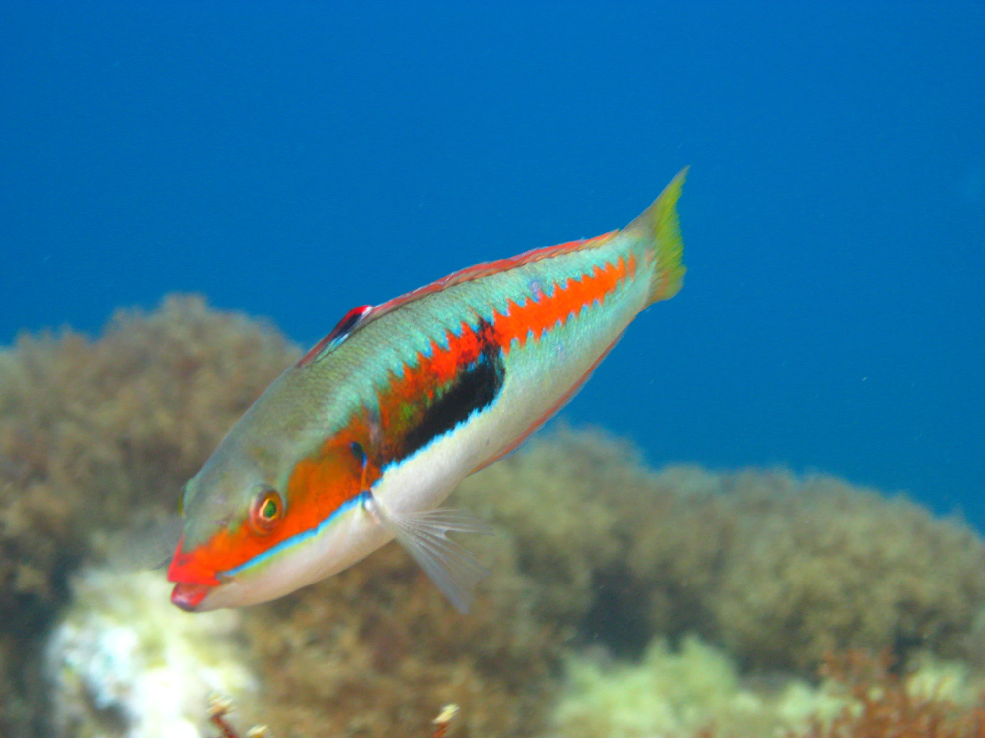
A turquoise-green fish with an orange-red side stripe and a broad black patch swims above a blurred rocky seabed in blue water.

A fish photographed at Port-Cros on 6 July 2014, identified by photographer Gilles Bassière as a Mediterranean rainbow wrasse (Coris julis).

“Port-Cros” by Gilles Bassière, CC BY 2.0. Original photograph, unchanged. · Creative Commons

Walks and routes

Port-Cros harbour to Plage du Sud and back

From the harbour, take the waterfront direction towards Plage du Sud. The park’s directions pass the small chapel of Saint-Tropez and Le Manoir, then reach the steps by the statue of Saint Joseph. Take the signed path towards La Pomme d’Or and Plage du Sud, passing the Anse de la Fausse-Monnaie. Stop at Plage du Sud and retrace your steps to the village. This suggestion uses only the beginning of the park’s Circuit des Crêtes; do not continue onto the ridge circuit or add the Pointe du Cognet detour.

Expect steps and an uneven natural surface, with a beach rather than an equipped promenade at the turning point. Assess the route against the least confident walker in your group. Choose a different outing if steps or uneven ground are a problem.

Port-Cros harbour to Plage du Sud and back

Before boarding, confirm the weather, fire-access notice and both ferry journeys. Buy the appropriate ticket and leave enough time for parking or your onward connection.

On arrival, locate the return boarding point. If the Maison de Parc is open, ask about the day’s path conditions and the Plage du Sud approach.

Walk to the beach at the group’s pace, stopping only where you can let others pass. Have your snack and shoreline pause, then return along the same route.

Keep your remaining time near the harbour. Check the operator’s latest instructions before boarding for the mainland.

Things to try

Follow the change from harbour to woodland

Give each child a small observation job: notice where the canopy closes, find a leaf shape that repeats, or draw the outline of the bay from a safe stopping place. Compare notes at the beach. The aim is a few things remembered, rather than a long species checklist.

Read the shoreline from dry land

At the beach, look at the meeting of sand, rock and stranded leaves without disturbing it. Take a wide photograph, then choose one small detail to draw. Keep children beside an adult and away from wave-washed rocks; the beach is not supervised.

When the sea or weather changes the plan

If strong wind, rain or an access restriction undermines the outing, save the crossing for another day. Port-Cros is not a dependable indoor rainy-day destination. The park’s virtual island visit can introduce the landscape and marine habitats while you choose a better day to go. If already ashore, ask staff or your boat operator what to do rather than extending the walk.

Wildlife and habitats

Holm oak — Quercus ilex

The island’s evergreen woodland is one of its defining habitats. Holm oak can form tall trees in sheltered valleys or a lower, shrubbier canopy elsewhere. The park’s plant interpretation describes oaks gradually replacing ageing Aleppo pines. Look at leaf shape and the changing shade from the path, without snapping off a sample.

Strawberry tree — Arbutus unedo

Strawberry tree is part of Port-Cros’s tall Mediterranean scrub, alongside tree heath. Its reddish trunk and, in late autumn, possible combination of pale bell-shaped flowers and red-orange fruit make it worth learning. Look rather than pick: the park is a place to observe these plants, not to forage.

Neptune grass — Posidonia oceanica

Beneath the water is a flowering plant, not an alga. Posidonia forms meadows that help stabilise the seabed and provide habitat for marine animals; scientific surveys document it around Port-Cros. Its washed-up leaves also have a role on beaches. If natural leaf piles are present, leave them intact. A shore visit can introduce this habitat without entering the water.

Stories and discoveries

A forest with a past

Port-Cros’s woodland has grown over a more worked landscape. Former fields and terraces help explain why a walk here combines old walls, scrub and developing forest. The contrast between the harbour buildings and the wooded slopes is part of that long history.

Fresh water arrives by boat

The park’s harbour interpretation explains that island water supplies need support in the busy season, including deliveries by a tanker vessel. Carrying your own drinking water and using facilities sparingly are practical ways to respect an island resource that is easy to take for granted.

The park continues beneath the surface

The protected marine fringe is integral to this national park. The fish photograph below is a historical glimpse of that underwater world. It is an invitation to understand marine conservation, not an indication that a particular animal will be visible from the footpath.

When to visit

Fire-risk days

Check the Var fire-access map before leaving the mainland and again against the signs on arrival. The park’s Port-Cros guidance says that at red risk only a designated path towards Plage du Sud remains open; at red-extreme, all island paths close. Follow any stricter local instruction. The park advises postponing in restricted conditions, which is the sensible family choice.

Spring, autumn and winter

A quieter island visit still needs a complete travel plan. Check whether the service runs that day, how much time you will actually have ashore, and whether the visitor desk is open. Take an extra layer, leave spare time before the return and keep the plan short if conditions change.

Getting there and practical advice

Visitor information and food

The Maison de Parc at Port-Cros is the useful first contact: +33 (0)4 94 01 40 70. The park currently lists a May–September reception season; check opening for your date, particularly outside summer. Bring food rather than relying on a particular island business being open.

Water and toilets

There are no water points outside the villages. Ask at the harbour about available toilets before setting off. The government’s Plage du Sud site information lists no beach toilets, showers, lifeguard surveillance or rescue station. Do not plan to replenish supplies at the beach.

Keep the island visit light

Camping and bivouacking are prohibited in the core. Use no fire or cigarette on the walk, keep noise down, take rubbish back to a proper bin and leave wildlife undisturbed. Drones are prohibited in the core; an ordinary handheld photograph is the simpler souvenir.

Use the correct mainland harbour

For the TLV-TVM route to Port-Cros, depart from the port of Hyères, also called Port Saint-Pierre. Do not automatically head to La Tour Fondue, the usual Porquerolles departure point. The operator gives about 45 minutes for Hyères–Port-Cros; allow additional time for boarding and onward travel.

Book around the return

Check the date-specific Port-Cros timetable in both directions. Low-season services can have non-sailing days, and the operator may change or cancel sailings because of weather or technical problems. TLV-TVM strongly recommends booking in July and August; some low-season periods use ticket-office sales instead. Ask the operator about the exact sailing if the online display is unclear.

Budget for the boat

The park territory itself is free to enter, but the ferry is paid. For a useful budget reference, TLV-TVM publishes a 2026 Hyères–Port-Cros return fare of €29 for an adult and €25 at the reduced rate. Check current prices, eligibility and any reservation conditions before paying. Mainland parking and food are additional choices.

Match boat access and path access separately

TLV-TVM describes wheelchair boarding as available under conditions. Contact the operator about the actual vessel, boarding arrangements and assistance; this does not establish that the island footpath is accessible. Pushchairs can travel on its boats, but the Saint Joseph steps remain an obstacle on this walk.

A different island option for reduced mobility

If this terrain does not suit you, ask the park about a separate Porquerolles visit. Its accessibility information describes adaptations at Plage d’Argent, including a boardwalk and seasonal equipment. Confirm the operating dates, suitable transfer and assistance before travelling. The park also offers a virtual Port-Cros visit for exploring its land and marine environments from home.

Sources and useful links

Wildlife you might spot

3

Each card links to a full Explore page with photos, traits, and fun facts.

We are still adding species preview cards for this place.

Snap map for this place

Start with the big picture, then zoom in to explore individual wildlife observations around this place.

Loading map…

Good to know before you go

Write down the return sailing and the operator’s boarding instructions before leaving the harbour. Set a turnaround time that leaves room for a tired child and an unhurried return.

Bring drinking water for everyone, a picnic or snacks, sun protection and shoes with grip. Pack lightly enough that an adult can help a child on the steps.

Download the park’s directions before crossing and use the signs on the ground. A short out-and-back is easier to shorten than an unfamiliar loop.

Keep a light windproof layer handy for the boat, even when the village feels warm.

Photograph or draw what interests you. Leave plants, shells, stones and washed-up natural material where they are.

Frequently asked questions

It can suit children who are comfortable walking on natural ground with adult supervision. The official half-hour indication is not a promise of toddler pace. Turn back earlier if the steps, heat or footing feel too demanding; reaching the beach is optional.
For this Port-Cros outing, leave both behind. Pet dogs are restricted to the village, on a lead between Fort du Moulin and the statue of Saint Joseph; they cannot accompany the walk beyond it. Port-Cros is explored on foot. Porquerolles has different rules: dogs on leads on paths, no dogs on beaches, and regulated cycling.
No. The suggested outing stays on land. The underwater photograph introduces the park’s marine life, but does not show a place you will reach on this walk. A separate water activity needs its own assessment of conditions, ability, supervision and local rules.
Keep this first visit to Port-Cros. Porquerolles deserves a separately planned crossing and outing. Bagaud, La Gabinière and Le Rascas are protected integral-reserve islets, not additional stops to improvise by boat.
Postpone the island walk. Do not count on finding another boat or an unofficial path. If you are already on the island, follow the operator’s and park staff’s instructions and keep the return journey your priority.

Recent snaps at this place

Recent snaps will appear here as new observations are added.

View all ›

Take the discovery with you

Exploring Port-Cros National Park?

Identify the wildlife you spot, learn as you go, and keep a collection of the adventure.

  1. 1Spot it
  2. 2Snap it
  3. 3Keep the discovery
