Snappit logo
Snappit
Get App
Generic illustration, not a photograph of this venueIllustration
ParkKR

Seonunsan Provincial Park

In Gochang County, Jeonbuk Special Self-Governing Province, Seonunsan rewards a visit built around one main interest: spring camellias, September flowers, autumn streamside colour, Buddhist heritage or a proper mountain walk.

About

In Gochang County, Jeonbuk Special Self-Governing Province, Seonunsan rewards a visit built around one main interest: spring camellias, September flowers, autumn streamside colour, Buddhist heritage or a proper mountain walk. The lower approach gives you time among large trees; higher trails bring steps, rougher footing and rocky outlooks. Choose your turning point before enthusiasm carries you uphill, especially when a return bus or short winter afternoon sets the limit. Eager to name that creature? Identify any animal you find during your visit using the Snappit app.

Seonunsan became a provincial park in 1979. Its other name, Dosolsan, reflects the mountain’s Buddhist associations. Seonunsa and the surrounding hermitages belong to a long-lived religious landscape rather than an isolated monument visit. The Dosol Valley area also has scenic-heritage recognition, designated in 2009 for the combination of natural formations and cultural sites. Stories linking nearby Jinheunggul cave to King Jinheung are local traditions; enjoy them as stories rather than proof that every event happened at the surviving site.

What to do here

Make the stream-and-temple corridor your starting point. Visit Seonunsa quietly, look for its protected camellia grove, and continue towards Jangsasong pine and Dosolam if the route is open and your group has time. Beyond the hermitage, the rock-cut Buddha and the climb towards Yongmungul, Nakjodae and Cheonmabong make a more demanding outing. Keep the ridge extension optional.

Seasonal info

For autumn 2026, the county’s scheduled fire controls run from 1 November to 15 December. Its route attachment lists Courses 1 and 2 as open and Courses 3 and 4 as closed during the control period. This is not same-day clearance: weather, repairs or additional notices can change access. Check the [2026 control notice](https://www.gochang.go.kr/index.gochang?dataSid=798459&menuCd=DOM_000000107004000000&viewMode=view) before hiking.

Accessibility

The lower approach is the best starting point for visitors using wheels or avoiding steps. A Korea Tourism Organization access report documents level approach paths, a barrier-free nature trail and adapted facilities, but its detailed inspection dates to 2018. Confirm today’s usable route and facilities locally. Do not extend that description to Dosolam’s upper shrines or the mountain ridges.

Don't miss

1

Dosolcheon’s wooded banks and autumn reflections

2

Seonunsa’s protected camellia grove

3

Jangsasong pine and the hermitage landscape at Dosolam

4

Volcanic cliffs and higher views towards Cheonmabong

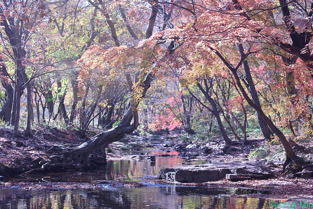
Red and gold autumn trees arch over a shallow rocky stream, with reflections in the water and a green Seongi Min signature at bottom right.

Autumn beside Dosolcheon, photographed on 13 November 2013 according to the source. The exact stretch of stream is unverified; this historic view does not show present access or foliage conditions.

“떠나가는 가을, by Seongi Min” by Seongi Min, shared through CC Photo & Share, CC BY 2.0. · Creative Commons 1 · Creative Commons 2

Walks and routes

Lower valley and Seonunsa

Begin at the main park arrival area and follow the signed approach towards Seonunsa. Spend your time beside the stream and in the publicly accessible temple grounds, then return along the permitted approach. This is a flexible out-and-back suggestion, not a measured circuit; shorten it whenever your group needs.

Ask for the current step-free line and accessible toilet before starting. Temple thresholds and individual halls require separate assessment.


Lower valley and Seonunsa

Course 1: Dosolam and Cheonmabong

The county lists the sequence via Seonunsa, Dosol rest area, Jangsasong, Dosolam, the rock-cut Buddha, Yongmungul and Nakjodae to Cheonmabong. Its 2026 route register gives 4.7 km for the designated course; the tourism page quotes 1½ hours one way. That is an indicative through-walking figure, not a leisurely return visit. Budget separately for stops and descent.

The higher section is a hiking route with steps and rocky terrain. Turning back around the hermitage avoids committing to the entire upper sequence, but does not make every hermitage approach step-free.

Course 1: Dosolam and Cheonmabong

Course 2: Suribong and Chamdangam

The ridge alternative passes Seoksangam, Maijae, Suribong, Pogaenbawi, Chamdangam and Sorijae towards Nakjodae and Cheonmabong. The control register records 6.1 km; the tourism page quotes two hours one way. Study the signed junctions and agree a descent before leaving the valley. Do not combine the two published one-way routes into an assumed easy loop.

A mountain option for walkers comfortable with sustained uneven ground and repeated climbs. Leave enough energy for the descent.

Course 2: Suribong and Chamdangam

Longer outer ridges: Courses 3 and 4

Course 3 takes the Gyeongsusan–Gyeonchisan side; Course 4 approaches through Dosolje and Cheongnyongsan. They are longer mountain choices, not extensions to add casually after sightseeing. The official control register gives 8.6 km and 8.3 km respectively. For a future visit when permitted, obtain the current trail board and plan a full hiking day with a clear exit.

These are unsuitable substitutes for a lower-valley walk when someone needs level ground or frequent easy exits.

Longer outer ridges: Courses 3 and 4

A relaxed first visit

Arrive with enough time to check the return journey, use the toilet and read the trail board. Walk the lower corridor, visit the open temple grounds and choose one plant highlight. Leave a generous margin for a slow return, especially with children or anyone who tires on uneven surfaces. A meal afterwards is easier to enjoy when the walking day has a clear endpoint.

A longer valley day

Start early enough that Dosolam can be an optional goal rather than a deadline. Pause at Jangsasong and the hermitage landscape, then decide whether the available daylight and conditions justify an upper section. If they do not, retrace the permitted valley route. Save the outer ridges for a day planned around hiking from the outset.

Things to try

Look at the rock as well as the Buddha

At Dosolam’s rock-cut Buddha, the cliff is part of the story. County geological interpretation identifies rhyolite and visible flow structures below the carving. Its reddish colour is linked to iron oxidation. Look from the permitted viewing area; there is no reason to touch the carving or scramble onto the rock for a closer view.

Streamside photography

Use the water, exposed stones and overhanging branches to frame the valley. Stay on safe public ground and let other walkers pass before setting up. The historic photograph below is inspiration for the landscape, not a pin for an exact shooting spot or a prediction of this year’s colour.

When rain changes the day

In light rain, a shortened lower-corridor visit may still suit your group if staff confirm it is open. A temple is an active place of worship, so do not assume every hall provides public shelter. With heavy rain, thunder, rising water or a closure notice, leave the valley and postpone the mountain walk rather than trying to salvage the itinerary uphill.

Wildlife and habitats

Camellias behind Seonunsa

The grove behind Daeungjeon Hall is a protected population of common camellia, Camellia japonica. Heritage interpretation describes roughly 3,000 trees and a tradition of planting them as a fire buffer in 1478. Look at the evergreen foliage as well as the flowers; this is a historic temple grove, not evidence of an untouched wild stand. Its unusually late local flowering makes spring the sensible season to plan around.

Pine: Jangsasong

Near Jinheunggul on the Dosolam approach, Jangsasong makes a worthwhile stopping point even outside flower season. Its spreading, divided crown is the feature to notice. The heritage account estimates an age of about 600 years and records natural-monument protection since 1988; that age is approximate. View the whole tree from the public path rather than pressing into the protected root area.

Tea plants in cultivation

The tourism organization’s lower-corridor account describes tea grown by Seonunsa beyond the stream crossing. Treat these as cultivated plots. Where the current public path permits a view, notice the contrast between repeated rows and the surrounding woodland; do not walk between rows or pick leaves.

Red flowers and the entrance ivy

The county identifies Seonunsan’s kkotmureut colony as a mid-September attraction. Plan to see flowers from established paths rather than searching for the densest patch off trail. Near the entrance, the large protected songak ivy across the stream is another distinctive plant feature documented by the tourism organization. The colony and the ivy are useful things to look for, without promising that either will look exactly like older photographs.

Stories and discoveries

A volcanic landscape softened by forest

Dosol Valley’s cliffs and weathered cavities developed in volcanic rocks including tuff and rhyolite. The woodland can hide how abrupt the terrain becomes above the stream. That change helps explain why a gentle-looking valley visit and a high-level traverse need different plans.

When to visit

Spring and September

For camellias, aim for the locally documented late-March to mid-April season, with a fresh bloom check close to departure. September’s kkotmureut display is a different visit: the county gives mid-September as the usual flowering period. A flower-led day works best with a short walking plan and time to wait for space on busy paths.

Summer, late autumn and winter

In hot weather, keep the outing shorter and carry enough water even when following a shaded route. After heavy rain, avoid stream edges and slippery upper rock. For late-autumn hiking, check fire controls before choosing a ridge. In winter, favour a daylight lower-valley visit when conditions allow; sheltered paths can still hold ice.

Getting there and practical advice

Arrival and essentials

The county lists parking at the main gateway, 158-6 Seonunsa-ro, Asan-myeon. Locate toilets and check any parking charge on arrival. Buy what you need before a long walk, and carry your own water rather than relying on a shop or refreshment point farther up the route being open. Camping and overnight temple programmes need separate arrangements.

Reach the main Seonunsa gateway

For public transport, use the county’s Gochang–Seonunsa bus timetable. It lists trips in both directions, but the page has no clear update date. Confirm the day’s departures and the correct boarding stop before leaving Gochang, then check your return at the park. Allow for walking time between the arrival area and the temple; do not time your hike to the very last departure. Drivers should navigate to the park’s main parking area and continue on foot as directed.

Choose a specific accessible outing

The older official access report describes accessible parking and toilets, tactile information and a nature-trail deck in the lower area. It also records gravel and a steep approach at one temple building. Ask which facilities are functioning, whether there are diversions, and how far your wheelchair or pushchair can go continuously without steps. If assistance is needed, arrange it before arrival. Keep an easy turnaround in the plan instead of assuming that an accessible entrance guarantees an accessible whole-day route.

Sources and useful links

Wildlife you might spot

3

Each card links to a full Explore page with photos, traits, and fun facts.

Snap map for this place

Start with the big picture, then zoom in to explore individual wildlife observations around this place.

Loading map…

Good to know before you go

Photograph flowers from the path. A narrow gap between plants is not an invitation to step into the colony.

Choose your return route as carefully as your outward route. Reaching a viewpoint is only the midpoint of the outing.

Carry water, a snack and a layer for exposed sections; take a light if a mountain walk could run late.

Leave worshippers room to move, lower your voice at temple buildings and follow local photography notices.

Wet rock, fallen leaves and shaded ice can make a modest-looking climb slow. Turn back before the footing exceeds your group’s ability.

Frequently asked questions

Yes. The lower corridor provides a coherent visit on its own. Keep the temple, stream and trees as your main outing, then return when you have had enough. You do not need to add Cheonmabong to make the journey worthwhile.
No. A comfortable approach walk says little about the steps and rough ground farther uphill. At Dosolam, treat an upper shrine or mountain-viewpoint detour as a fresh decision based on footing, energy and daylight.
The county’s park listing currently states free admission and free cultural-property viewing. Parking and any separately operated activity or accommodation should be checked independently; that listing does not establish every possible charge.
No. An annual fire-control schedule answers a different question from a same-day weather or repair closure. Follow current signs and staff instructions even where an older map or schedule shows a route as available.

Recent snaps at this place

Recent snaps will appear here as new observations are added.

View all ›

Take the discovery with you

Exploring Seonunsan Provincial Park?

Identify the wildlife you spot, learn as you go, and keep a collection of the adventure.

  1. 1Spot it
  2. 2Snap it
  3. 3Keep the discovery