
Snappit logo
Snappit
Get App
Generic illustration, not a photograph of this venueIllustration
ParkKR

Songnisan National Park

Songnisan rewards a clear choice about the kind of day you want.

About

Songnisan rewards a clear choice about the kind of day you want. The lower Beopjusa district puts a living Buddhist monastery beside forest and water, with no summit required. Above it, the paths become long, stepped mountain routes leading toward Munjangdae and Cheonwangbong. Farther north, Hwayang’s streamside scenery, Chilbosan’s rock formations and Daeyasan’s steep heights belong to the same national park, although they have different entrances. Pick one gateway, check its particular restrictions and leave time to enjoy it. A temple morning and a short forest walk can be a complete visit. Wondering what that bird or insect is? Find out on your visit using the Snappit nature app.

Songnisan became Korea’s sixth national park in 1970. Its major expansion in 1984 helps explain why today’s park extends well beyond the familiar Beopjusa mountain approach. Beopjusa is one of the seven monasteries inscribed together in 2018 as “Sansa, Buddhist Mountain Monasteries in Korea”. These are working religious communities as well as heritage sites.

What to do here

Explore Beopjusa’s courtyards and wooden Palsangjeon, then walk the lower Sejogil to the reservoir. If everyone is comfortable with more distance and steps, continue toward Sesimjeong and Bokcheonam. Strong hikers can choose Munjangdae as their main objective; a full temple visit and a summit day compete for the same daylight.

Seasonal info

Summer shade does not remove heat or flash-flood risk. In winter, wooden steps and shaded stone paths can ice over even when the entrance looks clear. Spring and autumn fire-prevention restrictions can affect higher routes. Check the exact trail, weather and daylight before setting out.

Accessibility

The dedicated KNPS Sejogil guide describes the experience-centre-to-reservoir section, 2.1 km one way, as suitable for wheelchairs and strollers. Beyond the reservoir, slopes and stairs change the picture. Ask about present surfaces, accessible toilets and temple-building access; a suitable approach does not make every hall or the entire valley walk step-free.

Don't miss

1

Beopjusa’s Palsangjeon and twin-lion stone lantern

2

Sejogil’s forest, reservoir and streamside scenery

3

Munjangdae’s rocky outlook, reached by a demanding mountain walk

4

Hwayang Valley as a separate northern-sector visit

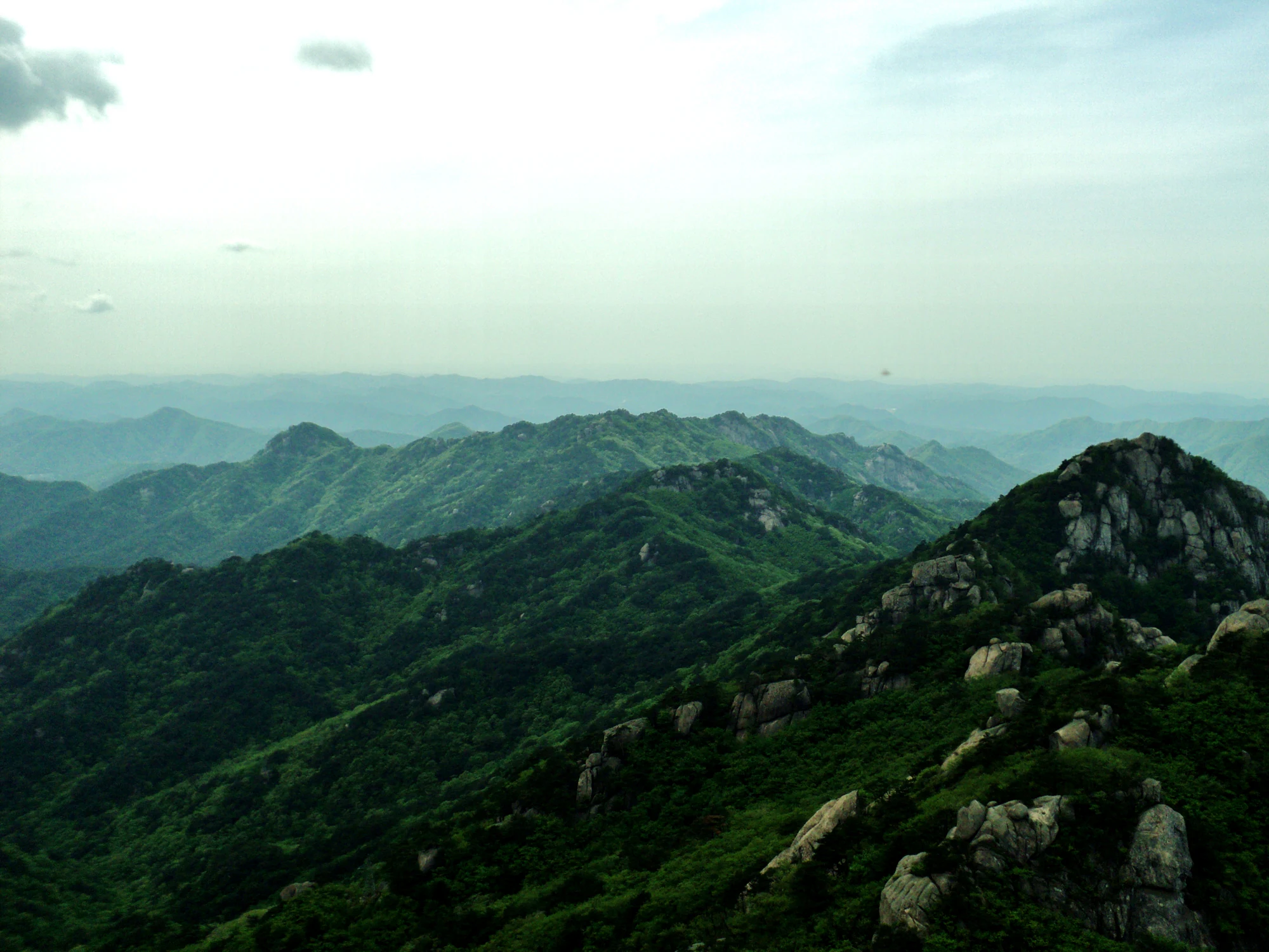
Green mountain ridges and exposed rock formations recede into a hazy distance beneath a pale sky.

Forested ridges and rocky outcrops at Songnisan, photographed in May 2011.

Photo: [“Songnisan” by Kyle (Kjmagnuson)](https://www.flickr.com/photos/kjmagnuson/14746532272/), Flickr. [CC BY 2.0](https://creativecommons.org/licenses/by/2.0/deed.en); original file unchanged. · Creative Commons 1 · Creative Commons 2

Walks and routes

Lower Sejogil: a flexible first walk

From the Songnisan Experience Learning Centre, follow the signed lower route through the Beopjusa junction to the reservoir: 2.1 km one way, or 4.2 km back to the same start. KNPS gives 35 minutes outward; allow much more for a relaxed return and temple detour. The water and wooded slopes give you a satisfying destination without committing to the upper valley.

This is the section KNPS describes as wheelchair- and stroller-suitable. Confirm current surface conditions and turning points at the centre.

Lower Sejogil: a flexible first walk

Full Sejogil to Bokcheonam

The complete course from the experience centre to Bokcheonam is 4 km one way, 8 km by the same route back. After the reservoir, the 1.4 km to Sesimjeong follows the valley; another 0.5 km reaches the hermitage. KNPS’s section times total 80 minutes outward. Budget roughly 3–4 hours for the out-and-back walk with stops, adding temple time separately.

The reservoir–Sesimjeong section has stairs and slopes; the final stretch mixes paved access with wooden steps. The full route is not a wheelchair itinerary.

Full Sejogil to Bokcheonam

Munjangdae from the Beopjusa side

From the experience centre, walk 3.5 km to Sesimjeong and 3.1 km onward to Munjangdae: 6.6 km one way, 13.2 km if you retrace your route. KNPS gives 3½ hours for the outward leg. Allow a full 6–8-hour walking day with breaks. The final approach steepens; this is a deliberate mountain day, not a casual extension of a temple stroll.

Stone steps, steep ground and summit stairs make this unsuitable for wheelchairs or strollers. Wear footwear with dependable grip.

Munjangdae from the Beopjusa side

Munjangdae from Hwabuk

The Hwabuk Visitor Support Centre approach is 3.1 km each way, 6.2 km return. KNPS gives 2½ hours uphill and describes an approximately four-hour return outing; plan 4–5 hours with breaks. It is shorter than the Beopjusa approach but includes sustained stone steps and a steep final climb. At the descent junction, follow signs back to Hwabuk.

The upper route and final metal stairs are steep. A shorter distance does not make this an accessible or easy walk.

Munjangdae from Hwabuk

Sujeongbong: a short climb above Beopjusa

Opened on 26 September 2026, the Beopjusa–Sujeongbong trail is 0.8 km uphill to the 576 m summit and 1.6 km return. KNPS gives about one hour for the return hike. The appeal is a view down toward the temple; add it only if you have time and suitable conditions after your visit.

This is a hill climb with gradients, not an extension of the step-free lower path. Allow extra time for rests and footing.

Sujeongbong: a short climb above Beopjusa

Hwayang: a separate streamside outing

In the northern Hwayang sector, KNPS describes 1.5 km from the visitor support centre to Cheomseongdae, taking about 30 minutes one way. Return the same way for a 3 km lower walk. Hwayang’s named rocky scenes and the setting around Hwayangseowon give this valley a different character from Beopjusa. The climb toward Domyeongsan is a separate, more demanding choice.

The lower centre–Cheomseongdae section is described as level and suitable for wheelchairs and strollers. Mountain branches involve steep stairs and rock.

Hwayang: a separate streamside outing

An unhurried first visit

Start with the experience centre if open, then spend time at Beopjusa and walk toward the reservoir. Choose your turnaround before anyone is tired. Have lunch back near the gateway, or continue to Sesimjeong only if the group wants a longer, stepped walk. Keep the afternoon flexible rather than making a summit the measure of success.

A mountain-focused day

Start early from either the Beopjusa side or Hwabuk, with Munjangdae as the main objective. Check weather and controls, carry food and water, and set a personal turnaround time well before darkness. Leave the combined Cheonwangbong circuit to a separately planned day suited to the group’s fitness.

Things to try

Give Beopjusa its own time

Palsangjeon’s stacked wooden roofs, the twin-lion stone lantern and the large gilt Maitreya Buddha offer three very different scales to look at. Walk the public courtyards slowly rather than using the monastery only as a checkpoint on the way uphill. This is an active temple: keep entrances clear and follow signs about shoes, photography and restricted spaces.

Explore the other sectors on another day

Chilbosan pairs dramatic rocks with the Ssanggok valley landscape, but the usual Tteokbawi start is affected by the present closure. Daeyasan has steep mountain terrain, including a difficult upper Pia-gol section. Neither is a spare-hour addition to Beopjusa. KNPS explicitly places nearby Yongchu Falls and Mudangso outside the national-park area, so enjoy them as neighbouring sights without enlarging the park’s boundary.

When heavy rain changes the plan

The 28 August 2026 notice closed all park valley sections until the rain ended and safety checks were complete. Later route-specific information is more useful for walking plans, but it does not authorize entering the water. If warnings or barriers affect your visit, postpone the valley and ridge walks. Ask whether the experience centre is open before treating it as an indoor alternative.

Wildlife and habitats

Woodland birds, with realistic expectations

Black Woodpecker, Eurasian Jay and Eurasian Nuthatch are documented for the park in published research. These records make them worthwhile species to learn before a walk, not promised sightings along Sejogil. Bring binoculars, stop where the path is wide enough to let others pass, and watch quietly without playback or approaching nest holes.

Two distinctive conservation flagships

KNPS highlights Korean berchemia, Berchemia berchemiaefolia, and Siberian flying squirrel, Pteromys volans, as the park’s flagships. The tree is associated with rocky ground; the squirrel is nocturnal and uses tree cavities. Learn about them through park interpretation rather than searching off-trail. These are conservation interests, not guaranteed sightings on a short walk.

Stories and discoveries

A landscape made from more than granite

KNPS describes granite alongside metamorphosed sedimentary rocks. The contrast helps explain the park’s mixture of exposed rock towers and deeply cut valleys. The 1,058 m Cheonwangbong is the highest summit; the popularity of Munjangdae does not make it the highest point.

A king’s path and a hermitage

Sejogil recalls King Sejo’s journey to Bokcheonam. Along the way, the bathing pool called Mogyokso is associated with a story of his recovery. Enjoy the story as local tradition; the path’s practical attraction is its succession of forest, reservoir and valley scenery.

When to visit

Spring and autumn

Fresh foliage and autumn colour suit both lower walks and photography. Dry conditions still matter more than a predicted foliage date. Bring a warmer layer for the exposed mountain route and allow for slower progress where hikers gather at stairs and viewpoints.

Summer and winter

In summer, choose shorter shaded walks and avoid streambeds when rain is possible. In winter, expect ice on steps and shaded slopes; carry suitable traction for mountain routes or postpone them. The forest is worth returning to in safer conditions.

Getting there and practical advice

Choose a precise meeting point

KNPS gives the Songnisan Experience Learning Centre at 311 Beopjusa-ro, Songnisan-myeon, Boeun-gun, as the Sejogil start. Its listed Beopjusa parking area is at 26 Sanae 8-gil. Parking-to-trail walking is additional. Confirm parking charges and the centre’s opening hours locally.

Temple and mountain services are separate

Beopjusa’s visitor enquiries are 043-543-3615; Songnisan park enquiries are 043-542-5267–9. Ask the temple about visiting hours, exhibitions and any applicable charges. On the Hwabuk mountain route, KNPS warns that there are no shops or rest stops selling supplies; prepare before leaving the trailhead.

Arrive at the right side of the park

For Beopjusa and Sejogil, the official public-transport guidance uses Songnisan Terminal and the approach toward the experience centre. Verify current departures, connections and the last return service with the operator before leaving. A journey to Hwabuk, Hwayang or Daeyasan needs a different destination; a search for the park name alone can send you to the wrong side.

Separate the lower walk from the full day

If step-free access matters, plan around the lower Sejogil section and ask staff about the current reservoir turnaround, toilets and access into individual temple buildings. Do not plan to reach Sesimjeong or Bokcheonam by the same step-free route: the terrain changes after the reservoir. Hwayang offers another documented lower path, but it is a different journey.

Visitor information

Access checked 18 October 2026: the 2 km Tteokbawi–Cheongseokjae section is closed after rockfall, from 16 October until a separate reopening notice. This interrupts the standard Tteokbawi approach to Chilbosan. The detailed park status remains “partial control”; do not follow an older all-open course label. The October map identifies other routes as available, but rain, inspections or local barriers can change access. Check the detailed Songnisan control page before travel.

Sources and useful links

Wildlife you might spot

3

Each card links to a full Explore page with photos, traits, and fun facts.

We are still adding species preview cards for this place.

Snap map for this place

Start with the big picture, then zoom in to explore individual wildlife observations around this place.

Loading map…

Good to know before you go

Save the Korean name of your chosen entrance. Beopjusa and Hwabuk are on different sides of the mountain.

Carry enough drinking water, food, layers and a headlamp for a mountain day. A published entry deadline is much too late to use as your ideal starting time.

Keep voices low around temple halls and wildlife. Follow photography and worship-space signs.

Check the return bus before walking, and descend to the same gateway unless onward transport is already arranged.

Frequently asked questions

No. Beopjusa and the lower reservoir walk are worthwhile in their own right. Turn back at a comfortable point; reaching Bokcheonam or Munjangdae is optional.
The starting point matters. Boeun’s tourism page gives 3.2 km one way from Beopjusa to Bokcheonam. The current dedicated KNPS course begins farther out at the Songnisan Experience Learning Centre and gives 4 km one way. This guide uses the latter start, so the full out-and-back is 8 km before any temple detour.
Treat them as separate outings. They are sectors of one legal park, not a single convenient visitor loop. Each has its own approach, route choices and access checks.

Recent snaps at this place

Recent snaps will appear here as new observations are added.

View all ›

Take the discovery with you

Exploring Songnisan National Park?

Identify the wildlife you spot, learn as you go, and keep a collection of the adventure.

  1. 1Spot it
  2. 2Snap it
  3. 3Keep the discovery
