
Snappit logo
Snappit
Get App
Generic illustration, not a photograph of this venueIllustration
ParkKR

Taeanhaean National Park

Taeanhaean rewards a different rhythm from Korea’s mountain parks.

About

Taeanhaean rewards a different rhythm from Korea’s mountain parks. The sea may be close to the dunes on one visit and far beyond a broad wet foreshore on another. Behind it, coastal pines, sand-catching fences and village paths reveal a shore shaped by wind, water and people. Give one sector your attention rather than spending the day driving between every beach. The national park extends beyond the best-known Taean gateways into Boryeong’s coastal jurisdiction; the walks below cover only a manageable part of that much larger protected landscape. Eager to name that creature? Identify any animal you find during your visit using the Snappit app.

Designated in 1978, Taeanhaean protects a coast where tidal flats, dunes, islands and rocky shores meet. The Taean Haebyeongil walking network later developed partly in response to damage and disrupted tourism after the December 2007 Hebei Spirit oil spill. Its purpose included protecting coastal habitats and making nature easier to experience for more visitors. The boardwalks and sand-restoration structures are part of that conservation story.

What to do here

Start with the Gijipo nature-trail area and an open stretch of the Cheonsagil boardwalk, or follow the signed Solmoraetgil from Mongsanpo toward Cheongpodae. Watch the dunes from the path, enjoy the contrast between pine shade and open water, and keep the shoreline portion flexible around tides. A guided tidal-flat session is a better introduction to marine life than wandering offshore independently.

Seasonal info

Summer beach visits need shade, water and separate checks of swimming-zone opening and lifeguard cover. In winter, exposed sections can feel much colder than sheltered woods. Strong wind, thunderstorms, heavy rain or rough seas are reasons to postpone a coastal walk; a low tide does not cancel a weather warning.

Accessibility

Gijipo is the strongest starting point for a lower-barrier visit. Official sources describe the Cheonsagil boardwalk and an accessible toilet beside the visitor support centre. Confirm the usable entrance, surface condition and toilet availability before travel. Sand, village hills and road sections elsewhere mean neither full coastal route should be treated as wheelchair-accessible.

Don't miss

1

Pine woodland and dune scenery around Gijipo

2

The Mongsanpo–Cheongpodae section of Solmoraetgil

3

Changing Yellow Sea light and west-coast sunsets

4

A guided introduction to tidal-flat ecology

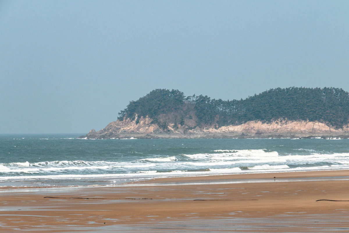
Waves cross a sandy beach with a rocky, tree-covered headland across the water.

Yellow Sea from Mallipo Beach, photographed by Craig Rohn on 5 February 2015. A historical view of the park’s coastal landscape.

“Yellow Sea from Mallipo Beach” by Craig Rohn (craig.rohn), Flickr, CC BY-SA 2.0. Unchanged original; no crop, resizing or re-encoding. · Creative Commons 1 · Creative Commons 2

Walks and routes

Mongsanpo to Cheongpodae: a shorter Solmoraetgil outing

KNPS lists this first section at 6 km one way and 1 hour 30 minutes. Begin at Mongsanpo visitor support centre and follow Solmoraetgil signs toward Cheongpodae through pine woodland and sandy paths. The wider route passes village and wetland scenery. Stop at Cheongpodae unless you have planned the onward walk: the complete Solmoraetgil to Deureuni Port is listed by KNPS at 16 km and 4 hours. For an unhurried first visit, leave more time than the published pace and settle the return transport first.

Sandy surfaces can be tiring, and the full route includes small hills and road or embankment sections. This is a walking option, not a verified step-free trail.

Mongsanpo to Cheongpodae: a shorter Solmoraetgil outing

Cheonsagil and Gijipo: the boardwalk choice

The designated Cheonsagil boardwalk is 1,004 m long and links the Sambong accessible-parking side with Gijipo. Treat that figure as the named boardwalk length, not a complete visit or guaranteed round trip. At Gijipo, use the open nature-trail area for views of the beach and dunes, then return along the confirmed accessible route. You can keep the outing short without committing to the whole Noeulgil.

The ramp/deck approach and accessible public toilet beside Gijipo visitor support centre are documented. Ask about damaged boards, sand accumulation, gradients and the precise start-to-finish route for your mobility needs.

Cheonsagil and Gijipo: the boardwalk choice

Noeulgil: Baeksajang Port to Kkotji Beach

This is the more ambitious option: 12 km one way, with a KNPS estimate of 3 hours 40 minutes. The signed route passes Gijipo, Duyeo viewpoint, Batgae village and Bangpo viewpoint before Kkotji. Pine-backed shore scenery gives way to more demanding hills farther south. Finish with a settled plan for getting back; the route name’s association with sunset is no reason to leave an unfamiliar walk until dusk.

The complete route includes hills and ordinary-road sections. The accessible boardwalk near Gijipo does not make the whole route accessible.

Noeulgil: Baeksajang Port to Kkotji Beach

A relaxed Gijipo half-day

Arrive with the tide, weather and control checks already done. Confirm the open boardwalk at the visitor support centre, take a short out-and-back on the usable path, and stop for dune interpretation and shore views. Have lunch after the walk. If you add sunset, choose a nearby legal viewpoint and a clear return route rather than extending onto unfamiliar tidal ground. Allow about 2–3 hours for the nature visit, excluding your meal and transfers.

A walking-focused day

Set up your return from Cheongpodae before leaving Mongsanpo. Walk the signed 6 km section at an easy pace, with water and snacks, and spend your extra time in the woodland and at permitted viewpoints. A separate guided session or meal can fill the rest of the day. Do not add the remaining 10 km to Deureuni simply because it continues on the same named route.

Things to try

Join a tidal-flat interpretation session

KNPS lists a “Living Tidal Flat Story” programme meeting at Sambong car park and lasting up to 80 minutes. The session is fitted to the tide and requires a booking check; contact the park on 041-672-9738 for the current date, start time and equipment advice. Arrange this before building the day around it.

Photograph the changing shore

Choose a safe viewpoint reachable by the marked path and let the tide and light change the composition. At high water, waves and headlands may dominate; at lower water, wet sand can add foreground reflections. Keep tripods out of the passageway, protect equipment from spray and leave before poor visibility makes the return awkward.

A sheltered alternative

Ask whether the Taeanhaean learning centre is open and which exhibits or activities are available on your date. Check before driving there, especially after a temporary-closure notice. If the weather warning affects travel as well as the beach, postpone the outing rather than trying to rescue the itinerary with another exposed stop.

Wildlife and habitats

Pines along the coastal paths

Japanese black pine is the gomsol named in the official coastal-walk descriptions. Notice how the woodland provides a sheltered contrast to the open beach. These are managed coastal stands; do not assume that every tree is naturally established.

Plants of the Gijipo dunes

Sea bindweed is among the plants documented at Gijipo’s dunes. Look from the boardwalk and use the local interpretation signs to put a name to plants near the path. Do not step into vegetation for a closer photograph or expect every species to be visible in every season.

Seaside pea

Seaside pea is also recorded in the Gijipo dune vegetation. Its presence is a reason to keep to the designated route: apparently empty sand can support small coastal plants. Enjoy the plant community as a whole, whether or not anything is in flower.

Stories and discoveries

Why the dunes are fenced

Dunes are a living buffer between shore and land. Wind moves beach sand inland, where plants and obstacles help it accumulate. The sand-catching structures around Gijipo help that process. Use the boardwalk to see the landscape at close range without flattening the vegetation or making a shortcut through recovering sand.

When to visit

Spring and autumn

These are sensible seasons for a walk-first itinerary. Flexible layers work better than judging the day from a warm car park. Leave time for breaks and photographs, and use the actual forecast to decide how much exposed coast to attempt. An October visit also needs the current sector-specific reservation check.

Summer and winter

In summer, plan the exposed portions outside the hottest part of the day and keep swimming separate from the walking plan. In winter, favour a short shore-and-woodland visit with shelter close by. Neither quiet beaches nor a closed seasonal beach facility should be read as permission to enter the sea.

Getting there and practical advice

Visitor support and camping

Use the Mongsanpo or Gijipo visitor support centre for local route advice. Overnight camping is a separate plan: check named KNPS campsites, available dates and the applicable charges in the reservation system. Do not assume that a pine grove or empty beach permits a tent. Carry what you need for the walk rather than counting on refreshments at every intermediate point.

Choose a beach gateway before choosing transport

Navigate to the specific visitor support centre or beach you intend to use, rather than the national-park office in Taean town. For a one-way coastal walk, verify both the outward journey and the final return service before starting. Current local bus timetables and last departures need a date-specific check; if they do not suit the walk, shorten it or arrange a return ride. Drivers should use designated parking and allow for a different arrival and finishing point.

Plan the whole accessible journey

When asking about Gijipo, check the link from your parking place or drop-off to the deck, the distance you want to cover, turning space and the toilet. A published accessible feature does not settle every part of the journey. Rain can make decking slick and wind can make a short exposed outing uncomfortable, so keep a shorter fallback and an easy way back.

Tides set the limits

Check the tide for the exact place and date, then follow on-site warnings and local instructions. Do not walk around a headland, into a sea cave or toward an island just because the way looks exposed. KNPS specifically warns against using shore-level paths at high tide. For a permitted tidal-flat activity, go with companions, wear suitable protection and agree a conservative return plan. Avoid night-time foraging, and keep children with an adult. Tide predictions help planning; they do not certify a route as safe.

Visitor information

Before you set out

Checked 18 October 2026: the KNPS control notice identifies a 1.1 km closure between Jangsam-po Beach and Baramarae Beach for the Anmyeondo tourism-development project, scheduled through 31 December 2030. Recheck this notice and any newer controls before travel. A separate reservation applies to the 1.4 km Hakampo visitor support centre–Guryepo Beach section from 1–31 October 2026: 09:00–16:00, last admission 15:00, with a daily limit of 350. Book through KNPS if that is your destination. The advertised learning-centre closure dates of 13–14 October have passed; confirm its current opening before going.

Sources and useful links

Wildlife you might spot

3

Each card links to a full Explore page with photos, traits, and fun facts.

We are still adding species preview cards for this place.

Snap map for this place

Start with the big picture, then zoom in to explore individual wildlife observations around this place.

Loading map…

Good to know before you go

Check the park’s control notices and your exact sector before leaving; a route page is not an opening guarantee.

Read the local tide forecast and on-site warnings before approaching the foreshore.

Stay on designated paths and boardwalks; keep off dunes and behind restoration fencing.

Carry drinking water, a snack, sun protection and a windproof layer.

Arrange the return journey before starting a one-way walk, especially if you depend on a bus.

Leave shells, plants and animals where they are; a visible tidal flat is not permission to collect.

Frequently asked questions

Choose Gijipo if a short, flexible visit and boardwalk access matter most. Choose Mongsanpo–Cheongpodae if you want a substantial one-way woodland-and-coast walk and can arrange transport back. Save the full Noeulgil for a day with enough walking time and settled conditions.
Some sectors and activities do. For 1–31 October 2026, the Hakampo–Guryepo section has a specific reservation requirement. Campsites and guided sessions have their own arrangements. Check the exact trail or activity in the KNPS reservation service rather than assuming one rule applies to every beach.
Do not treat an exposed crossing as a walking route. Water can cut off the return, and local access restrictions still apply. Follow the marked landward path and any ranger instructions; ask locally before considering a tidal-flat activity.
A single-sector visit is more satisfying. Beaches and trail gateways are spread out, and the national park also includes offshore areas. Choose one walk, one meal stop and, if conditions suit, an easily reached sunset view.

Recent snaps at this place

Recent snaps will appear here as new observations are added.

View all ›

Take the discovery with you

Exploring Taeanhaean National Park?

Identify the wildlife you spot, learn as you go, and keep a collection of the adventure.

  1. 1Spot it
  2. 2Snap it
  3. 3Keep the discovery
