Snappit logo
Snappit
Get App
Generic illustration, not a photograph of this venueIllustration
ParkKR

Taebaeksan National Park

Start by choosing a gateway.

About

Start by choosing a gateway. Danggol is the most useful introduction, with the Sky Observatory, visitor facilities and a valley trail. Geomryongso lies in a separate northern sector, while Yuilsa is a starting point for the climb to Janggunbong and Cheonjedan. The wildflower country around Geumdaebong and Daedeoksan has its own controlled-access arrangements. These are parts of one park, but they are not stops on a single casual stroll. Enhance your adventure: download the Snappit app to identify the local species you encounter.

Taebaeksan became a provincial park in 1989 and Korea’s 22nd national park in 2016. Its cultural significance is much older: the high mountain was a place of rites to heaven. Cheonjedan is a group of three stone altars, rather than a single summit monument, and the tradition of ceremonies on National Foundation Day, October 3, continues.

What to do here

For an easy first day, explore Danggol’s low-level Sky Observatory and leave time for the nearby Coal Museum or a short valley walk. Choose Geomryongso instead if flowing water and forest are your priority. If you want the stone altars and high-mountain yews, arrive equipped for the Yuilsa–Cheonjedan hike and organize your return transport before setting off.

Seasonal info

Check the [park’s access notice](https://www.knps.or.kr/front/portal/safe/acsCtrDtl.do?menuNo=8000340&parkId=122200) and [entry-time table](https://www.knps.or.kr/portal/main/contents.do?menuNo=8000198&parkId=122200) before traveling and again on the morning of your walk. Fire prevention, heavy rain, snow and wind can change the plan. A general reopening notice does not override a reservation-only sector or a closed individual facility.

Accessibility

Danggol’s Sky Observatory was designed as a low-level accessible outing, including use by wheelchair and stroller visitors. That provision does not extend to the mountain trails. Geomryongso has earth, rock and wooden steps; the park specifically warns that wheelchair and stroller use is difficult there.

Don't miss

1

The Sky Observatory at Danggol, a gentler way to enjoy the mountain landscape.

2

Cheonjedan’s stone altars and the high ridge reached on a prepared mountain walk.

3

Geomryongso’s cold spring, mossy rocks and flowing headwaters.

4

The controlled Geumdaebong–Daedeoksan wildflower sector.

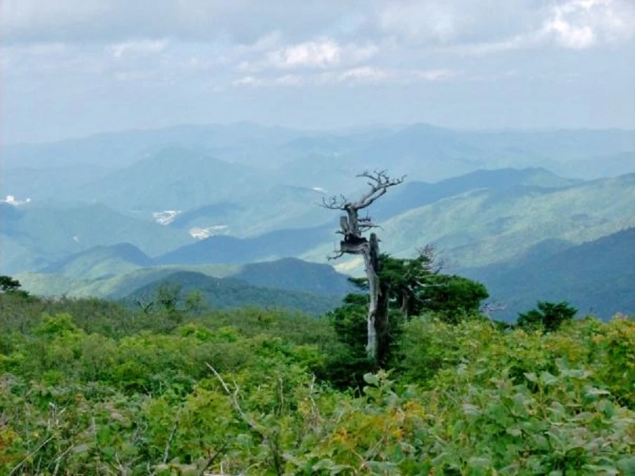
A weathered tree rises above green mountain vegetation, with layered blue-green ridges under a pale cloudy sky.

A weathered tree above Taebaeksan’s layered ridges, photographed in July 2014. This historical image does not show current conditions.

“Taebaeksan” by Kyle (Kjmagnuson), CC BY 2.0. Source: Flickr. No changes. · Creative Commons 1 · Creative Commons 2

Walks and routes

Danggol: choose a low-level visit or the valley trail

Begin at the Danggol visitor area. The Sky Observatory offers a view from a 33 m tower reached by a gradually climbing accessible facility. For a separate woodland walk, the official Danggol course follows the valley from Danggol Plaza to Banjae: 2.0 km and about one hour one way. Returning from Banjae is a sensible shorter mountain outing; continuing through Mangyeongsa toward Cheonjedan commits you to the high mountain.

Use the observatory’s designated accessible approach if step-free travel matters. The valley trail is an uphill hiking route, not an extension of the accessible deck.


Danggol: choose a low-level visit or the valley trail

Geomryongso: the short headwater walk

Walk from Geomryongso parking through the forest to Sesim Visitor Support Center, then follow the signed spring route over Sesimgyo. Wooden steps and viewing decks protect the final approach to the water. KNPS gives 1.5 km and 35 minutes one way; return along the same open route. Stay on the viewing structures rather than scrambling over the wet rocks.

Much of the path is earth and stone, with a sloping final section and steps. This is a relatively short walk, but not a step-free route.

Geomryongso: the short headwater walk

Yuilsa–Janggunbong–Cheonjedan–Danggol

This is the classic high-ridge choice: climb from the Yuilsa side through the yew country to Janggunbong (1,567 m), continue to Cheonjedan, then descend by Banjae toward Danggol Plaza. KNPS publishes 7.5 km and 4–4½ hours for this point-to-point course. Budget extra time for rests, the altars and difficult footing. It is not a 7.5 km return walk to the Yuilsa car park.

Expect sustained ascent and descent, uneven mountain surfaces and exposed high ground. This route is unsuitable for wheelchairs or strollers.

Yuilsa–Janggunbong–Cheonjedan–Danggol

Dumundongjae–Bunjuryeong–Daedeoksan–Geomryongso

For a flower-focused hiking day, use the exact itinerary offered by the reservation system. Its Daedeoksan listing runs from Dumundongjae through Bunjuryeong and Daedeoksan to Geomryongso Visitor Support Center, at 8.7 km and four hours. The separate Geumdaebong course description includes a steep climb to that peak; do not assume every booking includes this extra section. Finish-to-start public transport is not provided, so a one-way walk needs a taxi or arranged transfer.

The long route includes steep ground near the peaks and wooden steps on the Daedeoksan descent, which can be slippery when wet.

Dumundongjae–Bunjuryeong–Daedeoksan–Geomryongso

Manhangjae–Hambaeksan

For another high-mountain day, follow the signed course from Manhangjae to Hambaeksan Giwondan and onward to Hambaeksan, listed by KNPS as the park’s highest peak at 1,572 m. The official sections are 2.0 km in one hour, then 1.1 km in 30 minutes: 3.1 km one way when combined. Plan the return separately. Starting from a high road pass reduces the climb, but the final ascent remains a mountain trail.

There is an uphill final section and exposed summit terrain. Do not mistake road access to Manhangjae for vehicle access to the summit.

Manhangjae–Hambaeksan

Baekcheon Valley: a separate Bonghwa outing

Approach from Bonghwa for the cold-water valley and its protected fish habitat. Keep a gentle visit to the open lower valley and turn back when ready. The official mountain route continues 5.1 km to Munsubong, with a published time of 2½ hours one way, then goes farther toward Cheonjedan. That continuation is a substantial hike, not an easy add-on to a streamside visit.

Do not assume a continuous wheelchair-accessible valley route. Ask the Baekcheon visitor staff about the currently suitable lower section before choosing a turnaround.

Baekcheon Valley: a separate Bonghwa outing

A first visit with an easy pace

Spend the morning around Danggol and the Sky Observatory. Pause for a meal, then choose either a short open valley walk or the Coal Museum according to the weather and your group’s mobility. Keep the summit for another day if anyone is unsure about a sustained climb.

A mountain day with a clear finish

Start early enough for your chosen open route, allowing for your own pace rather than aiming at the latest legal entry. The Yuilsa–Danggol traverse works best with transport arranged at both ends. Carry the park’s course information offline and agree on a turnaround time before you climb.

Things to try

Photograph the landscape without rushing the summit

A weathered tree against layered ridges is a characteristic Taebaeksan composition, but you do not need to chase a sunrise to enjoy the landscape. On a clear day, leave time for the accessible observatory or safe trail viewpoints. On the mountain, keep the path clear and put warm clothing back on during long photo stops.

Make the wildflowers the main event

In the permitted season, a booked Geumdaebong–Daedeoksan outing rewards an unhurried pace. Photograph flowers from the trail and carry a close-focusing lens rather than stepping into vegetation. Ask about an available ranger interpretation program; old program announcements are not a current timetable.

Taebaek Coal Museum at Danggol

The Coal Museum explains geology, coal extraction and life in the mining region. Its regular hours are 09:00–18:00, with entry until 17:00; Mondays are normally closed. Individual adult admission is listed as KRW 2,000. It is a separately operated attraction, so check its own notices rather than the park’s trail status.

Important access warning for autumn 2026

The museum’s lift-replacement notice says the lift is unavailable from October 13 through late November 2026. Visitors who cannot use stairs, including many wheelchair and stroller users, may find a museum visit difficult. Call 033-552-7720 before relying on it as your indoor alternative, and check for a completion update.

Wildlife and habitats

Yews (Taxus genus)

The yew grove near Janggunbong is one of the mountain’s defining sights. KNPS identifies the local tree as Taxus cuspidata. Look from the marked trail at the contrast between evergreen foliage, rugged trunks and standing dead wood; do not climb on the trees or leave the path to frame a photograph.

Cold-water life in Baekcheon Valley

The park highlights the cold-water fish known as yeolmokeo, listed by KNPS as Brachymystax lenok tsinlingensis, in Baekcheon Valley. Come to understand the habitat rather than expect a fish sighting: keep out of the water, do not feed or disturb wildlife, and let staff point out any permitted viewing area.

Stories and discoveries

Three altars, one name

Cheonjedan comprises Cheonwangdan, Janggundan and a lower altar. Their relationship matters more than ticking off a summit marker: together they preserve a landscape of worship. Treat ongoing rites respectfully, give participants space and avoid standing on the stonework.

The dragon and the spring

Geomryongso’s water emerges through limestone. Local tradition tells of an imugi, a dragon-like creature, traveling upstream and training here to become a dragon. The story gives the twisting watercourses their imaginative character; the spring and worn rock are the physical features you can see from the decks.

When to visit

Spring and summer

Check fire-control notices before a spring flower trip. Early in the wildflower reservation season, the Geumdaebong direction may still be restricted. Summer forest shade can be welcome, but heavy rain and typhoon warnings can close the routes; postpone a valley walk when access is restricted rather than walking around a barrier.

Autumn and winter

Autumn days shorten quickly, so leave a generous descent margin. For Danggol and Yuilsa, the published entry window is 03:00–16:00 in April–October and 04:00–15:00 in November–March. Geomryongso-direction entry has later cutoffs, but other directions from the same sector differ. Read the exact gate row and return before darkness; reservation rules can be more restrictive.

When snow is the attraction

Snow-covered yews and rime are a reason people travel here, but they are weather-dependent. Expect frozen paths and much colder conditions on exposed ridges than at the gateway. Carry a headlamp as emergency equipment, not as a reason to ignore entry restrictions, and shorten the route if progress is slow.

Getting there and practical advice

Danggol’s Sky Observatory

The opening announcement describes an 890 m accessible facility including the sky trail, with an average gradient of 1:16. This is the published facility length, not a measured return walk from every parking space. Taebaek’s 2026 visitor map lists free admission and 10:00–17:00 opening. Confirm weather closures, the approach from your parking place and any assistance needed before arrival.

Trailhead essentials

The KNPS Danggol directions identify Danggol Plaza in Sodo-dong 180 and Danggol No. 1 parking in Sodo-dong 326. Use the named gateway in navigation rather than the general national-park office. Geomryongso’s official route lists a toilet near the start and resting places along the walk. Bring your own water; spring scenery is not a drinking-water assurance.

Arriving through Taebaek

Use Taebaek as the transport base for Danggol or Yuilsa. KNPS describes local bus connections from Taebaek Intercity Bus Terminal to both gateways. Check the actual departure and last return for your travel day; bus frequencies and journey times are not guaranteed by a general route page. Park enquiries: 033-550-0000.

The northern gateways need a return plan

KNPS’s Geomryongso directions currently advise taking a taxi from Taebaek Intercity Bus Terminal rather than relying on a direct bus. The Daedeoksan booking page also warns that its one-way traverse has no public-transport link between the ends. Arrange a pickup and meeting point before entering the trail; do not count on a taxi waiting at a remote car park.

Choose the facility, not just the park name

For wheelchair or stroller users, ask specifically for the Sky Observatory’s accessible approach, the closest suitable parking and an available toilet. An average gradient does not establish that every approach is comfortable for every chair or user. The observatory’s provision should not be generalized to Geomryongso, the Banjae climb or the summit routes.

Sources and useful links

Wildlife you might spot

1

Each card links to a full Explore page with photos, traits, and fun facts.

Snap map for this place

Start with the big picture, then zoom in to explore individual wildlife observations around this place.

Loading map…

Good to know before you go

Carry a warm layer, waterproof shell, water and food even when Taebaek city feels mild.

In snow or ice, use suitable winter footwear and traction, and turn back before the weather or footing exceeds your experience.

Keep to open trails and boardwalks. Do not step into flower beds for photographs.

Arrange the pickup before choosing a route that finishes at a different gateway.

Leave the spring, streams, trees and stone altars undisturbed; take rubbish back out.

Frequently asked questions

Yes. Choose Danggol’s Sky Observatory for a low-level visit, or Geomryongso for a separate short walking outing. The latter still involves uneven ground and steps.
The Geumdaebong–Daedeoksan controlled sector has a reservation system. Do not confuse it with the ordinary Geomryongso spring walk, even though the routes meet near Sesim. Confirm the exact course and date before booking.
Popularity does not remove the exposure to cold, ice and poor visibility. If you lack winter mountain experience, keep the day at an open low-level facility or join an appropriately equipped, experienced group on a suitable route.
The published Yuilsa–Danggol route finishes at another gateway. Arrange a taxi or other transfer, or ask the park about a suitable same-start return plan and its current conditions.

Recent snaps at this place

Recent snaps will appear here as new observations are added.

View all ›

Take the discovery with you

Exploring Taebaeksan National Park?

Identify the wildlife you spot, learn as you go, and keep a collection of the adventure.

  1. 1Spot it
  2. 2Snap it
  3. 3Keep the discovery