Snappit logo
Snappit
Get App
Generic illustration, not a photograph of this venueIllustration
ParkKR

Taejongdae Park

Taejongdae is where a Busan city day can become a coastal walk.

About

Taejongdae is where a Busan city day can become a coastal walk. The wooded road keeps the sea hidden for stretches, then opens towards rock walls and passing ships. The observatory is the easiest place to make the water the main event; the lighthouse adds a more demanding descent and a closer sense of the cliff landscape. Taejongsa offers a quieter change of pace, especially outside the summer flower season.

Come for the combination rather than a checklist. A good visit might mean the full circuit with one carefully chosen descent, or a shorter outing that leaves plenty of energy for the return. This is a scenic recreation area and a geosite within Busan’s geopark, not a national park. Its exposed lower shore should never be treated as a playground or a shortcut. Be ready to snap and learn! Get the Snappit app to identify any nature species you find here.

The name Taejongdae is traditionally linked to Silla’s King Taejong Muyeol and stories of archery and enjoyment of the coastal scenery. Treat these as the site’s inherited stories, rather than a precisely documented royal itinerary. The landscape became a nationally designated Scenic Site in 2005. Yeongdo Lighthouse began operating in 1906, adding a working maritime landmark to a coast long valued for its scenery.

What to do here

Choose a road walk, visit the observatory and decide separately whether the lighthouse stairs suit your group. Add Taejongsa for its temple setting and cultivated hydrangeas in early summer. The cliff geology is worth a stop even when haze hides the distant horizon.

Seasonal info

Summer brings Taejongsa’s flower displays as well as humidity and rain. Winter can offer crisp sea views, but wind makes exposed stops feel much colder than the sheltered entrance. A clear forecast does not guarantee safe conditions beside the water.

Accessibility

The circuit road and the lighthouse descent are very different outings. Gradients still matter on the road, while the lower lighthouse approaches involve stairs. Visitors who need step-free transport should confirm the replacement bus’s boarding arrangements before travelling.

Don't miss

1

The broad sea view from Taejongdae Observatory

2

Yeongdo Lighthouse and the stepped approach to its coastal setting

3

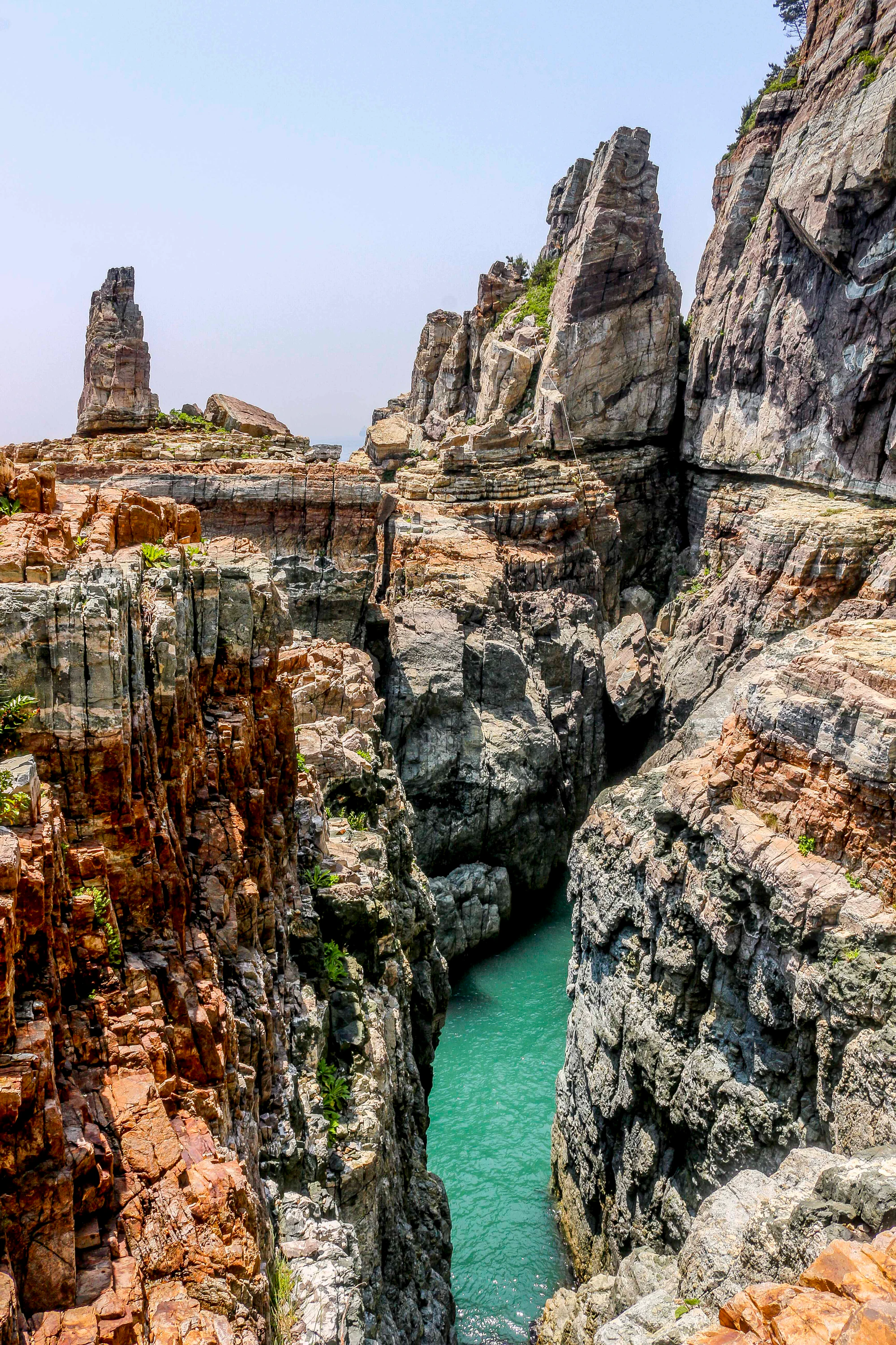
Layered rock walls shaped by ancient deposition and later wave erosion

4

Woodland walking and Taejongsa’s cultivated summer hydrangeas

Tall layered rock faces and narrow stone spires surround a cleft of turquoise seawater, with sparse greenery along the upper rocks.

Taejongdae’s layered coastal rocks above a narrow inlet, photographed on 25 May 2016 by Juliana Chong. This historical view illustrates the landscape; it does not establish that the pictured rock edges are safe or open to visitors.

“태종대” by Juliana Chong, Flickr, CC BY 2.0. Supplied description: “Sedimentary. Taejongdae, Busan, South Korea”. Unchanged original; no crop, resizing or re-encoding. · Creative Commons 1 · Creative Commons 2

Walks and routes

The full headland circuit

Start at Danubi Plaza and follow the signed circuit towards the observatory, lighthouse stop and Taejongsa before returning to the plaza. The operator publishes a road circuit of about 3.8 km: 1.7 km to the observatory, 200 m to the lighthouse stop, 600 m to Taejongsa and 1.3 km back. These are stop-to-stop road distances; lighthouse stairs and other detours add distance and effort. Allow about 2–3 hours with pauses, longer for a descent. This is the best choice if you enjoy the wooded stretches as much as the viewpoints. Keep clear of internal vehicles and use the designated pedestrian space. At each optional descent, decide whether you still have enough energy for the climb back.


The full headland circuit

Observatory first, with an optional lighthouse descent

For a simpler outing, follow the observatory side of the circuit from the plaza, enjoy the view and retrace your steps. Allow around 1½–2 hours rather than treating this as a quick look from the gate. If everyone is comfortable continuing, the lighthouse stop is a short road section beyond the observatory; the stairs below it are a separate commitment. Walk down only as far as the open route and your group’s ability allow. Turning back at the top is a sensible way to retain the sea views without adding a steep return. Do not try to join the lower rocks into an improvised coastal loop.

Observatory first, with an optional lighthouse descent

A bus-assisted visit

When the replacement bus is operating, use it to save the long approach and concentrate on one or two stops. Start with the observatory, then choose either the lighthouse area or Taejongsa according to mobility and interests. This is especially useful in humid weather, but it is not a guaranteed no-walking visit: allow for queues, the walk from each stop and any stairs you choose. Ask about reboarding and the last usable return before getting off. If your group cannot comfortably walk back, do not set out until staff have confirmed an appropriate return option.

A bus-assisted visit

An unhurried half-day

Arrive with enough time to check the entrance noticeboard before choosing transport. Make the observatory your first main pause. Continue to the lighthouse only if the stairs and conditions suit everyone; otherwise keep the upper road as your route. Finish with a temple stop if you still have time and energy, then return without depending on the last bus.

Things to try

Coastal photography

Use the observatory for a broad seascape and the permitted lighthouse approach for a different relationship between tower, trees and rock. Haze can simplify the horizon; side light can make rock layers easier to distinguish. Keep camera straps secure in wind, leave passage on narrow stairs and choose a safe position before framing the shot.

A guided geology outing

The city lists a roughly 90-minute Taejongdae interpretation programme. If rocks are your main interest, consult the official programme page for bookings and confirm the day’s meeting point, language and accessible route. A guide’s explanation can make more sense of the cliff forms than attempting to identify every feature alone.

When the coast is not the right outing

If rain is light and there is no warning or closure, a short upper-road walk may be enough, with a turnaround before slippery stairs. In strong wind, heavy rain or high surf, postpone the headland visit. Do not use a cave, the foot of a cliff or a small shoreline structure as shelter. Choose an indoor activity elsewhere in Busan and return when conditions allow you to enjoy the park comfortably.

Wildlife and habitats

Japanese black pine

Japanese black pine (Pinus thunbergii) is a documented part of Taejongdae’s coastal woodland. Studies in 2007 and 2022 describe its prominence in the forest canopy. Enjoy the wooded sections as part of the visit, rather than hurrying through them between sea views.

Hydrangeas (cultivated garden plants)

The flower display around Taejongsa is cultivated. Enjoy its different colours and shapes from the paths without stepping into the planting or picking blooms. Colours and flower shapes vary across the collection, making this a garden stop rather than a search for wild plants.

A forest that is changing

The 2022 survey describes a shift towards broadleaved trees alongside the black pines, with salt exposure, disease and changing growing conditions among the pressures on the woodland. That makes the forest more than a backdrop to the cliffs. Stay on established paths and avoid trampling roots or low vegetation while looking for a better camera angle.

Stories and discoveries

An old lake, a younger coastline

The cliffs began as sediment laid down in a lake during the late Cretaceous. Later changes and marine erosion exposed and reshaped the rock into the coastal scene seen today. Some bands remain fairly orderly; other structures preserve deformation, fractures and intrusions. You do not need geological vocabulary to enjoy the contrast between the layered rock and the water, but the city’s geosite guide helps explain what those patterns mean. Look from permitted paths and viewpoints; leave rock fragments and vegetation in place.

A lighthouse with a working history

The lighthouse’s story reaches back to 1906, when it was established as Busan’s first staffed lighthouse. Its presence gives the visit a maritime focus beyond the scenery. View the tower and coast from public areas, and treat any exhibition room or gallery as an optional extra whose opening needs checking on arrival.

When to visit

Spring: make walking the priority

Choose a mild day for the full circuit, with time to move between sheltered woodland and exposed viewpoints. Flowering trees can add interest, but exact bloom timing varies. Carry a layer that is easy to put on when you leave the trees, and shorten the exposed stops if the wind is tiring.

Summer: flowers with a slower pace

Taejongsa is a well-known cultivated hydrangea stop, generally around late June and July. Bloom peaks and event dates vary, so check the current announcement if flowers are the reason for your trip. Heat and humidity make the stairs more demanding. Start early, drink regularly and take a shorter route in oppressive weather; heavy rain is a reason to postpone the cliff outing.

Autumn: leave room for the views

A dry autumn day suits a longer walk and leisurely viewpoint stops. Keep the itinerary flexible: a hazy horizon does not spoil the forest, while a windy afternoon may make the observatory a brief stop. If using internal transport, check the current seasonal arrangement rather than last summer’s schedule.

Winter: prepare for exposure

The wooded approach may feel sheltered before you reach the sea. Bring warm layers and gloves if you intend to linger with a camera. Make the most of daylight and skip any wet or icy stair section. Winter is a good reason to keep the temple or lighthouse optional rather than trying to force the full outing.

Getting there and practical advice

Entry, opening hours and essentials

KTO lists park admission as free, with access 04:00–24:00 from March to October and 05:00–24:00 from November to February. Those broad park hours do not guarantee access to the coast, buildings or transport. A daylight visit is the practical choice for this guide. Parking and toilets are listed, but budget separately for parking and do not assume a particular shop will be open. Bring drinking water before beginning the circuit.

Arriving by car

Aim for the entrance parking arrangements rather than expecting to drive between viewpoints. Internal vehicle access is controlled and can change with works or operating conditions. Confirm any disability-related access arrangement in advance. Leave enough time after the walk to reach your next destination through city traffic.

Getting to the entrance

Use Taejongdae or Taejongdae Hot Spring as your bus destination and check a current Busan journey planner for the stop serving your starting point. BTO lists city buses 8, 30, 66, 88, 101 and 186. Yeongdo is reached by road, so a metro journey still needs a bus or taxi connection. For a taxi, the visitor address is 24 Jeonmang-ro, Yeongdo-gu, Busan. Confirm your return stop before entering, particularly if you are heading to a train or flight later.

The current internal transport arrangement

Checked 18 October 2026: Danubi trains are suspended for safety inspection. BTO’s current visitor page lists a free circuit bus Wednesday–Sunday, 09:30–17:30, with free timed tickets issued from 09:10 and places allocated first come, first served. Monday and Tuesday are rest days, subject to holiday changes; poor weather can stop service. An older July notice gives different hours. Confirm the day’s service at 051-405-8745 or on the operator page before relying on it.

Plan around the actual surface and gradient

The upper circuit is the more flexible starting point, but a paved surface does not remove the uphill effort. Decide your maximum comfortable walking distance before setting out. The lighthouse and lower shore involve stairs, and Taejongsa’s approach includes a steep rise. For a wheelchair, stroller or anyone with painful knees, it may be better to choose one upper stop than to attempt every advertised feature.

Facilities to confirm before arrival

Visit Busan lists accessible parking, accessible toilets, assistance-dog access and free wheelchair loan at the main entrance tourist information centre. Check availability and the route between these facilities for your visit. Its older description of a wheelchair lift on Danubi trains should not be read as confirmation that the temporary buses have the same equipment. Ask specifically about lift or ramp boarding, mobility-device space and whether assistance is available. Do not rely on carrying a wheelchair down the lighthouse stairs.

Sources and useful links

Wildlife you might spot

2

Each card links to a full Explore page with photos, traits, and fun facts.

Snap map for this place

Start with the big picture, then zoom in to explore individual wildlife observations around this place.

Loading map…

Good to know before you go

Check the day’s transport and path notices before leaving central Busan, especially if a member of your group cannot walk the circuit.

Wear shoes with grip. Carry water and a light windproof layer even if the city feels warm.

Keep children close at railings and on stairs. Stop to take photographs rather than walking backwards towards an edge.

Stay out of fenced rock platforms, caves and wave-washed areas. A photograph or an old route description is not permission to enter.

At Taejongsa, give worshippers space, speak quietly and ask before photographing religious activities.

Allow time for the return climb and onward bus. Do not make the final internal service your only way out.

Frequently asked questions

The operator’s page checked on 18 October 2026 says the train is suspended for safety inspection and lists a free replacement circuit bus. Check the current arrangement before you travel; older tourism pages still show train fares and normal schedules.
Yes: make the observatory your main stop and keep the outing on the upper circuit road. That still involves walking or internal transport and does not establish a fully step-free route into every viewpoint facility.
Do not include it as an accessible stop. The city published a rockfall and slope-collapse closure in 2017, and reopening was not verified for this guide. Observe it only from permitted areas and follow current barriers and staff instructions.
Plan it as a headland and viewpoint visit. Rocky shorelines and pebble areas are not a substitute for a managed swimming beach. You do not need to descend to the water to appreciate Taejongdae, and the cliff route is not a continuous shoreline path.

Recent snaps at this place

Recent snaps will appear here as new observations are added.

View all ›

Take the discovery with you

Exploring Taejongdae Park?

Identify the wildlife you spot, learn as you go, and keep a collection of the adventure.

  1. 1Spot it
  2. 2Snap it
  3. 3Keep the discovery