
Snappit logo
Snappit
Get App
Generic illustration, not a photograph of this venueIllustration
ParkKanto, Japan

Tanzawa-Oyama Quasi-National Park

Tanzawa’s forests feel a long way from the city, even though these mountains stand in western Kanagawa.

About

Tanzawa’s forests feel a long way from the city, even though these mountains stand in western Kanagawa. Steep valleys cut into wooded slopes, and the routes leaving Nishi-Tanzawa Visitor Center soon become real mountain walks. For a gentler first encounter, make the center itself your destination and explore the adjacent woodland only as far as suits your group.

Start with a question at the desk: what is worth looking at nearby today? The answer may help you notice a leaf, a rock or a seasonal change you would otherwise walk past. Outside, the adjacent grounds, called 奥中川園地, have rock specimens and a grove of zelkova and mizunara oak. A few unhurried stops here can make a satisfying nature visit without committing to the waterfalls.

The stones tell a surprisingly big story. Tanzawa began as submarine volcanoes far to the south before plate movement and collision helped build the mountains. Look at the outdoor specimens after the displays inside, then compare their colors and textures. Leave stones and plants where they are.

The famous Shimo-dana and Hon-dana waterfalls lie farther up the Nishizawa valley. Repeated bridges, stream crossings, slippery rock and a short chain-assisted section make that a different proposition from the gateway visit. Decide on the hike before you arrive, with suitable footwear, time and current advice. Ōyama’s shrine and cable-car approaches are another part of this large park and deserve a separate day. Explore the grounds like a pro—download the Snappit app to instantly identify animals and plants.

The surrounding prefectural natural park was designated in 1960. Its central area became Tanzawa-Oyama Quasi-National Park on 25 March 1965, and the quasi-national park was expanded in 1985. The two designations still coexist. Far older than either is the landscape itself: its rocks preserve the story of volcanoes, plate movement and collision.

What to do here

Browse the nature displays, ask for the safest short outdoor option and spend time with the rock specimens and trees next to the center. Try a quiet bird-listening pause, then return to the displays with anything you want to identify. Keep the riverbed and waterfall trail out of this short outing.

Seasonal info

Rain can change stream crossings quickly. Land leeches are a spring-to-autumn consideration, especially in damp weather; winter can bring snow or ice and shorter center hours. A clear sky on arrival does not tell you what happened upstream.

Accessibility

For a wheelchair or pushchair visit, call the center to check the entrance, toilets and the exact outdoor paths you can use. The waterfall trail has rough ground, crossings and a chain-assisted section, so it is unsuitable for wheels. Keep your plan centered on the building if outdoor access is uncertain.

Don't miss

1

A small, free visitor center where the mountain landscape starts to make sense

2

Outdoor rock specimens that connect the valley to Tanzawa’s volcanic past

3

Zelkova and mizunara oak in the grounds beside the center

4

A flexible nature stop with no summit or waterfall target to reach

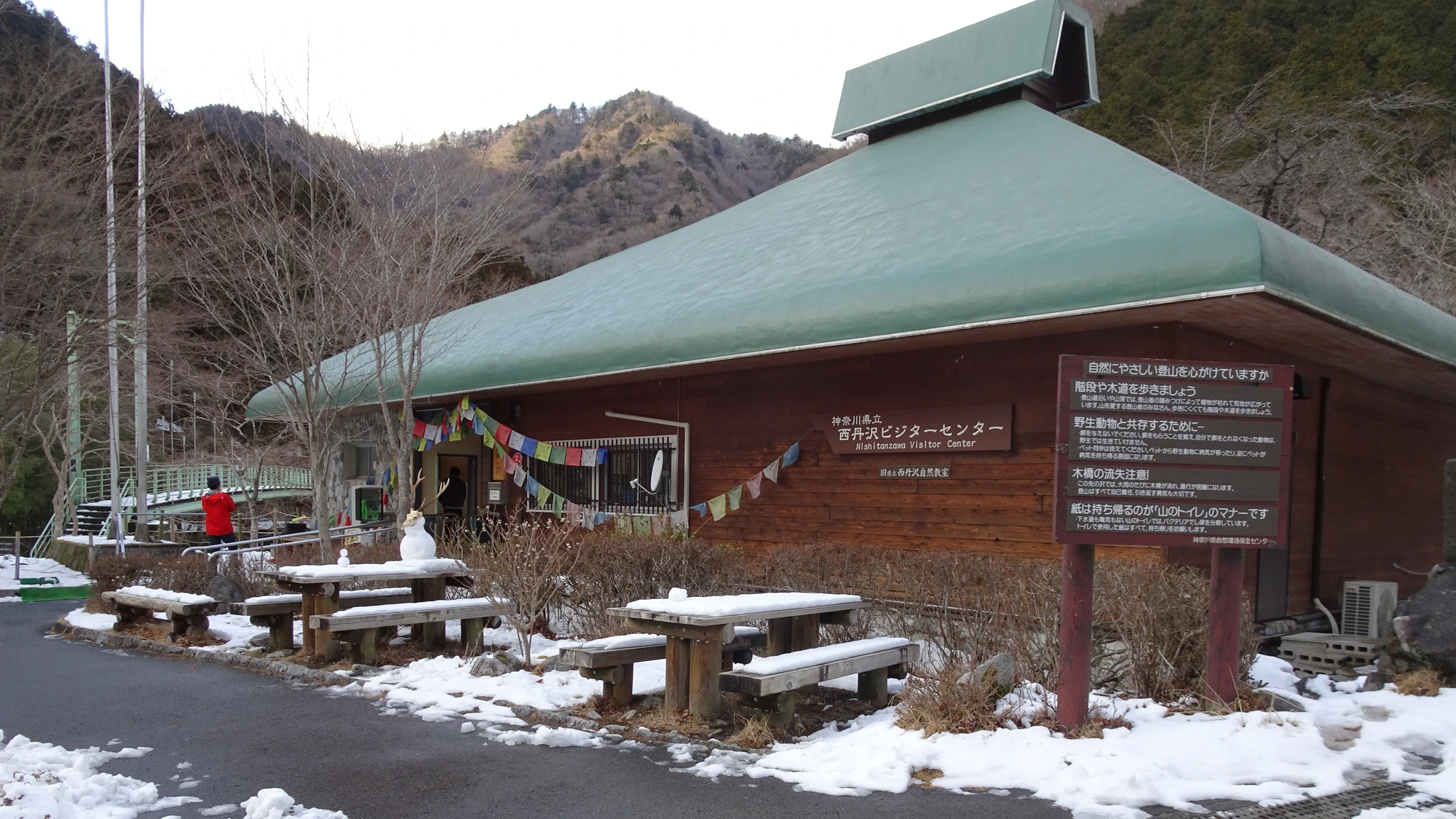
A low wooden visitor-centre building with a green roof, Japanese and English signs, snow-covered benches and wooded hills behind.

Nishi-Tanzawa Visitor Center in February 2023, with snow around the outdoor benches and wooded slopes behind.

NishiTanzawaVisitorCenter.jpg — Azegamaru, CC BY 4.0 (https://creativecommons.org/licenses/by/4.0/). Source: https://commons.wikimedia.org/wiki/File:NishiTanzawaVisitorCenter.jpg. Resized proportionally to a maximum 2000-pixel long edge without upscaling; recompressed as WebP quality 92, method 6. No crop, retouching, added text or colour adjustment. EXIF omitted from derivative; original retained separately as evidence. · Creative Commons

Walks and routes

The short visit: displays, rocks and nearby trees

Begin inside the visitor center. Ask staff which part of the adjacent grounds, called 奥中川園地, is suitable today; visit the rock specimens and make a few stops by the trees before returning to the same building. Give yourself about 60–90 minutes overall. There is no distance target: skip any outdoor section that is muddy, closed or beyond your group’s balance and mobility.

Ask specifically about steps and surfaces between the building, rock displays and grove. Keep a wheelchair or pushchair visit to the areas staff confirm you can reach; do not assume the whole grounds are step-free.

The short visit: displays, rocks and nearby trees

A separate hike: Shimo-dana and Hon-dana waterfalls

The published waterfall course goes from the center over Nishi-Tanzawa Park Bridge and along Nishizawa, taking the branches to Shimo-dana and Hon-dana before returning. An older official bus-company description gives about 4.1 km; the center allows about 2½ hours of walking. Budget 3–4 hours with stops if the route suits your party. Do not continue up toward Azegamaru from the Hon-dana junction.

Expect repeated wooden bridges, uneven and wet rock, stream crossings and a short chain-assisted section. This is for sure-footed hikers, not a pushchair or wheelchair outing. Go with children only if they already cope confidently with this kind of terrain.

A separate hike: Shimo-dana and Hon-dana waterfalls

A compact morning by bus

For a short weekday visit, the timetable checked on 16 October 2026 shows Shin-Matsuda 07:15 → center 08:26, then center 09:50 → Shin-Matsuda 10:59. Start with the building when it opens at 08:30, fit in a small outdoor look and be back at the stop early. Check your travel date and the center’s opening calendar before using these times.

A more relaxed weekend morning

The Saturday/holiday timetable checked on 16 October 2026 shows Shin-Matsuda 07:45 → center 08:56, then center 10:55 → Shin-Matsuda 12:04. That gives time for exhibits, a short outdoor visit and a snack, without setting off up the waterfall trail. Holidays can affect the center’s following closure day.

Things to try

Give the rocks a second look

Choose two outdoor specimens with noticeably different colors or grain sizes. Ask staff what they are and how they fit the mountain’s story. Photograph or sketch them rather than collecting stones.

A tiny woodland notebook

Pick one tree you can see from the open path and sketch its leaf outline and branching shape. Return in another season if you can: the same small patch can be more interesting than a longer walk with no stops.

Listen without chasing

Pause near the center and try separating birds, water, wind and human sounds. Keep to the path and let animals move away; there is no need to approach the river or follow a call into the undergrowth.

An indoor-first visit, or another day

Spend time with the exhibits and ask staff about Tanzawa’s geology. If the rain is light, decide at the desk whether even a short outdoor look is sensible. In heavy rain, storm warnings or road disruption, postpone: the streamside trails and riverbed are poor fallback choices.

Wildlife and habitats

Japanese zelkova

The zelkova in the adjacent grove is a good tree to ask staff to help you identify. Look from the path, compare its leaves with the oak nearby and leave both trees undisturbed.

Oak

The center names mizunara oak among the trees beside the building. Use it for a leaf-shape comparison; recognizing it as an oak is a useful first step before asking about the exact tree.

Sika deer

Sika deer are part of Tanzawa’s wider forest story. Ask how browsing affects new growth and forest recovery; seeing the animal itself is not the aim of this short visit.

Japanese macaque

Japanese macaques are recorded in the wider mountains. If you happen to see them, give them space and keep food packed away rather than trying to draw them closer.

Asiatic black bear

Asiatic black bears belong to this mountain ecosystem. Read the safety advice and current notices before walking; do not seek out bears or approach a cub.

Start with the trees you can examine from the path. The larger animals below belong to the wider Tanzawa landscape and may never appear during a short visit. Watch from a distance, avoid feeding and let the center’s displays fill in the rest of the story.

Stories and discoveries

A mountain story that began underwater

Tanzawa’s geological story began with submarine volcanoes about 17 million years ago. Their northward journey and later collisions help explain why a mountain outing here starts so well with rocks.

A short distance can still mean a serious route

The center calls the approximately 1½-hour return walk to Gōra-sawa-deai an advanced option. In this landscape, a short time on a route list does not make it an easy stroll.

When to visit

Spring and autumn

Use the center’s current nature notes to choose what to look for close by. Bring an extra layer for pauses, and leave a generous margin before dusk rather than trying to squeeze in another trail.

Wet and warm months

The local operator warns of leeches around the center in spring through autumn. Prefectural guidance gives April–November as their activity season, especially June–September and during or after rain. Wear long trousers and socks, use repellent as directed and inspect footwear before boarding the bus.

Winter

Expect the possibility of snow and ice and a 16:00 center closing time from December through March. The nearby trails need winter-specific judgment and equipment; keep a casual visit indoors when footing is poor. Check the bus’s separate winter restrictions too.

Getting there and practical advice

Opening hours and help

Nishi-Tanzawa Visitor Center is free and normally opens 08:30–16:30, closing at 16:00 from December through March. It closes Mondays, or the next weekday when Monday is a public holiday, and 29 December–3 January. Call 0465-78-3940 to check your date or discuss access needs.

Small comforts

The operator lists a baby-changing table, written communication and translation-device or app support. Ask where the toilets are when you arrive and check any specific accessible-toilet requirement before travelling. Bring what you need to eat and drink.

Where to eat

Use the benches in front of the center or in the adjacent grounds in good weather. In rain, ask the office about the corridor benches. Food and drink are not allowed in the exhibition and conversation rooms.

Arriving by rail and bus

The Fujikyu Mobility route links Shin-Matsuda, Yaga, Lake Tanzawa and Nishi-Tanzawa Visitor Center. Allow about 70 minutes from Shin-Matsuda; choose a bus whose destination actually reaches the center. The operator’s current timetable index is the best starting point for both directions.

Mind the return gap

The weekday PDF checked on 16 October 2026 has center departures at 09:50 and then 14:40. The Saturday/holiday PDF has 10:55 and then 14:40. Later afternoon options include 15:40 and 17:05 on both sheets, but finish the outdoor part in daylight and avoid building your plan around a late last service. Check for changes and disruption before leaving.

Winter and driving

The Saturday/holiday timetable marks its 07:15 outward bus from Shin-Matsuda and 08:45 return from the center as suspended in December–February. For driving, the operator directs visitors from National Route 246 through Lake Tanzawa on Route 76. Check road restrictions after severe weather and ask the center about parking; do not assume a space will be available.

Make the indoor visit work first

Explain your chair or pushchair dimensions, transfer needs and toilet requirements when you call. Ask staff to describe the entrance and the short route to any outdoor display you want to see. Allow the answer to shape the visit.

Where the terrain changes

The Nishizawa waterfall route is a mountain path with crossings and a chain-assisted section. It is separate from the flexible visit beside the building; carrying a pushchair onto it is not a useful substitute for an accessible route.

Bear country

Asiatic black bears live in Tanzawa. Check recent local notices, go with others and make your presence known in wooded areas. Avoid dawn, dusk and foggy conditions. If you see a bear, stay calm, do not run or provoke it, and slowly back away while watching it. Keep food and rubbish with you and never feed animals.

Current closures elsewhere in the park

As checked on 16 October 2026, Kurokura Forest Road toward Yūshin remained closed to pedestrians following sediment washout from 3 August. The Gongen-yama–Kōbō-yama section was also closed from 14 October because of bear activity. These are separate areas, not closures of the visitor center, but do not use either as an unplanned alternative.

Weather changes the route

Heavy rain can wash away wooden bridges or damage paths, and reports may lag behind the weather. Ask about the previous days’ rain as well as today’s forecast. Keep out of rising or discolored water and turn back before an unsafe crossing.

Sources and useful links

Wildlife you might spot

5

Each card links to a full Explore page with photos, traits, and fun facts.

We are still adding species preview cards for this place.

Snap map for this place

Start with the big picture, then zoom in to explore individual wildlife observations around this place.

Loading map…

Good to know before you go

Choose your return bus before your outward journey. On the weekday timetable checked in October 2026, departures jump from 09:50 to 14:40.

Ask staff about the grounds, bridges, river levels and bear notices before walking beyond the building.

Use grippy shoes and bring a warm layer, rainwear, water and a packed snack.

Keep children close beside roads and water. Never use the riverbed as a shortcut or wade around a missing bridge.

Wear long trousers and socks in leech season; use a suitable repellent according to its label and check shoes before leaving.

Keep food packed away, do not feed wildlife and take all food scraps and rubbish home.

If choosing the waterfall hike, carry a current walking map and a headlamp, allow plenty of daylight and turn back if the crossings are unsafe.

Leave Ōyama and the currently closed Yūshin access route out of this short gateway itinerary.

Frequently asked questions

Yes. The center and adjacent rock displays and woodland are the recommended short visit. You can stop after the indoor displays if weather or mobility makes the outdoor part unsuitable.
They are a hiking choice for sure-footed walkers. The center gives about 2½ hours for the return route, and its recent report describes repeated wooden bridges, wet rock and a short chain-assisted section. Allow longer for stops and check conditions first.
The visitor center is free. Transport and any separately booked guided program cost extra.
Yes. Take a Fujikyu Mobility bus to Nishi-Tanzawa Visitor Center from Shin-Matsuda Station, or join the route at JR Yaga Station. Use the timetable for your exact day and plan the return first.
Treat Ōyama as a separate visit. Its usual approach is from Isehara Station, on a different side of the mountain area. The Ōyama summit itself is a substantial hike.
The indoor displays can work in light rain while the center and transport are operating, but it is a small facility. Check the return bus before committing to the long ride, and postpone during severe weather or access restrictions.

Recent snaps at this place

Recent snaps will appear here as new observations are added.

View all ›

Take the discovery with you

Exploring Tanzawa-Oyama Quasi-National Park?

Identify the wildlife you spot, learn as you go, and keep a collection of the adventure.

  1. 1Spot it
  2. 2Snap it
  3. 3Keep the discovery
