
Snappit logo
Snappit
Get App
Generic illustration, not a photograph of this venueIllustration
ParkKR

Byeonsanbando National Park

The best first visit gives each landscape room to breathe.

About

The best first visit gives each landscape room to breathe. Inland Naebyeonsan is a place for reservoirs, waterfalls and rocky ridges; coastal Oebyeonsan brings beaches, headlands and sea-worn rock. A gentle temple approach and a mountain circuit can start in the same area, so decide how much climbing you want before following a sign uphill. Along the coast, let the conditions set the plan. A beautiful sunset or exposed rock shelf is never a reason to push beyond a barrier or stay as the sea returns. Enhance your adventure: download the Snappit app to identify the local species you encounter.

The peninsula became a provincial park in December 1971 and was promoted to South Korea’s nineteenth national park on June 11, 1988. Its older cultural landscape remains part of the visit. Naesosa’s Daeungbojeon main hall is associated with a 1633 rebuilding; its carved floral doors reward a slow look from the public visiting area. The park protects mountain, coastal and cultural settings together.

What to do here

Choose one inland walk and one coastal stop. Jikso Falls is the natural first choice for a valley outing; Naesosa suits a shorter forest-and-culture visit. For a hiking-focused day, choose the Naesosa ridge circuit or a planned traverse, with transport arranged before you set off.

Seasonal info

Checked October 18, 2026: KNPS lists the Junggyegyo–Soeppulbawi section as closed from September 1 until safety checks are completed and the restriction is lifted. Other routes still need a same-day check for weather, repairs and seasonal fire controls.

Accessibility

The first part of the Jikso approach offers the clearest documented short option: KNPS describes a nearly level, unpaved route to the Nature Conservation Charter Monument. The waterfall itself requires slopes and steps. Coastal rock platforms and the mountain ridges are unsuitable substitutes for a step-free path.

Don't miss

1

Jikso Falls reached through the inland valley

2

Naesosa’s fir-lined approach and historic main hall

3

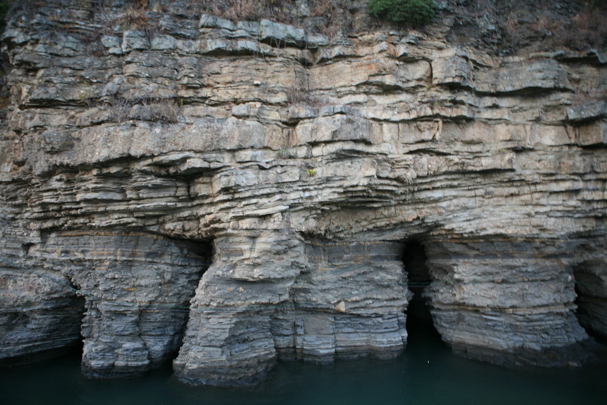
Chaeseokgang’s visible layers of sedimentary rock

4

Gosapo beach and the peninsula’s open coastal scenery

Thin grey rock layers form a coastal cliff, with dark recesses at its base above blue-green seawater.

Chaeseokgang’s layered rock in a historical photograph dated November 1, 2008 by the photographer. The dark recesses are geological features, not suggested places to enter; the image does not establish today’s tide or access.

Photo: [“IMG_1400”](https://www.flickr.com/photos/yembeng/3004632437/in/photolist-5zvwxx) by [yembeng](https://www.flickr.com/photos/yembeng/), [CC BY 2.0](https://creativecommons.org/licenses/by/2.0/deed.en). Original file unchanged. · Creative Commons 1 · Creative Commons 2

Walks and routes

Jikso Falls: the valley walk

Start at the Naebyeonsan visitor-support area and follow the signed route past the Nature Conservation Charter Monument, Jiksobo reservoir and Seonnyeotang toward the waterfall viewpoint. KNPS publishes 2.3 km and 50 minutes one way: the first 1.4 km takes about 20 minutes on mostly level ground, followed by 0.9 km and about 30 minutes of climbing and steps. Return the way you came for the simplest outing. The water, trees and rock make the approach worth enjoying rather than rushing through. Stay behind the viewpoint barriers and keep out of pools. Official Jikso route description.

Naesosa: a short forest-and-temple visit

For a low-commitment inland stop, follow Naesosa’s fir-lined approach into the public temple grounds and return by the same approach. Allow about 1–1½ hours to walk slowly and look at the main hall. This is an editorial visit suggestion, not the KNPS mountain circuit called “Naesosa Course.” Do not follow the uphill Gwaneumbong signs unless you intended to hike. The temple and its approach offer a satisfying visit on their own.

Naesosa ridge circuit: choose it for the climb

The official circuit goes from Naesosa through Gwaneumbong junction, Gwaneumbong and Sebong, then returns to Naesosa. KNPS gives 5.2 km and 3 hours; allow extra time for rests and the temple. The 424 m Gwaneumbong summit is modest in elevation, but the route includes steep slopes, exposed rock and rail- or rope-assisted sections. The descent also needs concentration. Avoid treating it as a casual extension of the fir walk, especially in ice, rain or strong wind. Official Naesosa circuit.

Naebyeonsan to Naesosa: a planned traverse

This route links Jikso Falls, Jaebaegi Pass and Gwaneumbong junction before descending to Naesosa. The published stages add up to 5.9 km and 2 hours 45 minutes; plan a generous half day including rests and temple time. It passes the junction rather than automatically taking in Gwaneumbong summit. Beyond the falls, the character changes to a mountain crossing with rocky sections and a stepped descent. Arrange your return transfer before starting: Naebyeonsan and Naesosa are different trailheads. Official traverse description.

The Gyeokpo coast: drive, then choose short stops

KNPS’s Gyeokpo Course is a coastal drive, not a 17 km footpath. Its Barammotungi–Gyeokpo description links the coast through the Gosapo area. Use it as a framework for separate, legal stops, leaving time to park and walk locally. At Gyeokpo, choose Chaeseokgang for rock layers; add Jeokbyeokgang as a separate coastal visit if conditions and time suit. At Gosapo, the beach and pine backdrop make a gentler pause. No continuous shore-level passage between these places is promised. Official coastal-drive description.

Soeppulbawi: check the named closure first

The mountain’s rock formations are part of the wider park, but the Junggyegyo–Soeppulbawi section is currently listed as closed. Do not plan the published through-route to Junggyegyo or improvise a bypass. Ask KNPS which, if any, approach is open before considering a separate visit. The operator also warns of steep rocky ground and mobile-signal gaps on this course. Current control notice.

One relaxed day

Begin with either the Jikso out-and-back or a Naesosa temple walk. After lunch and a road transfer, choose one coastal area for an unhurried afternoon. Decide the coast stop from current conditions; do not extend your inland walk simply because you hope the sea will become accessible later. Leave enough margin for parking, return transport and a weather change.

Two days with more walking

Use the first suitable hiking day for the Naesosa circuit or the inland traverse, then keep the second day for Gyeokpo, Jeokbyeokgang and Gosapo. Swap the order when mountain or marine conditions favour it. This gives you room to stop for the temple and geology without making a tide-dependent shore visit the final compulsory item of a long hike.

Things to try

Read the coast in layers

Chaeseokgang exposes sedimentary layers associated with an ancient lake environment, subsequently cut by the sea. Look for changes in layer thickness and texture from an authorised viewing position. The contrast with the volcanic rock at inland Jikso Falls gives the two halves of the trip a useful geological connection. You do not need to enter a recess or climb a cliff to appreciate it. Chaeseokgang geology.

Keep the sea visit flexible

Before approaching the shore, ask about the tide, swell, wind and any local access restriction. In fog or rough conditions, stay back on an open landward route or postpone the stop. Never cross a barrier, shelter beneath an overhang, or follow other visitors into a cave because a photograph makes it look inviting. Treat Haseom as a view from shore rather than an unplanned tidal crossing. Coastal access can change while you are taking photographs.

When the weather changes

Ask whether the park visitor centre’s indoor displays are open, or shorten the day to a permitted temple visit if conditions there are suitable. During strong wind, heavy rain or thunderstorms, do not use cliffs, caves, forest or temple eaves as a workaround for an unsafe outdoor itinerary. Postponing a stop is often the better option.

Wildlife and habitats

Small species, important habitats

The park’s flagship plants and animals include Korean eranthis, a small late-winter flower, and the Buan spine loach of the Baekcheon stream system. KNPS places the flower’s typical bloom in February–March; actual timing varies. Enjoy flowers from an open path and ask about interpretation programmes rather than searching protected streambeds. The loach is a conservation story, not a fish to catch or a promised visitor sighting.

Evergreen shrubs and coastal trees

Chinese Holly is documented in the natural Docheong-ri population, and Japanese holly in the protected Junggye-ri community. These are wild conservation populations, not ornamental displays to enter freely. Japanese black pine also appears in the park’s 2018 botanical survey. Look at accessible trees without assuming every pine belongs to that species; a photograph of the whole tree and foliage is more useful than a guess.

A planted tree is a different kind of record

Dawn Redwood was marked as planted or cultivated in the 2018 park survey. That historical record adds to the story of managed landscapes but does not identify a currently visitable specimen. Naesosa’s fir approach is likewise best enjoyed as a managed temple setting; its appearance should not be used to classify all of the park’s forest as planted.

Stories and discoveries

A peninsula, rather than a single summit

The name Byeonsan refers to the broader mountain-and-coast landscape. Thinking in terms of sectors makes planning easier: a visit to Gyeokpo does not mean you have reached the inland waterfall trailhead.

When to visit

Spring

Late-winter and early-spring flowers bring interest before the trees leaf out. By later spring, the valley becomes greener. Check seasonal fire restrictions before selecting a ridge route, and remember that sea fog can obscure the coast even on a pleasant inland day.

Summer

Choose an early start and a shorter route in heat. KNPS’s August 2026 warning identifies exposed sections around Sebong and the Eosudae–Soeppulbawi approach, where shade and water are limited. A fuller waterfall after rain is not permission to enter during heavy rain or a closure. Swimming requires its own current beach-season and safety check.

Autumn and winter

Autumn suits a longer forest visit, with daylight increasingly important for the return. In winter, snow and ice can linger on the rocky Naesosa circuit, and coastal roads may be affected by snow. Use winter traction only with the skills and conditions to make the walk appropriate; choose a shorter open outing when uncertain.

Getting there and practical advice

Start with the right support point

The main park office address is 11 Bangpaje-gil, Byeonsan-myeon; it is not the Jikso Falls starting point. For that walk, KNPS lists the Naebyeonsan approach and parking at 70 Silsang-gil. Use toilets and check the map before heading into the valley. Ask staff about current indoor interpretation, guided activities and any facility closures rather than assuming every building follows the same hours.

Camping and costs

Gosapo offers a camping option through KNPS. Check the reservation service for the actual dates, campsite type, fees and conditions. Budget separately for parking and any booked activity. Older route descriptions may still mention historic temple admission arrangements; confirm current charges rather than carrying old prices into your plan.

Arriving without a car

KNPS directs bus visitors through Buan Terminal, with onward services toward Gyeokpo, Naesosa or Saja-dong for Naebyeonsan. These are different journeys. Confirm your particular stop, departure and last return locally; published route numbers and total journey times may lag service changes. With public transport, one main sector is usually the easier day plan. A traverse needs a confirmed connection or prearranged taxi, not an assumption that a vehicle will be waiting.

Arriving by car

Choose the specific trailhead or coastal car park in your navigation app. A search for the national park can lead to its office instead of the start you need. Coastal stops and inland walks involve road transfers; allow extra time on busy weekends. Park only in designated spaces and keep access for local residents and emergency vehicles clear.

Match the outing to the surface

The documented lower Jikso approach is unpaved and includes wooden bridges; rain can change how manageable it feels. Ask about the current surface, toilets and a suitable turning point for your particular mobility needs. The falls continuation has slopes and wooden steps. Naesosa’s approach may suit a shorter outing, but temple thresholds and changing ground levels need individual checking. Chaeseokgang’s uneven shore platforms are not a wheelchair-accessible alternative.

Sources and useful links

Wildlife you might spot

4

Each card links to a full Explore page with photos, traits, and fun facts.

We are still adding species preview cards for this place.

Snap map for this place

Start with the big picture, then zoom in to explore individual wildlife observations around this place.

Loading map…

Good to know before you go

Wear shoes with grip, including for a coast-only outing. Wet stone, leaves and wooden steps can all be slippery.

Carry drinking water, food, a charged phone and an extra layer. Keep your return plan usable without a mobile signal.

Stay on designated paths; leave rocks, plants and shore animals in place. Keep children close around water and steep edges.

At Naesosa, keep voices low and follow signs about worship spaces and photography. A temple visit shares space with religious life.

Use the current trail map and signs together. A route shown in an old guide can remain closed even when nearby facilities are open.

Frequently asked questions

No. KNPS’s 2.3 km, 50-minute description runs from Naebyeonsan to the falls. Returning by the same route makes about 4.6 km. Allow roughly 2–3 hours for the outing with pauses, and longer if your group walks slowly.
Low tide alone does not establish safe access. Waves, wind, slippery surfaces, rockfall and a rising return tide still matter. Follow local closures and staff advice; this guide does not provide a cave-entry route or a safe tide window.
Choose the hike as your main event and treat sunset as optional. A point-to-point walk also needs a transfer. If you are late, tired or delayed by weather, finish the mountain outing in daylight and save the coast for another day.
Check the particular activity. A campsite or guided programme has its own booking process, and a reservation does not override a trail closure. Use the KNPS reservation service for available facilities and programmes; check current fees and conditions before committing.
Plan for the lower approach rather than the falls viewpoint. KNPS identifies access as far as the Nature Conservation Charter Monument, over unpaved ground and bridges. Ask staff about current surfacing and bridge approaches, and turn back before the steeper continuation.

Recent snaps at this place

Recent snaps will appear here as new observations are added.

View all ›

Take the discovery with you

Exploring Byeonsanbando National Park?

Identify the wildlife you spot, learn as you go, and keep a collection of the adventure.

  1. 1Spot it
  2. 2Snap it
  3. 3Keep the discovery
