Snappit logo
Snappit
Get App
Generic illustration, not a photograph of this venueIllustration
ParkKR

Deogyusan National Park

The park stretches across Muju and Jangsu in Jeonbuk Special Self-Governing Province and Geochang and Hamyang in Gyeongsangnam-do.

About

The park stretches across Muju and Jangsu in Jeonbuk Special Self-Governing Province and Geochang and Hamyang in Gyeongsangnam-do. Hyangjeokbong, at 1,614 m, is the highest summit, but it is only one destination. The Gucheondong valley offers pools, cascades and forest paths; Namdeogyusan gives experienced walkers a steeper southern mountain; Jeoksangsan combines autumn woodland with fortress and temple history. For a first visit, choose Gucheondong for a flexible walking day or the Seolcheonbong gondola approach for a shorter summit walk. Keep a valley plan available if the high mountain is closed or the lift stops. Unlock an interactive field guide for this spot: get the Snappit app to identify nature on the go.

Designated in 1975 as South Korea’s tenth national park, Deogyusan protects part of the Baekdudaegan mountain system and headwaters flowing towards the Geum and Nakdong rivers. Its cultural routes add another layer. Eosagil’s name recalls the local story of royal inspector Park Mun-su confronting wrongdoing in Gucheondong; treat that as the trail’s traditional narrative. On Jeoksangsan, the fortress and the former royal-annals archive explain why this high, defensible landscape mattered far beyond mountain scenery.

What to do here

Start with the landscape you want to spend time in. Walk Gucheondong Eosagil for the sound of running water and a succession of named stream-side scenes. Continue towards Baengnyeonsa only if everyone is comfortable with the return distance. For the summit, either make the long ascent from Gucheondong or use the commercial gondola to Seolcheonbong and walk the remaining mountain path. Dongyeopnyeong is a separate western ascent from Anseong; Namdeogyusan starts on the southern side; the Seochang route explores Jeoksangsan. These are alternatives, rather than stops on a casual driving-and-walking circuit.

Seasonal info

On the 18 October 2026 check, KNPS still listed two closed sections: Chilyeon junction–Chilyeon Falls and Anguksa–Anryeomdae. Do not add either as a side trip. Consult the [current Deogyusan controls](https://www.knps.or.kr/front/portal/safe/acsCtrDtl.do?menuNo=8000340&parkId=120800) again before travelling; weather and seasonal restrictions can change the rest of your plan.

Accessibility

The lower valley is the best place to discuss a shorter, gentler outing with park staff. A gently graded hiking route is not a verified step-free route. Eosagil includes woodland surfaces, while the Seolcheonbong–Hyangjeokbong path has wooden steps. The gondola removes much of the ascent but does not make the summit wheelchair-accessible. Confirm boarding assistance, toilets and the exact usable lower-path segment for your needs.

Don't miss

1

Gucheondong’s stream-side Eosagil and named pools

2

Hyangjeokbong’s 1,614 m summit and subalpine trees

3

Namdeogyusan’s demanding southern approach

4

Jeoksangsan’s forest, fortress remains and Anguksa

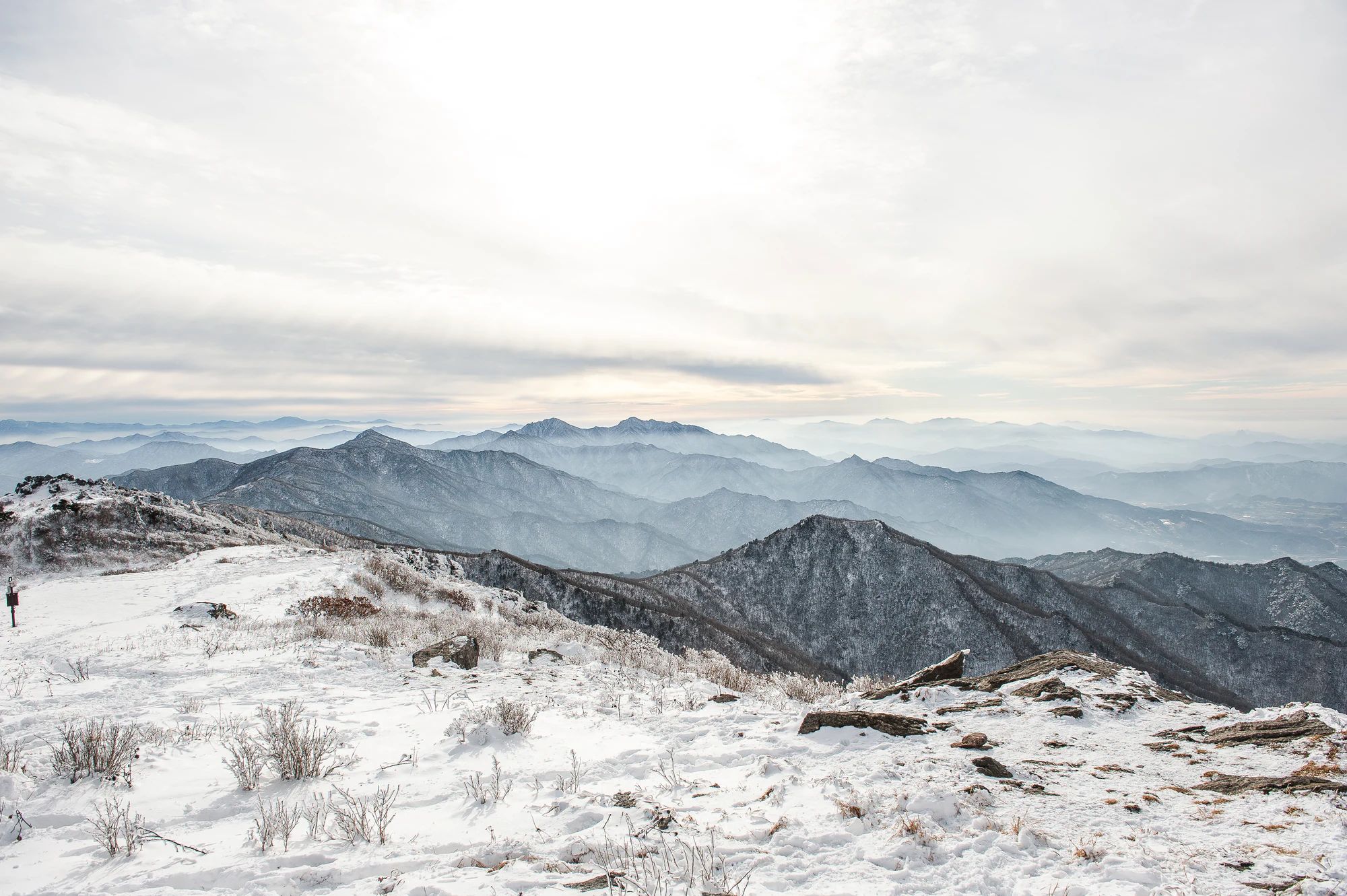
Snow covers an open rocky foreground and low shrubs, with successive dark mountain ridges fading into pale haze beneath a broad cloudy sky.

Snow-covered Deogyusan ridges, photographed on 6 December 2015. The photographer describes a view towards Namdeogyusan and the main ridge; the exact viewpoint is unverified. This historical winter scene does not establish present conditions.

Photo: “덕유산 겨울이야기” by deok rae jo (jodukrae), Flickr. CC BY 2.0; original file unchanged. · Creative Commons 1 · Creative Commons 2

Walks and routes

Gucheondong Eosagil: the forest-and-water choice

Follow the signed old path beside Gucheondong’s stream, where wooded stretches alternate with pools and rock formations such as Inwoldam and Bipadam. The KNPS course from Deogyudae Nature Learning Area to Ansimdae is 3.3 km one way and graded easy. Its summary gives 1 hour 30 minutes; the detailed introduction says 1 hour 40 minutes, so allow at least that much outward time before stops. You can turn earlier. The longer restored path reaches Baengnyeonsa at roughly 5 km; it is not the same measured section. For a relaxed visit, decide at the start whether your goal is an early pool, Ansimdae or the temple. The broader valley route offers an alternative return where signs and current access permit.


Gucheondong Eosagil: the forest-and-water choice

Seolcheonbong to Hyangjeokbong: the short summit approach

Ride the resort’s sightseeing gondola to Seolcheonbong, then follow the signed 0.6 km path to Hyangjeokbong. KNPS gives 20 minutes one way and a moderate course grade. Wooden decking and steps lead through high-elevation vegetation, including yew groves, before the summit view opens out. The distance is short, but exposed weather, ice and crowded steps can make it slow. Wear walking or hiking footwear, carry a warm layer and allow time to return to the upper station well before the last descent. Add ticketing, queues, the ride, photographs and both walking directions when planning the visit.

Seolcheonbong to Hyangjeokbong: the short summit approach

Gucheondong to Hyangjeokbong: the long way up

KNPS publishes 8.5 km and 3 hours one way from Gucheondong Trail Support Center via Inwoldam and Baengnyeonsa. The first 6 km to the temple are relatively gentle; beyond it, the final 2.5 km become a steep stair-and-mountain-path ascent. That change is the important decision point: stop at Baengnyeonsa if the group came for a valley walk. An out-and-back summit day is about 17 km using the published section length, before extra approach walking. Start early and budget a full day with a generous descent margin. The forest approach makes the arrival at the high summit especially satisfying when weather allows.

Gucheondong to Hyangjeokbong: the long way up

Anseong to Dongyeopnyeong: a western ridge outing

From Anseong Trail Support Center, take the signed route through Chilyeon junction towards Dongyeopnyeong. The general KNPS course is 4.5 km and 2 hours one way, graded moderate; the separate seasonal reservation notice measures its managed section as 4.4 km. Keep those measurements distinct. The upper path narrows and climbs to a ridge junction with views towards the park’s two sides. Return the same way unless you have planned a longer ridge traverse and its exit. The Chilyeon Falls spur is closed in the current control notice. Its appearance as a highlight on an older course description does not reopen it.

Anseong to Dongyeopnyeong: a western ridge outing

Yeonggak to Namdeogyusan: for confident mountain walkers

The southern route climbs 3.6 km from Yeonggak Trail Support Center to the 1,507 m Namdeogyusan summit; KNPS gives 2 hours 30 minutes one way and a difficult grade. The initially easier ground changes into rockier climbing and steep, sustained steps near the crest. Choose it for a mountain day with a comfortable margin for descent, rather than as a quick alternative to the gondola. Exposed stair sections deserve particular caution in wind, ice or poor visibility. This sector brings the park’s southern geography into focus, around the meeting of Geochang, Hamyang and Jangsu.

Yeonggak to Namdeogyusan: for confident mountain walkers

Seochang to Anguksa: Jeoksangsan’s cultural slopes

On the Jeoksangsan side, the 3.8 km Seochang course takes about 2 hours one way in KNPS guidance and is graded moderate. Follow the signed ascent past Jangdobawi and the fortress’s western-gate area to the junction for Anguksa. Woodland, stonework and the temple make this an appealing separate outing, especially in autumn. Despite the gentler course description, it is a climb with steps, and KNPS warns of cliffs and rockfall. Stay within the signed trail. Do not continue from Anguksa to Anryeomdae: that section remains in the current closure notice. Allow the return walk as well as temple time.

Seochang to Anguksa: Jeoksangsan’s cultural slopes

An unhurried first visit

Choose Gucheondong, check controls at the trail entrance and walk into Eosagil. Give yourself an early turnaround option at the first scenic pools. Continue towards Ansimdae only while the return still feels comfortable. With a full half-day and a group happy to walk farther, make Baengnyeonsa the goal; keep the summit for another day.

A summit-focused day

Confirm both gondola operation and the summit trail, arrive with your booking if required, and take the short Seolcheonbong approach. Spend time at the top only within the weather and last-descent margin. If the lift or mountain is closed, switch plans before travelling up, rather than substituting an unfamiliar long ascent.

Things to try

Two separate bookings to understand

The resort currently requires advance gondola reservations on weekends and public holidays from October through February; March–September uses on-site ticketing, and ordinary weekdays also use on-site ticketing. The displayed standard adult return fare is KRW 25,000, checked on 18 October 2026. Hours vary by season and weekday, and wind can halt service. Check the operator’s gondola page and its daily status before committing. Separately, the dated 2026 KNPS trail-reservation programme for Seolcheonbong–Hyangjeokbong and Anseong–Dongyeopnyeong ran from 19 May to 22 June, 10:00–15:00. Those past dates do not establish a year-round requirement or next year’s schedule.

Photograph the mountain without leaving the trail

Use signed stopping places for the layered ridge views, and keep steps and narrow boardwalks clear while taking photographs. In Gucheondong, work from the walking path rather than stepping onto wet stream rocks. A dramatic winter photograph is a reason to prepare carefully, not a promise of snow, clear visibility or safe access on your day.

If the forecast spoils the mountain day

If there is no warning or closure and conditions remain suitable, a brief lower-valley walk with an early turnaround may be enough. During heavy rain, thunderstorms or unsafe wind, choose an indoor day elsewhere and return in better weather. A forest canopy or temple stop does not make a closed or hazardous route safe.

Wildlife and habitats

Korean fir in a subalpine landscape

KNPS identifies Korean fir, Abies koreana, as one of Deogyusan’s flagship species. Its needles have pale undersides and slightly notched tips, though identification among mountain conifers takes care. Look from the marked path and leave cones and branches where they are. The linked nature reference covers the broader fir genus.

Yew groves near the summit approach

The municipality records Taxus cuspidata around Hyangjeokbong, and KNPS describes yews along the Seolcheonbong approach. Their dense, dark-green needles give the short summit walk interest beyond the viewpoint. View them without entering protected root areas. The linked nature reference covers the broader yew genus.

Gucheondong’s cold-water resident

The Kumgang fat minnow is the park’s other flagship species. KNPS places it in the cold, oxygen-rich water of Gucheondong. Enjoy the habitat from the bank; do not enter the stream, move stones or catch fish to improve a sighting. A small fish seen from a bridge is not enough for a confident identification.

Stories and discoveries

Two river systems begin in this mountain landscape

KNPS describes Deogyusan as a source area for the Geum River to the north and the Nakdong River to the east. The streams beside the lower walks are part of that much larger watershed story.

A mountain with an archive story

Jeoksangsan once housed a royal-annals archive. Its fortress and Anguksa give the Seochang walk a different emphasis from the high-ridge routes, so leave time to read the interpretation rather than treating the temple as a turnaround marker alone.

When to visit

Spring: fresh forest, then high-country flowers

The valley and summit develop at different speeds. Choose the route for its current conditions, and check fire-season controls before planning a ridge day. Flowers are a seasonal possibility, not a fixed-date attraction.

Summer: shade with a weather escape plan

Gucheondong’s canopy makes a lower walk appealing, but heavy rain changes the decision. Keep away from swollen streams and slippery rocks, and abandon the walk when warnings or closures require it.

Autumn: valley colour or Jeoksangsan history

Pair woodland colour with Anguksa and the fortress route, or choose a clear summit day. Weekend gondola booking rules begin in October; high-ridge hiking still needs a separate check for wind and trail controls.

Winter: short distances still need mountain equipment

Snow and rime can transform the ridge, while icy steps, strong wind and reduced daylight make progress slower. Bring suitable footwear, traction and insulation, and be ready to turn back. Do not extend a gondola visit onto a long ridge simply because the snow looks inviting.

Getting there and practical advice

Use the lower facilities before climbing

The Gucheondong route guide identifies rest areas and toilets along the valley approach, including near Wolhatan, Ansimdae and Baengnyeonsa. Use the available facilities before the steep climb and carry your own water and food; do not base the day on an unconfirmed shop or water source. Deogyudae camping and Satgatjae shelter stays require their own planning and current booking checks. A shelter on the map is not an available bed.

Navigate to an entrance, not simply “Deogyusan”

Use Gucheondong Trail Support Center for the valley, Muju Deogyusan Resort for the gondola, Anseong Trail Support Center for Dongyeopnyeong, Yeonggak Trail Support Center for Namdeogyusan, and Seochang Park Guard Post for Jeoksangsan. These starting points are not interchangeable. The resort’s transport guide describes arrival through Muju terminal with a taxi or local connection; check the actual onward service and last return before leaving town. A one-way hike across the ridge needs a separately arranged exit. Current bus times, taxi fares and parking charges are not confirmed here.

Make the lower route fit the person

Ask the park office about the exact valley section you plan to use, including surface, slope, steps, toilet access and how far it is from the drop-off. The wider approach towards Baengnyeonsa and the narrower Eosagil should not be assumed to offer identical access. For the gondola, ask the operator about your mobility device and boarding arrangements separately from the mountain walk.

Entry cutoffs are route-specific

KNPS currently lists Gucheondong-to-summit entry as 04:00–15:00 in April–October and 05:00–14:00 in November–March; the lower walk towards Baengnyeonsa has a later cutoff. Yeonggak’s Namdeogyusan entry closes at 14:00 in the warmer season and 13:00 in the colder season. These are entry limits, not suggested starting times. Start well before the cutoff for a long return hike, and recheck the official entry-time table alongside current controls.

Sources and useful links

Wildlife you might spot

2

Each card links to a full Explore page with photos, traits, and fun facts.

Snap map for this place

Start with the big picture, then zoom in to explore individual wildlife observations around this place.

Loading map…

Good to know before you go

Pick the trailhead before booking transport: Gucheondong, the resort, Anseong, Yeonggak and Seochang are different arrival points.

Keep enough time and energy to retrace your route; a published outward time does not include the descent.

Carry water, food, a warm layer and weather protection. Bring winter traction when conditions require it.

Check the gondola’s final downhill departure before leaving its upper station; never rely on it as an unconfirmed escape route.

Stay on signed paths and keep out of closed waterfall spurs and fenced vegetation. Leave flowers, cones and stream wildlife undisturbed.

For a park emergency call 119 and give the nearest location-marker number. Save your intended route offline before setting off.

Frequently asked questions

Do not treat the two as interchangeable. The resort operates the gondola; KNPS manages the trails. A seasonal trail-reservation scheme can apply independently of your lift booking. Check both systems for the date you intend to visit.
Both figures describe published versions of the walk with different endpoints. The KNPS 3.3 km course finishes at Ansimdae. The restored Eosagil continuing to Baengnyeonsa is described as approximately 5 km. Neither figure includes the walk back or necessarily the approach from your parking space.
That is a different, much longer day from returning to the gondola. The descent via Baengnyeonsa ends at another trailhead, with substantial walking and a transport problem to solve. Plan it explicitly with current trail access and a confirmed onward journey; do not improvise it because the lift queue is long.
No. A shorter Gucheondong walk gives you forest, water and several named scenic places without committing to the high mountain. Choose your turnaround from the time, conditions and energy you actually have.

Recent snaps at this place

Recent snaps will appear here as new observations are added.

View all ›

Take the discovery with you

Exploring Deogyusan National Park?

Identify the wildlife you spot, learn as you go, and keep a collection of the adventure.

  1. 1Spot it
  2. 2Snap it
  3. 3Keep the discovery