
Snappit logo
Snappit
Get App
Generic illustration, not a photograph of this venueIllustration
ParkKR

Hallasan National Park

The important choice comes before you put on your boots: do you want to look into Baengnokdam, or enjoy the mountain around it?

About

The important choice comes before you put on your boots: do you want to look into Baengnokdam, or enjoy the mountain around it? Seongpanak and Gwaneumsa are the permitted summit approaches. Eorimok, Yeongsil and Donnaeko reveal the southern mountain landscape without reaching the crater rim. Eoseungsaengak offers a much shorter climb beside the Eorimok visitor centre. Each has its own starting point and turnaround rules, so a generic journey to “Hallasan” is not enough planning. Pick one objective, leave room for the descent, and let mountain weather decide whether it is a suitable day. Take the ultimate field guide with you: use the Snappit app to identify birds, plants, and animals on your trip.

Hallasan became a national park in 1970, following designation of its nature reserve in 1966. In 2007, the mountain became one component of the UNESCO-listed Jeju Volcanic Island and Lava Tubes property. That wider listing also includes Geomunoreum’s lava-tube system and Seongsan Ilchulbong, which are separate destinations. The park is administered by Jeju Special Self-Governing Province’s Hallasan National Park Management Office.

What to do here

For a first high-country visit, choose Yeongsil or Eorimok to Witseoreum and return on the same route. Experienced walkers wanting the crater should reserve a summit route and devote the day to it. For a lighter introduction, pair Eoseungsaengak with the Eorimok exhibits.

Seasonal info

Access checked October 18, 2026: Gwaneumsa’s Samgakbong–Baengnokdam section reopened on September 24 at 05:00 after repairs. October–March cutoffs now apply. A reservation does not override weather controls; check the park’s live information and notices again before setting off.

Accessibility

These are mountain trails with sustained gradients and uneven surfaces. Even the short Eoseungsaengak climb should not be treated as a step-free stroll. For a visit without hiking, ask the Eorimok visitor centre about current step-free access, accessible toilets and parking before travelling.

Don't miss

1

Baengnokdam crater from the permitted eastern summit viewing area

2

Yeongsil’s rock formations and the open country around Witseoreum

3

The changing forest along Seongpanak and Donnaeko

4

Eoseungsaengak’s shorter ascent and clear-day island views

Walks and routes

Seongpanak: the long forest approach

The eastern approach reaches Baengnokdam in 9.6 km, passing Sokbat and Jindallaebat. Official uphill estimates range from 4½ to 5 hours; returning the same way means 19.2 km. Much of the route is wooded, with a harder final climb. Choose it for a steady, substantial mountain day, not because the early forest looks easy. Seongpanak route.

Long mountain walking with a demanding upper section; conserve strength for the descent.
Seongpanak: the long forest approach

Gwaneumsa: valleys and a steeper climb

From the Gwaneumsa campground area, the northern route climbs 8.7 km to the summit, with about 5 hours published for the ascent. Samgakbong shelter is 6 km from the start. Deep valleys and prominent rock formations give this route its character, but the greater height change and steep sections demand energy. A Seongpanak ascent and Gwaneumsa descent is possible only with both routes open and onward transport arranged. Gwaneumsa route.

A strenuous mountain route, including steep climbing and descending; shorter distance does not make it the easier summit choice.

Gwaneumsa: valleys and a steeper climb

Eorimok: forest to Witseoreum

Witseoreum is 4.7 km from Eorimok, with about 2 hours published uphill; continuing to the South Wall Junction makes 6.8 km and about 3 hours one way. The early Sajebi Hill climb is demanding before the terrain becomes gentler around the uplands. Turn at Witseoreum for a shorter outing. Continue toward the crater’s southern wall only when time, conditions and the onward gate permit. Eorimok route.

The easier-looking upper terrain follows a steep forest climb; this is not a level or step-free route.

Eorimok: forest to Witseoreum

Yeongsil: rock walls and open uplands

From the upper Yeongsil rest-area trailhead, Witseoreum is 3.7 km away; the South Wall Junction is 5.8 km from that same start. Yeongsil’s rock formations and Seonjakjiwat’s open uplands make it rewarding without a summit climb. Allow roughly 4–6 hours for a relaxed Witseoreum return, plus any road approach. The lower management-office/bus-stop area adds a 2.5 km approach to the upper trailhead. Yeongsil route.

The ridge above Yeongsil Valley is steep, and exposed ground needs care in wind or fog.

Yeongsil: rock walls and open uplands

Donnaeko: the southern forest ascent

This 7 km route begins above Donnaeko recreation area, passes Pyeonggwe shelter and reaches the South Wall Junction. The detailed park page allows about 3 hours 50 minutes one way. It offers a long ascent through changing forest, from evergreen broadleaved trees to higher-elevation vegetation. There is no spring along the route: bring your full water supply. Treat it as a substantial hiking day. Donnaeko route.

Sustained uphill walking from a lower starting elevation; a return walk is 14 km before any additional connection.

Donnaeko: the southern forest ascent

Eoseungsaengak: a smaller mountain outing

The entrance beside Eorimok visitor centre leads 1.3 km to Eoseungsaengak’s summit. The park publishes about 30 minutes uphill; allow longer for an unhurried return and views. Clear weather can open views across Jeju, while the surviving 1945 Japanese military fortifications add a historical layer. This reaches Eoseungsaengak, not Hallasan’s crater. Eoseungsaengak route.

A shorter climb, still requiring uphill walking. Do not assume wheelchair or stroller suitability.

Eoseungsaengak: a smaller mountain outing

Seokguram: a forest-and-hermitage walk

The 1.5 km route from the National Jeju Cemetery parking area reaches Seokguram hermitage in about 50 minutes one way. Forest, valley scenery and rock faces make this a lower-commitment alternative to the high mountain. The approach from the Cheonwangsa entrance on the 1100 road is additional. Allow around two hours for the trail return and pauses, more if arriving on foot from the road. Seokguram route.

A mountain footpath rather than a paved urban promenade; check conditions and respect worshippers at the hermitage.

Seokguram: a forest-and-hermitage walk

A first visit without a summit booking

On a suitable day, start early on Yeongsil or Eorimok, make Witseoreum your turnaround, and return to the same trailhead. Keep the South Wall extension optional. If your group wants a shorter climb, choose Eoseungsaengak instead and leave time for the visitor centre.

A summit-focused day

Choose a reserved entry early enough for your pace, prepare food and water the evening before, and use the checkpoint as a firm decision point. Returning by the same trail simplifies transport. A cross-mountain finish needs a prearranged connection; do not add a second ambitious activity after the descent.

Things to try

Photograph the landscape without leaving the trail

Yeongsil’s rock formations and the southern crater wall are good reasons to take a camera, but mist may erase the view. Keep photography stops within your time margin. Do not climb beyond barriers or onto cliff edges to improve an angle.

Use the visitor centre when conditions allow

Eorimok visitor centre has exhibits about the volcano, forest zones and mountain life. Confirm opening and safe road access before making it your alternative. Hallasan Museum is a separate facility: a September 22, 2026 notice extends its closure through November 30, with an imprecise November reopening reference. Wait for confirmed reopening before planning a museum visit. In severe weather, stay off mountain roads and postpone the park trip.

Wildlife and habitats

Firs: Korean fir and the high forest

Korean fir, Abies koreana, grows naturally on Hallasan. Provincial researchers study trees around Seongpanak, Witseoreum and Yeongsil, including how well their seeds develop. The forest is a living conservation landscape: admire it from the trail and leave cones, seedlings and dead wood undisturbed.

White-backed Woodpecker

The park lists White-backed Woodpecker among Seongpanak’s wildlife. A quiet forest pause may be more rewarding than hurrying between landmarks, but no sighting is guaranteed. Watch from the path without playing calls, approaching a nest or moving into the trees for a photograph.

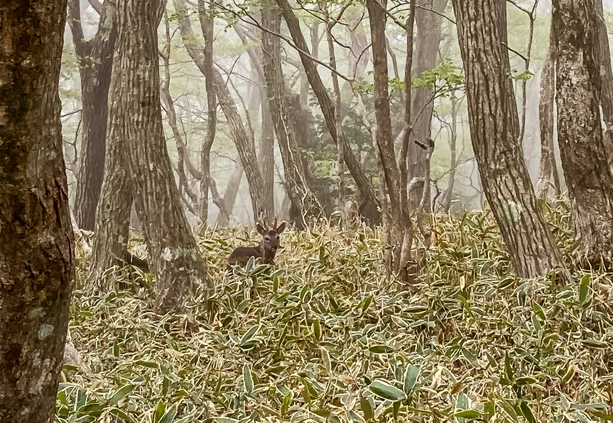
Deer in the woodland

Park descriptions mention deer on Eorimok and Yeongsil. Keep your distance and leave their route clear. The historical photograph here shows a deer, but does not establish its species, a particular trail location or where animals can be found today.

A deer stands among dense low foliage beneath tall trees in a misty forest.

Misty woodland and a deer in a Hallasan photograph dated April 28, 2021 by the photographer. The exact trail and deer species are unverified; this historical scene does not show current access or conditions.

Photo: [“Jeju Hallasan 02”](https://www.flickr.com/photos/192730404%40N08/51168087600) by [A Fun Couple (fritz.guillaume)](https://www.afuncouple.com), [CC BY 2.0](https://creativecommons.org/licenses/by/2.0/). Original file unchanged. · Creative Commons

Stories and discoveries

One mountain, several perspectives

A summit visit looks into the crater from the permitted eastern side; a western or southern walk looks toward its walls from below. Those are different experiences, and the lower viewpoints can make a satisfying destination in their own right.

When to visit

Spring

Flowering shrubs bring colour to the uplands, particularly around the Yeongsil side. Bloom moves with elevation and the year’s weather, so avoid building a fixed-date trip around a promised peak. Cold conditions can persist higher up even when the coast feels mild.

Summer

Forested approaches offer shade, but humidity, rain and sudden poor visibility can make a long hike harder. Carry rain protection and enough water. A forecast for heavy rain or a typhoon is a reason to change the plan, not to switch to an unreserved trail.

Autumn and winter

Autumn woodland colour comes with shortening days and the October switch to earlier limits. Winter adds ice, snow and strong wind; a snow-covered summit is a serious undertaking. Use suitable traction, warm clothing and gloves, and choose a shorter open route or postpone if your equipment or experience is insufficient.

Getting there and practical advice

Shelters and supplies

The official route pages identify shelters at Witseoreum, Jindallaebat, Samgakbong and Pyeonggwe, with toilets at several trailheads and shelter locations. They are useful rest points, not permission for an overnight mountain stay. Buy supplies before travelling: the park warns against relying on shops along the trails.

Parking and camping

Parking is charged separately. The current fee table lists small vehicles at ₩1,000 for the first hour, then ₩500 per additional 20 minutes, capped at ₩13,000 per day. Recheck the tariff for your vehicle and trailhead. Camping and cooking are confined to the designated Gwaneumsa campground; arrange a campsite separately rather than treating a hiking reservation as overnight permission.

Choose the actual trailhead

For Seongpanak, the operator points to buses 281 and 181 on the 5.16 road; for Eorimok and Yeongsil, it points to route 240 on the 1100 road. A bus stop may leave a walk to the trail start, especially at Yeongsil. Check the Jeju bus information service for your date, direction and last return rather than relying on a generic journey time.

Avoid a stranded finish

Seongpanak’s parking is limited and can fill early. If descending to another trailhead, confirm the transfer before climbing. Do not navigate to the park’s Eorimok office when your booking is for Seongpanak or Gwaneumsa; these are different approaches to a large mountain.

A shorter visit still needs a suitable surface

Eoseungsaengak reduces distance, not the need to climb. Visitors who need step-free access should first ask about the Eorimok exhibition building and its approach, including doors, lifts, toilets and any construction. No continuous accessible mountain route has been verified for this guide.

Booking the summit

Reserve through the Hallasan reservation service for the upper Seongpanak or Gwaneumsa section. The dated booking notice opens the following month’s reservations at 09:00 on the first business day of the preceding month. Carry your own QR code and identification. The published windows introduced in December 2025 are 05:00–08:00 and 08:01–11:30; use the slot actually issued for your date. A late slot is not a promise that you can reach the summit.

Cutoffs are checkpoints, not recommended starting times

The park’s September 30, 2026 notice uses October–March and April–September seasons, with entry starting at 05:00. The times below are limits, not suggested starts. You must reach the relevant uphill checkpoint and then meet the descent deadlines. Current seasonal control notice.

October–March limits

Seongpanak entrance and Jindallaebat: 11:30; Gwaneumsa entrance and Samgakbong: 11:30. Leave the summit by 13:30 and Jindallaebat or Samgakbong by 15:30. Eorimok and Yeongsil entry ends at 12:00; Witseoreum’s onward gate toward the South Wall closes at 13:00. Donnaeko entry ends at 10:00. Leave the South Wall Junction by 14:00 and Witseoreum by 15:00.

April–September limits

The summit-route entrance and uphill checkpoint limits become 12:30, summit descent 14:30, and Jindallaebat/Samgakbong descent 16:30. Eorimok and Yeongsil entry ends at 15:00, Witseoreum’s onward South Wall gate at 14:00, and Donnaeko entry at 11:00. Leave the South Wall Junction by 15:00 and Witseoreum by 17:00. Check your reservation separately; seasonal controls do not change its issued entry window.

Sources and useful links

Wildlife you might spot

2

Each card links to a full Explore page with photos, traits, and fun facts.

We are still adding species preview cards for this place.

Snap map for this place

Start with the big picture, then zoom in to explore individual wildlife observations around this place.

Loading map…

Good to know before you go

Carry enough water and food for the entire walk; do not rely on a trail shop or spring.

Pack rain protection, an insulating layer, a charged phone and a headlamp. In snow or ice, use suitable winter equipment and skills.

Keep to designated trails and respect barriers, even when another route appears to lead toward the summit.

Take all litter back down. Leave plants, cones, rocks and insects where they are.

Never feed or approach wildlife. Let an animal move away without following it into the vegetation.

If an emergency occurs, call 119 and give the number on the nearest trail location sign.

If you cannot use a summit booking, cancel it before its permitted entry period ends.

Frequently asked questions

No. The permitted summit approaches are Seongpanak and Gwaneumsa. Witseoreum and the South Wall Junction are separate destinations; closed continuations do not become available because you have a summit reservation.
No. The reservation system covers the upper summit sections beyond Jindallaebat on Seongpanak and Samgakbong on Gwaneumsa. The other five listed trails do not require that summit booking, but access times and weather controls still apply.
Not necessarily. You must reach the mountain checkpoint before its cutoff, then leave the summit by its descent deadline. Choose your start from the full walking time and your pace, not simply the latest time the booking system offers.
No. The park lists the Baengnokdam circuit outside the eastern summit area as restricted. Stay within the permitted viewing area and return by an open designated route.

Recent snaps at this place

Recent snaps will appear here as new observations are added.

View all ›

Take the discovery with you

Exploring Hallasan National Park?

Identify the wildlife you spot, learn as you go, and keep a collection of the adventure.

  1. 1Spot it
  2. 2Snap it
  3. 3Keep the discovery
