Snappit logo
Snappit
Get App
Generic illustration, not a photograph of this venueIllustration
ParkChubu / Kanto, Japan

Joshin'etsukogen National Park

Joshin'etsukogen is far too big to treat as one sightseeing stop.

About

Joshin'etsukogen is far too big to treat as one sightseeing stop. The national park spreads across Nagano, Gunma and Niigata, bringing together volcanic highlands, forested mountains, hot-spring country and the steep scenery of the Tanigawa range. For a relaxed first encounter, head to Hasuike in Shiga Kogen, on the Nagano side. You can learn a little about the landscape, walk beside a pond and still leave room in the day for unhurried looking.

Start at Shiga Kogen Visitor Center, in Sogo Kaikan 98 opposite the Yamanoeki bus terminal. If your map calls it the Shiga Kogen Nature Protection Center, you have the right place: it reopened under its new name on 27 April 2026. The updated displays connect the area's landforms, wildlife and human history. A digital landscape model and seasonal films help put the ponds and mountains into perspective before you go outside.

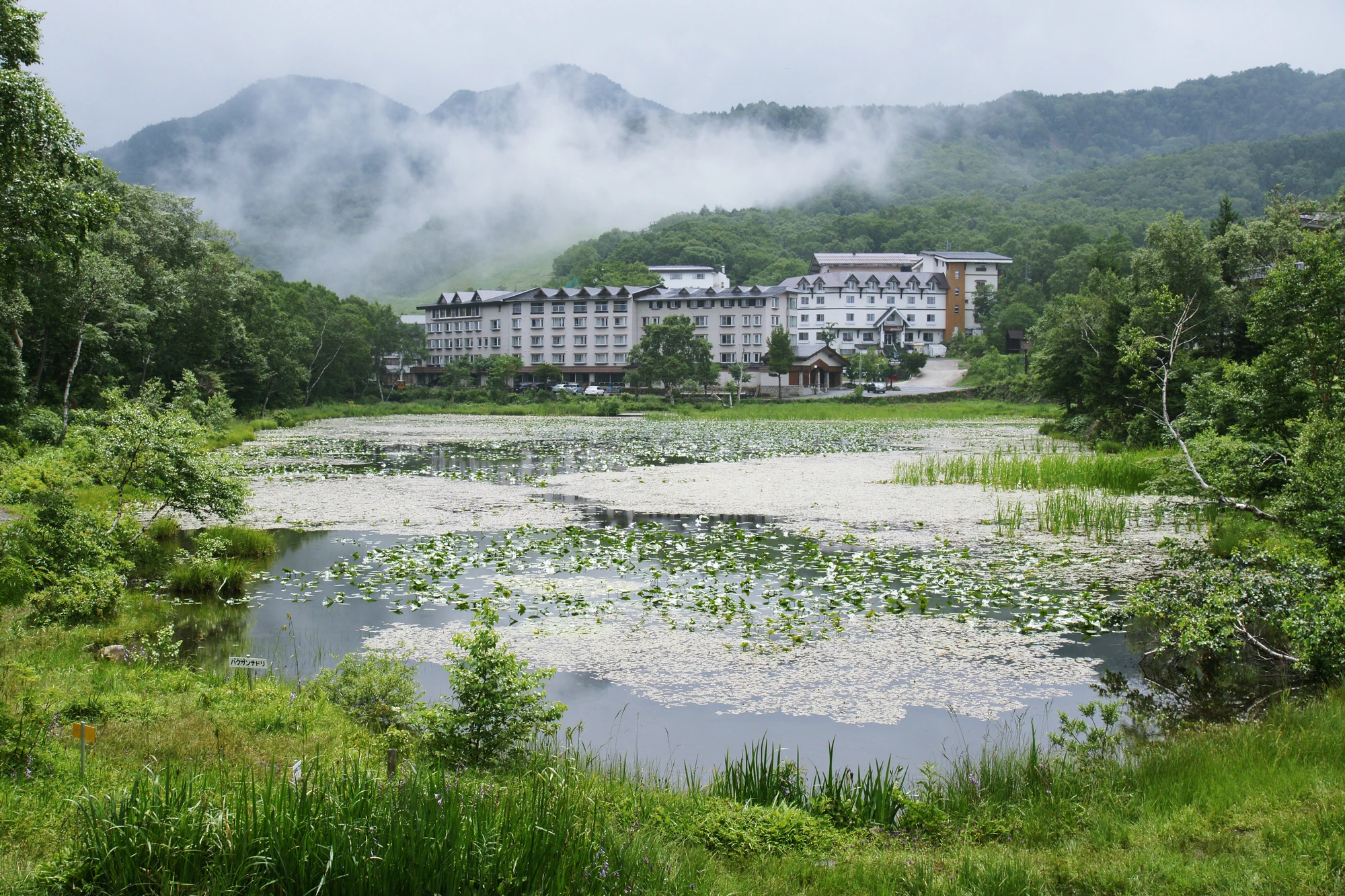
Hasuike is the easiest place to put that introduction to use. Its gravel waterside circuit is short enough to enjoy without committing to a mountain hike. Pause by the interpretation boards, watch the changing reflections and look closely at the plants along the water. Bogbean is one of the early-season plants to look for; later, the pond supports water-lily-like flowers. Autumn turns the same small scene into a study of colored leaves and their reflections. A still moment here can be more rewarding than rushing between viewpoints.

If you want a fuller outing, the Nature Discovery Trail links Kidoike, Tanohara wetland, small forest ponds and Hasuike. It gives you a satisfying change of surroundings: open wetland, shaded woodland and water held among volcanic terrain. Take a bus to Kidoike and walk back toward the visitor-center area, or join a guided walk. This is a moderate, uneven trail with some rocky sections, rather than a longer version of the easy pond stroll.

The highlands reward a flexible plan. Snow can outlast spring in the towns below, summer rain can make footing slippery, and autumn weather can turn cold quickly. Use the visitor center to choose what suits the day. With children, limited time or uncertain weather, the exhibits and Hasuike are a complete outing in their own right. Explore the grounds like a pro—download the Snappit app to instantly identify animals and plants.

Joshin'etsukogen National Park was designated on 7 September 1949. Shiga Kogen's ponds and wetlands owe much of their setting to earlier volcanic activity, which left an irregular lava landscape where water could collect. The local visitor facility began as a nature classroom in July 1970, became the Nature Protection Center in 1997, and reopened as Shiga Kogen Visitor Center in April 2026.


What to do here

Visit the renewed center, then take a slow circuit of Hasuike while the path is snow-free and open. Look for pond-edge plants, compare the reflections from different parts of the shore and read the interpretation boards. For a more substantial walk, choose the 4.1 km Nature Discovery Trail from Kidoike toward Hasuike, allowing time for Tanohara wetland and the forest ponds. A guide is a good choice for noticing small plants and understanding the volcanic landscape.

Seasonal info

Spring walking depends on snowmelt. In early summer, look for bogbean near Hasuike and cotton-grass seedheads at Tanohara wetland. Autumn color progresses down from the higher ground, with the Hasuike area changing later than the highest slopes. Once snow and ice arrive, switch to a winter plan: guided snowshoeing and skiing have their own routes, equipment and operating dates. A summer footpath or lift listing does not establish winter access.

Accessibility

The visitor center has a ramped entrance, a multipurpose toilet and one free loan wheelchair; call ahead for the wheelchair and the best parking approach. Hasuike has a gravel path, so ask about the current surface before using a wheelchair or stroller. The Nature Discovery Trail includes uneven and rocky ground and should not be treated as step-free. Nearby Biwaike has a paved lakeside path, but its approach from Sun Valley includes a steep gradient; discuss a suitable access point before traveling.

Don't miss

1

The visitor center’s digital landscape model and seasonal films

2

A short Hasuike walk with pond plants and autumn reflections

3

Tanohara wetland and shaded forest on the Nature Discovery Trail

4

A guided nature walk that makes small seasonal details easier to notice

A pond covered in floating leaves fills the foreground, with green shoreline vegetation, pale buildings and misty wooded slopes beyond.

Hasuike in summer, with floating leaves, shoreline buildings and mist over Shiga Kogen. Photographed on 24 July 2009.

Hasuike03bs4272.jpg — 663highland, CC BY 2.5 (https://creativecommons.org/licenses/by/2.5/). Source: https://commons.wikimedia.org/wiki/File:Hasuike03bs4272.jpg. Resized and recompressed as WebP; no crop or retouching. · Creative Commons

Walks and routes

Hasuike pond circuit

A compact circuit beside Hasuike with interpretation boards and changing reflections. Begin only after checking that the path is open and clear enough for your group.

Gravel surface; do not assume a smooth, step-free circuit. Ask the center about the current surface and a manageable section.

Hasuike pond circuit

Nature Discovery Trail: Kidoike to Hasuike

Use a suitable bus from Yamanoeki to Kidoike, then walk the signed trail via Tanohara wetland, Misumaike and Nagaike toward Hasuike and Yamanoeki. Bring the current route map and follow any signed changes. The 4.1 km figure is one-way.

Officially moderate. Uneven ground and some rocky sections; unsuitable as a wheelchair or stroller route. The published 160 m elevation difference is not total ascent.

Nature Discovery Trail: Kidoike to Hasuike

Start at the visitor center for the model, displays and current outdoor advice.

Walk to Hasuike and take the pond circuit slowly if conditions suit your group.

Leave time for a rest before your bus or onward drive. Extend the visit only if the weather, footing and return time allow.

Check the Nature Discovery Trail and Misumaike fallen-tree situation at the center; decide against the full walk if access is doubtful.

Take a suitable bus to Kidoike and walk the signed Nature Discovery Trail back toward Hasuike.

Pause at Tanohara wetland, then enjoy the change to shaded forest and small ponds. Keep enough time in hand for your bus home.

Things to try

Read the landscape indoors

Use the digital model to locate the ponds and mountains, then choose one feature to recognize outside. The seasonal films also make a useful introduction when low cloud hides the wider view.

Slow down at the pond edge

Pick a spot on the path and look for three things: a plant above the water, a reflection and a small movement on the surface. Take photographs from the path rather than moving into soft ground for a closer angle.

Let a guide choose the small discoveries

Ask about a short nature-observation walk if a full trail feels too much. The center offers seasonal mini hikes around local ponds and longer guided outings; routes, availability and fees depend on the program.

Stay with the exhibits

Spend more time at the model and films, and ask whether a paid indoor craft activity is running. If rain is heavy or thunder is possible, leave the outdoor route for another day.

Wildlife and habitats

Bogbean

Look for leaves divided into three leaflets and small, fringed white flowers above the water. Early summer is a useful window; stay on the pond path.

Threeleaf goldthread

A low-growing plant worth noticing beside the trail rather than only looking up at the trees. Its small pale flowers are easy to overlook; the local flowering calendar gives June to July.

False lily-of-the-valley

Look for broad, heart-shaped leaves and small creamy-white flower clusters. Notice it without picking leaves or berries.

Asian black bear

Learn about this forest resident in the center. Outdoors, follow the day’s bear advice, keep food sealed and give any animal ample space; do not go looking for it.

Stories and discoveries

Water in a volcanic landscape

Shiga Kogen’s uneven volcanic terrain created depressions where ponds and wetlands could develop. The quiet water and the rugged landforms are parts of the same story.

Cotton without a cotton plant

The fluffy white cotton-grass tufts at Tanohara appear after its small flowers. Look for them in early summer, with timing shaped by the season.

When to visit

early-summer

Look for fresh foliage and pond-edge flowers. Tanohara cotton-grass can be a good reason to choose the longer trail once it is snow-free.

autumn

Use the day’s leaf-color reports to choose between the lower ponds and higher viewpoints; dress for a cold return journey.

winter

Keep the visitor center in the plan, but replace summer hiking with a properly equipped winter activity. Confirm road access, transport and toilet availability separately.

Getting there and practical advice

Shiga Kogen Visitor Center

Free exhibits in Sogo Kaikan 98 at Hasuike. Published opening: daily, 09:00–16:00. Guided outings and craft activities have separate arrangements and charges.

Shiga Kogen Visitor Center

Toilets before the walk

The visitor-center toilet is available during opening hours. Check the seasonal status of Kidoike and Nagaike toilets before choosing the longer route.

Toilets before the walk

Aim for Shiga Kogen Yamanoeki, the bus terminal opposite the center. Direct express buses from Nagano take about 70 minutes; the alternative is train to Yudanaka and a local bus, about 30 minutes for the bus leg. Add connection and waiting time. Check whether your service needs a cashless payment method or a ticket purchased before boarding.

www.shigakogen.gr.jp

Approach Hasuike from the Nagano side via Route 292 and check road conditions. Free parking is available at Sogo Kaikan 98; ask for the ramp-side approach if you need step-free entry. The onward Shiga–Kusatsu highland road normally closes in winter, with dates and weather restrictions checked separately.

visitor-center.shigakogen.gr.jp

Visitor center

Use the ramped entrance on the Yamanoeki side. A multipurpose toilet and a single loan wheelchair are provided; contact the center before relying on the wheelchair.

Biwaike alternative

The lakeside section is paved, but the Sun Valley approach is steep. Ask for advice on a suitable arrival point and assistance before substituting it for Hasuike.

Sources and useful links

Wildlife you might spot

4

Each card links to a full Explore page with photos, traits, and fun facts.

We are still adding species preview cards for this place.

Snap map for this place

Start with the big picture, then zoom in to explore individual wildlife observations around this place.

Loading map…

Good to know before you go

Ask at the center about the day’s path conditions and bear reports. A fallen-tree caution near Misumaike was listed on the Nature Discovery Trail when checked on 16 October 2026.

Save the return bus time before setting out. Seasonal schedules and individual route operating days differ; some express buses are cashless-only.

Carry rainwear, a warm layer, drinking water and food. Wear shoes with grip, even for a modest highland outing.

Make your presence known while walking, preferably with companions, and carry a bear bell as locally advised. Keep food and rubbish sealed and take everything away.

If you see a bear, keep it in view and back away slowly. Do not run, shout, approach it for a photograph or throw things.

Stay on the path and boardwalk. Leave plants, insects and mushrooms where they are, and never feed wildlife.

Use the toilet before a longer walk. Several outdoor toilets close for winter; the visitor-center toilet follows building hours.

Treat a drive onward toward Kusatsu-Shirane as a separate plan. Check volcanic restrictions, road notices and winter closures before adding it to your day.

Frequently asked questions

Yes. It reopened as Shiga Kogen Visitor Center on 27 April 2026. Look for it in Sogo Kaikan 98 at Hasuike, opposite Shiga Kogen Yamanoeki. The published hours are 09:00–16:00 daily, with free admission; check for exceptional notices before traveling.
Yes. Combine the exhibits with the short Hasuike pond circuit, and leave time to sit and look. Check the path first if there is snow, ice, heavy rain or a local closure.
Use the express bus from Nagano Station’s east side to Shiga Kogen Yamanoeki, typically around 70 minutes. Another option is the Nagano Electric Railway to Yudanaka followed by a local bus. Check the timetable for your date and the return journey before departure.
The 4.1 km itinerary described here is a one-way walk between Kidoike and Hasuike. Take a suitable bus to Kidoike first, then walk back, or arrange your return transport before starting. Do not allow only 4.1 km for an out-and-back walk.
Wild animals live in Shiga Kogen, but sightings are unpredictable. Bears are a reason to follow local precautions, not an attraction to seek out. The managed monkey-watching visit at Jigokudani is a separate excursion, not part of this Hasuike walk.
Spend longer with the center’s exhibits and ask about an indoor craft activity, which has a separate fee. Skip the outdoor walk in heavy rain, thunder, strong wind or unsafe footing; light rain is only manageable with appropriate clothing and suitable conditions.

Recent snaps at this place

Recent snaps will appear here as new observations are added.

View all ›

Take the discovery with you

Exploring Joshin'etsukogen National Park?

Identify the wildlife you spot, learn as you go, and keep a collection of the adventure.

  1. 1Spot it
  2. 2Snap it
  3. 3Keep the discovery