
Snappit logo
Snappit
Get App
Generic illustration, not a photograph of this venueIllustration
ParkKyushu, Japan

Kirishima-Kinkowan National Park

Kirishima-Kinkowan is a national park of separate volcanic and coastal landscapes across Miyazaki and Kagoshima prefectures.

About

Kirishima-Kinkowan is a national park of separate volcanic and coastal landscapes across Miyazaki and Kagoshima prefectures. For a manageable first visit, concentrate on Sakurajima’s western shore: start at Sakurajima Visitor Center, then explore the nearby Yogan Nagisa coastal path. The Kirishima mountains and their crater lakes belong to another part of the park and need their own travel plan.

Inside the center, eruption models and volcanic-rock displays help make sense of the mountain outside. The vegetation exhibit is especially useful before a walk: it explains how life returns to lava after an eruption. Give yourself time to ask about the day’s ash, weather and path conditions before deciding how far to go.

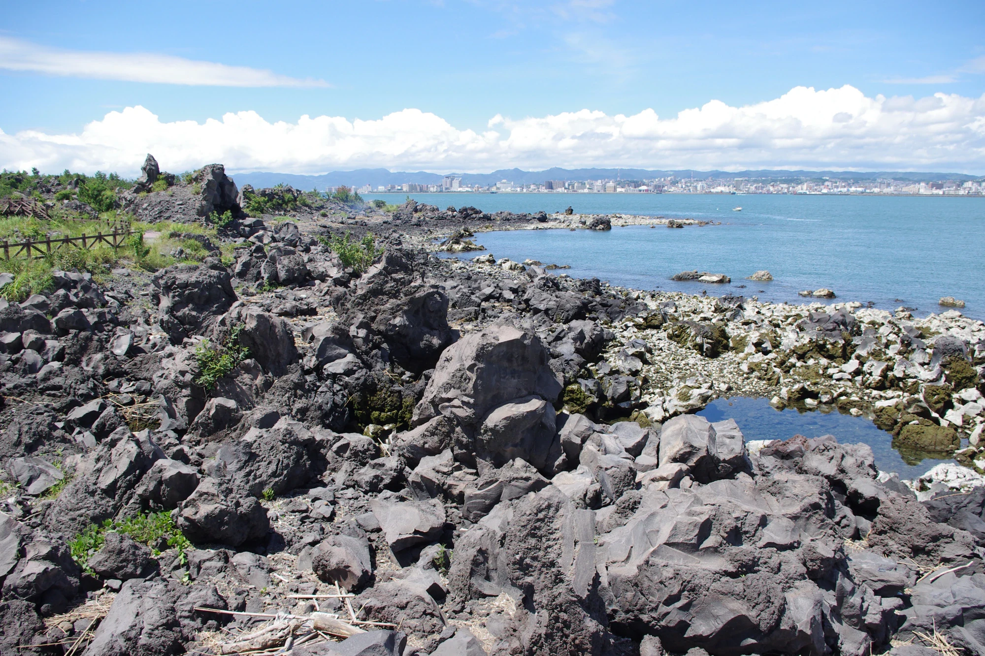
The Yogan Nagisa Trail crosses lava laid down in the 1914 Taisho eruption. Dark rock, patches of low growth and Japanese black pine woodland sit beside Kinko Bay, with Kagoshima’s cityscape across the water. Look closely at the spaces between rocks: the interest is in how much has returned to ground that once had very little growing on it.

You do not need to reach the far end to enjoy this coast. A short out-and-back leaves time for the museum and, when it is operating, the nearby footbath. For a longer walk, the full trail leads to Karasujima Observatory, named for a former island buried by the same eruption. Treat Sakurajima as an active volcano throughout the visit, and let current local advice shape the day. Wondering what that bird or insect is? Find out on your visit using the Snappit nature app.

The national park’s origins date to 1934. On Sakurajima, the defining local event is the 1914 Taisho eruption: its lava joined the former island to the Osumi Peninsula and buried nearby Karasujima. The western coastal trail lets you see the resulting lava landscape and the vegetation that has developed since.

What to do here

Pair the visitor center with a short walk from Yogan Nagisa Park along the signed coastal trail. Compare exposed lava with the plants growing around it, pause for bay views, and turn back while everyone still has energy for the return.

Seasonal info

June and early July can be very wet; midsummer brings heat and humidity. Typhoons can disrupt travel from summer into autumn. Winter calls for a windproof layer by the bay. Ashfall can affect plans in any season.

Accessibility

The visitor center has a main-entrance ramp and multipurpose restroom. The prefectural access listing for the coastal trail records both ramps and steps, so ask staff which section suits your wheelchair or stroller before setting off.

Don't miss

1

Use the volcano models to connect the eruption story with the landscape outside.

2

Walk beside the dark 1914 lava and watch for plants establishing themselves between rocks.

3

Look across Kinko Bay toward Kagoshima from the coastal path.

4

Finish at the long outdoor footbath when it is open, with a towel of your own.

Dark, jagged coastal lava rocks and patches of greenery beside blue water, with a city across the bay.

Rough lava beside Sakurajima’s Nagisa Lava Trail, with Kagoshima across the bay. Photographed on 21 July 2010.

20100721 Sakurajima Nagisa Lava Trail 3963.jpg — Jakub Hałun, CC BY-SA 4.0 (https://creativecommons.org/licenses/by-sa/4.0/). Source: https://commons.wikimedia.org/wiki/File:20100721_Sakurajima_Nagisa_Lava_Trail_3963.jpg. Resized and recompressed as WebP; no crop or retouching. · Creative Commons

Walks and routes

A short look along the lava coast

After asking at the center, start from nearby Yogan Nagisa Park and follow the signed path toward Karasujima. Walk outward for about 15–20 minutes at your own pace, then return the same way. Allow 45–60 minutes altogether, leaving room to stop and look at the lava and bay. Turn around sooner if anyone is tired or the conditions change.

Ask which approach and section avoid steps. Choose the turnaround to suit your group rather than committing to an unfamiliar return.

A short look along the lava coast

Continue to Karasujima if you want a longer walk

The full trail is about 3 km each way between the park and Karasujima Observatory. Allow 60–90 minutes outward with stops and enough time for the return: retracing it means roughly 6 km of trail walking. Add the museum and ferry approach separately. At Karasujima, the story of the island buried by lava gives the viewpoint a different meaning.

Do not assume the full trail or the observatory approach is step-free; confirm the details before choosing this longer option.

Continue to Karasujima if you want a longer walk

Spend around 30–40 minutes with the exhibits and ask staff about today’s coastal conditions.

Use 45–60 minutes for the short out-and-back, including observation stops.

Leave about 15–20 minutes for the footbath or a seated break before returning toward the ferry. Add a little spare time so a slower walk does not become a rush.

Things to try

Match the model to the mountain

In the museum, choose one eruption shown in the models. Before leaving, ask which part of its story you can see on today’s permitted walk. This works well for children who prefer a question to a long list of dates.

Make a three-texture photo set

From the paved path, take one picture of rock, one of low vegetation and one of a tree growing on lava. Compare the shapes and colours. Keep your feet on the path, even if the best-looking rock is just beyond it.

Watch the crossing from the coast

Pause where the path gives you a bay view and watch the ferries move between Sakurajima and Kagoshima. It is a simple way to link the landscape with the everyday journeys that still happen around this active volcano.

Make the museum the main visit

Stay with the eruption models, rock samples and vegetation exhibits if rain or cloud spoils the view. The coast is an optional extra. In severe weather or worsening volcanic conditions, follow local instructions and reconsider the journey itself.

Wildlife and habitats

Japanese black pine

Japanese black pine grows on the lava along this western-coast walk, with groves also recorded around Karasujima. Look at the contrast between trees, low plants and exposed rock rather than expecting every stretch to look the same.

Stories and discoveries

The island that disappeared under lava

Karasujima used to sit offshore. The 1914 lava flow buried it, and the observatory now stands in that transformed landscape. It is a striking example of how an eruption can redraw a coastline.

A forest is part of the eruption story

The lava is only half the scene. Mosses, grasses and trees return as conditions change, and the center’s vegetation displays help you read that recovery outside. Different-looking patches are a reason to slow down and look, rather than a race to the next viewpoint.

When to visit

Spring and autumn

Choose these seasons for a longer walk when the forecast is settled. Keep a light rain layer handy and let the actual temperature, rather than the calendar, decide how far you go.

Rainy season and summer

Keep the coast optional during June and early July’s rain. In hot, humid weather, put more of the visit indoors, carry water and take breaks. If a typhoon threatens, check travel notices and postpone the outdoor plan.

Winter by the bay

Bring a windproof outer layer and leave enough daylight for the return. A shorter coast walk followed by the museum is a useful option on a cold day, provided you check the path conditions before going out.

Getting there and practical advice

Sakurajima Visitor Center

The regular schedule is 9 am–5 pm, year-round, with free admission. There is a shop, a multipurpose restroom, a nursing room and a diaper-changing station. Check notices before travelling, because severe weather can close the building.

Yogan Nagisa Park footbath

The outdoor footbath is about 100 m long, with bay and mountain views. Regular hours are 9 am to sunset. Bring a towel and check that it is operating before making it the promised finale to your day.

Ferry and a short walk

The regular Kagoshima–Sakurajima ferry crossing takes about 15 minutes; weather and sea conditions can make it nearer 20. Add time for boarding, disembarking and queues, then allow about 10 minutes on foot from Sakurajima Port to the center.

Check the return sailing

The ferry ended 24-hour operation on 1 October 2025. Use the current timetable and service notices for your date, especially around unusual weather or special-event days. A published timetable does not guarantee a sailing will run.

Plan the building, path and ferry separately

Start with the center’s ramped main entrance and ask staff about the outdoor surface and any steps on your chosen stretch. The ferry operator publishes a dated barrier-free-vessel timetable; check the latest version and confirm any boarding assistance you need. Do not rely on every departure using the same type of ship.

Before you head outside

On 16 October 2026, JMA’s Sakurajima bulletin kept Alert Level 3 in force. Kagoshima City prohibits entry within 2 km of either the Minamidake summit crater or Showa crater. Ash and small falling volcanic stones can travel farther downwind; strong volcanic air blasts can break windows, and heavy rain after ashfall can bring debris flows. Check the latest Sakurajima bulletin, local access notices and ash forecast on the day. Ask staff which paths are open and how to respond if conditions change, then follow official shelter or evacuation instructions. Kirishima’s volcanoes have separate advisories.

Sources and useful links

Wildlife you might spot

1

Each card links to a full Explore page with photos, traits, and fun facts.

We are still adding species preview cards for this place.

Snap map for this place

Start with the big picture, then zoom in to explore individual wildlife observations around this place.

Loading map…

Good to know before you go

Check JMA’s Sakurajima bulletin, local restrictions and ferry operation before travelling; ask center staff about the particular path you want to use.

Stay on the designated paved paths. Do not climb the lava rocks or enter closed ground for a better photograph.

Bring drinking water, sun protection and shoes with a firm grip. Keep the outdoor part short in hot weather.

Carry a mask and glasses for ash, and protect your camera or phone. Change plans if conditions deteriorate.

The advertised 3 km is the trail in one direction. Returning along it adds another 3 km, before the walk back to the ferry.

Bring a small towel if you want to use the footbath; maintenance can close it even when the visitor center is open.

Check the current ferry timetable rather than relying on older descriptions of a 24-hour service.

Frequently asked questions

It introduces the park through Sakurajima Visitor Center and the nearby western coast. The Kirishima mountain area has separate access, walking routes and volcano advisories.
No. Plan a visit to permitted visitor areas at the volcano’s foot and obey the current exclusion zones.
No. Start from Yogan Nagisa Park and turn back whenever you choose. Reaching Karasujima means arranging a return as well; the trail is not a 3 km loop.
Yes. Take the ferry from Kagoshima Port to Sakurajima Port, then walk about 10 minutes to the visitor center. Check sailings and any service disruption before leaving.
Entry to the visitor center and the coastal trail is free. The ferry, food and any optional purchases are separate.
The museum still gives you plenty to explore. Add a short outdoor look only if the weather, ash conditions and local advice allow it.

Recent snaps at this place

Recent snaps will appear here as new observations are added.

View all ›

Take the discovery with you

Exploring Kirishima-Kinkowan National Park?

Identify the wildlife you spot, learn as you go, and keep a collection of the adventure.

  1. 1Spot it
  2. 2Snap it
  3. 3Keep the discovery
