Snappit logo
Snappit
Get App
Generic illustration, not a photograph of this venueIllustration
ParkKanto / Tohoku / Chubu, Japan

Oze National Park

The most memorable change at Oze is the moment the trees give way to open wetland.

About

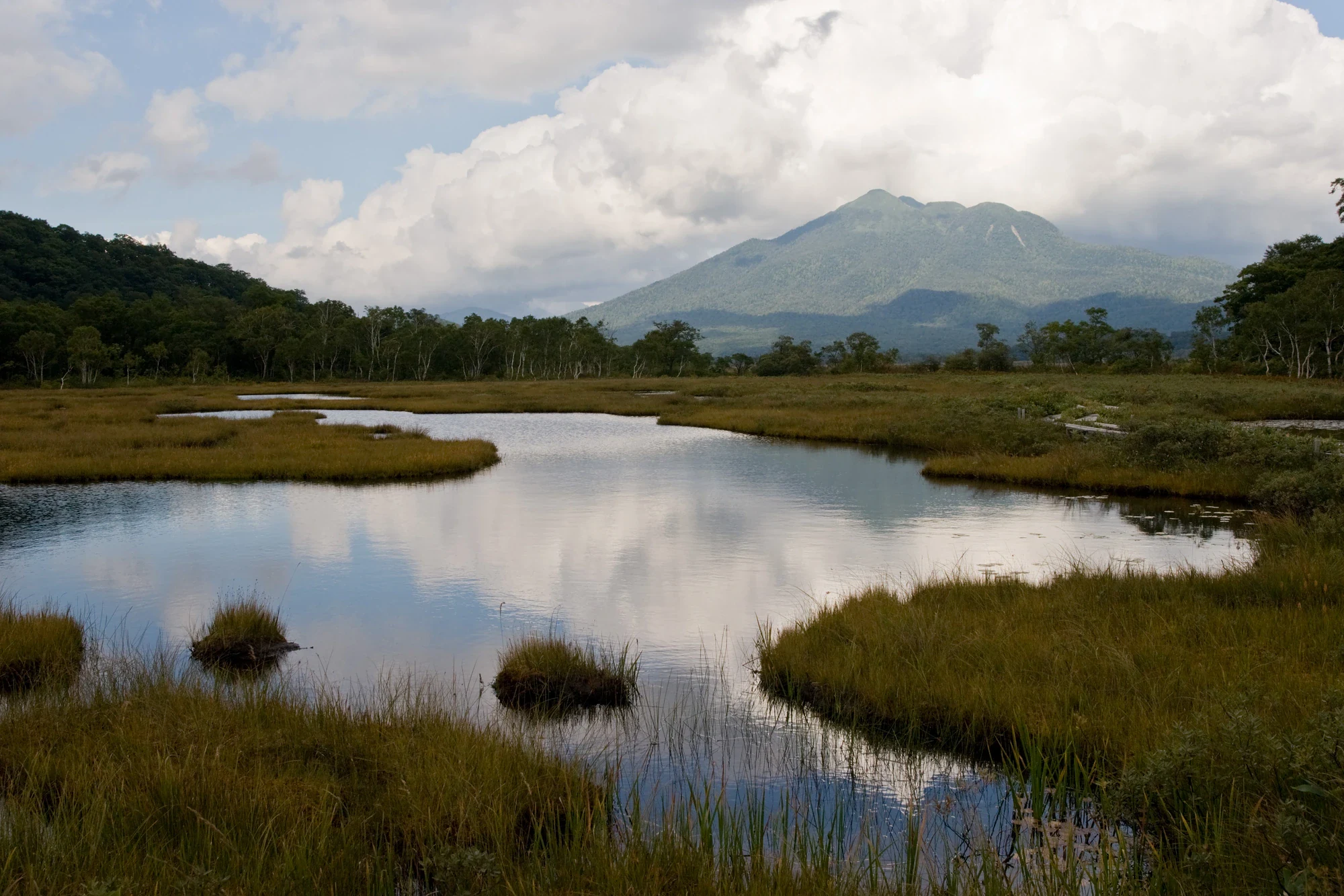
The most memorable change at Oze is the moment the trees give way to open wetland. Beyond Yamanohana, a narrow boardwalk leads between grasses and dark pools, with Mount Hiuchigatake ahead and Mount Shibutsu behind. In early summer, white mizubasho brightens the wetter ground; later come daylilies and, in autumn, the warm gold of the marsh itself. You can enjoy the mountains from below without adding a summit to your day.

This guide concentrates on Yamanohana Visitor Center and western Ozegahara, reached from Hatomachitoge Pass on the Gunma side. Oze National Park is much larger and extends across four prefectures. Lake Ozenuma, Sanjo Falls and the high peaks are separate hiking objectives, not attractions to squeeze into this introductory walk.

The approach matters. From Hatomachitoge, it is 3.3 km downhill through woodland to Yamanohana, starting with stone steps and continuing over wooden stairs and boardwalks. The return climbs back to the pass. Simply reaching the visitor center and coming back means 6.6 km of walking before any wetland loop. This is a mountain outing for people comfortable with sustained walking and uneven footing, including families with hiking experience.

At Yamanohana, check the day's trail and wildlife information, then explore the Research Botanical Garden when it is open. Its name can be misleading: this is living wetland, not planted flowerbeds. A short circuit brings pools, subtle changes in vegetation and a close view of Shibutsu into one manageable area. It makes a satisfying destination in its own right. With energy, settled weather and plenty of time before your return transport, continue toward Ushikubi junction for a broader view across Ozegahara.

Oze rewards looking carefully rather than covering every path. Watch a pool for movement, compare a round sundew leaf with the grasses beside it, or notice where open marsh meets woodland. Keep every foot, bag and tripod on the boardwalk or a designated rest area. The path is part of the conservation story: the wetland beneath it grows and recovers very slowly. Wondering what that bird or insect is? Find out on your visit using the Snappit nature app.

Oze was included in Nikko National Park in 1934 and became a separate national park in 2007. Campaigns against hydroelectric development helped make it a landmark of Japanese nature conservation. Boardwalk building began in 1952, wetland-restoration work in 1966, and a take-your-rubbish-home campaign in 1972. Those efforts explain why today’s visit is organized around paths, limited access and care for fragile vegetation.


What to do here

Hike from Hatomachitoge to Yamanohana, visit the information displays, and choose either the Research Botanical Garden circuit or an out-and-back walk toward Ushikubi. Pause at designated resting places for mountain views and close-up wetland watching. Ask whether a nature walk is running; programs and routes depend on conditions.

Seasonal info

Winter and spring bring deep snow; late-season frost can make even level boardwalks treacherous. Facilities, buses and bridges close on different dates. For 2026, Yamanohana Visitor Center is scheduled to close at 15:00 on 31 October, with reduced exhibitions and a 15:00 closing time from 19 October. Some nearby huts finish earlier. Check the detailed seasonal notes before setting out.

Accessibility

The Hatomachitoge approach has steep stone steps, wooden stairs, slopes and slippery surfaces; it is not a continuous step-free route to the visitor center. Marsh boardwalks can be narrow and raised, and some bridges have no handrails. A flat wetland photograph does not make this a wheelchair or stroller outing. Anyone needing assisted access should discuss the complete approach and evacuation needs with the operator before planning a visit.

Don't miss

1

The forest-to-marsh arrival at western Ozegahara, with Hiuchigatake ahead and Shibutsu behind

2

Yamanohana Visitor Center for the day’s nature highlights and trail advice

3

The Research Botanical Garden’s natural wetland, pools and seasonal flowers

4

A longer boardwalk walk toward Ushikubi for wide marsh views

Reflective pools wind through golden-green wetland, with a narrow boardwalk at the right and a forested mountain beneath broken cloud.

Pools and boardwalks in Ozegahara, photographed on 14 September 2009. On the Hatomachitoge itinerary, reaching Yamanohana involves a 3.3 km mountain approach each way before exploring the wetland.

Ozegahara 11.jpg — Σ64, CC BY 3.0 (https://creativecommons.org/licenses/by/3.0/). Source: https://commons.wikimedia.org/wiki/File:Ozegahara_11.jpg. Resized and recompressed as WebP; no crop or retouching. · Creative Commons

Walks and routes

Hatomachitoge to Yamanohana and back

Descend through woodland beside the Kawakami River to the visitor center, then return the same way. Stone steps near the pass make the first descent and last climb the steepest part. Use this as the minimum distance commitment, before adding any marsh exploration.

The Hatomachitoge approach includes stairs and gradients. The full outing is not step-free, and the wetland boardwalk may have raised edges, gaps and unrailed crossings.

Hatomachitoge to Yamanohana and back

Yamanohana and the outer Research Botanical Garden circuit

Combine the 3.3 km approach each way with the 1.1 km outer wetland loop. Make time for the visitor center, a rest and slow observation of pools. The inner circuit is a shorter option when open, but its shorter walking time does not remove the mountain approach.

The Hatomachitoge approach includes stairs and gradients. The full outing is not step-free, and the wetland boardwalk may have raised edges, gaps and unrailed crossings.

Yamanohana and the outer Research Botanical Garden circuit

Hatomachitoge–Yamanohana–Ushikubi out and back

After Yamanohana, follow the main marsh boardwalk to Ushikubi junction and return. Pools and the widening mountain view are the main reward. This itinerary does not include the Research Botanical Garden loop. If time or energy is tight, turn around sooner; do not continue simply because the next section looks flat.

The Hatomachitoge approach includes stairs and gradients. The full outing is not step-free, and the wetland boardwalk may have raised edges, gaps and unrailed crossings.

Hatomachitoge–Yamanohana–Ushikubi out and back

The shorter full outing

Start with an early, confirmed shuttle to Hatomachitoge. Walk down to Yamanohana, check in at the center, and choose the open Research Botanical Garden circuit. Eat at a designated resting place, then begin the uphill return with a comfortable margin before your planned bus. Allow 4–5 hours from Hatomachitoge and back plus transport; do less if the conditions demand it.

The wider marsh view

If everyone is walking comfortably and the weather is settled, continue from Yamanohana toward Ushikubi. Use the junction as a firm turnaround, not the start of an unplanned circuit. Allow 5–6 hours from Hatomachitoge and back, without the garden loop. An overnight stay can make a slower visit possible, but book a hut and check its operating dates first.

Distances combine the published sections of each itinerary. Hatomachitoge is at 1,591 m and Yamanohana at 1,400 m: the return gains 191 m between those endpoints. That is not a total-ascent measurement. The suggested visit times add room for stops to the official walking times; snow and poor footing can require a different plan.

Things to try

Let the visitor center shape the day

At Yamanohana, ask which paths are open and what is worth looking for that week. The nature displays help connect the tiny things beside the boards with the wider marsh. Guided observation walks run on some days; ask locally rather than assuming a fixed daily program.

Compare two kinds of wet ground

Walk the open Research Botanical Garden paths slowly. Its southern area includes sphagnum-rich raised bog; the vegetation changes toward wetter, lower ground to the northwest. Look for changing plant height and leaf shape without leaving the boards. This is a small-scale way to read the larger wetland.

Give one pool five quiet minutes

From a safe stopping place, watch the water for the dark shape of a newt or the movement of an insect. Japanese fire-bellied newts live in these pools; their red underside can sometimes show as they turn. Keep hands and equipment out of the water, and move on if you are blocking the boardwalk.

Frame the wetland and its mountain skyline

Beyond the forest edge, try a broad view that includes a pool, the boardwalk and the distant mountains. Calm water may add a reflection; windy weather offers a different picture in the moving grasses. Photograph from the path or a designated resting area, with no tripod legs or bags on the marsh.

Look beyond the open flower

In daylily season, compare an open bloom with the unopened buds on its stem. Those buds explain how a plant extends its display even though each flower is short-lived. In autumn, look instead for seedheads and the color of the marsh itself.

Keep the bad-weather decision at the trailhead

Yamanohana’s displays are useful once you are there, but the center is not a roadside rainy-day attraction: the same wet mountain approach still has to be walked both ways. If heavy rain, thunder, snow or ice makes that unsafe, postpone the marsh visit. If already in the area, follow staff advice and use the nearest open staffed facility rather than improvising a longer route.

Wildlife and habitats

Round-leaved sundew

Summer: look for tiny round leaves with reddish, sticky tentacles. Observe only what is visible from the boardwalk; do not touch or lure insects onto the plant.

Bogbean

In early summer, look for white flower clusters and leaves divided into three leaflets in wet ground. The protected vegetation is a useful reminder that a healthy marsh is more than its best-known flower.

Daylilies (genus)

The yellow Nikko daylily display is associated with July. Buds on the same stem open in succession, so a single flower and the wider flowering season have different lifespans. Flower abundance varies markedly.

Sika deer

Think of deer as part of the conservation story rather than an animal to feed. Their browsing and digging can damage wetland plants; protective fencing should never be crossed or disturbed.

Asiatic black bear

Oze is bear habitat, including areas near wetland boardwalks. This is a safety association, not a spotting target: follow current notices and give any bear space to leave.

Stories and discoveries

The ground has a much longer history than the path

Peat began accumulating in parts of Ozegahara about 8,000 years ago. It is built from plant material in wet conditions, not ordinary garden soil. Staying on the boardwalk protects a landscape formed over many human lifetimes.

The Research Botanical Garden is not planted

The name describes a place where different wetland features can be studied together. Pools, small rises and contrasting plant communities belong to the natural marsh.

A daylily display is a sequence

Individual Nikko daylily flowers are short-lived, while a stem carries several buds that open in succession. A hillside of flowers and a single bloom therefore run on different clocks.

A fence can be protecting flowers from deer

Vegetation-protection work at Yamanohana has aimed to shield bogbean and other wetland plants from deer feeding. Fences belong to active conservation work, so keep to the signed path rather than treating them as something to step around.

When to visit

Snowmelt and early flowers

Mizubasho is an early-season attraction, often around late May and early June. Snow can still conceal the approach and boardwalks. For a first visit, wait for a confirmed snow-free route instead of using the first road or bus opening as your hiking date.

Flowers and small wetland life

Summer brings cottongrass seedheads, daylilies and plenty to inspect beside the boardwalk. Carry rain protection even on a promising morning, and leave enough time to retreat if mountain weather deteriorates. Flower peaks move with the season and are not guaranteed.

Golden marsh, cold mornings

The marsh begins coloring before the woodland. Frost and rain can make timber slippery well before deep winter: on 15 October 2026 staff reported frozen stairs and boardwalk sections on the Hatomachitoge approach. Conditions on a later day may differ, so check fresh advice and do not hurry to meet a bus over unsafe footing.

Services end on different days

In 2026, Yamanohana’s visitor center closes at 15:00 from 19 October and is scheduled to finish on 31 October. Nearby huts have different last nights, several in mid-October. Bridge decks are removed for winter: the wider marsh’s Toden Oze Bridge is scheduled for 23 October, Yoppi Suspension Bridge for 30 October, and the Hara-no-Kawakamigawa bridge beyond Yamanohana for 5 November. Do not extend a walk onto a closed crossing. These are planned dates and can change.

Getting there and practical advice

Oze Yamanohana Visitor Center

At the western edge of Ozegahara, reached on foot. Normal listed hours are 07:00–16:00, with the information desk 07:30–16:00, during the mid-May to late-October season. Nature and trail information, displays and occasional interpretation programs are available. In 2026, hours shorten to 15:00 from 19 October and the planned final day is 31 October.

Trailhead and Yamanohana toilets

Use the toilets at the trailhead and Yamanohana rather than expecting facilities beside every marsh stretch. Carry coins for maintenance donations. The 2026 schedule lists Hatomachitoge and Yamanohana toilets through 4 November, subject to conditions; Yamanohana changes to shared use from 26 October.

Yamanohana mountain huts

Huts offer a way to split the walking over two days, but accommodation must be reserved. For 2026, the listed final overnight stays are 17 October at Oze Lodge, 18 October at Yamanohana-goya and 29 October at Shibutsusanso. Confirm directly before relying on beds, meals or daytime services.

Reach Tokura first

The Gunma-side public-transport approach runs from Jomo-Kogen or Numata Station to Oze Tokura, then by shuttle or shared taxi to Hatomachitoge. Check both legs and the return connection; reaching the pass is only the start of the walk.

Park and transfer

Private cars and motorcycles are prohibited year-round on the Tsunagi–Hatomachitoge section. Use the Tokura parking arrangements and the permitted shuttle/shared taxi. The 2026 published shuttle fare is ¥1,300 adult or ¥650 child each way, and the timetable journey is 35 minutes. Parking and onward buses are extra.

2026 transport and road cutoffs

The Tokura–Hatomachitoge shuttle is scheduled from 18 April through 3 November 2026. From 19 October, the published last departure from Hatomachitoge is 15:30. No shuttle runs on 4 or 5 November. The prefecture schedules winter road closure from 5 November at 14:00, with reopening provisionally 16 April 2027 at 10:00. Weather can change access earlier; road reopening does not lift the private-car restriction or establish safe hiking conditions.

Check the entire journey

The main obstacle is reaching the wetland: the mountain trail starts with steep stone stairs and has further wooden steps. Within Ozegahara, level sections still include narrow, raised boardwalks and some unrailed river crossings. If you need accessible transport, toilets or indoor facilities, ask the operator about each part of the journey before you travel. Do not arrive expecting an independent wheelchair or stroller route.

Sources and useful links

Wildlife you might spot

5

Each card links to a full Explore page with photos, traits, and fun facts.

Snap map for this place

Start with the big picture, then zoom in to explore individual wildlife observations around this place.

Loading map…

Good to know before you go

Choose your turnaround before leaving Hatomachitoge. The return to the pass is uphill, and buses do not collect walkers from Yamanohana.

Use the day’s shuttle timetable. Private cars and motorcycles cannot drive the restricted Tsunagi–Hatomachitoge section; park in Tokura and transfer.

Wear well-fitting footwear with good grip, and carry waterproof layers, warm clothing, water, food, a headlamp and an offline map. Do not depend on mobile reception.

Walk on the right, give uphill walkers priority, and stop where others can pass. Wet or frosted timber needs particular care; watch your feet before looking at the view.

Check bear notices at the trailhead and visitor center. Use the recommended bells to announce your presence; if you meet a bear, stay calm, do not approach or photograph it, and retreat slowly without running.

Never step into the marsh, pick plants, feed animals or leave food scraps. Clean mud and seeds from your shoes at the entrance mats, and leave pets at home.

Bring Japanese coins for toilet-maintenance donations and check which toilets are operating. A hut’s accommodation season does not guarantee its café or toilet is available.

Reserve a mountain hut before an overnight trip and confirm its final operating date. If snow, thunderstorms or an unsafe boardwalk threaten the plan, shorten the walk or postpone it.

Frequently asked questions

No. On this approach, take the permitted shuttle or taxi service from Tokura to Hatomachitoge, then walk 3.3 km to Yamanohana. Return by the same uphill trail. The vehicle stop and visitor center are different places.
Make Yamanohana and an open Research Botanical Garden circuit your destination. The approach alone is 6.6 km return. With the 1.1 km outer circuit, plan for about 7.7 km and 4–5 hours from Hatomachitoge and back, plus transport. Turn back earlier if footing, energy or weather is deteriorating.
Only if the whole party can manage the mountain approach, an uphill return and narrow boardwalks safely. Keep children close beside pools and unrailed crossings. A short loop at Yamanohana still comes after a substantial approach; a stroller is not a practical substitute for walking.
No. Bears also use wetland edges and may cross boardwalks. Follow local closures and staff instructions throughout the visit, including in the Research Botanical Garden. Do not seek a sighting or approach cubs.
Treat them as separate, longer hiking plans. This introduction ends in western Ozegahara. A mountain-hut reservation, a different trailhead or an additional day may be more sensible than stretching a day trip.
No. Visitor centers, huts, toilets and bridges have separate closing dates. In 2026 the Tokura–Hatomachitoge shuttle is scheduled through 3 November, after the visitor center’s planned 31 October closure and several hut closures. Transport availability is not a promise of services on the trail.

Recent snaps at this place

Recent snaps will appear here as new observations are added.

View all ›

Take the discovery with you

Exploring Oze National Park?

Identify the wildlife you spot, learn as you go, and keep a collection of the adventure.

  1. 1Spot it
  2. 2Snap it
  3. 3Keep the discovery