
Snappit logo
Snappit
Get App
Generic illustration, not a photograph of this venueIllustration
ParkShikoku, Japan

Tsurugisan Quasi-National Park

Tsurugisan is a mountain day with a useful choice built in.

About

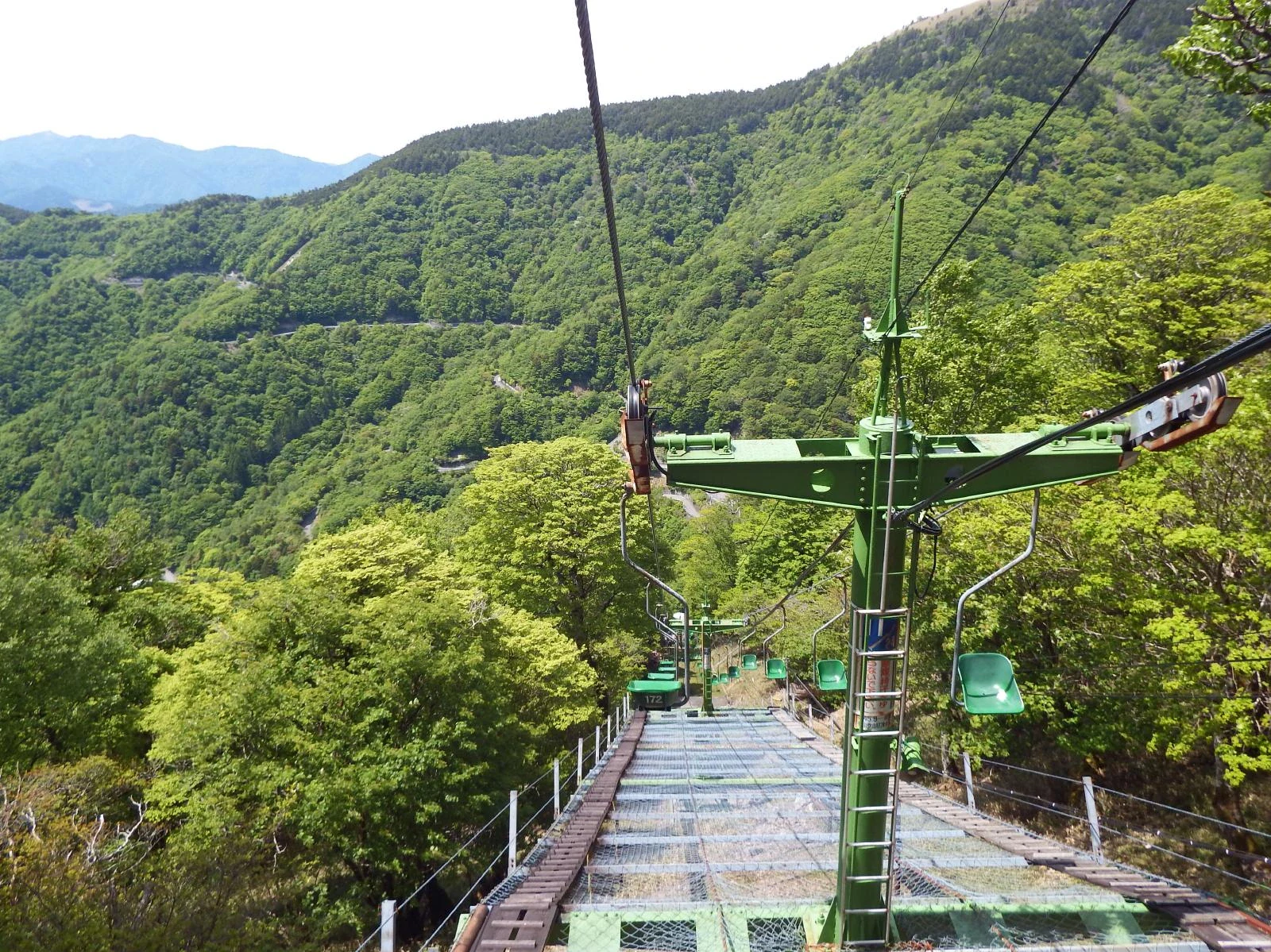
Tsurugisan is a mountain day with a useful choice built in. From Minokoshi, the open chairlift carries you up through forest to Nishijima. You can pause there, enjoy the changing layers of woodland and distant ridges when the sky clears, and ride back down. The summit is an optional walk beyond the lift, rather than the price of admission to the scenery.

The wider quasi-national park stretches across Tokushima and Kochi, taking in high mountains and deep valleys. This visit stays on the Tokushima side, at Minokoshi and the northern approach to the 1,955-metre Mount Tsurugi. It is a different mountain from Toyama’s Mount Tsurugi in the Northern Alps.

The lift climbs from 1,420 to 1,750 metres in about 15 minutes. Notice how broad-leaved forest gives way to a more conifer-rich mountain landscape. If everyone has suitable shoes, energy and a settled forecast, the signed ridge course continues uphill to the summit. Above the trees, wooden paths protect low bamboo vegetation, and the neighbouring ridges become the main attraction.

Keep the mountain’s scale in mind. Even the lift gateway is high above the valleys, while the summit walk has rough ground, climbing and exposure to wind. A short visit that ends with a warm drink at Minokoshi can be just as satisfying as reaching the top. Decide your return time before you start, especially if a seasonal bus is taking you home. Be ready to snap and learn! Get the Snappit app to identify any nature species you find here.

Tsurugisan Quasi-National Park was designated on March 3, 1964. The mountain’s religious history is much older: shrines and pilgrimage traditions are woven into its slopes, and several stories explain its name, including a legendary imperial sword. Those stories are part of the mountain’s culture rather than one settled historical explanation. The sightseeing lift began operating in 1970.

What to do here

Start at Minokoshi with toilets and a check of the lift and trail conditions. Ride to Nishijima, pause clear of the boarding area, and decide whether to stay near the station or take the optional summit hike. Return by the same lift; leave longer ridge traverses for a separately planned walking day.

Seasonal info

The published 2026 lift season runs from a planned April 18 opening to November 30, subject to conditions. Ordinary hours are 09:00–16:30; Golden Week, August 1–31 and October weekends/public holidays start at 08:00. Winter brings snow, closed facilities and road restrictions, so this lift-assisted plan is for the operating season.

Accessibility

This is a single-seat open chairlift, followed by mountain terrain if you continue walking. It does not provide a step-free route to the summit. Before travelling with a wheelchair, limited balance or young children, ask the operator about boarding and assistance arrangements. The summit hike is unsuitable for pushchairs.

Don't miss

1

A 15-minute open-chair ride from Minokoshi to Nishijima

2

Beech-rich woodland and the changing forest higher on the mountain

3

An optional summit walk to broad views and bamboo-covered ridges

4

A compact gateway stop for local information and a warming drink

Green open chairs and a lift tower descend above a safety net, with forested mountain slopes beyond.

The Tsurugisan sightseeing chairlift above the forested slopes, photographed in May 2022.

Turugisantozanrihuto20220528 1.jpg — Dokudami, CC BY-SA 4.0 (https://creativecommons.org/licenses/by-sa/4.0/). Source: https://commons.wikimedia.org/wiki/File:Turugisantozanrihuto20220528_1.jpg. Proportionally resized to a maximum 2000-pixel long edge without upscaling; recompressed as WebP quality 92, method 6. No crop, added text, colour adjustment or retouching. Original retained as working evidence only; EXIF omitted from derivative. · Creative Commons

Walks and routes

The shorter choice: Minokoshi to Nishijima

Ride up and down, with a short pause around the upper station only where staff and signs permit. The changing forest is the focus. Keep the walk modest and leave time for a drink or information stop back at Minokoshi. Allow 1½–2 hours altogether.

Open-chair boarding is part of the outing. Ask about individual support needs before travelling; the station surroundings should not be assumed level or step-free.


The shorter choice: Minokoshi to Nishijima

Optional hike: Nishijima to the summit and back

Take the signed Onemichi ridge course and return the same way. The official ascent is 900 metres in about 40 minutes; allow 60–90 minutes going up at a gentler pace and 2–3 hours for the whole upper-station hike with a summit pause. The return walk is about 1.8 km, before any extra wandering at the top.

This is a climbing route over uneven mountain ground, with exposed conditions near the top. It is not wheelchair- or pushchair-accessible; summit decking does not remove the climb needed to reach it.

Optional hike: Nishijima to the summit and back

A gentle-paced gateway visit

1½–2 hours, plus road or bus travel

Check the return journey and lift status at Minokoshi, then use the toilets.

Ride to Nishijima and take a short, unhurried pause in a permitted area.

Return by lift and stop for local information or a drink if the centre is open.

A summit day with room to turn back

3–4 hours, plus travel and any queues

Arrive in the morning with hiking equipment and a return deadline.

Take the lift and assess the optional ridge walk at Nishijima.

If conditions and energy suit, walk to the summit and return on the same course.

Reach the upper lift station comfortably before your planned descent; allow extra time if you have a bus to catch.

Things to try

Watch the forest change

Compare the leafy woodland below with the darker evergreen trees higher up. Make your observations once safely off the lift, without stopping in the boarding or exit area.

Make a small colour collection in a notebook

Choose three colours you can see from the path and sketch them: perhaps bark, a leaf and a distant ridge. A drawing brings the detail home without taking anything from the mountain.

Let the summit be a decision, not a promise

At Nishijima, check the time, wind and everyone’s energy together. If the answer is a shorter day, take it. You have already climbed into the mountain landscape by lift.

If you are already at Minokoshi

When the weather turns, ask staff about conditions and the return journey. An open café can offer a pause, but do not wait out worsening mountain weather just to keep the original plan.

If you have not set off

Keep the day in the valley or choose an indoor visit near your accommodation, then save Tsurugisan for a settled forecast. Heavy rain can affect the approach roads as well as the trails.

Wildlife and habitats

Beech woodland

The woods around Minokoshi include beech. Look at the shapes of trunks and the way light falls through the canopy rather than hunting for one particular tree. Fresh leaves and autumn colour give the same woodland very different moods.

Maples among the forest trees

Maples are part of the mountain’s mixed woodland. Compare leaves still on nearby branches, then look up to see how broad-leaved crowns sit beside conifers. Leave fallen leaves and other natural objects where they are.

Eurasian wren

Listen for a surprisingly strong, complicated song from a very small bird. Wrens often keep low in woodland, near ground cover and fallen wood. Stay on the trail and let the sound come to you rather than searching through the undergrowth.

Sika deer and the forest’s protective fences

Deer live in these mountains, but their browsing also damages vegetation. Tree guards and protective netting are part of caring for the forest. Leave them untouched, and if deer appear, watch from a distance without offering food.

Enjoy the forest first and treat any animal encounter as a bonus. Watch from the path, keep your distance and never feed or call animals closer. The short lift outing does not cover every habitat described below.

Sharing the mountain with bears

Tokushima’s current advice is to check sightings, avoid affected areas where possible, walk in a group and carry a bear bell. Take all food scraps home. Turn back if you find fresh signs. If you see a bear, do not approach for a photograph or offer food; back away slowly without running or turning your back. Never approach a cub.

Stories and discoveries

A landscape lifted from the sea

Limestone and chert in the Tsurugi mountains tell a much older story than the forest: these rocks formed in marine settings before the land was raised into mountains.

The wooden paths have a job to do

The summit’s decking helps protect the low-growing vegetation from too many footsteps. Staying on it is part of looking after the view you came to enjoy.

When to visit

Spring and early summer

Wait for the season’s confirmed reopening. Snow and cold can linger even when the valley feels mild. The woodland’s new leaves are a reason to slow down, while the June Sadamitsu bus gap needs separate travel planning.

Summer

Look for flowers from the trail, carry water, and retain a warm layer and waterproofs. Summer does not remove the risk of cold wind, fog or thunderstorms high on the mountain.

Autumn into winter

Early to mid-October is a usual colour window, with timing changing each year. Start early enough for queues and a daylight return. After seasonal services close, snow and ice turn this into a winter-mountaineering setting rather than the outing described here.

Getting there and practical advice

Minokoshi lift tickets

The operator’s current cash-only fares are ¥2,300 adult / ¥1,100 child return, or ¥1,300 adult / ¥650 child one way. Prices were checked on October 16, 2026. Confirm child eligibility and any assistance needs directly on 0883-67-5277.

Tsurugisan Tourist Centre

At the Minokoshi gateway, the centre offers walking information, souvenirs, coffee and light food. The current regional listing gives 11:00–16:00, with winter closure from December to mid-April. Check before relying on a meal or an early opening.

Toilets and the summit hut

Use the trailhead toilets before starting. The summit eco-toilet requests a ¥100 contribution and closes in winter. The summit hut is a seasonal facility reached by hiking; check its own opening information rather than counting on food or shelter there.

By car to Minokoshi

From Mima IC, allow about 90 minutes via National Route 438 and extra time for narrow sections and oncoming traffic. Roads also approach through Iya, but check the chosen route’s restrictions before leaving. Use designated parking only; roadside parking can block buses and residents.

The Sadamitsu bus: plan the return first

In 2026 the Sadamitsu–Ichiu service is scheduled on weekends and public holidays April 18–May 31 and July 4–November 15, plus daily August 8–16. It does not run in June. The useful morning trip leaves JR Sadamitsu at 07:50 and reaches Minokoshi at 09:24; the afternoon return leaves at 13:45. The adult through fare is ¥3,000 each way, cash only. Check the current timetable and transfer arrangements before travel.

From Awa-Ikeda or Ōboke

The Ikeda–Higashi-Iya service has a different calendar and involves checking the connecting services through Iya. Use its current timetable, rather than applying the Sadamitsu dates or departure times. If buses do not suit your day, book a taxi in advance; do not depend on finding one at Minokoshi.

Open-chair boarding

The lift is not an enclosed gondola. Ask the operator how boarding works for your group, including children, wheelchair users and anyone who needs support with balance or transfers. No wheelchair boarding arrangement should be assumed from a photograph.

Walking and facilities

For a step-free day, do not choose the summit plan. Contact the gateway facilities about parking, entrances and accessible toilets before making the long drive; the available visitor pages do not give enough detail to plan those needs confidently.

Sources and useful links

Wildlife you might spot

4

Each card links to a full Explore page with photos, traits, and fun facts.

Snap map for this place

Start with the big picture, then zoom in to explore individual wildlife observations around this place.

Loading map…

Good to know before you go

Check the operator, mountain forecast and road notices before setting out. Heavy rain, strong wind, thunder or poor visibility are good reasons to postpone.

Bring grippy walking shoes, water, food, waterproofs, a warm layer and a headtorch. The town warns that summit temperatures can be more than 10°C below the lowlands.

Plan backwards from your bus and the day’s last lift. The 2026 afternoon Sadamitsu-bound bus leaves Minokoshi at 13:45, well before the lift closes.

The lift takes cash only. As checked on October 16, 2026, return fares are ¥2,300 for adults and ¥1,100 for children; ask the operator which child category applies.

For the summit hike, share your plan and submit a climbing notification. There is a submission box at the Minokoshi lift boarding area; follow current local instructions.

Use toilets before ascending. Keep children close on uneven ground, and turn back if anyone becomes cold, tired or unwell.

Bears live in the Tsurugi mountain system. Check recent advice, walk together in daylight, make your presence known with a bell, and carry every scrap of food and litter out.

Stay on paths and summit decking. Leave plants, rocks and wildlife undisturbed, keep protective tree guards in place, and cover exposed skin against ticks, especially April–September.

Frequently asked questions

No. It ends at Nishijima, at 1,750 metres. The 1,955-metre summit still requires an uphill mountain walk. The shortest published course is 900 metres one way, with an official ascent time of about 40 minutes; slower walkers should allow longer.
Yes. Make the return lift ride and a modest stop around Nishijima your whole outing. Ask staff where to wait or pause safely, and avoid committing to a trail if the footing or weather feels wrong.
It can be, when everyone is comfortable with the open chairlift, appropriately dressed and happy to turn back. Choose the short plan first. The summit is a hiking option for those ready for climbing, rough footing and exposed weather.
No. Each seasonal bus route has its own calendar and early last departure. Check both directions before booking the day; on a non-running day, a taxi needs advance arrangement.
If heavy rain, thunder or strong wind is forecast, move the mountain visit to another day. A coffee stop at Minokoshi is useful if you are already there and it is safe to travel, but it is not a reason to drive up during bad weather.
Those are separate mountain hikes with extra distance, ascent and exposure. They are outside this short visit. Plan them with an appropriate map, equipment, daylight and current trail advice rather than adding them on spontaneously.

Recent snaps at this place

Recent snaps will appear here as new observations are added.

View all ›

Take the discovery with you

Exploring Tsurugisan Quasi-National Park?

Identify the wildlife you spot, learn as you go, and keep a collection of the adventure.

  1. 1Spot it
  2. 2Snap it
  3. 3Keep the discovery




