
Snappit logo
Snappit
Get App
Generic illustration, not a photograph of this venueIllustration
ParkKR

Chiaksan National Park

Chiaksan rises across Wonju and Hoengseong in Gangwon State.

About

Chiaksan rises across Wonju and Hoengseong in Gangwon State. Its highest summit, Birobong, reaches 1,288 m, but much of the pleasure of a first visit lies below it. The Guryong entrance is a useful starting point for a day built around woodland and temple history. Beyond Seryeom Waterfall, steep stairs and rocky mountain terrain change the character of the outing. Decide in advance where you will turn around, and keep enough time for the return to your actual bus stop or car park. Wondering what that bird or insect is? Find out on your visit using the Snappit nature app.

Chiaksan became Korea’s sixteenth national park on 31 December 1984. Its cultural landscape is much older. Guryongsa’s traditional foundation story places the monk Uisang here in 668, and the tale of nine dragons explains the temple’s name. Treat that as a founding tradition, rather than the age of every building you see. Bogwangnu belongs to the late Joseon period; evidence found during its 2008 restoration suggests 1707 or earlier.

What to do here

Walk through the pine forest to Guryongsa, look at Bogwangnu Pavilion, and continue toward Daegok and Seryeom Waterfall if the route is open and everyone has the energy. Around Guryongsa, the fir-forest option offers a broader, more even path than the narrower herb-garden path. A summit climb should be planned as its own mountain day.

Seasonal info

Check trail controls and the mountain forecast on the day. Autumn crowds can slow the approach, and winter entry cutoffs arrive earlier. Seasonal booking arrangements apply to certain Hyangnobong approaches elsewhere in the park; they are separate from the Guryong valley walk.

Accessibility

The approach includes a pedestrian deck separated from the road, followed by unpaved paths. Stone surfaces and protruding rocks remain an issue farther up the valley. The waterfall walk is easier than a summit ascent, but it is not a verified continuous wheelchair route. Ask staff about a suitable short section, toilets and current surface conditions.

Don't miss

1

Guryongsa and its historic Bogwangnu Pavilion

2

Pine forest and the old Hwangjanggeumpyo timber-protection marker

3

A valley walk through the Daegok area to Seryeom Waterfall

4

Birobong’s stone towers for properly prepared mountain walkers

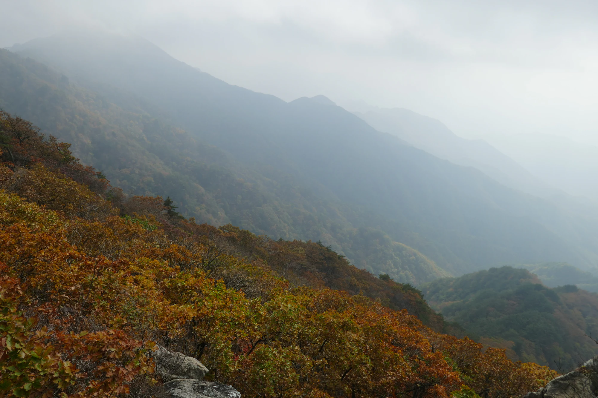
Autumn-coloured wooded slopes and foreground rocks beneath layered mountain ridges fading into pale mist.

Autumn ridges in Chiaksan, photographed in October 2023 from a viewpoint the photographer describes as between Hyangnobong and Namdaebong. This is the park’s higher-ridge landscape, not the Guryong valley walk. The exact day is uncertain, and the image does not show current conditions.

“2023--15 October--Hike in Chiaksan National Park, Korea--Birobong, Hyangnobong, and Namdaebong” by Phil Venditti (LittleRoamingChief), CC BY 2.0. Unchanged original. · Creative Commons 1 · Creative Commons 2

Walks and routes

A shorter outing: Guryongsa and the pine forest

Start with the information point at the Guryong entrance, then take the pedestrian route toward the temple. The decked approach keeps walkers apart from the road; beyond the Iljumun gate the surface becomes unpaved. The pine-lined section gives this walk its distinctive atmosphere, and the temple is a satisfying destination even if you go no farther.

Spend time around Bogwangnu and the courtyard, then return by an open signed route. This is the best choice when you want to linger over architecture, have young children with you, or are unsure about the group’s walking range. The suggested 1½–2½ hours includes a leisurely temple stop, not a fixed trail-time promise.


The longer forest walk: Guryong to Seryeom Waterfall

Follow the signed sequence Guryong Visitor Support Center → Guryongsa → Yongso → Daegok Safety Center → Seryeom Waterfall. The official course profile gives 3.3 km and 1½ hours to the waterfall. Add the return journey: walking back the same way makes about 6.6 km, calculated from the one-way distance. Temple visits, rests and the approach from your parking place take extra time.

Between Guryongsa and Daegok, choose the fir-forest path when open if you prefer a broader and more even surface. The herb-garden path is narrower, with protruding stones; the fir route is a little longer. Beyond Daegok, expect unpaved ground and some stone-laid sections. Stop at the designated viewing area rather than scrambling toward the falling water. For a valley day, this is your turnaround point.

The longer forest walk: Guryong to Seryeom Waterfall

A separate mountain day: Birobong via Sadaribyeongchang

The published Guryong–Birobong course is 6 km and about 3½ hours uphill, through the lower valley and then Sadaribyeongchang. A same-route return is about 12 km by simple doubling, before extra approach walking. The upper ridge route from Seryeom is 2.7 km of much steeper terrain, with extensive stairs and rocky, exposed sections. Plan the descent as carefully as the ascent.

Go only with suitable fitness, mountain footwear, warm and waterproof layers, food, water and enough daylight. Birobong’s three stone towers are a summit landmark, but poor visibility or weather may remove the view. Turn around early if the group is slowing or conditions deteriorate. Do not substitute the upper valley route when the ridge feels too difficult: that valley is named in the rockfall-control notice.

A separate mountain day: Birobong via Sadaribyeongchang

Other entrances need their own plan

Chiaksan is one large park with several approaches. Bugok is on the Hoengseong side; Haenggu leads toward Hyangnobong; the southern Geumdae and Seongnam approaches serve a different part of the mountain. They are alternatives for another planned outing, not convenient exits back to a Guryong car.

For Hyangnobong, check the seasonal reservation page for your particular approach. It currently lists managed periods of 3 March–30 April and 15 November–15 December for specified sections from Godeunjae, Haenggu and Bugok. Other controls can override those arrangements. Before a traverse, arrange transport from the actual exit rather than assuming a shuttle links all entrances.

Putting a half-day together

Check controls before leaving, then confirm your turnaround point at Guryong. Walk to the temple first and decide there whether the group still wants the waterfall. If you continue, take the fir-forest option when available, pause in the Daegok area and leave enough energy for the return. If you finish at the temple, use the spare time for a meal outside the walking route rather than adding an unplanned summit.

Things to try

Look closely at Bogwangnu

The pavilion explains how a mountain temple can work with sloping ground: the approach traditionally passes beneath its upper floor into the main courtyard. Its five-bay frontage and two-bay depth give it a broad, sheltering presence. Wonju’s heritage account notes that it survived the Korean War and that the 2008 restoration retained much of its older timber. Look from the permitted visitor area; a historic passage or room is not automatically open for exploration.

Find the forest’s older story

The Hwangjanggeumpyo marker records a Joseon-era ban on cutting valuable pine timber. Its purpose was practical: protect good wood, with nearby administrative oversight and river routes for transport. Reading the marker gives the tall pines a human history as well as a visual appeal. Enjoy the inscription and any interpretation from the path; do not rub, trace or climb on it.

Ask about guided nature activities

Guryong Visitor Support Center is the place to ask about interpretation programmes and today’s route conditions. Daegok’s plant-observation area appears in the park’s route guide, but access and organised activities can change. Confirm what is actually available before making it the centre of a child’s day, and book any advertised session through the official service.

When the mountain is not the right choice

In light rain, a short temple approach may still suit an equipped group if staff confirm that it is safe and open. Guryongsa is an active temple, not a guaranteed indoor refuge for a whole wet-weather day. Heavy rain, thunder, ice or strong wind are reasons to postpone the walk and spend the day in Wonju instead. Never treat a lower route as automatically exempt from a weather closure.

Wildlife and habitats

Pine

The pine forest between the Iljumun gate and Guryongsa is one of the lower walk’s defining features. Look up at the trunks and evergreen canopy before continuing to the temple. These are the locally celebrated Geumgang pines; the old timber-protection marker helps explain why the woodland mattered. Leave cones, needles and branches in place.

Fir

The fir-forest path between Guryongsa and Daegok offers a useful contrast with the pine approach. Take this open signed option for its broad path and substantial trees, rather than trying to turn an informal gap through the woods into a shortcut.

Siberian chipmunk

Chipmunks have been photographed elsewhere in Chiaksan, including below Bomunsa on the Haenggu–Hyangnobong approach. That makes them part of the park’s woodland story, not a guaranteed encounter on the Guryong route. If one appears, stop at a distance and let it move away; never use snacks to bring it closer.

A stream specialist and a mountain flower

The park highlights the Korean water toad and diamond bluebell among its flagship wildlife. The toad is associated with stream valleys, while the bluebell has pale-purple, hanging bell-shaped flowers. Look for interpretation rather than searching off-trail for a specimen. Do not lift stream stones, handle amphibians or pick flowers; the quietest visit is usually best for these habitats.

Stories and discoveries

Nine dragons, one temple name

Guryongsa’s founding legend tells of nine dragons living in the water where a monk wanted to build a temple. In the story, the dragons depart after a contest of powers. The tale is part of the place’s cultural identity, not an explanation of its geology. The temple’s current Chinese-character name uses the character for turtle where an older version used “nine,” giving the nearby turtle-rock tradition another connection to the name.

When to visit

Spring

Fresh woodland growth and the park’s spring flowers make a lower-valley walk rewarding. Higher paths can retain cold or slippery conditions after the city feels mild. Check fire-season restrictions and any seasonal reservation for a different entrance before setting out; stay on the path even when flowers are just beyond it.

Summer

Use the shade for a slower forest outing, but carry water and start with a heat-aware plan. After heavy rain, a waterfall visit can be unsafe rather than more attractive. Avoid the stream edge and obey weather closures. If thunder or rapidly rising water is a concern, choose another day instead of waiting beneath trees in the valley.

Autumn and winter

Autumn brings leaf colour and busier access roads, so leave room for parking delays and a slower return. Colour varies with elevation and weather; the historical ridge photograph is not a prediction for your date. In winter, use appropriate traction for icy mountain terrain and shorten the objective if your equipment or experience is limited. A frozen path can make a temple visit demanding even when the summit is not in your plan.

Getting there and practical advice

Facilities, food and camping

Use the entrance information point to locate toilets and check which facilities are open. The summit route guide identifies the toilet by the native-plant observation area as the last one before the upper climb, so do not leave that decision until the ridge. Bring drinking water rather than treating stream water as a refill source.

Guryong and Geumdae have bookable campsites, with separate tariffs and rules. Reserve the site you intend to use; a camping booking is not permission to pitch a tent beside the trail. Check current charges at your chosen car park and facilities.

Arrive on the Guryong side

For this walk, use 구룡탐방지원센터 (Guryong Visitor Support Center) or a named Guryong-area car park. KNPS lists the centre at 26 Musoejeom 2-gil, the Guryong car park at 44 Musoejeom 2-gil, and Sinheungdong parking at 425 Guryongsa-ro, all in Socho-myeon, Wonju. These are separate arrival points; allow for the walk between where you arrive and where the trail distance begins.

The park’s bus directions name Wonju bus 41 to the Guryongsa terminus. Check the current route, stop direction and final return service before travelling, especially if connecting from a train or intercity bus. Do not plan a summit descent against an old published bus journey time.

Autumn 2026 parking shuttle

A seasonal notice schedules a Guryong-area shuttle on weekends and public holidays from 3 October to 15 November 2026, between 08:30 and 17:30, roughly every 20–30 minutes depending on demand. It links the park-office and parking area, including Sinheung and Guryong large-vehicle parking; it does not carry you to Seryeom Waterfall. The operator asks visitors to give downhill seats to children and others who need them more. Confirm the day’s service before relying on it, and expect a wait during busy foliage weekends.

Choose a manageable section, not a label

“Easy” on a mountain route is a comparison, not a guarantee of step-free travel. The lower approach changes from deck to unpaved ground, and the two paths beyond Guryongsa have different surfaces. If using a wheelchair or stroller, ask the park office which stretch is suitable for your equipment and whether bridge works or temporary diversions affect it. Plan a short return route first. The fir-forest option may offer easier footing for walkers, but its entire approach has not been verified as independently wheelchair-accessible.

Visitor information

Check the upper-valley restriction before a summit trip

The detailed KNPS notice checked on 18 October 2026 gives a start time of 04:00 on 19 October and no fixed end date. It names rockfall restrictions on Seryeom Waterfall–Biro Junction and Yeongwonsa–Namdaebong Junction, alongside unfinished trail sections near Seopjae and Ttwarigul. The attached map distinguishes the upper Guryong valley route from Sadaribyeongchang. Confirm the latest restrictions and the lower waterfall route with the park office on +82-33-740-9900 before travel, and follow all posted barriers.

Sources and useful links

Wildlife you might spot

3

Each card links to a full Explore page with photos, traits, and fun facts.

Snap map for this place

Start with the big picture, then zoom in to explore individual wildlife observations around this place.

Loading map…

Good to know before you go

Save the Guryong entrance or car park as your destination. A search for “Chiaksan” alone can send you to a different side of the mountain.

Wear footwear with a reliable grip, including on the lower forest walk. Wet timber and rocks can be slippery.

Carry water and food for your chosen route, and allow a generous margin before your last onward connection.

Use the designated waterfall viewpoint and paths. Do not climb wet rocks or enter closed streamside sections for a photograph.

Keep food away from wildlife, leave flowers and cones where they are, and take your litter out.

Give worshippers space at Guryongsa, keep voices low and follow local photography instructions.

Frequently asked questions

The published course starts at Guryong Visitor Support Center, not at every possible parking space. Its profile gives 3.3 km to the waterfall and 1½ hours in that direction. Returning the same way makes about 6.6 km before any extra approach walking, so allow a half-day rather than treating it as a quick photo stop.
Only if you planned and equipped for the summit from the outset. The Sadaribyeongchang route climbs steeply, with many steps and exposed rocky terrain. If your plan was a family valley walk, turn back at the waterfall; reaching it comfortably does not tell you how the upper mountain will feel.
The notice posted on 1 August 2026 covered a 40 m bridge-area maintenance closure on 4–5 August and allowed passage around Guryongsa. It does not establish later bridge access. Check the latest detailed controls and local signs for your travel date.
Check separately for camping, guided programmes and seasonally managed trails. The Hyangnobong reservation page covers specified approaches and dates; it is not a booking rule for every path in Chiaksan. Confirm your exact route before reserving accommodation or transport.

Recent snaps at this place

Recent snaps will appear here as new observations are added.

View all ›

Take the discovery with you

Exploring Chiaksan National Park?

Identify the wildlife you spot, learn as you go, and keep a collection of the adventure.

  1. 1Spot it
  2. 2Snap it
  3. 3Keep the discovery




