
Snappit logo
Snappit
Get App
Generic illustration, not a photograph of this venueIllustration
ParkCantabria, Spain

Dunas de Liencres y Costa Quebrada Natural Park

At Liencres, the interesting part is the meeting of things: waves and sand, dunes and woodland, the river Pas and the open sea.

About

At Liencres, the interesting part is the meeting of things: waves and sand, dunes and woodland, the river Pas and the open sea. Start around the Canallave and Valdearenas access areas and give yourself time to notice the changes. A dune with just a few plants on it can be as revealing as the broad coastal view.

For a first visit, keep the plan simple. Use the designated beach approaches, look along Valdearenas from a safe place, then add a short section of an open, marked pinewood path if conditions suit. You can enjoy the landscape without crossing the dune vegetation or attempting a long coastal hike. The sea is powerful here; a walking visit is rewarding in its own right.

The natural park became much larger in 2021. Today's protected area includes coast, the Pas estuary and inland ground across three municipalities, beyond the original dunes-and-pines park created in 1986. Costa Quebrada also belongs to a wider UNESCO Global Geopark designated in 2025. That recognition gives the landscape useful geological context, but its boundary is different from the natural park's.

This guide concentrates on the Liencres beach-and-woodland end of the park. Save the longer cliff routes and the inland hills for a separately planned walk. A modest outing leaves more time for the small details: patches of sand-loving plants, wind marks and the sound of the surf behind the trees. Eager to name that creature? Identify any animal you find during your visit using the Snappit app.

The original Dunas de Liencres Natural Park was declared in 1986 to protect the dune system at the mouth of the Pas, its beaches and adjacent pinewood. The woodland itself reflects an earlier intervention: maritime pines were planted to hold moving sand. Law 2/2021 established the enlarged Dunas de Liencres y Costa Quebrada Natural Park, covering 1,753.14 hectares in Piélagos, Miengo and Santa Cruz de Bezana. The wider Costa Quebrada UNESCO Global Geopark followed in 2025; it is a separate designation, not a UNESCO World Heritage listing for these dunes.

What to do here

Begin at the official access area for Canallave or Valdearenas, read the notices and choose a short out-and-back on the paths that are open. Compare the dune edge with the pinewood, watch the sea from well back and pause to identify a few plants. If you want a longer walk or closer interpretation of the coast, ask Naturea about a suitable guided outing.

Seasonal info

Summer brings more visitors and seasonal services. The published 2026 lifeguard season finished on 27 September, so an October visit should be planned as a shore walk. In the wetter months, allow for slippery ground, stronger seas and fewer daylight hours. Check the latest notices before every visit.

Accessibility

Soft sand and uneven woodland ground can make a short outing demanding. Canallave has had access stairs and a wooden ramp installed, but this does not establish a continuous step-free route or access across the sand. Ask the Liencres tourism office about the current ramp, parking, surface, gradients and accessible toilets before travelling with a wheelchair or pushchair.

Don't miss

1

The broad sand-and-sea view at Valdearenas

2

Dune plants that survive shifting sand and salt-laden wind

3

The contrast between open shore and planted pinewood

4

An introduction to the wider Costa Quebrada landscape

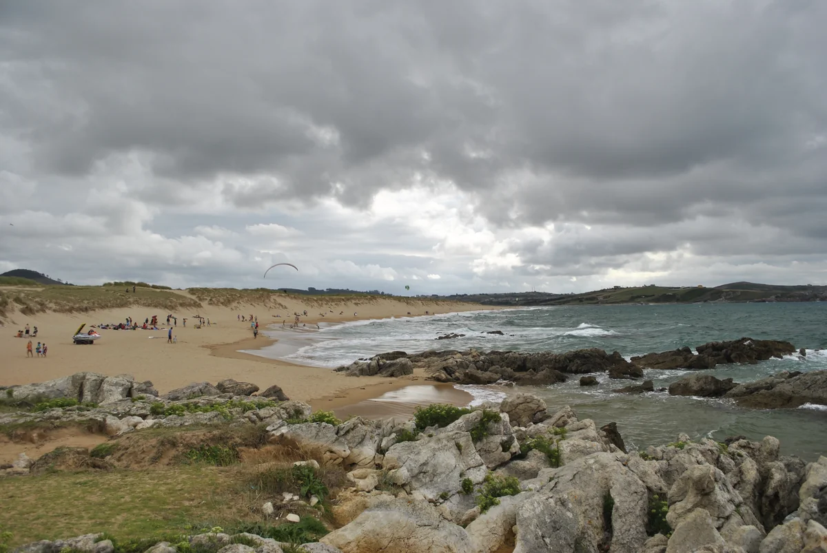
Dunes rise behind Valdearenas beach, with small distant beachgoers, breaking waves and rocks in the foreground beneath a cloudy sky.

Valdearenas beach and the Liencres dunes, photographed in July 2014.

Valdearenas y Dunas de Liencres.JPG — Malenaban / Wikimedia Commons / CC BY-SA 4.0 · Creative Commons

Walks and routes

A short visit at the beach approaches and pinewood

Use the signed visitor approaches from the Canallave–Valdearenas access area. Choose a safe stopping place to take in the coast and dune edge, then retrace your steps. If the marked pinewood paths are open and suitable, add a short out-and-back under the trees. Allow 1½–2½ hours in all. Choose your turning point to suit the group; this is a flexible visit, not a named circular trail. Do not connect the beaches by scrambling round the rocks or crossing fenced dunes.

Expect soft sand where you leave the constructed approach and uneven ground in the woodland. Before choosing a section, check its actual surface and return route. If you need a firm, step-free outing, ask the tourism office to confirm a suitable option rather than relying on the presence of a ramp.


Things to try

A small dune detective game

From the path, ask everyone to find one place where plants interrupt the bare sand and one place where wind has left a pattern. Discuss what might change after a windy day. There is no need to step onto the dunes or collect anything.

Watch the shore quietly

Bring binoculars and give resting or feeding birds plenty of room. Watch how they use different parts of the coast without following them down the beach. Plants and wildlife vary with the season, and finding a particular species is never guaranteed.

Go with a nature guide

Check Naturea’s current programme for a Liencres or coastal outing that fits your dates and group. Confirm terrain, duration, price and any accessibility needs before booking. Use the meeting point in the reservation confirmation, which may be different from the programme’s information centre.

Go with a nature guide

When the coast is too rough

If there are strong winds, thunderstorms or dangerous seas, postpone the shore walk. Use the Liencres tourism office, when open, to plan a calmer-day visit. The pinewood is not a shelter to rely on in high winds.

Wildlife and habitats

Sea bindweed

This wild plant is recorded in the young, shifting dunes. Look for it from the permitted path with a plant guide; following a patch across the sand defeats the purpose of protecting it.

European searocket

A plant of the beach vegetation, rather than the woodland. It is a useful reminder to look down at the scattered greenery as well as out to sea. Leave the whole plant, including its seed pods, where it grows.

Pines

The planted maritime pines are part of the story of attempts to hold the sand in place. Compare the tree cover with the open dunes from the path. The linked identification is at pine-genus level; it does not identify every tree to species.

Stories and discoveries

The dunes are an ongoing process

Sand delivered to the shore is moved inland by wind and trapped by plants and other obstacles. The shape you see is a moment in that process, not a finished sculpture. Keeping to the paths helps protect the living part of it.

Three names, three different scales

An old leaflet may describe only the 1986 dune park. The 2021 natural park takes in a much broader coastal landscape, while the 2025 UNESCO Global Geopark is broader again. Check which boundary a map or area figure is describing.

Getting there and practical advice

Advice before the shore

The municipal tourism office is in Liencres village at Barrio La Iglesia 14, outside this beach-access visit. Call 942 57 98 78 for access advice. For 21 September–8 December 2026, its published hours are Thursday–Sunday, 11:00–14:00 and 15:00–19:00; confirm before making a special journey.

Advice before the shore

Parking and beach services

The beach access area has parking, and Valdearenas is listed with showers. Service availability changes with the season. Bring your own drinking water and ask about toilets or any specific access need before you arrive; do not plan around summer facilities being available in October.

By road

Use the signed approach from the CA-231 towards the Liencres beaches via the CA-305. Follow the local parking layout and any capacity controls instead of seeking an overflow space on vegetation. Keep the exit and emergency access clear.

By public transport

Check the municipal bus page for your date, including the last return and whether the bus reaches the beaches or only Liencres village. The advertised S8 beach timetable was for July–August 2025, so arrange the onward journey separately unless a current beach service is confirmed.

By public transport
Sources and useful links

Wildlife you might spot

3

Each card links to a full Explore page with photos, traits, and fun facts.

Snap map for this place

Start with the big picture, then zoom in to explore individual wildlife observations around this place.

Loading map…

Good to know before you go

Follow the designated paths and beach approaches. Do not climb dune faces, cross fences or use gaps in the vegetation as shortcuts; walking on the dunes outside authorised areas is prohibited.

Check the sea forecast, tide times and local warnings. Stay away from rock edges and breaking waves, and turn back before a rising tide reduces your return space.

Both beaches have strong currents. Follow flags and lifeguard instructions when the service is operating; keep children close and make this a land-based outing when there is no supervision.

Before adding a woodland walk, ask about any remaining restrictions after the fire of 12 August 2026. Respect restoration areas and any new barriers, even if an older route description goes through them.

Bring grippy footwear, water, sun protection and a windproof or waterproof layer. Carry food you can eat without cooking, and take all litter home.

Use only the authorised parking areas and follow access staff or signs. Never park on dunes, vegetation or an emergency access; leave if the permitted spaces are full.

Look at plants without picking them, leave natural objects in place and watch birds from a distance. A photograph from the path is a better souvenir than a collected specimen.

Check current beach rules before bringing a dog, and confirm any guided activity’s pet or assistance-dog arrangements separately. Do not assume rules are the same in the pinewood and on the sand.

Frequently asked questions

No. Use the areas and paths set aside for visitors. The dune vegetation is part of the protected habitat, and the park rules prohibit crossing dunes outside authorised areas.
Plan the visit around the shore and paths. Canallave and Valdearenas are open-sea beaches with strong currents. Swimming decisions must follow the conditions, flags and lifeguard advice on the day; the 2026 lifeguard season ended on 27 September.
The recommended visit uses the public beach access areas and permitted paths. Check current access and parking arrangements with the tourism office; do not treat an old parking notice as a current tariff or guarantee of entry. Guided Naturea activities have their own reservations and prices.
Check the municipal bus information for your date and the exact stop. A direct beach service, S8, was publicised for July and August 2025; that notice does not establish an October 2026 beach bus. A service to Liencres village leaves a separate onward journey to arrange.
The names overlap, but the boundaries differ. This natural park covers parts of Piélagos, Miengo and Santa Cruz de Bezana. The UNESCO Global Geopark is a wider territory, and the old dunes-only park was smaller still.
Treat them as a separate outing with a fresh access check. Somocuevas reopened after repairs on 24 June 2026, following an earlier closure; that dated reopening is not a promise about every coastal access today. Neither beach is part of this short walk.

Recent snaps at this place

Recent snaps will appear here as new observations are added.

View all ›

Take the discovery with you

Exploring Dunas de Liencres y Costa Quebrada Natural Park?

Identify the wildlife you spot, learn as you go, and keep a collection of the adventure.

  1. 1Spot it
  2. 2Snap it
  3. 3Keep the discovery




