
Snappit logo
Snappit
Get App
Generic illustration, not a photograph of this venueIllustration
ParkTohoku, Japan

Kurikoma Quasi-National Park

The first surprise is how many different trips fit inside this one park.

About

The first surprise is how many different trips fit inside this one park. At Sekaiyachi, a woodland path brings you to open wetland and tiny seasonal flowers. Above it, Mount Kurikoma rises into a much more exposed mountain world. Farther north, Yakeishi has ponds, beech forest and alpine vegetation; to the southwest, the Kamuro range draws experienced walkers to steep approaches and narrow ridges. Naruko and Onikobe offer a lower-level journey through water-cut gorges and volcanic country, while Akita’s Oyasukyo lets you see steam escaping from the earth. Choose the landscape that suits your group, then give it a day. A two- or three-night stay can combine contrasting sectors without making every outing a race. [Official park overview](https://www.pref.miyagi.jp/soshiki/sizenhogo/sizenkouen-kurikoma.html). Turn your visit into a safari! Use the Snappit app to scan and log wildlife sightings here.

What to do here

Try a Sekaiyachi wetland walk, a Naruko viewpoint-and-forest outing, or a properly equipped Kurikoma mountain day. Treat Yakeishi and Kamuro as separate mountain plans, not extra stops after a sightseeing drive.

Seasonal info

Checked 19 October 2026: the Sukawa route carries a closure from 15 October; Kamuro’s Akita-side routes have finished for the season. Naruko–Shinjo trains remain suspended. Read the dated notices below before choosing a route.

Accessibility

A viewpoint-led visit may work better than a gorge descent or wetland boardwalk. No continuous step-free itinerary has been verified. Ask the chosen facility about the complete journey from parking to viewpoint, toilet and vehicle before setting out.

Don't miss

1

Sekaiyachi’s wetland flowers and surrounding beech woodland

2

Kurikoma’s open mountain slopes

3

Naruko Gorge and the Ofukazawa woodland loop

4

Oyasukyo’s steaming rock fissures

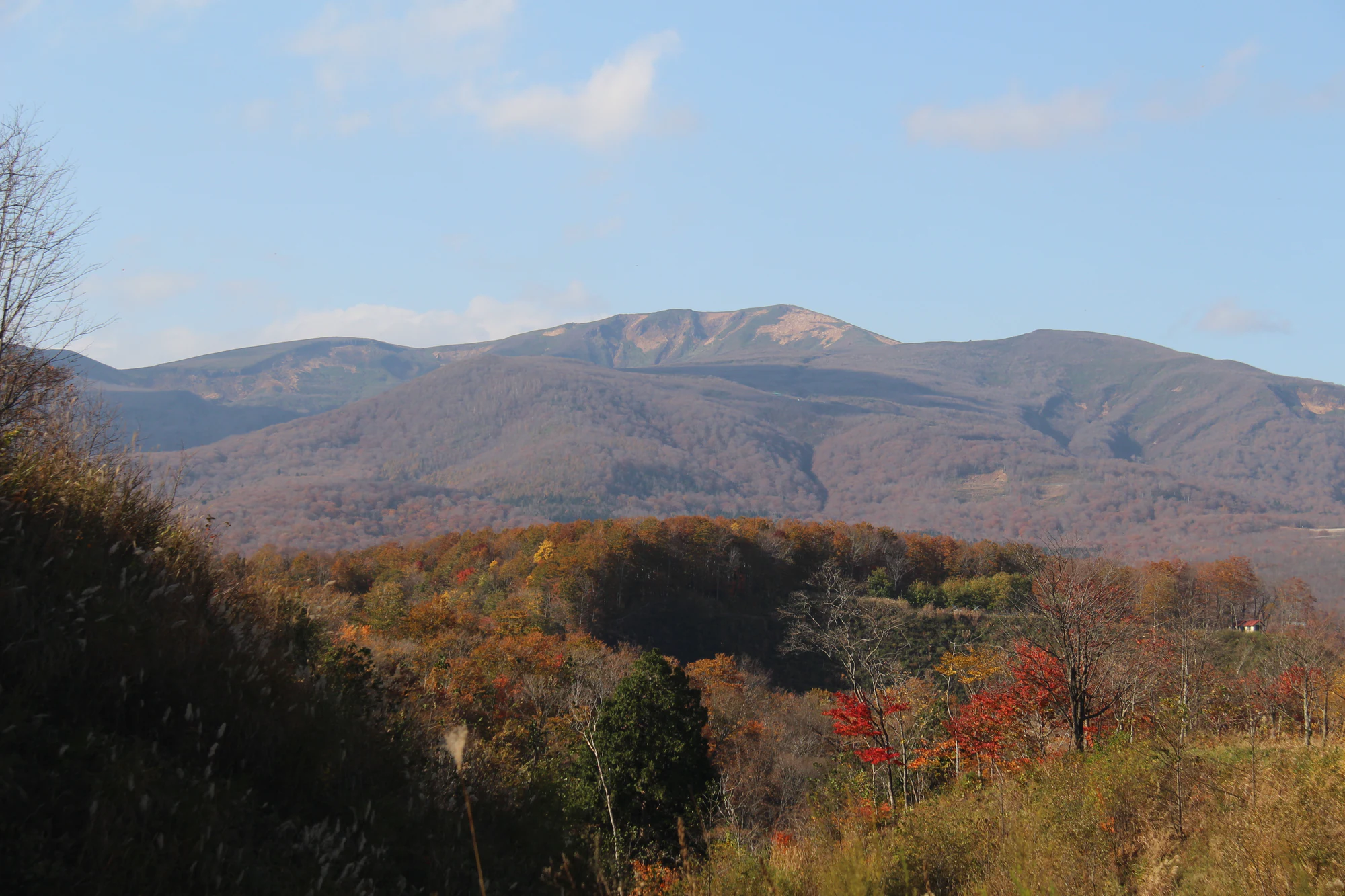
A broad mountain ridge rises above layered wooded slopes, with red, orange and green trees in the foreground under a pale blue sky; a tiny roof appears at lower right.

Mount Kurikoma above wooded slopes and autumn-coloured trees, in a photograph published by the Japan Meteorological Agency. Capture date unknown; this is not a report of current foliage, weather or access.

Source: Japan Meteorological Agency, Kurikomayama photograph 01, https://www.data.jma.go.jp/vois/data/filing/kazanbosai/volpictures.html#210. PDL1.0: https://www.digital.go.jp/resources/open_data/public_data_license_v1.0. No changes. · Creative Commons 1 · www.digital.go.jp 2

Walks and routes

A slow walk to Sekaiyachi’s first wetland

Start at the Sekaiyachi car park, use the signed entrance and follow the official path through the trees to the first wetland. Enjoy the permitted boardwalk/viewing stretch, then return by the same approach. The second wetland is an optional, longer destination only after checking the current signs; do not continue onto a closed mountain connection.

Editorial allowance: 45–75 minutes for an unhurried first-wetland visit.

Kurikoma summit by the Central Course

For equipped hikers in suitable conditions: begin at Iwakagamidaira, take the signed Central Course to the summit and return along that same route. The official map shows it separately from the Eastern Kurikoma course, which has a stream section. Do not change to a different descent simply because it appears to form a convenient loop, and do not descend into the closed Sukawa route.

Official map: about 2 hours up and 1 hour 30 minutes down, excluding rests. Editorial planning allowance: at least 4–5 hours with breaks and a firm turnaround time.

Naruko viewpoints, with an optional descent

Start at Naruko Gorge Rest House on the Nakayamadaira side. Enjoy the signed upper viewpoints first. If the gorge path is open and the group is comfortable with the climb back, descend only to Kaikobashi and return the same way. This is the western permitted section, not a through-route towards Naruko Onsen.

Editorial allowance: 30–45 minutes around the upper viewpoints, or 60–90 minutes with the descent and return.

Ofukazawa’s separate forest circuit

From the rest-house area, follow the green Ofukazawa route shown on the city map. The circuit uses the woodland path and the Ofukazawa Bridge-side connection back towards the starting area. Watch carefully at road crossings and follow current signs. Stay on this marked circuit rather than joining an unfamiliar branch of the Oku-no-Hosomichi trail.

Editorial allowance: 60–90 minutes with pauses; the city map suggests roughly 50 minutes of walking.

Things to try

A family wetland notebook

Choose one flower or leaf shape to sketch from the path, then compare it with the official plant calendar. Write down the date and weather so the notebook records your visit rather than an assumed flowering peak. Avoid picking specimens or blocking a narrow boardwalk while drawing.

A landscape comparison

At two permitted viewpoints, compare what water and volcanic heat have done to the land. Naruko shows the scale of river erosion; Oyasukyo adds steam escaping from rock. Children can describe colour, shape and sound without getting close to a cliff or vent.

A quieter birdwatching pause

Carry binoculars and give the forest a few quiet minutes from a safe spot off the walking line. The Kamuro range supports birds of prey including golden eagles. A distant silhouette is not a reliable identification on its own; enjoy the observation without approaching nests or publishing sensitive nesting locations.

Wildlife and habitats

Look first at habitat. Sekaiyachi’s wet ground supports plants such as bogbean; Yakeishi’s higher vegetation includes lingonberry. Miyagi’s park account records wild stoats and Japanese serows, while the Kamuro account records golden eagles. Their presence in the wider landscape does not promise sightings on a short visit. Photograph wildlife from a distance, keep food packed away, and let animals leave freely.

Stories and discoveries

Sekaiyachi: look closely at the wetland

The open ground is a living wetland, not a meadow to wander across. Moss and peat hold water beneath the plants, and beech woodland separates the wetland patches. In the usual flowering sequence, white mizubasho appears earlier, followed by cotton-grass, bogbean and the yellow-orange daylilies called nikko-kisuge. Later flowers keep the season interesting. Stay on the designated path and use a camera’s zoom rather than stepping off for a closer look.

Kurikoma and the Sukawa high country

The contrast between forested lower slopes and the broad upper mountain is the attraction here. Iwakagamidaira is the southern hiking base; Sukawa is a separate northern hot-spring gateway. A photograph of brilliant foliage says little about today’s wind, cloud or access. Showako is part of an active volcanic landscape, and the direct Sukawa route must not be followed while its closure applies.

Naruko and Onikobe: two different volcanic landscapes

Naruko Gorge rewards looking down from a permitted viewpoint before deciding whether to descend. Onikobe’s wider setting is a caldera landscape around Araodake, with geothermal features among the wooded hills. Its Jigokudani path is currently only partly reopened: the permitted section ends at Tochi-no-ki-yu. Keep the two places as separate stops and leave time to enjoy each rather than treating them as one walking circuit.

Oyasukyo: water, rock and steam

At Oyasukyo, the Minase River has cut a steep-sided valley through the rock. Geothermal heat warms water underground; steam and hot water escape where cracks are exposed beside the path. Kawarayu Bridge gives an upper view if the hundreds of steps down do not suit you. Listen and watch from the permitted viewing space, without touching the escaping water or reaching towards a vent.

Yakeishi: the park’s northern mountain country

Beech woodland, quiet ponds and higher alpine vegetation give Yakeishi a character of its own. The city’s Nakanuma summit itinerary is a substantial day, with about six hours of walking before extra breaks. Its sequence passes Nakanuma and Ginmeisui on the way upward. You can choose a shorter objective with suitable local advice, but a pond on a mountain trail is not automatically an easy or accessible lakeside stroll.

Kamuro: a return trip for experienced walkers

The Kamuro range brings Yamagata into the park’s story. Kamuro, Komata and Hiuchi form a ridge landscape with steep approaches, rather than a collection of roadside viewpoints. Plan conservatively, carry enough water and check the exact ascent and descent. In autumn 2026, a traverse ending on the Akita side is not possible because the affected trails are closed. Shinjo and Kaneyama are useful planning gateways.

One designation, separated landscapes

The park was designated on 22 July 1968. Its protected-area map includes a separate northern Yakeishi region as well as the broader Kurikoma region. That geography explains why “seeing the park” takes more than reaching Mount Kurikoma’s summit.

A lake made by an eruption

Showako formed following the 1944 eruption of Kurikoma. The lake’s scenic appearance does not remove the surrounding volcanic hazards. Interpret it through the official information while observing today’s access restrictions.

The forest changes with altitude

The Forestry Agency describes beech-dominated mountain forest and higher dwarf-pine/lingonberry communities around Yakeishi. Watching that change is part of the pleasure of a mountain day, even when cloud hides the distant view.

When to visit

For flowers, choose the lower wetland season and check recent local reports rather than a fixed peak date. Late spring can still mean snow on mountain trails. Summer needs an early start and a plan for rain, fog and thunderstorms. Autumn colour progresses down through different elevations as daylight shrinks and temperatures fall. Winter closes wetland and gorge paths and many mountain roads; a confirmed hot-spring stay is a different trip from a summer hiking itinerary.

Getting there and practical advice

Southern Kurikoma and Sekaiyachi

Kurihara is the practical base for the Miyagi side. The city estimates about 70 minutes by car from Kurikoma-Kogen Station to Sekaiyachi. Arrange the return taxi as well as the outward journey. The special Iwakagamidaira autumn shuttle ran only through 18 October in 2026; do not rely on it after that date.

Sukawa from Ichinoseki

Iwate Kenkotsu lists a seasonal Ichinoseki–Sukawa Onsen bus from 13 June to 31 October 2026, potentially ending earlier if Route 342 closes for winter. The advertised adult one-way fare is ¥1,550. Capacity is limited; confirm the date-specific timetable and return journey. Reaching the onsen does not mean the Sukawa summit trail is open.

Naruko and Onikobe

Naruko Onsen is the rail-side gateway from Furukawa, but the line westward to Shinjo is suspended, with replacement buses. The seasonal Koyo bus to Narukokyo Nakayamadairaguchi is scheduled for 26 October–8 November 2026, ¥450 one way from Naruko Onsen, cash payment. It is not running throughout October. Onikobe needs a separate drive, taxi or checked municipal-bus connection.

Akita and the northern mountains

For Oyasukyo, the city points to the Yuzawa–Oyasu bus from Yuzawa Station, with Kawarayu or Tokotonyama stops by the respective path approaches. Yakeishi’s eastern approaches are reached from the Oshu/Mizusawa area; the city notes partly unpaved access at Nakanuma. Kamuro uses different trailheads around the Shinjo/Kaneyama and Akita sides. Do not plan an unverified cross-mountain transfer.

A separate Kawarage stop

Kawarage Jigoku is a separately checked Akita-side companion visit. The city’s October notice allows the Doroyu approach but prohibits continuing through to Akinomiya on Route 310. Inside the geothermal area, use only the gas-avoidance detour and rope-marked path; do not enter the hot stream. Mobile reception is unreliable. Check the linked city notice again before adding it to a drive.

Oyasukyo’s gorge path has 302 steps at one entrance and 406 at the other, so its roughly 30-minute walking estimate should not be read as an easy stroll. Naruko’s gorge descent also requires a return climb. Upper viewpoints may be a better choice, but pavement, gradients, kerbs and accessible toilets still need individual confirmation. Sekaiyachi’s woodland approach and boardwalk are not certified here for wheelchairs or strollers; ask specifically about your mobility aid and the current surface.

Sekaiyachi has parking and toilets and the city lists admission as free. Naruko’s rest house offers food and a shop; its main autumn car park charges ¥500 per ordinary car during the announced 10 October–30 November 2026 period. Oyasukyo viewing is listed as free, while bathing, accommodation and transport are separate purchases. High routes have much fewer services: carry your own food, water and portable toilet, and do not depend on Showako’s toilet, which Iwate lists as unusable.

Read the latest JMA bulletin and local closures before leaving, then obey signs on the ground. Gas can be hazardous even at alert level 1; never enter a closed crater, shortcut over bare geothermal ground or linger beside a restricted vent. Wet rock, boardwalks and stairs can be slippery. Mountain weather can change quickly, so carry navigation, waterproofs and insulation, tell someone your plan and turn back early. Check bear reports, walk in company where possible, make your presence known and leave no food or rubbish. Never approach a cub or follow an animal for a photograph.

Visitor information

Sukawa: October closure overrides the July reopening

Iwate’s route page adds a closure from 15 October 2026. The earlier July reopening headline is not current permission to walk it. The same page says Showako’s toilet is unusable.

Sukawa: October closure overrides the July reopening

Kamuro: no descent to the Akita side

Both Nishinomata and Panorama routes on the Akita side are closed for the rest of the 2026 season. A route starting in Yamagata must not plan to finish there.

Kamuro: no descent to the Akita side

Onikobe: only part of Jigokudani is reopened

The city permits the section from the car park to Tochi-no-ki-yu; beyond it remains closed after heavy-rain damage. Follow the barrier rather than an older full-route description.

Onikobe: only part of Jigokudani is reopened

Gorges remain weather-dependent

Naruko’s two short gorge paths are listed for 09:00–16:00, with closure possible without notice. Oyasukyo can also close after river rises. Confirm the particular path on the day.

Gorges remain weather-dependent

Rail and mountain-road assumptions need checking

Naruko–Shinjo rail services are suspended, the 2026 Kurikoma autumn shuttle period has ended, and Route 310 does not provide a through drive from Kawarage to Akinomiya. See the gateway transport links before booking connections.

Rail and mountain-road assumptions need checking

Wildlife you might spot

4

Each card links to a full Explore page with photos, traits, and fun facts.

Snap map for this place

Start with the big picture, then zoom in to explore individual wildlife observations around this place.

Loading map…

Good to know before you go

Save your maps and return transport before leaving town.

Pack waterproofs, warm layers, drinking water and food even when the valley is sunny.

Keep every plant, stone and animal where you found it.

Choose a lower-level alternative when the summit weather is poor.

Frequently asked questions

No. This is a broad protected landscape across Iwate, Miyagi, Akita and Yamagata. Your starting point depends on the sector. Choose the gateway first, then accommodation and transport.
Sekaiyachi’s first wetland or Naruko’s upper viewpoints can make a satisfying short outing. Keep children on the path and set a turnaround time. Gorge stairs, hot ground and high mountain trails need a different level of supervision and stamina.
No. The two permitted gorge-floor sections are separate out-and-backs. The Ofukazawa circuit is a different woodland walk; it does not reopen the closed stretch of gorge.
No. Local gas restrictions, damaged paths and seasonal closures still apply. Check both JMA’s volcano information and the authority responsible for your trail.
Use an operating bathing facility with its own rules. Natural vents and streams can be dangerously hot or expose you to gas; they are not informal footbaths.
These animals belong to the wider park’s natural story, but a visit offers no guaranteed encounter. Let any animal keep its distance, and never leave the route to follow it.

Recent snaps at this place

Recent snaps will appear here as new observations are added.

View all ›

Take the discovery with you

Exploring Kurikoma Quasi-National Park?

Identify the wildlife you spot, learn as you go, and keep a collection of the adventure.

  1. 1Spot it
  2. 2Snap it
  3. 3Keep the discovery








