Snappit logo
Snappit
Get App
Generic illustration, not a photograph of this venueIllustration
ParkKR

Naejangsan National Park

For a first visit, choose a side of the park before choosing a summit.

About

For a first visit, choose a side of the park before choosing a summit. The Naejangsa valley, approached from Jeongeup, combines Uhwajeong pavilion, the maple-lined temple approach and a forest loop past small hermitages. You can enjoy the landscape without committing to the ridge above.

On the southern side, Baegyangsa sits below Baekhakbong’s pale rock face. Its temple surroundings and old nutmeg-tree woods make a satisfying visit of their own. Namchang is another gateway for Monggye Falls and Ipamsan. These entrances belong to one national park, but they are separate transport destinations. An unhurried visit to each side on different days is usually more rewarding than a rushed attempt to connect them. Wondering what that bird or insect is? Find out on your visit using the Snappit nature app.

Naejangsan became a national park on 17 November 1971. Its name is associated with the idea of treasures hidden within the mountains. The scenery has a deeper geological story too: KNPS describes predominantly Cretaceous volcanic rocks, with some older Jurassic granite. The park brings together Naejangsan, Baegamsan and Ipamsan rather than a single isolated peak. In the Naejangsa valley, the Sillok-gil story recalls the protection of the Joseon royal annals during the Japanese invasions. Around Ipamsan, fortress remains add another layer of history to the woodland walk.

What to do here

Start with a valley walk, then decide whether the group has time and energy for a longer forest route. Photograph Uhwajeong from the established viewing area, explore the open temple grounds quietly, and let the cliffs provide the backdrop. For a mountain day, select one published route and check every affected section before setting off.

Seasonal info

Spring offers fresh leaves and blossom, summer deep shade, and winter a clearer view of the rock faces through bare branches. None removes the need to check weather controls. Wet leaves, icy steps and short winter daylight can turn an apparently modest mountain into a demanding outing.

Accessibility

The inner valley and visitor centre are the better starting points for a gentler visit. The complete nature-observation loop includes steps, and summit routes involve steep stairs or rocky ground. A cable-car journey also does not establish a step-free route to the viewpoint or back to the valley.

Don't miss

1

The maple-lined approach to Naejangsa and Uhwajeong’s pond setting

2

A forest circuit linking Wonjeogam and Byeongnyeonam hermitages

3

Baegyangsa beneath the pale cliffs of Baekhakbong

4

The fortress landscape and protected wetlands around Ipamsan

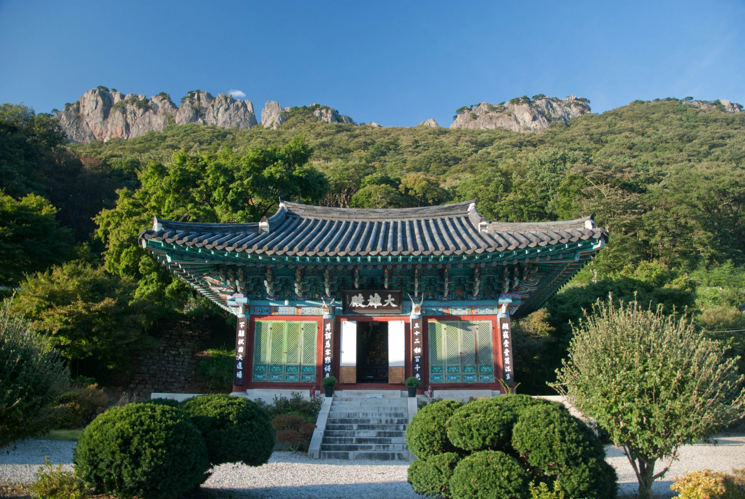
A painted traditional temple building with a grey tiled roof and stone steps stands below green woodland and a serrated pale rock ridge.

A hermitage building beneath Naejangsan’s wooded cliffs, photographed on 30 September 2011. This historical view illustrates the meeting of temple architecture and mountain scenery; it does not show current building condition or access.

“Hermitage in Naejangsan” by theaucitron, via Flickr, CC BY-SA 2.0. No changes. · Creative Commons 1 · Creative Commons 2

Walks and routes

Naejangsa nature-observation loop

Published: 3.9 km, about 1 hour 20 minutes. From the inner visitor-centre/Iljumun area, follow the signed loop through Naejangsa, Wonjeogam, Sarangui Bridge and Byeongnyeonam back to Iljumun. Allow closer to two hours if you want to linger at the hermitages and tree displays. This is the best introduction for a group that enjoys walking but does not want a summit day.

Mostly forest paths, gravel and earth, with steps toward Wonjeogam and uneven stones. The official low difficulty rating does not mean the full circuit is step-free.


Naejangsa nature-observation loop

Seoraebong and Bulchulbong circuit

Published headline: 5.9 km, about four hours. The route climbs from Iljumun past Byeongnyeonam to Seoraebong, continues toward Bulchulbong and descends by Wonjeogam. Choose it for close views of the rocky ridge and a more substantial outing above the temple valley.

Sloping paved approaches give way to steep metal stairs and mountain ground. This is a hike for people comfortable with sustained climbing.

Seoraebong and Bulchulbong circuit

Sinseonbong and Kkachibong loop

Published: 7.4 km, about five hours. Follow Geumseon Valley from the visitor-centre area toward Sinseon junction and Sinseonbong, then continue via Kkachibong and descend toward Naejangsa. Sinseonbong reaches 763 m above sea level; that is the summit elevation, not the amount of climbing.

Steep climbs, steps and rocky sections make this a full hiking commitment. Carry sufficient food and leave generous time for the descent.

Sinseonbong and Kkachibong loop

Baegyangsa ridge traverse: affected by works

Published: 8.1 km, about 5½ hours. The normal itinerary links Baegyangsa, Yaksaam, Baekhakbong and Sangwangbong, then Saja peak, Cheongnyuam and Gain village. The temple-and-cliff scenery is a major attraction, but this full route cannot be followed as described while the closure below remains in force.

Long stair climbs, steep ground and loose rock require strong legs and careful footing. The modest summit heights can be misleading.

Baegyangsa ridge traverse: affected by works

Monggye Falls to Baegyangsa

Published: 6.3 km, about 3½ hours. Start on the Namchang side near the Chonnam National University training centre, pass Monggye Falls, climb to the ridge crossroads and descend by Unmunam toward Baegyangsa. A short falls visit can turn back instead: KNPS describes about 800 m from Namchang visitor-support centre to the falls, one way.

The crossing includes a steep stone-step climb near the ridge. Even the shorter waterfall approach has uphill ground; it is not a flat riverside promenade.

Monggye Falls to Baegyangsa

Ipamsan fortress and Gatbawi circuit

Published: 10.3 km, about 4½ hours. From the Namchang approach, follow the fortress junction toward the South Gate, North Gate and Gatbawi, returning through Eunseondong Valley. The combination of old walls, forest and a rock-top outlook makes this a different experience from the Naejangsa basin.

A long walk despite generally gentler gradients, with a steeper descent from Gatbawi and stony stretches. The short barrier-free approach does not describe the whole mountain circuit.

Ipamsan fortress and Gatbawi circuit

Baegyangsa–Naejangsa crossing: affected by works

Published: 12 km, about seven hours. The normal south-to-north crossing goes via Yaksaam, Baekhakbong, Sangwangbong, Sunchangsaejae and Kkachibong before descending to Naejangsa. It is an experienced-hiker itinerary with a different finish, not a convenient transfer between temples.

A demanding mountain day with steep sections and substantial transport planning. Arrange the exit journey before starting.

Baegyangsa–Naejangsa crossing: affected by works

First visit: the Naejangsa valley

Arrive with time for the outer approach, pause at Uhwajeong, and check the day’s conditions at the visitor centre. Continue to the maple-lined temple approach. Add the 3.9 km nature loop if everyone is comfortable with its steps, then return with a margin for the bus or parking exit. Leave the summit for another visit if the valley has already filled your day.

A second day on the Baegam side

Choose Baegyangsa for a relaxed temple-and-woodland visit, or Namchang for a confirmed-open waterfall or fortress route. Do not try to fit all three into one day. While the Baekhakbong construction closure remains, the lower temple landscape is the straightforward alternative to the normal ridge traverse.

Things to try

A temple visit without a summit

On the Baegyangsa side, spend time around the open temple grounds and Ssanggyeru pavilion, with Baekhakbong’s cliff as the backdrop. This lower visit is a separate choice from the ridge route. Keep voices low near prayer halls and respect any local barriers.

The cable-car viewpoint

KNPS’s published viewpoint itinerary is 1.81 km and about 50 minutes, including a cable-car ascent and walking descent toward Naejangsa. The descent uses earth, stone and steps. Check operating conditions, fares and queues first; it is not a dependable last-minute way off a mountain, and the published time excludes waiting.

When the mountain plan changes

If the visitor centre is open and safely reachable, its exhibitions offer an indoor introduction to the park. Light rain may suit a short permitted temple-ground visit, but warnings, high water or closure barriers are a reason to postpone. A waterfall is a poor fallback when the weather has stopped a ridge hike.

Wildlife and habitats

A woodland beyond the red leaves

Japanese Maple is part of the park’s natural woodland as well as its celebrated scenery. Japanese Zelkova occurs in historical valley-forest records, while Oaks (genus) and Pines (genus) help explain the contrast between broad-leaved slopes and ridge woodland. These records describe habitats, not guaranteed sightings of particular trees on today’s walk.

Evergreens and rare summer life

Look for interpretation panels about the old nutmeg trees near Wonjeogam and Baegyangsa, and the evergreen daphniphyllum colony near the Naejang viewpoint. KNPS also highlights a brilliant jewel beetle and the yellow-flowered jin-norang-sangsahwa lily as conservation symbols. Their rarity is a reason to protect habitat, not to leave the trail searching for them. Do not collect leaves, insects or flowers.

Stories and discoveries

A single maple with a protected story

A naturally growing maple on Naejangsan was designated a Natural Monument in 2021. Its heritage interpretation emphasises the twisted branches and survival on steep ground, a reminder that the park’s appeal includes individual living trees as well as whole slopes of colour.

When to visit

Spring

Choose the temple valleys for blossom and fresh leaves. Check spring fire-prevention controls before extending uphill, and remember that thawing rock can affect the Baekhakbong ascent.

Summer

Start early for shade and carry more water than a short distance might suggest. Skip waterfalls and stream crossings during heavy rain or high water, and shorten the walk in oppressive heat.

Autumn

Give extra time to queues, approaches and the journey home. A broad foliage window is more useful than a promised peak day. Check reservations and vehicle controls separately from the mountain’s weather status.

Winter

Snow can make the forest and cliffs striking, but shaded steps may remain icy. Choose a shorter lower route unless you have winter hiking equipment and confirmed access; finish well before darkness.

Getting there and practical advice

Naejangsan visitor centre

The centre at 1207 Naejangsan-ro offers exhibitions about the park’s landscape, ecology and culture. KTO’s listing, updated 22 September 2026, gives 09:30–17:30, closed Mondays or the next weekday when Monday is a public holiday. Check before making it your main stop. Use toilets at the gateway before a long hike; mountain routes have fewer options.

For Naejangsa: approach through Jeongeup

KNPS routes rail arrivals through Jeongeup and lists city bus 171 from Jeongeup terminal toward Naejang terminal. Verify the current boarding point, destination and last return locally; the operator’s static guidance is not a live timetable. Tell a taxi driver which entrance you want rather than only naming the national park.

For Baegyangsa: plan the southern connection

KNPS lists bus access through Jangseong terminal, or rail via Baegyangsa Station and Jangseong Sageori bus terminal. Baegyangsa Station is not the temple gate. Confirm the onward service before buying a tight rail connection, and arrange a taxi if the local timetable does not fit. Namchang needs its own destination check.

Driving during foliage season

Use the designated parking for your chosen gateway and follow the current traffic notice. Parking farther out changes the walking day. Do not assume a shuttle runs, that it is free, or that a vehicle exception applies to your party without checking the current arrangements with the park.

Plan the whole access chain

KTO lists a ramped entrance, accessible toilet and wheelchair and stroller loans at the Naejang visitor centre. Ask about availability and the journey from the actual drop-off or parking space, especially during vehicle controls. The nature loop’s low grade and the cable car’s family appeal do not guarantee continuous wheelchair access. On the Namchang side, ask staff to identify the current barrier-free segment and its turnaround.

For route and access questions, call the Naejang office on 063-538-7875 or the Baegam office on 061-392-7288. Give the exact route, entrance and date you are considering.

Visitor information

Check these autumn 2026 controls first

Checked 18 October 2026. Read the KNPS control table and the latest park notices before travel. Weather, works and seasonal restrictions can change; this guide does not confirm same-day access.

Baegam construction closure

The 7 September notice closes the 0.8 km Yeongcheongul–Baekhakbong section from 10 September to 5 December 2026, subject to change. Treat it as closed unless a newer official notice confirms reopening. The normal Baegyangsa ridge traverse and Baegyangsa–Naejangsa crossing use this section.

Seorae autumn reservation

The 7 September reservation notice applies from 18 October to 16 November 2026 to the 2.8 km Seorae visitor-support centre–Seoraebong–Byeongnyeonam section, with 520 places daily. It prints October hours of 05:00–16:00 and November hours of 04:00–15:00. Confirm those published hours and your exact approach with KNPS, then book through the official reservation service. A reservation does not override a closure.

Autumn vehicle restrictions

The 8 October vehicle notice restricts Yeonjagyo–visitor centre on 24–25 October, 30 October–15 November and 21–22 November 2026, from 07:00 to 18:00. Naejangho parking–Wollyeonggyo is controlled from 30 October to 15 November when parking lot 2 fills, until 17:00. Motorcycles and bicycles are included. Dates may change; confirm any permitted disability-access vehicle exception in advance.

Sources and useful links

Wildlife you might spot

4

Each card links to a full Explore page with photos, traits, and fun facts.

Snap map for this place

Start with the big picture, then zoom in to explore individual wildlife observations around this place.

Loading map…

Good to know before you go

Keep your parking or bus approach separate from the distance of a walk that begins at the inner visitor centre.

Carry water, food, a warm layer and shoes with good grip for mountain routes.

At temple buildings, follow photography signs and leave worshippers and entrances undisturbed.

Stay on signed paths; protected woodland and wetland areas are not shortcuts.

Save your return connection before walking, especially when starting and finishing at different gateways.

Frequently asked questions

They are in the same national park, approached from different sides. Treat them as separate day plans unless you have deliberately prepared a long mountain crossing and confirmed that its entire route is open.
Use it as a prompt to check details. The control table reviewed on 18 October 2026 carried earlier reference times, and Baegam had a specific construction closure. Neither a route description nor a broad status label clears your chosen path for today.
The autumn 2026 notice applies to the named Seorae section, not a blanket booking requirement for every valley visit. Check the reservation notice if your route uses Seoraebong, including approaches from another direction.
The Korea Tourism Organization lists park admission as free. Budget separately for transport, parking and any cable-car or bookable-facility use; confirm the current charge with the operator before paying.

Recent snaps at this place

Recent snaps will appear here as new observations are added.

View all ›

Take the discovery with you

Exploring Naejangsan National Park?

Identify the wildlife you spot, learn as you go, and keep a collection of the adventure.

  1. 1Spot it
  2. 2Snap it
  3. 3Keep the discovery