Snappit logo
Snappit
Get App
Generic illustration, not a photograph of this venueIllustration
ParkHokkaido, Japan

Niseko-Shakotan-Otaru Kaigan Quasi-National Park

The name on the map covers a lot of Hokkaido: the Niseko mountains, the Raiden coast and the cliffs and headlands around Shakotan and Otaru.

About

The name on the map covers a lot of Hokkaido: the Niseko mountains, the Raiden coast and the cliffs and headlands around Shakotan and Otaru. For a first visit, choose one small piece of it. Shinsennuma, in Kyowa Town, offers a satisfying walk from sheltered woodland to an open wetland and a forest-fringed pond, without committing to a mountain summit or a day of coastal driving.

Begin at the Shinsennuma Rest House parking area on Route 66, the Niseko Panorama Line. The signed wetland entrance is across the road, so keep children close while crossing. A wooden path threads through the trees before the landscape opens out. Small pools sit among the wetland plants, and the larger pond reflects the surrounding forest when the wind drops. That transition from enclosed woodland to open sky is worth enjoying slowly.

Shinsennuma sits more than 750 metres above sea level. Its small scale is part of the appeal: you can notice a patch of flowers, watch ripples alter a reflection and still have time to look again on the way back. The main pond is roughly a kilometre from the rest house. Return along the same approach for a walk of about two kilometres, or spend a little longer on the signed wetland loop. Allow 60–90 minutes for the basic return walk with stops.

The plants give the walk a different character as the season moves on. Around late June and early July, bogbean puts white flowers along the water; July brings purple Arctic irises and yellow daylilies. Later, the wetland vegetation changes towards autumn colours. Carry the town’s flower-trail leaflet and compare shapes from the boards. There is no need to reach a particular plant or step onto the soft ground for a better photograph.

A separate, short path near the parking area leads to the Shinsennuma Observatory. On a clear day, it adds a view over Kyowa’s farmland towards the Sea of Japan and the Shakotan Peninsula. Save the actual coast for another outing. This guide stays with Shinsennuma; the longer trails towards Naganuma and the surrounding peaks need their own route, weather and bear checks. Planning to visit? Download the Snappit app to identify the wildlife you spot in real-time.

The park was designated on 24 July 1963, following earlier prefectural protection of the Niseko area. Shinsennuma’s name is associated with a 1928 visit by Toyomatsu Shimoda’s scouting party, who likened the setting to a place inhabited by gods and mountain hermits. The wooden paths protect the wetland from trampling while allowing visitors to see it at close quarters.


What to do here

Walk to Shinsennuma, pause beside the pond, then retrace the approach to the rest house. Add the signed wetland loop if everyone is comfortable on the boards. Back at the parking area, choose the short observatory walk if visibility is good. A flower leaflet and a camera are more useful here than a long checklist of destinations.

Seasonal info

Plan this as a summer or early-autumn walk. Snow commonly keeps the boardwalk out of use until around early June, and snowfall can begin by mid-October. Route 66 closes for winter. For autumn 2026, Hokkaido Chuo Bus reports closure from 23 October and has cancelled its Shinsennuma sightseeing tour for 23–25 October. Check the road information service and Kyowa’s latest notices before travelling.

Accessibility

The town warns that the wooden path has uneven sections and becomes very slippery when wet. Its flower map also marks narrow sections and a more difficult slope. Do not assume a wheelchair or stroller can complete the pond circuit. A multipurpose toilet is listed at the parking area, with seasonal opening hours. Ask Kyowa’s tourism office about the present path condition and your particular mobility needs before making the drive.

Don't miss

1

The change from shaded forest to open wetland and small pools

2

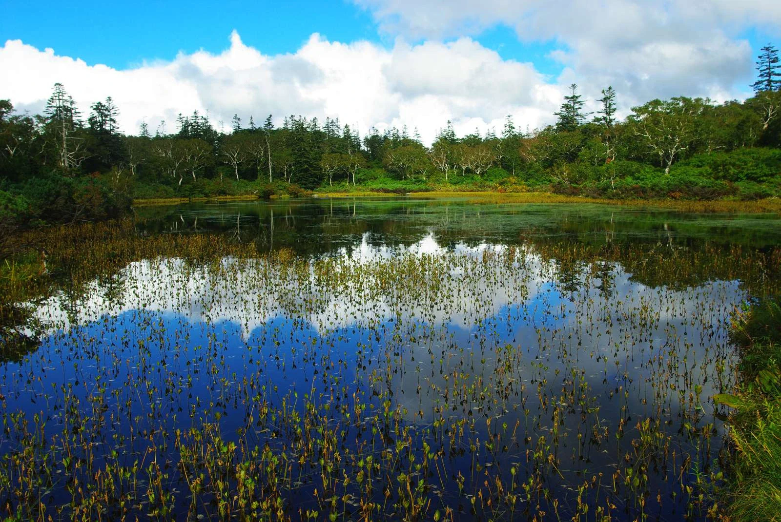
Shinsennuma’s forest reflections on a calm day

3

Bogbean flowers in early summer and a changing palette through autumn

4

A separate short lookout walk towards the Sea of Japan

Clouds and trees reflect in a still pond with wetland plants rising through the foreground water.

Shinsennuma pond and its wooded shore in September 2011, a small wetland outing within the much larger Niseko-Shakotan-Otaru Kaigan Quasi-National Park.

Shinsen Marsh, Hokkaido - Sep 24, 2011 (1).jpg — daita saru, CC BY 2.0 (https://creativecommons.org/licenses/by/2.0/). Source: https://commons.wikimedia.org/wiki/File:Shinsen_Marsh%2C_Hokkaido_-_Sep_24%2C_2011_%281%29.jpg. Resized proportionally to a maximum 2000-pixel long edge without upscaling; recompressed as WebP quality 92, method 6. No crop, retouching, added text or colour adjustment. EXIF omitted from derivative; original retained separately as evidence. · Creative Commons

Walks and routes

Rest house to Shinsennuma and back

From the rest-house parking area, cross Route 66 carefully to the signed Shinsennuma entrance. Follow the wooden path through the forest and the signs for the pond, then return by the same approach. Plan on roughly 2 kilometres there and back and 60–90 minutes with stops. Take the turn marked for Shinsennuma rather than continuing towards Naganuma.

Wooden boards have uneven places and narrow sections. Wet boards can be very slippery. Ask about current conditions before attempting this with wheels or limited balance.

Rest house to Shinsennuma and back

A little longer among the wetland pools

At the wetland, the signed wooden loop offers different views across the small pools. The town’s leaflet allows about 15 minutes of walking for the loop itself. Add this to your approach-and-return time, and allow more if you stop for photographs.

Parts of the wetland boards are too narrow for two people to pass side by side. Wait on a suitable wider section and keep both feet on the boards.

A little longer among the wetland pools

Rest house to the observatory and back

Once back at the rest house, follow the separate observatory signs. It is about 200 metres away, making a roughly 400-metre return. Allow 15–20 minutes including the view; in clear weather, look for Kyowa’s farmland, the Sea of Japan and the Shakotan Peninsula.

This is a separate wooden-path outing. Ask about slopes and access to the viewing structure before choosing it for a wheelchair or stroller.

Rest house to the observatory and back

An unhurried two-hour stop

Arrive after confirming road and trail conditions, use the seasonal toilet if open and read the entrance notices. Give the pond-and-back walk 60–90 minutes. If conditions and energy allow, choose either the wetland loop or the separate observatory, then leave time to return to your transport. Finish with a rest-house drink if it is open.

Things to try

Follow a reflection

At the pond, choose one tree reflected in the water and watch what changes as a breeze passes. Take one wider photograph and one close view without leaving the path.

A family colour hunt

Ask each person to find three different colours from a safe standing place on the boardwalk. Compare flowers, leaves and water; nobody needs to pick or touch anything.

Keep the plan flexible

In light showers, consider shortening the walk only if the boards remain safe underfoot. If rain is heavy, thunder approaches or visibility deteriorates, postpone it. When open, the rest house offers shelter and photographs of the area, but it is a small seasonal facility, so have another plan before driving into the mountains.

Wildlife and habitats

Bogbean

Around late June–early July, look from the boardwalk for white flower clusters standing above the water. These are bogbean, Menyanthes trifoliata, one of the flowers featured in the town’s trail leaflet. Photograph what is within view rather than leaning over the edge.

Round-leaved sundew

This small insect-eating plant is part of Shinsennuma’s recorded wetland flora. Its leaves trap tiny insects, which help supply nutrients. Treat spotting one as a bonus: stay on the boardwalk and leave the plant and anything caught on it untouched.

Seasonal flower colours

You can enjoy the flowers without identifying everything. Try comparing the white of bogbean, the purple of July’s Arctic iris and the yellow of the daylilies shown in the town’s leaflet. What is flowering will depend on snowmelt and the week of your visit.

Stories and discoveries

A wetland held up by peat

The Forestry Agency describes the area around Shinsennuma as a raised bog. Plant remains accumulate as peat, forming a wet surface sustained by rainwater. The boardwalk lets people cross without trampling that living surface.

When to visit

Early summer

Wait for confirmation that snow has cleared and the path is ready. Late June–early July is the town’s usual bogbean window; waterproof footwear is still useful after rain.

July and August

Look for the changing flower display and bring protection against biting insects. Keep arms and legs covered and pack a layer for cool mountain weather.

September and October

Autumn colours can begin in September, but cold and snow shorten the season. Bring warm waterproof layers and avoid leaving the visit to the last road-open weekend. For 2026, the bus operator’s notice gives 23 October as the start of the Route 66 winter closure.

Winter and spring snow

The ordinary boardwalk outing is out of season. Do not drive around a road barrier or treat snow-covered paths as an extension of the summer walk. Choose a different outing until the road and trail have reopened.

Getting there and practical advice

Parking and the starting point

Use the Shinsennuma Rest House parking area in Maeda, Kyowa Town, beside Route 66. The town lists about 80 spaces, including five for large buses; parking is listed as free. The wetland entrance is across the road.

Seasonal toilets

The parking area has toilets including a multipurpose toilet. Kyowa publishes early June–late October, 09:00–17:00. Check opening before leaving the car park; these facilities are not a dependable overnight or winter stop.

Rest house and family facilities

The rest house offers food, coffee and a shop, with a nursing room and baby-changing facilities. Published hours are 09:00–17:00, early June–late October, and lunch is 11:00–15:00. Snowmelt and snowfall can change the season. For current opening and access questions, contact Kyowa’s tourism office on 0135-67-8778.

By car

Set your destination to Shinsennuma Rest House on Route 66. Hokkaido’s tourism board gives about 35 minutes from JR Niseko Station and about 90 minutes from Otaru Interchange. Treat those as driving estimates and leave extra time for mountain-road conditions. Check Route 66 before departure.

Without a car

The former scheduled Niseko bus through Shinsennuma ended with the April 2026 timetable change. Arrange a taxi with a return pickup, or confirm that a guided tour runs on your exact date. Do not build the day around an old seasonal-bus timetable.

Choosing a manageable walk

A short distance does not remove the obstacles here: uneven boards, a slope and narrow passing space all matter. Tell the tourism office the mobility aid you use and whether steps, slippery wood or passing other walkers would be a problem. The parking-area multipurpose toilet does not establish step-free access to the pond or observatory.

Sources and useful links

Wildlife you might spot

2

Each card links to a full Explore page with photos, traits, and fun facts.

We are still adding species preview cards for this place.

Snap map for this place

Start with the big picture, then zoom in to explore individual wildlife observations around this place.

Loading map…

Good to know before you go

Check Route 66, the boardwalk and local bear notices before setting off. Follow signs and barriers even if an older leaflet shows a route.

Wear closed shoes with good grip. Bring waterproofs and a warm layer, even if the valley feels mild; postpone the walk in heavy rain, strong wind, thunder or icy conditions.

Kyowa reported bear tracks towards Naganuma on 31 July 2026 and issued advice for both Shinsennuma and Naganuma. Travel together, make your presence known with a bear bell or conversation, and turn back if you find tracks or droppings.

Carry bear spray and learn how to use it before the walk, as Hokkaido Police advises. If you see a bear, keep calm, increase your distance slowly and do not run or approach it.

Stay on the wooden paths, including while passing other visitors or taking photographs. Leave flowers, insects and other wildlife where they are, and take all food scraps and rubbish away.

Use the parking-area toilet before starting. The published opening period is early June–late October, 09:00–17:00; check the day’s opening rather than counting on it outside those hours.

The former Niseko Station–Shinsennuma–Goshiki Onsen bus was discontinued in April 2026. Arrange a car, a confirmed tour or a taxi with a return pickup before travelling.

Keep an adult beside younger children at the road crossing and on narrow boardwalk sections. Stop somewhere that leaves room for others; never use the wetland as a passing place.

Frequently asked questions

No. It is one wetland in the Niseko sector. The park also includes mountains and distant coastal areas around Raiden, Shakotan and Otaru. Mount Yōtei belongs to Shikotsu-Tōya National Park, despite its close association with Niseko.
The Forestry Agency gives about 1 kilometre from the rest house to Shinsennuma. Returning the same way makes roughly 2 kilometres. Kyowa gives 20–30 minutes each way; allow 60–90 minutes with stops. The wetland loop and the separate observatory walk add to that basic outing.
Do not assume so. Road access and a snow-free boardwalk follow different schedules. The usual walking season begins around early June. Ask about remaining snow and path repairs before making a spring visit.
There are seasonal toilets, including a multipurpose toilet, at the parking area. The rest house sells food and drinks and has a nursing room and baby-changing facilities. Kyowa lists early June–late October, 09:00–17:00, with lunch 11:00–15:00 at the rest house. Snow can change the season, so confirm opening and bring your own drinking water.
No. Niseko Town’s April 2026 service-change notice confirms the former Niseko line through Shinsennuma was discontinued. Older brochures still show it. Use a car or arrange a taxi or a currently operating tour, with the return journey settled in advance.
The Forestry Agency lists no entrance fee for the Shinsennuma district, and the tourism board lists free parking. The town’s leaflet describes a voluntary nature-conservation donation; check the sign on arrival for the current request.
It is a separate extension onto a mountain trail, rather than another section of this easy-to-follow pond return. Ask about its current condition and bear notices first, carry a suitable map and allow additional time. Keep to Shinsennuma if your group came for a short boardwalk outing.

Recent snaps at this place

Recent snaps will appear here as new observations are added.

View all ›

Take the discovery with you

Exploring Niseko-Shakotan-Otaru Kaigan Quasi-National Park?

Identify the wildlife you spot, learn as you go, and keep a collection of the adventure.

  1. 1Spot it
  2. 2Snap it
  3. 3Keep the discovery