
Snappit logo
Snappit
Get App
Generic illustration, not a photograph of this venueIllustration
ParkComunitat Valenciana, Spain

Prat de Cabanes-Torreblanca Natural Park

The Prat is a low, watery landscape between farmland and the Mediterranean.

About

The Prat is a low, watery landscape between farmland and the Mediterranean. A coastal barrier of sand and gravel helped separate an old lagoon from the sea; groundwater and seawater now influence a patchwork of reeds, sedges, salt-tolerant vegetation and open pools. Some of those pools were created by peat extraction. A stretch that looks like a uniform green marsh from a distance becomes much more varied when you stop beside a channel and look.

For a first visit, head to the southern gateway at Torre de la Sal, in the coastal part of Cabanes. The interpretation centre beside the aquaculture institute is the useful starting point, followed by the red Torre de la Sal 1 circuit. This modest loop introduces the wetland, its coastal pebble ridge and the marine-juniper micro-reserve without committing you to a long day in an exposed landscape. Check the route with staff, then let bird activity set the pace.

Torrenostra is the northern gateway, in Torreblanca municipality. It has its own interpretation facilities and yellow circuit among channels, former peat-extraction pools and the coast. It is a good alternative if you are staying there, but it is not the starting point for the short red walk. Choose one end of the park rather than trying to link them along unmarked banks or through the marsh. Unlock an interactive field guide for this spot: get the Snappit app to identify nature on the go.

The wetland formed behind a barrier built by marine sediments. Its present appearance also records human activity: drainage channels and cultivated land sit beside marsh vegetation, while peat extraction has left pools that waterbirds now use. This is a landscape shaped by both natural processes and continuing management, rather than an untouched lagoon. The Prat was declared a protected natural area by a decree dated December 1988 and became a natural park under the Valencian protected-spaces legislation in 1994. It joined the Ramsar list of internationally important wetlands in December 1989. The 2003 resource and management plan sets out how conservation, traditional uses and public visits are to coexist.

What to do here

Visit the Torre de la Sal interpretation centre if it is open, then follow the signed red circuit. Pause where the path offers a clear view of water, compare reeds with lower coastal vegetation, and watch how ducks, coots and wading birds use different edges. Use only the public viewpoints and hides that staff confirm are open.

Seasonal info

Spring is a sensitive breeding period, so enjoy birds from the path and give alarmed or displaying birds extra space. In summer, start early, keep the walk short and carry water: low elevation does not mean shelter from sun. Autumn storms can flood low ground, and winter wind can make the open coast feel much colder than nearby streets.

Accessibility

The short route is described as very easy and almost level, but that is not a wheelchair-accessibility assessment. Coastal pebbles, uneven ground and wet sections can be significant barriers. Ask the park for the currently usable accessible itinerary or viewing point, including its approach, surface, gate widths, seating and toilets, before setting out.

Don't miss

1

Torre de la Sal

a manageable southern starting point with wetland interpretation beside the aquaculture institute.

2

The red circuit

a short introduction to open water, reedbeds and the coastal landscape.

3

The marine-juniper micro-reserve

fragile coastal vegetation to appreciate from the marked route.

4

Birdwatching without rushing

coots, ducks, egrets and marsh harriers make quiet observation worthwhile.

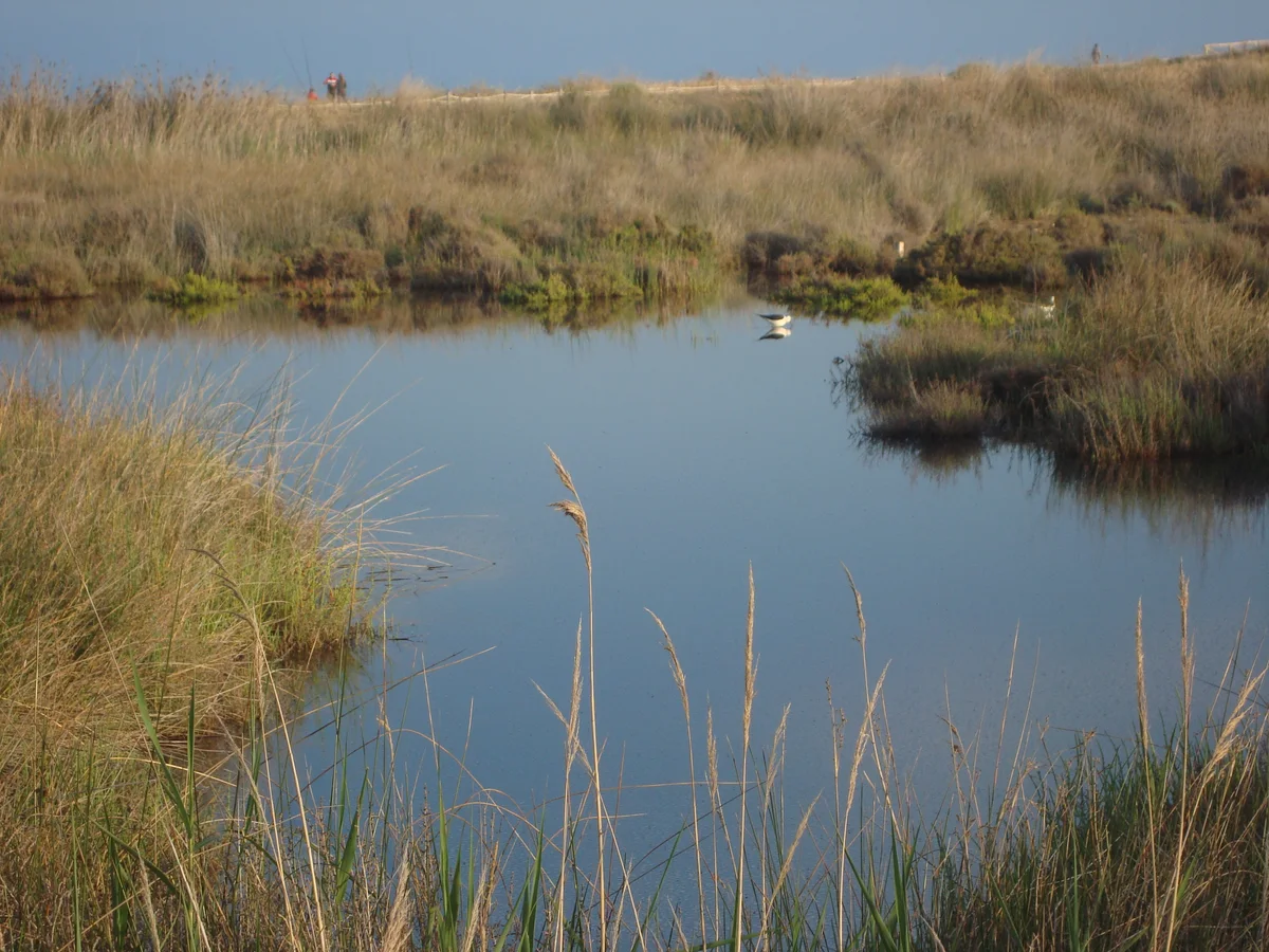
A small still pool is surrounded by reeds and low marsh vegetation, with a distant bird and the coastal ridge behind.

A reed-fringed pool in Prat de Cabanes-Torreblanca Natural Park, photographed in May 2013.

Parc Natural del Prat Cabanes-Torreblanca.jpg — Juan Emilio Prades Bel / Wikimedia Commons / CC BY-SA 4.0 · Creative Commons

Walks and routes

Red route: Torre de la Sal 1

Start and finish at the Torre de la Sal interpretation centre beside the aquaculture institute. The signed circuit combines the wetland’s birdlife and channels with views of the old coastal pebble barrier and marine-juniper micro-reserve. The latest linked municipal leaflet gives 3.37 km, about 50 minutes and very easy difficulty; think of it as roughly 3½ km and allow 90–120 minutes for observation. Check the current waymarks at the start, because older official descriptions use a shorter distance. Do not enter the plant reserve or leave the path for a closer bird photograph.

Almost level does not mean uniformly smooth. Coastal cobbles, uneven stretches, wet ground and the approach to any viewing structure need checking. Before choosing the full circuit with a wheelchair or pushchair, ask staff whether its current surface and approach suit your needs, or choose a suitable shorter alternative.

Red route: Torre de la Sal 1

Blue route: Torre de la Sal 2 / Cuartel de Carabineros

This longer circuit also starts at Torre de la Sal. It heads along the coastal side towards Torrenostra, taking in fossil dunes, the pebble barrier and the remains of the old Carabineros barracks before returning through the wetland landscape. The 2026 municipal leaflet gives 8.03 km and about two hours of walking; allow three to four hours with birdwatching and breaks. It is the longer alternative to the red loop, not an extra 8 km to add automatically to it. Follow the signed route and view the barracks remains from the signed path rather than entering the buildings.

The route is graded very easy in the leaflet, but its length, exposure and pebbly or uneven stretches make it a different commitment from the short red walk. Ask about the whole circuit’s surfaces and access before choosing it with a mobility aid. Carry water and turn back within the permitted path if conditions deteriorate.

Blue route: Torre de la Sal 2 / Cuartel de Carabineros

Yellow route: Torrenostra

Start at the southern edge of Torrenostra and follow the marked circuit towards the coastal wetland. The route introduces the Gola del Trenc, drainage channels, cultivated land and pools left by peat extraction, with a coastal pebble section. The 2026 municipal leaflet gives 4.7 km and about 70 minutes; other official descriptions round the distance to 4.5 km. Allow two to three hours to stop at permitted viewpoints. Confirm the start with the Torrenostra park centre rather than assuming the tourist-information desk is open.

The northern circuit includes low coastal and wetland ground, with pebbly sections and edges beside channels. Ask which viewpoint or shorter section is usable for your mobility needs and how to reach it without crossing rough ground.

Yellow route: Torrenostra

Two to three hours: the recommended first visit

Begin at Torre de la Sal, allowing around half an hour for interpretation if the centre is open. Follow the red circuit with two or three unhurried viewing stops, then finish at the same gateway. Keep the longer blue route for another visit; the short loop provides plenty to notice.

Half a day: a longer coastal-and-marsh circuit

Choose Torre de la Sal 2, the blue route, if everyone is comfortable with about 8 km on exposed and sometimes uneven ground. Allow three to four hours including pauses, bring enough water and check access before leaving the centre. Add time for interpretation or food outside the wetland rather than extending along unsigned tracks.

Two to three hours from Torrenostra

If you are based at the northern end, confirm the yellow route’s start and follow its roughly 4½–5 km circuit. Pause at permitted views of the channels, open pools and Gola del Trenc. Arrange your return transport before walking, particularly outside the summer bus season.

A short visit with limited walking

Call the park first and describe the distance and surface you can manage. Ask for an open centre and one currently reachable public viewpoint, with confirmed parking or drop-off and toilets if needed. Make that the whole plan rather than committing to a circuit based only on its easy grading.

Things to try

Get your bearings at Torre de la Sal

Use the interpretation centre to understand how freshwater, the sea and peat have shaped the Prat. Ask staff which route and viewpoints suit the day, then look for those habitats outside. A short conversation can be more useful than setting off with an old route screenshot.

Compare three kinds of water’s edge

From the red route, look for a reed-fringed channel, more open water and the coastal side of the wetland. Notice differences in vegetation height and bird behaviour. You do not need to reach every habitat physically to understand the contrast.

Try a patient family watch

Choose one safe stopping place and spend five quiet minutes finding something swimming, something flying and something moving in the plants. Then compare a long bill with a short one or a tall plant with a low one. Keep the challenge about noticing, not approaching wildlife.

Read the coastal ridge

Look at the pebbles and the low vegetation from the marked path. The barrier helps explain why wetland and sea sit so close together here. Do not take stones home or climb into dunes and juniper patches to improve the view.

Arrange a guided group visit

Contact the park in advance for school, association or other organised-group visits. The management plan requires an authorised guide for organised groups. Ask about group size, date, language, cost, accessible facilities and the exact meeting point rather than assuming a daily drop-in tour.

Photograph the landscape quietly

A wide view of reeds, water and the coastal sky can work even when birds are distant. Use a long lens from public ground for wildlife, keep viewing openings clear for others and avoid playback or bait. Ask the park before arranging special equipment or any activity beyond an ordinary path-based visit.

Keep interpretation as the main activity

If conditions are poor for walking, ask whether the Torre de la Sal or Torrenostra centre is open and make the displays the focus. A confirmed indoor visit can be worthwhile on its own; the temporarily closed tourist desk is not a dependable wet-weather fallback.

Shorten or postpone the outdoor part

In light rain, use only a confirmed safe, open section with suitable footwear. In thunderstorms, strong winds or flooding, postpone the wetland walk and choose activities in the surrounding towns. Hides are observation facilities, not a reason to enter the marsh during dangerous weather.

Wildlife and habitats

Eurasian coot

A dark waterbird with a white bill and forehead shield is a useful starting point for beginners. Watch one swimming across an open pool, diving or picking at vegetation. Compare its rounded shape and movements with nearby ducks.

Little egret

Look for a slender white heron with a dark bill and dark legs; the yellow feet may be hidden by water or mud. Watch it taking deliberate steps through the shallows. Stay on the path even when a bird appears close to a channel edge.

Red-crested pochard

A well-marked male has a rounded orange-brown head, red bill and striking contrast between dark breast and pale sides. Females are quieter in colour, with a paler cheek. Scan open water slowly rather than expecting every duck to show its best identification features.

Western marsh harrier

Look above the reeds for a broad-winged bird of prey quartering low over the marsh. Females and juveniles can look dark with a paler crown, while adult males have a more mixed pattern. Enjoy the hunting flight without trying to follow the bird to a nest or resting place.

Black-winged stilt

Very long pink-red legs, a thin straight bill and a black-and-white body make this wader distinctive. Watch from a permitted viewpoint as it picks small food items from shallow water. If birds become agitated, move away rather than investigating why.

Common reed

Reedbeds are part of the habitat, not just a screen hiding the water. Notice the upright stems and feathery flowering heads, and listen for movement within them. Compare the tall stands with the lower vegetation towards the coast without stepping off the path.

Great fen-sedge

This sedge is one of the important plants in the park’s wetland communities. Ask at the centre how to recognise it among the reed and sedge vegetation; a distant green stand is not enough for a confident identification. Leave plants untouched and use interpretation signs to connect their names with their habitats.

Wildlife varies with season, water levels and disturbance. Watch quietly from authorised paths and hides, leave plants and stones where they are, and never feed birds or use recorded calls to draw them out. Give breeding and resting birds space; if your presence changes their behaviour, move back. No particular sighting is guaranteed.

Stories and discoveries

Fresh and salty water meet in the same wetland

Groundwater inputs and marine influence create differences in salinity across the Prat. Those differences help explain why dense reeds, sedge communities and salt-tolerant plants occur close together.

Open pools can have an industrial history

Peat extraction has created some of the park’s open-water areas. The Torrenostra circuit is a useful place to understand this relationship between worked ground, channels and habitat. Treat extraction or service areas as working or restricted land, regardless of how inviting a track looks.

Small plants receive their own protection

The coastal marine-juniper micro-reserve protects a different community from the tall marsh vegetation. Staying on the marked route protects both the plants you can see and the smaller ones that are easy to overlook.

One park, two practical gateways

Torre de la Sal and Torrenostra serve different ends of the same wetland. The first is the natural base for the red and blue circuits; the second serves the yellow circuit. Choosing a gateway makes the visit more manageable without reducing the park to only one municipality.

When to visit

Spring

Give breeding birds space and use the public paths without lingering where birds show alarm. Mild mornings can be rewarding for listening and observing activity around reeds, but avoid turning a sighting into a search for a nest.

Summer

Start early, carry more water than the distance alone suggests and shorten the outing in heat or wind. Recheck park restrictions before travelling. The longer blue route is an exposed half-day commitment, not simply a flat extension to add at noon.

Autumn

Migration adds variety, while the first heavy rains can quickly change low-lying paths. Check the forecast and use the shorter red route if the weather window is limited. Northern bus services have a separate autumn timetable.

Winter

Wintering waterbirds make slow scans of open water worthwhile. Bring a windproof layer and allow for the difference between a sheltered street and the open coastal marsh. Confirm seasonal services and centre opening before making them essential to the day.

Getting there and practical advice

Torre de la Sal interpretation centre

The southern visitor base is in Ribera de Cabanes, beside the Instituto de Acuicultura de Torre de la Sal. The official park contact is +34 964 376 410 and [email protected]; regional tourism also lists +34 679 196 327. Confirm exhibition opening, current route advice and any group arrangements before travelling.

Torrenostra park interpretation centre

The Generalitat directory places the northern centre at Avenida Castellón 34, Torrenostra, with +34 636 502 585 and [email protected]. Ask specifically about the park centre and the yellow route when calling; the separate tourist-information desk has its own schedule.

Espai Natura tourist-information desk

Tourist Info Torreblanca Playa is listed at the Espai Natura building on Avenida Castellón. At the 17 October 2026 check it was marked temporarily closed, with selected exceptional openings. For tourist-office information, the published number is +34 678 702 188 and email [email protected]. Confirm the next opening rather than relying on a morning-hours listing elsewhere.

Hides and viewpoints

Use public observation facilities and marked viewpoints along the authorised routes. The Gola del Trenc viewpoint is described for the northern circuit. Ask which hides are open and reachable today; do not assume every structure shown in an older guide is unlocked, in good condition or wheelchair accessible.

Toilets, water, food and seating

Check the exact centre’s toilets and opening before departure, including accessible provision if required. Bring drinking water and any food you need, and plan to use services in the surrounding settlements. A short, easy-rated route does not guarantee a tap, café, bench or toilet along the way.

By car or taxi to the red route

Ask for the Torre de la Sal interpretation centre beside the aquaculture institute, in coastal Ribera de Cabanes. The inland town of Cabanes and the northern Torrenostra centre are different destinations. Follow local signs and use authorised parking or drop-off areas; keep gates and working access clear. Do not drive along the coastal Colada del Mar or a park track simply because a navigation app suggests it.

Public transport to the northern gateway

Torreblanca publishes a seasonal bus between the town and Torrenostra, including a railway-station stop. Its autumn 2026–2027 notice was followed by a 14 September notice cancelling two Calle San Antonio stops. Check current operating days, boarding point and the return before travelling. This service reaches the Torrenostra end; it does not establish a direct bus to the Torre de la Sal red-route start.

Make the last mile part of the plan

If arriving without a car, confirm the current connection to your chosen gateway and any walking approach with the park or municipality. Arrange a taxi where necessary and verify the pickup point for the return. Avoid improvising a roadside walk or treating a track across the marsh as a link between centres.

Cycling

The management plan limits cycles to suitable permitted paths and excludes cross-country vehicle movement. Ask staff which current route can be cycled, respect pedestrian signs and dismount around viewing stops where needed. Do not infer cycle access from a walking trail’s low difficulty.

Choose the exact experience

Ask for an accessible itinerary or viewing point that is open now, rather than asking whether the whole park is accessible. Explain your wheelchair, mobility aid, pushchair or walking-distance needs and whether you can manage loose stones or uneven ground. The red route’s easy grade measures walking difficulty, not access for every visitor.

Check the complete approach

Confirm where you can park or be dropped off, how far the entrance and viewing point are, and whether there are steps, gates, narrow sections or soft ground. Ask separately about toilets, seats and viewing-window height. Get details for the exact route and facility you intend to use.

Recheck after rain or strong coastal weather

A route that is manageable in dry conditions may be less suitable after flooding or damage. Let staff suggest a shorter option and keep the centre visit as a fallback if it is open. Do not work around a barrier or flooded section through vegetation.

Assistance dogs

Pet restrictions apply in the ecological-protection zone. If you use an assistance dog, discuss the recognised access arrangements and your proposed route directly with the park before travelling.

Opening hours

The Generalitat directories list general public-service hours of 09:00–14:00, Monday to Sunday, for the park and its Torrenostra interpretation unit. Telephone to confirm the centre you want, especially on holidays or if your visit depends on indoor displays, toilets or staff assistance. The paths, centres, tourist-information desk and hides should not be assumed to share a single timetable.

Independent visits, groups and prices

Independent walking on authorised paths is permitted under the management plan, subject to temporary limitations. Organised groups require an authorised guide. Confirm current admission arrangements, tour prices and booking availability directly with the park before making plans.

Pets, collecting and camping

Pets are excluded from the ecological-protection zone, including animals on a lead. Leave plants, animals, stones and minerals in place. Fires and wild camping are prohibited, and visitors must respect staff instructions, marked routes and restricted areas.

Weather and temporary restrictions

Check the park’s current notices and 112 Comunitat Valenciana weather information before leaving. Strong wind, storms, flooding, fire-risk restrictions or conservation work may change the visit. If a path is closed or under water, choose another authorised option or postpone; a published route is not permission to cross a barrier.

Sources and useful links

Wildlife you might spot

7

Each card links to a full Explore page with photos, traits, and fun facts.

We are still adding species preview cards for this place.

Snap map for this place

Start with the big picture, then zoom in to explore individual wildlife observations around this place.

Loading map…

Good to know before you go

Check the park’s latest notices and telephone before travelling if you need the centre, a hide or a particular accessible route. Follow any temporary closures on arrival.

Navigate to the Torre de la Sal interpretation centre beside the aquaculture institute for the red walk, rather than to inland Cabanes or the Torrenostra centre.

Carry binoculars, drinking water, sun protection and a windproof layer. Choose supportive footwear for uneven and pebbly sections.

Follow the signed circuit and keep off dunes, marsh vegetation, channel banks and private or working tracks. Never detour around a flooded section through habitat.

Leave pet dogs out of the wetland visit

the ecological-protection zone excludes pets even on a lead. Discuss assistance-dog arrangements with the park in advance.

Keep children close beside channels and pools. Stop on firm public ground to watch birds rather than moving down to the water.

Organised groups should arrange an authorised guide through the park. Confirm any activity’s booking, price, language and meeting point.

Plan food, drinking water and toilets before the walk; do not rely on services along the trail. Take all litter home and do not light fires.

Frequently asked questions

For the recommended short visit, use the Torre de la Sal interpretation centre beside the aquaculture institute in Ribera de Cabanes. Torrenostra is a separate northern gateway with its own yellow route. Check the centre name as well as the park name when arranging transport.
The management plan permits independent visits on authorised paths, subject to temporary restrictions. Stay on the signed public routes and follow instructions from park staff. Organised groups must use an authorised guide; ask the park about arrangements before booking a group outing.
Plan for about 3½ km. The linked 2026 municipal leaflet gives 3.37 km, while another official tourism page rounds it to 3.5 km and an older municipal web description still says 2.5 km. Confirm the signed circuit at the centre and allow 90 minutes to two hours with stops.
Confirm the current centre and walk admission arrangements with the park when checking opening. Guided activities may have separate prices and reservation requirements.
Call to confirm the particular centre and date. The official directory gives general morning service hours, but this does not guarantee every exhibition or hide is open. As checked on 17 October 2026, the separate Torreblanca Playa tourist-information desk inside Espai Natura was listed as temporarily closed, with selected exceptional openings.
Discuss your needs with staff before choosing a route. Ask staff whether the full circuit’s current surface suits your wheels, or choose a shorter accessible option. Confirm the approach from your arrival point, surface condition, turning space and accessible toilets.
Pet animals are excluded from the ecological-protection zone, even on a lead. Plan the wetland walk without a pet dog. Contact the park beforehand about assistance dogs and any particular access needs.
Stay on the authorised route and respect barriers. Dunes, plant micro-reserves, water margins and extraction areas are protected or potentially unsafe ground. The guide’s coastal sections are for viewing the landscape from public paths, not an invitation to cross habitat or enter the water.
Use binoculars or a telescope and give them time. The shape of a bill, feeding behaviour or a marsh harrier’s flight can be interesting at a distance. Wildlife changes with season and conditions, so enjoy the plants, water and coastal ridge too.

Recent snaps at this place

Recent snaps will appear here as new observations are added.

View all ›

Take the discovery with you

Exploring Prat de Cabanes-Torreblanca Natural Park?

Identify the wildlife you spot, learn as you go, and keep a collection of the adventure.

  1. 1Spot it
  2. 2Snap it
  3. 3Keep the discovery
