
Snappit logo
Snappit
Get App
Generic illustration, not a photograph of this venueIllustration
ParkAndalucía, Spain

El Torcal de Antequera Natural Area

El Torcal is a place to slow down and look carefully.

About

El Torcal is a place to slow down and look carefully. A stack of limestone can resemble a face from one angle and a pile of plates from another; a shaded crack can hold a surprising pocket of green. Start at Torcal Alto visitor centre and choose one marked walk. For most first visits, the short Ruta Verde gives you plenty to notice without turning the day into a long mountain hike.

These rocks began as marine sediments more than 150 million years ago. Uplift, fractures and the long work of water have shaped the limestone into the landscape you see today. The shallow hollows known as torcas give the place its name. The centre helps connect those big geological processes with small things you can recognise outside, from bedding layers to plants rooted in fissures.

The setting feels far removed from the coast, and the weather can be very different too. Torcal Alto lies around 1,200 metres above sea level. Its short trails still have rough footing, while mist can hide the way ahead. A centre-and-viewpoint visit is worthwhile on its own; choose a trail only when the conditions and everyone’s balance and stamina suit it. Enhance your adventure: download the Snappit app to identify the local species you encounter.

El Torcal received national protection in 1929 and its present Andalusian category, Paraje Natural, in 1989. Its landscape also holds a human story of grazing, charcoal-making and quarrying, as well as prehistoric cave occupation. Since 2016, El Torcal has formed part of the serial UNESCO Antequera Dolmens Site alongside the megalithic monuments and La Peña de los Enamorados. The connection is cultural as well as scenic: the Tholos of El Romeral is oriented towards El Torcal. The dolmens are a separate stop, not something reached on these walking loops.

What to do here

Begin with the exhibits, then follow Ruta Verde at an unhurried pace. Add Las Ventanillas viewpoint if the weather is clear. Confident walkers wanting more time among the rocks can choose Ruta Amarilla instead; the two loops share sections, so there is little reason to complete both on a first visit.

Seasonal info

Rain and mist can make the limestone extremely slippery and the route hard to follow in any season. Strong wind, winter ice or snow and summer heat may justify a shorter visit or postponement. Check access arrangements again for busy holidays and evening events.

Accessibility

The visitor centre is described by the Junta as adapted for physical and sensory access needs, and Las Ventanillas has a physical-accessibility symbol. Ask staff about the current approach, toilet and support you need. The green, yellow and uphill trails are uneven, rocky walking routes, unsuitable for ordinary wheelchairs or pushchairs.

Don't miss

1

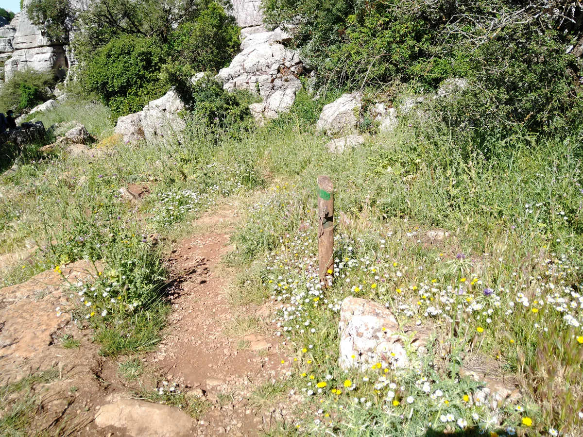
Layered limestone and narrow passages on the marked Ruta Verde

2

The view towards Villanueva de la Concepción from Las Ventanillas

3

Torcal Alto’s explanation of the ancient sea, wildlife and human history

4

Small patches of vegetation growing among seemingly bare rocks

A narrow stony path curves through grasses and small flowers beside limestone outcrops, with a wooden green route marker in the foreground.

Limestone formations beside El Torcal’s Green Route, photographed in June 2021.

Sendero verde del Torcal 20210608 08.jpg — Ismael Olea / Wikimedia Commons / CC BY 4.0 International · Creative Commons 1 · Creative Commons 2

Walks and routes

Ruta Verde: the first-visit loop

Begin at the upper car park. The green markers guide you between limestone formations and return you to the visitor-centre area. Much of the route is shared with the yellow loop: follow your chosen colour at the split rather than simply following the people ahead.

Natural, irregular limestone tread; wet surfaces can be very slippery. This is not a wheelchair or pushchair route, and some walkers using sticks will find the footing demanding.


Ruta Verde: the first-visit loop

Ruta Amarilla: a longer look at the karst

This extends the green-loop experience through more passages, hollows and shaded vegetation before returning to Torcal Alto. Choose it while you still have time, energy and clear conditions; the extra distance means more time on awkward surfaces.

Rough natural ground with stones, uneven tread and damp shaded sections. Not suitable for ordinary wheelchairs or pushchairs; balance and secure footwear matter more than the modest kilometre total.

Ruta Amarilla: a longer look at the karst

Subida al Torcal Alto: the orange-marked approach

This signed path links the lower parking area to Torcal Alto, passing evidence of former quarrying and pastoral use and the El Tornillo formation. It is a walk in its own right. Do not start it as an improvised substitute for a short shuttle ride; arrange your return and allow for daylight.

A substantial ascent over stony, uneven ground. Unsuitable for ordinary wheelchairs or pushchairs and a poor choice for anyone already struggling with the shorter loops. If the road is closed, ask whether the trail itself is open.

Subida al Torcal Alto: the orange-marked approach

A relaxed first morning

Start with the centre and an honest check of everyone’s footwear and confidence. Walk Ruta Verde slowly, then decide whether there is enough energy and clear weather for Las Ventanillas. Aim for 2–3 hours on site, and leave room for waiting if the shuttle is operating.

The shorter, lower-effort visit

Make the centre your main stop. Ask staff about reaching Las Ventanillas using the most suitable nearby approach, and choose a brief outdoor pause if conditions suit. Allow roughly 45–90 minutes, without committing to either rocky loop.

A half-day with the yellow loop

Choose Ruta Amarilla instead of the green and give its two-hour walking estimate room for stops. Return to the centre for a rest or a separately confirmed meal. If you arrived by shuttle, check the final descent before you set out rather than discovering the timetable after the walk.

Things to try

Learn to read the rock

Look for horizontal layers and the gaps that water has widened, then compare them with the centre’s explanation of the ancient sea. Keep a small sketchbook or make a photo pair of one rock from two safe positions on the path. The point is to notice a process, not to reach every named formation.

A gentle rock-shape game

Invite children to describe an animal, face or everyday object they can see in the limestone. Different answers are part of the fun. Set a simple rule: observations happen with feet on the path and everyone within sight, so imaginative play does not become climbing or hide-and-seek among fissures.

Notice the small green spaces

Compare vegetation in a shaded passage with the plants on a sunnier stretch. Roots find footholds in cracks, and different pockets retain different amounts of moisture. Leave flowers untouched and avoid pressing into the vegetation for a closer photograph.

Book more interpretation if you want it

Ask the centre about current guided geology or family activities, their minimum ages, terrain and language. Some offered walks use unmarked terrain with a professional guide; their names are not instructions for independent exploration. Confirm the actual activity before paying or travelling.

Astronomy on a separate booking

An observatory beside the centre offers astronomy activities. Check its current programme, weather arrangements, access and return transport; an evening event is a separate plan from a daytime walk. Bring warm clothing and avoid wandering into the karst after dark.

Use the exhibition if travel is safe

If the road is open and it is safe to get there, the visitor centre can carry the visit without a loop. Confirm opening first. A café break does not make wet limestone less slippery, so let the walk wait if the weather stays poor.

Keep another day available

Dense mist and severe wind are good reasons to choose a different day. Stay off unfamiliar tracks and out of caves as shelter. If you are already on a marked route, keep together and seek staff or emergency assistance rather than wandering in search of a shortcut. Call 112 for an emergency.

Wildlife and habitats

Iberian ibex · Capra pyrenaica

Scan the rocky landscape from a safe place on the path. If an ibex is nearby, pause and let it choose its distance; never follow it onto ledges or offer food.

Griffon vulture · Gyps fulvus

Stop walking before looking skyward. Binoculars can turn a distant soaring bird into a rewarding observation without leaving the public route.

Peregrine falcon · Falco peregrinus

Watch birds in flight with binoculars from a steady position, then compare what you have seen with the centre’s interpretation. Keep well away from cliff nesting areas and avoid using recorded calls.

Red fox · Vulpes vulpes

If a fox crosses your view, stand quietly and leave it a clear way through. Food scraps should leave with you rather than encouraging animals towards visitors.

Montpellier maple and rock-crevice plants

Ask staff about the Montpellier maple associated with the marked loops, then look for contrasts between shaded greenery and exposed limestone. Ivy is another conspicuous part of the vegetation. Photograph plants from the path rather than searching into fragile crevices.

Stories and discoveries

The hollows name the landscape

Torcas, also called dolinas, are closed depressions in the limestone landscape. The reddish material in their bottoms includes residues left as carbonate rock dissolves. Look from the route rather than stepping into a hollow to inspect it.

Much of the water travels out of sight

Fractured limestone allows rain to enter an underground aquifer. That helps explain why a rocky upland can feed springs below. A damp patch or clear spring is not an invitation to drink untreated water.

El Tornillo is protected within the protected area

The screw-like El Tornillo formation has its own Monumento Natural designation inside the larger Paraje Natural. The orange-marked approach passes this distinctive stack; enjoy it from the path and leave the rock untouched.

The mountain belongs to a cultural story too

UNESCO’s Antequera Dolmens Site links prehistoric monuments with the prominent natural landforms around them. El Romeral’s orientation towards El Torcal is part of that relationship. Visit the monuments separately if you want to follow the story into the city’s archaeological heritage.

When to visit

Spring: take time over the vegetation

A settled spring day suits slow walking and noticing the plant life between rocks. Keep a windproof layer even when the lower towns feel warm, and check the forecast before committing to the longer loop.

Summer: keep the walk manageable

Choose cooler hours, carry ample water and use sun protection. Shade in a passage is a welcome pause, not a guarantee of a cool route. Arrange any evening programme separately and check the access rules that apply to that event.

Autumn: good walking weather can be busy

Mild, clear days can draw many visitors, so allow for parking controls. After rain, damp limestone and shaded ground deserve particular care. Choose the shorter loop if uncertain how the group will manage.

Winter: conditions come first

Cold, mist, wind, ice or snow can change a familiar-looking short walk. Do not assume conditions resemble Málaga or Antequera below. When the road or terrain is unsafe, postpone rather than trying an unofficial alternative.

Getting there and practical advice

Torcal Alto visitor centre

At the end of the access road, km 3.5. Admission is free. The visitor website lists daily hours of 10:00–19:00 from April to October and 10:00–17:00 from November to March, closing on 25 December and 1 and 6 January. Reconfirm the timetable directly following the September 2026 management change: +34 683 146 594 or [email protected].

Las Ventanillas viewpoint

Near the centre, this is the natural stop for views over Villanueva de la Concepción and the Río Campanillas valley. Ask about the approach if you use a wheelchair or walking aid. In mist there may be little to see, and a windy viewing stop can be uncomfortable even when the exhibition is sheltered.

Toilets, food and a rest

The centre complex lists toilets, a shop and a café-restaurant. Check restaurant service separately if lunch is important to your plan. Bring your own drinking water and a snack rather than relying on a particular outlet being open when you return.

Make time for the indoor displays

The exhibition connects geology, wildlife and past uses of the mountain. The Junta also describes an audiovisual with Spanish or English subtitles. Ask which interpretation resources are operating and which suit your language or sensory needs.

Arriving by road or without a car

Use the signed turn from the A-7075 near km 42 between Antequera and Villanueva de la Concepción. Follow the main signed approach rather than an apparent shortcut suggested by a navigation app. Without a car, arrange a return taxi or a booked excursion with transport; reconfirm availability and pickup before the outing.

When parking fills

The upper road is restricted when the centre’s parking reaches capacity, especially on busy weekends and holidays. Follow staff to the lower car park; that can also fill. Vehicles displaying a disability-parking card are listed as exempt from ordinary capacity restrictions, but confirm your arrangements and obey any safety closure.

Plan both shuttle journeys

At the 17 October 2026 check, the dedicated access page quoted €3 per person for a return or a single leg. Older pages still show €2, so reconfirm the fare. Frequency varies, and a single-bus service has a roughly hour-long driver break. Check the posted break and last descent on arrival; the published service ends around 17:00–17:30, but do not leave your return to the last bus.

Travelling with a dog

Dog carriage on the shuttle is restricted, with specific arrangements for accredited assistance dogs. Ask in advance about your animal and the vehicle; do not depend on a driver making an exception. Plan an allowed car arrival or another day if the transport cannot accommodate you.

Walking up is a different outing

The orange-marked trail from lower parking is almost 3.8 km each way over rough ground. It adds a substantial walk before you reach the short loops. If a long walk was not your plan, wait for suitable transport or change the visit rather than following the road on foot.

Start with the centre and your specific needs

The Junta describes the building as adapted for physical and sensory access needs, including an information area for wheelchair users. Ask about parking-to-door access, the accessible toilet, available interpretation and any temporary changes. Reserved parking does not remove the need to check the whole approach.

Check the short viewpoint approach

Las Ventanillas carries the Junta’s physical-accessibility symbol. Ask staff about current surface, gradient, distance and assistance for your particular wheelchair or walking aid. That symbol does not extend to the neighbouring green and yellow trails.

Be realistic about uneven footing

On the marked loops, frequent stones, awkward tread and slippery patches can be tiring for someone with limited balance or stamina. The green route is shorter, not an accessible path. A centre visit plus a comfortable outdoor stop may be the better day.

Confirm vehicle access before relying on it

The dedicated access page allows vehicles with a displayed disability-parking card through ordinary capacity controls. It does not establish wheelchair boarding provision on every shuttle. Arrange the transport and access you need directly with the centre.

Visitor information

Reconfirm practical details this season

The visitor centre changed management in September 2026, and further improvements were announced. Before travel, use the Junta-listed centre contact to check opening, guided activities, parking and the current shuttle arrangements. Treat advertised future improvements as plans until staff confirm they are operating.

Ask about the approach road

The Junta still links a damaged-surface advisory dated 28 August 2024. Antequera announced resurfacing work starting on 23 September 2026. Ask the centre whether any work or restrictions affect your date, drive to the conditions and follow local signs. These notices alone do not tell you that the whole area is closed.

2026-10-17

Sources and useful links

Wildlife you might spot

4

Each card links to a full Explore page with photos, traits, and fun facts.

Snap map for this place

Start with the big picture, then zoom in to explore individual wildlife observations around this place.

Loading map…

Good to know before you go

Check the forecast, road notices and the centre’s opening before setting out. Ask specifically whether recent roadworks or access changes affect your visit.

Wear grippy walking shoes or boots and bring water, a snack, sun protection and a warm windproof layer. Treat even the shortest loop as a mountain path.

Follow the colour markers and keep your group together. Avoid shortcuts, rock climbing for a photograph, cave entrances and deep fissures; turn back if conditions deteriorate.

Choose your trail before the junction. The yellow loop is a longer alternative to the green, while the orange route is the substantial climb from the lower parking area.

Leave extra time for busy-day parking and transport. Do not wait beside the access barrier or block the road needed by emergency vehicles.

Photograph fossils and plants where they are. Leave rocks, flowers and even attractive fallen material in place, and carry out all litter.

Keep dogs on a lead and confirm transport arrangements before arriving with one. Pet access to the shuttle is restricted.

Watch wildlife quietly from the marked path and give animals room to move away. Do not feed or follow them, approach nests or expect a sighting on every visit.

Frequently asked questions

Start with Ruta Verde if everyone is comfortable on stony ground. It is the shorter loop, with a stated walking time of 45 minutes; allow longer for children and stops. For limited mobility, begin with the centre and ask about Las Ventanillas instead.
The marked public trails are advertised as free, without advance booking or a permit for an ordinary self-guided walk. Respect temporary closures. Organised guided activities have their own bookings and conditions.
No. Short does not mean smooth: the natural tread is rocky and irregular. Ask the centre which nearby accessible paths suit your pushchair or mobility aid.
Follow the access staff’s directions to the lower parking area. The shuttle and the uphill walking route are different commitments; read Getting there and getting back before deciding to walk.
No. Fossils, minerals and plants must stay in the protected area. Use the exhibits or a booked interpretation activity to learn more, and take photographs without scraping or marking the rock.
Stay on the marked public paths for this visit. The karst contains shafts and confusing passages. Caving needs separate authorization and specialist preparation; a visible cave opening is not a visitor attraction.
Camping and fires are prohibited. Parking caravans, motorhomes and similar vehicles overnight between sunset and sunrise is also prohibited within the natural area. Arrange accommodation or an authorised overnight location elsewhere.
Plan a return taxi or a booked excursion with transport. The visitor website does not advertise a regular public bus to the centre; the busy-day shuttle starts at the lower car park, not in Antequera.
Its official category is Paraje Natural, an Andalusian protected natural area. The visitor centre, marked trails and El Tornillo natural monument all sit within that one area.

Recent snaps at this place

Recent snaps will appear here as new observations are added.

View all ›

Take the discovery with you

Exploring El Torcal de Antequera Natural Area?

Identify the wildlife you spot, learn as you go, and keep a collection of the adventure.

  1. 1Spot it
  2. 2Snap it
  3. 3Keep the discovery







