
Snappit logo
Snappit
Get App
Generic illustration, not a photograph of this venueIllustration
ParkKR

Geumosan Provincial Park

Start by deciding how high you want to go.

About

Start by deciding how high you want to go. At the foot of Geumosan, the reservoir and Eco-healing Forest suit an unhurried outing; farther up, Daehye Falls makes a rewarding turnaround. Above the falls, the character changes to sustained mountain hiking. The cable car reaches the Haeunsa Temple area, so a ride does not remove the climb to the summit. This is one provincial park across Gumi, Gimcheon and Chilgok in Gyeongsangbuk-do. The routes below concentrate on the Gumi gateway, where the main visitor facilities are grouped. Planning to visit? Download the Snappit app to identify the wildlife you spot in real-time.

Geumosan became South Korea’s first provincial park on 1 June 1970. Its human history is much older: the mountain fortress was already a refuge in late Goryeo times, and a 1410 record names it among fortresses repaired under Joseon. The cliffs helped form its defenses, while the upland basin supported a settlement. Today, the contrast between wooded slopes and old defensive terrain is part of the walk’s appeal.

What to do here

Walk beside the reservoir for the mountain skyline, pause at Chaemijeong Pavilion for the story of scholar Gil Jae, or climb the main approach to Daehye Falls. Choose the summit only with an early start, suitable footwear and enough energy for the descent. Temple visits fit a hiking day when their approach is open; keep voices low and follow any worship-area or photography signs.

Seasonal info

The park’s general trail page sets an annual 1 November–15 May closure for trails outside its year-round-open list. Those listed routes can still close for weather, fire danger or works. Check the current notice and signs before choosing a branch; the map alone is not permission to enter.

Accessibility

The lower Eco-healing Forest has documented accessibility improvements, including deck paths and an accessible toilet. It is the better starting point for visitors using wheels. The waterfall and summit are mountain outings; do not assume that a cable-car ticket makes their onward paths step-free.

Don't miss

1

Reservoir reflections and a broad mountain backdrop

2

Daehye Falls on the main mountain approach

3

Chaemijeong Pavilion and the memory of Gil Jae

4

Fortress landscapes below the 976 m summit

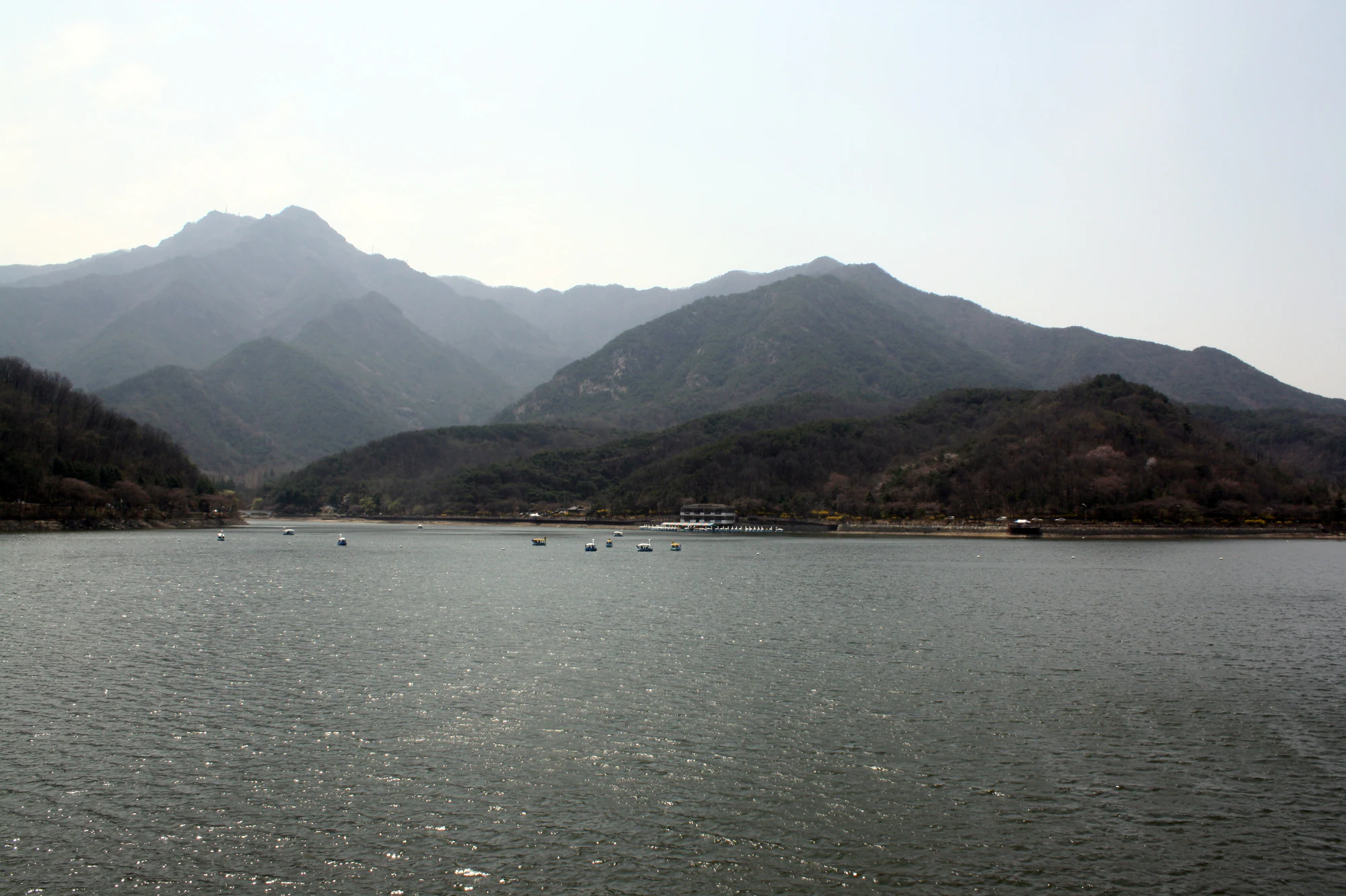
Small boats dot a broad reservoir beneath wooded mountain ridges and a pale, hazy sky.

Reservoir-and-mountain scenery at Geumosan in April 2011. “Untitled” by Joamm Tall / Flickr, CC BY-SA 2.0. Unmodified historical photograph; boats shown do not establish present-day services.

“Untitled” by Joamm Tall / Flickr, CC BY-SA 2.0. Unmodified. · Creative Commons 1 · Creative Commons 2 · Creative Commons 3

Walks and routes

Geumoji reservoir circuit

Follow the waterside circuit for the skyline and reflections. The park office advertises 2.7 km; the newer accessible-tourism page describes 2.4 km, so do not use either figure as a precisely surveyed shared route. Allow 45–75 minutes, longer with stops.

Lower-level walking; assess deck surfaces and the particular entrance you use. The accessible forest improvements do not certify every reservoir segment.


Geumoji reservoir circuit

Daehye Falls out-and-back

Take the signed main mountain approach and make the falls your turnaround. Water draining from the high basin feeds this valley and then the reservoir below. The climb gives a different sense of scale from the lakeside; leave time to descend carefully.

Uphill mountain path with steps and uneven footing; suitable walking shoes are essential.

Daehye Falls out-and-back

Main trail to Hyeonwolbong

The official sequence is visitor information center → waterfall → inner fortress → summit, published as 3.2 km to the summit. The 976 m figure is summit elevation, not ascent gain. Returning the same way is an editorial option; allow 5–7 hours overall with breaks and approach time.

Demanding ascent with steep, rocky sections. A short published distance should not be mistaken for an easy walk.

Main trail to Hyeonwolbong

Hyeonggok-dong via the viewpoint to Geumoji

Published link: Hyeonggok-dong → Hyeonggok Viewpoint → Geumoji, 2.9 km.

Hillside walking; step-free access is not established.

Hyeonggok-dong via the viewpoint to Geumoji

Hyeonggok Viewpoint to Daegwanjeong

Published link: Hyeonggok Viewpoint → Daegwanjeong, 2.0 km.

A hillside route, not part of the accessible forest circuit.

Hyeonggok Viewpoint to Daegwanjeong

Hyeonggok-dong to Daegwanjeong

Published link: Hyeonggok-dong → Daegwanjeong, 1.0 km.

No verified gradient profile; choose according to on-site conditions.

Hyeonggok-dong to Daegwanjeong

Hyeonggok-dong to Hyeonggok Viewpoint

Published link: Hyeonggok-dong → Hyeonggok Viewpoint, 1.1 km.

Hillside approach; do not equate the short distance with level access.

Hyeonggok-dong to Hyeonggok Viewpoint

A gentle half-day

Begin with a manageable section of the reservoir circuit, then spend time on the Eco-healing Forest paths. Add Chaemijeong if the approach suits you, or continue the cultural theme indoors at the nearby history museum. Leave space for a meal rather than trying to fit in the waterfall as an afterthought.

Waterfall morning

Check the main trail at the visitor area, walk up to Daehye Falls and return the same way. Use the cable car only if it suits the day’s service and your mobility; you still need to assess the onward walk. Finish with a lower-level stroll only if everyone has energy left.

Use the official trail page and map to match the named links above. Other published summit itineraries pass through Seongan, Kaldabong or Beopseongsa and have different start and finish points. They should not be combined into a loop without checking every section and arranging the return. In particular, the office’s four-hour Course 1 finishes at Beopseongsa after the summit; that timing is not a promise for an out-and-back from your car.

Things to try

A pavilion stop with a local story

Chaemijeong was built in 1768 to honor Gil Jae’s learning and loyalty to the fallen Goryeo dynasty. Its setting beside a stream at the mountain’s foot makes it a natural cultural pause before or after a lower-level walk. Look at how the pavilion, water and trees compose a historic landscape, rather than treating it simply as a summit-day checkpoint.

Photograph the mountain from below

The reservoir lets you include both water and the mountain’s wooded profile in one frame. Try a calm spell for reflections, or use ripples as foreground texture. Stay on the path and let other walkers pass; the best photograph does not require crossing a barrier or approaching the water’s edge.

Gumi Neo-Confucianism History Museum

The nearby museum offers a useful continuation of the area’s cultural story. Its published hours are 09:00–18:00, last admission 17:30, with free entry. It closes on Mondays, 1 January, and the days of Seollal and Chuseok. Groups of 20 or more need advance booking. Check the museum notice before relying on it as your rainy-day plan.

Wildlife and habitats

Pines

The park’s historical vegetation account describes pine-dominated and mixed woodland. Pines, grouped botanically as Pinus, give the mountain much of its evergreen structure. Needles and cones help distinguish species; use a reliable tree guide or an on-site label before naming a particular tree.

Sawtooth oak

Sawtooth oak appears in the park’s vegetation account and map. Its narrow, sharply toothed leaves are a useful identification starting point. Confirm the whole tree rather than identifying it from one distant leaf; leave acorns for the woodland food web.

Larches

The park’s historical account links larch stands around Seongan to planting for timber. Larches belong to the botanical group Larix and, unlike most conifers, shed their needles for winter. Their planted origin adds another layer to the landscape. Check a tree guide or a reliable label before narrowing an individual tree to a species.

Stories and discoveries

A village high inside the fortress

Seongan was once a farming settlement inside the mountain defenses. Historical accounts describe wells and ponds, upland crops and families who left the mountain during the 1970s. Remembering that everyday life changes the way the upper basin reads: this was a lived-in landscape as well as a stronghold.

A cliff-backed summit basin

Geumosan rises abruptly above relatively open surrounding country. Its steep outer slopes conceal an upper basin that helped support settlement and defense. On a clear hiking day, the change from enclosed valley to higher ground is as memorable as the summit marker.

When to visit

spring

Spring brings fresh foliage, but much of it falls inside the seasonal trail-control period. Choose a designated open route and carry a layer for shaded or higher sections.

summer

The valley can feel refreshing, and waterfall flow changes with rainfall and management of the upstream regulating pool. Heavy rain is a reason to postpone a valley hike, not to pursue the largest cascade. The lower forest’s planted lilyturf display is usually associated with August, with flowering dependent on conditions.

autumn

Use a clear autumn day for the forest-and-water combination, but plan around shortening daylight. From 1 November the general seasonal restrictions apply to routes outside the designated open list.

winter

Keep the day shorter when conditions are cold. Wet steps and shaded rock can freeze; if you lack the equipment or confidence for the descent, choose the lower visit or an indoor alternative. Check the winter cable-car timetable separately.

Getting there and practical advice

Cable car: costs and timing

The published service covers 805 m to beside Haeunsa in about 6½ minutes. Individual fares are KRW 7,000 one way or 12,000 return for adults, and KRW 5,000 or 7,000 for children. The page lists a 09:00 start and 15-minute intervals, with the end varying by season. Call 054-452-4488 for the day’s operation, last descent and boarding requirements; wind, queues or maintenance can change the plan.

Parking and lower-area services

Gumi Urban Corporation lists passenger-car parking at KRW 1,500 in lots 1–4, with chargeable hours of 08:30–17:30 daily. The large lot below the reservoir has a different system: free 04:00–24:00, charged overnight. Read the current entrance board and choose the lot for your starting point. These parking hours are not park opening hours.

Camping is a separate plan

If you intend to stay overnight, use the official campground information and reservation service. Winter water and toilet shutdowns have occurred, so verify the current season’s facilities rather than arriving with only a tent. Day-visit trail information does not establish where camping is permitted.

From Gumi Station

A city notice dated 22 April 2026 identifies bus 27-3 between Gumi Station and Geumosan parking, with the decorated “Nangman Tomi” service introduced that month. Route 27 also appears in the nearby museum’s directions. Check the Gumi bus information system for the actual departure, stop and return service on your date; do not rely on an old hourly-frequency estimate.

Choose the right destination

For the lower accessible forest, the published address is 341 Geumosan-ro, Gumi. The history museum is at 336-13 Geumosan-ro. Tell a driver which entrance or parking area you want; the whole provincial park is much larger than this visitor district.

Eco-healing Forest: what is documented

Korea Tourism Organization’s May 2026 update records six accessible parking bays, a modified crossing, an accessible toilet with ramp, tactile/audio information and deck walking routes. It gives forest-path gradients of 1:14–1:25. These improvements are useful, but a gentle gradient can still require effort: check the access map, choose a suitable turning point and ask about temporary obstructions.

Where the accessibility claim stops

The above facilities belong to the lower forest area. No equivalent step-free verification is available for the full waterfall approach, the summit, Doseongul cave or the temple detours. Contact the park office on 054-480-4604 with your exact route and mobility needs before committing to those sections.

Visitor information

Before you choose a trail

As checked on 18 October 2026, the Hyeonggok Viewpoint outdoor stage is suspended for connecting-bridge works, with the latest extension giving December 2026 as the planned end. Older text on the same booking page still says October. Avoid the work area and ask about the connecting paths; this notice does not close the whole park. Before a November–May hike, check the current seasonal order as well as the general open-route list.

Sources and useful links

Wildlife you might spot

3

Each card links to a full Explore page with photos, traits, and fun facts.

Snap map for this place

Start with the big picture, then zoom in to explore individual wildlife observations around this place.

Loading map…

Good to know before you go

Pack water and a snack before leaving the lower visitor area; do not depend on mountain springs as drinking-water supplies.

Set a turnaround time before ascending, leaving daylight and energy for the descent.

Use the official route names and signs at junctions; an attractive side path may be seasonally closed.

Keep children close on waterside decks, stairs and exposed mountain sections.

Carry out food scraps and leave plants, cones and acorns where they are.

Check your return bus or cable-car arrangements before the walk, rather than after reaching the last stop.

Frequently asked questions

No. It ends beside Haeunsa Temple, below the upper mountain. Plan any summit ascent as a separate hike and confirm the last descent before boarding.
Yes. Make the reservoir edge and Eco-healing Forest your main outing. A shorter out-and-back lets you return before fatigue becomes a problem.
No. The published seasonal system exempts designated routes. Use the linked official open-route list and the current-year order, then obey any additional local closure.
Make Daehye Falls your turnaround and descend by the same signed approach. This is still an uphill outing with steps and uneven ground, so allow enough time and energy for the return.

Recent snaps at this place

Recent snaps will appear here as new observations are added.

View all ›

Take the discovery with you

Exploring Geumosan Provincial Park?

Identify the wildlife you spot, learn as you go, and keep a collection of the adventure.

  1. 1Spot it
  2. 2Snap it
  3. 3Keep the discovery






