
Snappit logo
Snappit
Get App
Generic illustration, not a photograph of this venueIllustration
ParkBR

Ilha do Mel State Park

The park occupies roughly 338 hectares on the southern part of Ilha do Mel, in Paranaguá municipality.

About

The park occupies roughly 338 hectares on the southern part of Ilha do Mel, in Paranaguá municipality. It protects a close meeting of Atlantic Forest, coastal restinga vegetation, beaches and rocky shores. A walk can shift from sheltered greenery to bright sand in minutes, so the experience feels varied without needing a summit or an ambitious mileage target.

Ilha do Mel is also a lived-in island, not one continuous visitor attraction. Encantadas and Nova Brasília are arrival communities; the much larger ecological station protects the northern area. The lighthouse and fortress belong to the broader island itinerary and have their own land-use and access context. Decide which landing suits your day before buying a crossing.

For a first visit, Encantadas and the cave approach make a satisfying southern introduction. A longer stay lets you give the Farol das Conchas viewpoint and the island’s history a separate day. Leave room for an unhurried meal, a change in the weather and the simple enjoyment of watching the coast without having to move on. Be ready to snap and learn! Get the Snappit app to identify any nature species you find here.

What to do here

Choose a marked coastal walk, pause where forest meets beach and observe the cave from a safe, currently permitted position. Add a viewpoint only when everyone has enough energy for the return. The itinerary should follow the weather and tide, not the number of attractions on a checklist.

Seasonal info

Summer visits need extra attention to sun, water and busy holiday transport. Cooler periods can suit walking, but bring a layer for wind and the boat ride. Rain or rough seas can change the plan in any season; a quiet beach is not proof of safe conditions.

Accessibility

Boat boarding, sand, uneven paths and steps require individual planning. The lighthouse approach includes a substantial staircase. No continuous step-free park itinerary is verified here; discuss the complete journey with the operator and accommodation before committing.

Don't miss

1

The sea-shaped entrance of Gruta das Encantadas.

2

Ocean-facing beaches framed by rocky headlands and coastal forest.

3

Quiet bird observation from established paths.

4

The wider island’s lighthouse viewpoint and eighteenth-century fortress, with separate access checks.

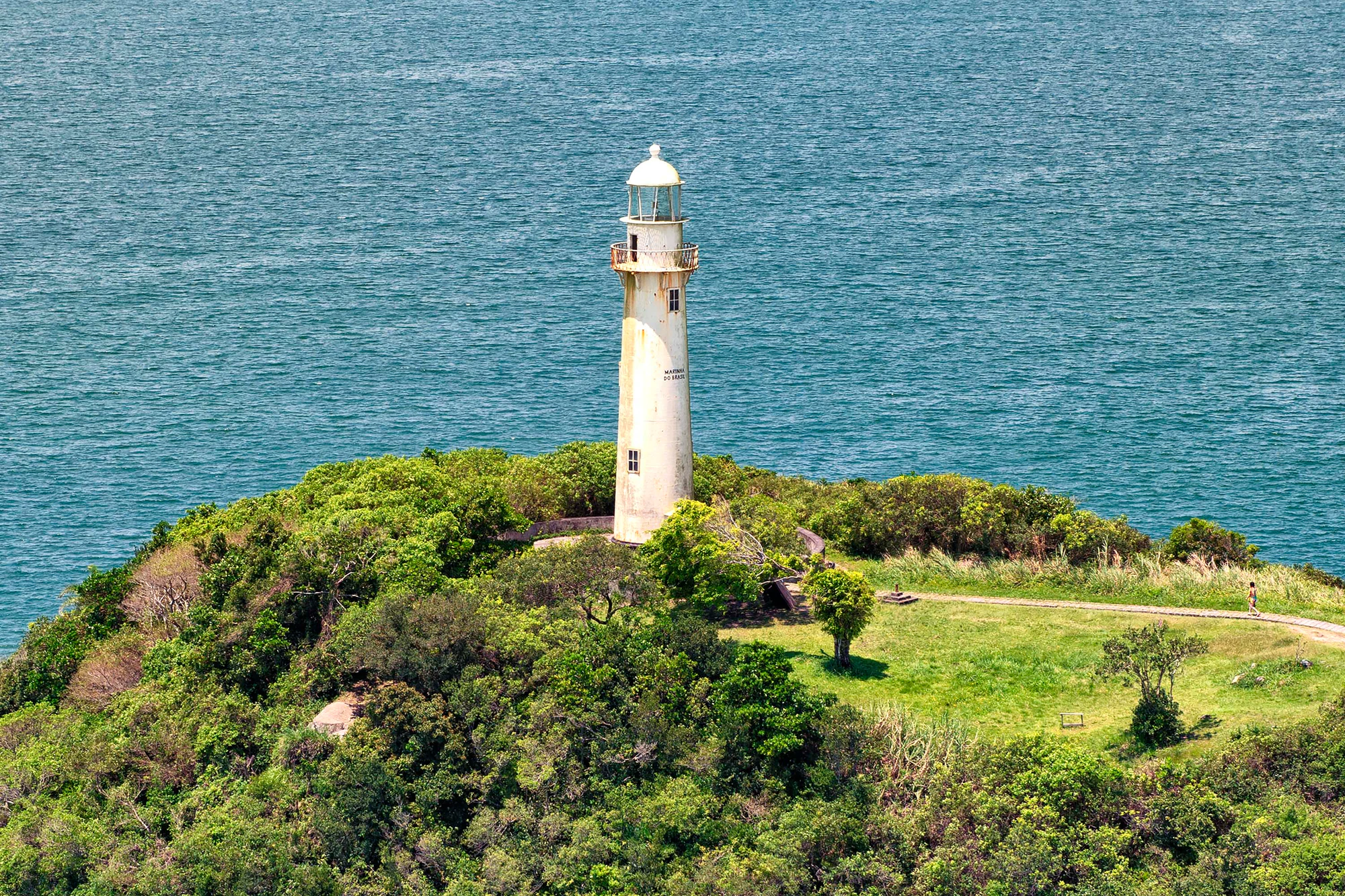
A pale lighthouse on a green coastal headland, with the blue sea behind it and a small visitor on a path to the right.

A lighthouse above coastal vegetation and the sea on Ilha do Mel. Archival photograph; the exact capture date is unverified. The image does not establish access to the tower or current visitor conditions.

Denis Ferreira Netto/SEDEST · Creative Commons

Walks and routes

Encantadas to the cave approach

From the Encantadas landing, follow the signed approach towards Gruta das Encantadas. Official tourism guidance gives about 600 metres to the cave, not a 600-metre return loop. Make the shoreline view the objective; entering the opening is optional and must depend on safe conditions and local instructions. Return the way you came rather than improvising a continuation around rocks.

Allow one to two hours with pauses, as an editorial visit budget.

Farol das Conchas: a wider-island viewpoint

Use Nova Brasília as the arrival base for a separately planned lighthouse outing. The final approach includes about 150 steps. Pause before committing to the staircase if heat, balance or fatigue is a concern; the descent still lies ahead. Enjoy the exterior and coastal outlook without assuming that the tower, service areas or every visible headland is open to visitors.

Reserve a relaxed half-day around arrival, walking, the viewpoint and a meal; this is not a measured route time.

Fortress: a separate heritage excursion

Fortaleza de Nossa Senhora dos Prazeres stands outside the southern park outing. IAT describes an approximately four-kilometre approach from Brasília’s landing, so budget for the return as well. Confirm the permitted approach, entrance, opening and any interior or Morro da Baleia restrictions locally. A boat landing or booked tour does not itself authorize access to closed structures, military areas or the ecological station.

Give the excursion its own substantial part of a day rather than adding it to a rushed cave-and-lighthouse circuit.

Things to try

A small family field notebook

Choose one short outing and ask children to notice three textures: sand, rock and leaves. Draw or photograph them without taking samples. Build in a snack and an early return option; the goal is curiosity, not reaching the deepest part of the cave or completing a long crossing between villages.

Birdwatch without chasing

IAT’s park bird guide includes yellow-crowned night heron, Neotropic cormorant and semipalmated plover. Bring binoculars if you have them, stop quietly and let birds keep their distance. These are documented wild possibilities, not guaranteed sightings; photographs in an identification guide do not mark where an individual will be today.

Read the landscape from dry ground

Compare sheltered vegetation with the exposed shore from an established path. Notice how a headland changes the view and where the sea reaches the rocks. Make notes or photographs from a safe distance instead of walking onto a wet ledge for a better angle.

Stories and discoveries

Two conservation histories

The ecological station dates to 1982 and the state park to 2002. They protect connected environments but serve different visitor purposes; that distinction matters more than the shorthand claim that the island is a park.

The sea found the weaker rock

The geological interpretation published by IAT explains that the cave formed where the sea eroded a band of diabase more readily than the surrounding migmatite. From a safe viewpoint, it is a chance to connect a striking shape with the different resistance of the rocks, without collecting a souvenir fragment.

A fortress built for the bay

The specialist Paraná heritage record dates the fortress’s construction to 1767–1769 and links it to Portuguese colonial defense. Its walls are a reason to look at the bay as a historic route, while remembering that this military history also sits within a wider history of colonization and enslaved labor.

When to visit

Hot days and summer holidays

Keep the exposed part short, take shade breaks and leave spare time at the terminal. Check accommodation and transport before travelling, rather than treating an island capacity figure as a reservation.

Cooler, quieter outings

Use comfortable walking conditions for a slower observation day. Carry a windproof layer and confirm services before relying on them; fewer visitors do not remove tide, surf or slippery-rock hazards.

Rain, wind or a poor tide window

Choose a community-based pause or postpone the excursion. A previous visitor’s successful beach crossing does not establish that today’s route is passable. Do not try to beat the tide or a departing boat.

Getting there and practical advice

Choose the landing before the boat

Pontal do Sul’s public terminal is the straightforward published starting point for ABALINE crossings to Encantadas or Nova Brasília, usually described as about 30 minutes. Paraná also lists a longer boat approach from Paranaguá, around 90 minutes, but a current departure schedule for that route was not verified. Confirm it before arranging connecting transport.

Agepar advises using authorized ticket sellers, the public terminal and approved vessels. Check the current ticket or wristband procedure at the terminal. Refuse an unsolicited alternative embarkation offered on the road or in a car park.

Check every link in the journey

Ask the boat operator about the exact vessel, gangway, boarding assistance and how tide changes affect the transfer. Then ask your accommodation about the route from the landing, sand depth, steps, bathroom layout and available help. A suitable room does not guarantee a suitable approach.

Use the communities as your planning bases

Arrange accommodation, meals and drinking water around your chosen village, not around an assumed visitor centre in the protected interior. Confirm toilets, opening hours and any luggage arrangements directly. Carry enough water for the outing and conserve the island’s supply; bring essential medication and do not rely on an immediate mainland return if boats stop.

The tide is part of the route

This is an active seashore, not an enclosed cave attraction. The official geological guide explains how marine erosion formed the opening; treat tide, swell and current local instructions as essential to deciding how near to go. Ask lifeguards or local staff before approaching, and never wade or scramble past a wave-washed obstruction to keep an itinerary intact.

Sources and useful links

Wildlife you might spot

3

Each card links to a full Explore page with photos, traits, and fun facts.

We are still adding species preview cards for this place.

Snap map for this place

Start with the big picture, then zoom in to explore individual wildlife observations around this place.

Loading map…

Good to know before you go

Pack light enough to carry your own essentials along sandy paths. Keep drinking water, food, rain protection, sun protection, repellent and a charged phone with you; do not count on finding supplies after leaving the community.

Photograph or save the confirmed return arrangements before walking away from the landing. Agree a generous turnaround time with companions, including time for a slower walker and a change of plan.

Use village businesses respectfully

ask before photographing residents, keep noise down and take your litter back. A place that looks like a shortcut may be a private yard or sensitive vegetation rather than a public path.

Frequently asked questions

No. The park, ecological station, villages and specially managed heritage areas are distinct. Public recreation in the park does not authorize entry into the ecological station: IAT permits public visits there only with authorization and an educational purpose.
On 22 October 2026, ABALINE’s timetable page listed the Pontal do Sul tourist crossing at R$49 per person, round trip. Confirm the fare when purchasing; parking, accommodation, meals and optional services are separate. A current separate park-entry tariff was not verified, and future island-access arrangements may change.
IAT’s 15 October 2026 notice described registration for residents first, with the tourist phase still lacking a launch date. Check the latest official instructions before travel. Do not mistake that rollout announcement for a completed tourist booking system.
No. IAT’s administrative listing gives 24-hour park access subject to management and weather changes; boats have separate schedules. ABALINE’s homepage and timetable show different departure windows, so confirm your actual return instead of relying on a generic last-boat time.
The park’s prohibited-activities list includes camping and domestic animals. Authorized accommodation or camping elsewhere on the island is not permission to camp inside the park. If you require an assistance animal, ask about the applicable access arrangements before booking.
Do not plan on entering it. The viewpoint and the tower are different experiences. SEDEST’s historical guidance says the Navy’s tower was not open internally; no current authorization for interior visits was verified.
For crossings, ABALINE publishes WhatsApp +55 (41) 3455-2616. For local management, the October 2026 IAT notice lists Unadim contacts in Nova Brasília, +55 (41) 99116-0189, and Encantadas, +55 (41) 98413-4224. Explain your date, arrival point and any specific access needs.

Recent snaps at this place

Recent snaps will appear here as new observations are added.

View all ›

Take the discovery with you

Exploring Ilha do Mel State Park?

Identify the wildlife you spot, learn as you go, and keep a collection of the adventure.

  1. 1Spot it
  2. 2Snap it
  3. 3Keep the discovery
