
Snappit logo
Snappit
Get App
Generic illustration, not a photograph of this venueIllustration
ParkKR

Maisan Provincial Park

Maisan rewards a choice made before you arrive: come for the temples and rock scenery, or set aside a proper hiking day.

About

Maisan rewards a choice made before you arrive: come for the temples and rock scenery, or set aside a proper hiking day. From the south, the approach through Geumdangsa and Tapyeongje reservoir leads to Tapsa’s remarkable stone towers. Continue towards Eunsusa to see the rock walls close up and discover the park’s botanical heritage.

The north entrance reaches the pass between the peaks, so a north–south crossing involves climbing even without a summit. Ammaibong is an optional, steep extension that closes in winter and bad weather. The western ridges around Gogumdang and Biryongdae broaden the park beyond its famous silhouette. Leave enough time to look back at the twin peaks rather than treating the summit as the only worthwhile destination. Turn your visit into a safari! Use the Snappit app to scan and log wildlife sightings here.

Maisan became a provincial park in 1979. Its name refers to the horse-ear appearance of the two principal peaks. The cultural landscape is layered: Geumdangsa occupies a site rebuilt in 1675, while its earliest foundation is disputed; Eunsusa preserves traditions linking the mountain with Yi Seong-gye, founder of Joseon. Treat those stories as traditions rather than proof of who planted a particular tree. Tapsa’s towers belong to the human-made temple landscape, distinct from the naturally formed conglomerate peaks.

What to do here

Walk the temple corridor, pause at Tapyeongje, and compare the naturally weathered cliffs with the carefully stacked towers at Tapsa. At Eunsusa, look for the interpretation panels for the protected pear tree and creeping-spindle population. Choose a signed ridge route only when weather, access and your group’s stamina allow.

Seasonal info

Plan winter visits around lower paths that the operator confirms are open. Ammaibong’s steep route is seasonally closed and may also close for rain or fog. In summer, carry water and leave exposed rock for another day if storms are forecast. Seasonal colours never override a closure.

Accessibility

The cross-park route and summit approaches involve slopes and steps. Do not assume that a temple destination or a maintained trail is step-free. Visitors who need a level route should ask the park office about the exact entrance, current surfaces, toilets and permitted drop-off before travelling.

Don't miss

1

The horse-ear outline of Ammaibong and Sumaibong

2

Tapsa’s human-built stone towers beneath the cliffs

3

Eunsusa’s protected pear tree and creeping-spindle population

4

Tapyeongje and the southern cherry-blossom approach

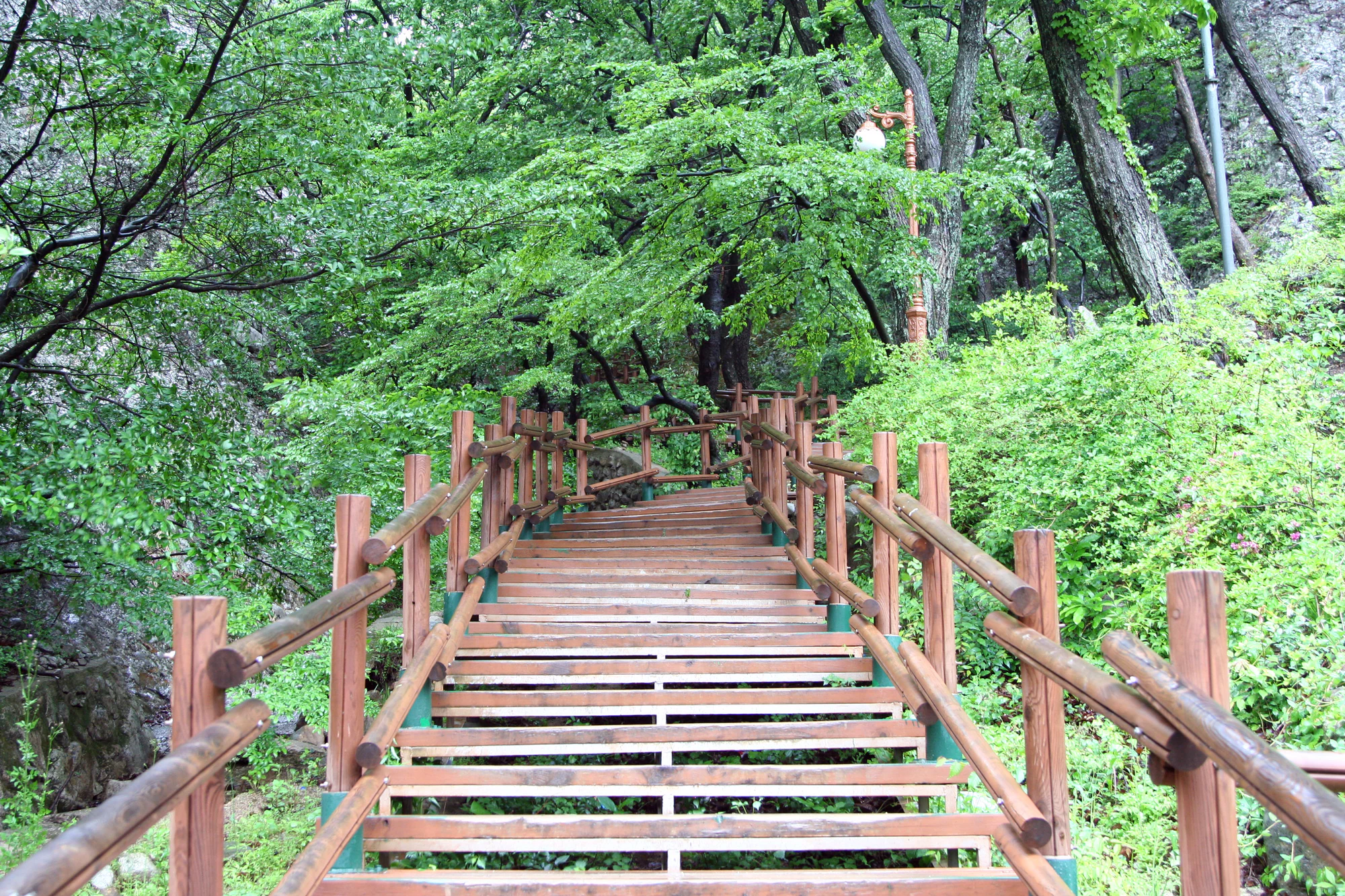
Brown-railed open steps climb between rock faces and dense green woodland, with lamps beside the path.

Wooded steps at Maisan, photographed on 23 May 2010. The photographer describes stairs leading away from a temple, without identifying the exact section. This older view does not establish today’s route condition or access.

“Maisan (13)” by Ben Kucinski, via Flickr, CC BY 2.0. No changes. · Creative Commons 1 · Creative Commons 2

Walks and routes

South entrance to Tapsa and Eunsusa, then back

Follow the signed southern approach past Geumdangsa and Tapyeongje to Tapsa, then continue to Eunsusa if time and conditions suit. Returning the same way avoids an onward-transfer problem. Give the temples time rather than racing between them; a 2–3 hour visit is a useful starting allowance, with more for meals or crowded blossom days.

An uphill walking visit with changes of surface and steps near attractions; no continuous step-free route has been verified.


South entrance to Tapsa and Eunsusa, then back

North–south temple crossing

The county publishes a 3.3 km crossing from the northern tourism-complex parking area via the pass, Eunsusa, Tapsa, Tapyeongje and Geumdangsa to south parking, with 1½–2 hours of walking. Add time for visits. The route can be reversed; agree on a pickup point at the far entrance before setting off.

There is an ascent to the pass and a descent on the other side. This is not a flat valley stroll or a wheelchair crossing.

North–south temple crossing

Gogumdang–Biryongdae–Bongdubong ridge

For a broader mountain outing, the county lists south parking → Gogumdang → Biryongdae → Seonghwangdang → Bongdubong → Tapsa → Eunsusa → the pass → northern tourism-complex parking. Its published 5.7 km and 3½–4 hours describe walking, so plan a longer day with breaks and transport. Biryongdae gives a different relationship to the peaks from the temple corridor.

A mountain trail with climbs and rocky sections. The operator’s general description as maintained is not an accessibility assessment or a guarantee of suitability for small children.

Gogumdang–Biryongdae–Bongdubong ridge

Ammaibong as a conditional extension

The county advises allowing roughly another 1–1½ hours for the pass–Ammaibong excursion in its longer-route guidance. Decide at the signed junction whether there is enough daylight and energy for the climb and descent. Give yourself time for the descent as well as the climb.

Steep terrain and slippery or icy sections make this unsuitable as an easy add-on for anyone uncomfortable with exposed mountain walking.

Ammaibong as a conditional extension

A relaxed first half-day

Arrive at the south entrance with enough time for an unhurried return. Walk past Geumdangsa, pause at the reservoir, then make Tapsa the main stop. Continue to Eunsusa for the plants and cliff setting if everyone is comfortable with the climb. Return before tired legs turn the last section into a rush, then eat near your chosen departure point. Leave the summit for another visit if the day is already full.

A hiking day with an escape from summit pressure

Choose either the published western ridge traverse or a temple crossing with an open Ammaibong extension. Check every section first, carry lunch, and keep a firm turnaround time. If the summit gate is closed or the rocks are wet, enjoy the lower route only if staff confirm it is safe and open. A summit closure is a completed decision, not an invitation to find another way up.

Things to try

Read the rock from the path

Maisan is made largely of conglomerate: rounded stones bound into a finer matrix, deposited in the Cretaceous and later lifted and eroded. The conspicuous hollows in the southern rock faces are called tafoni. Look from an established path or viewing area; there is no need to approach the cliff base or remove a sample to appreciate the texture.

Spend time at Tapsa

The county describes around eighty stone towers of varied shapes beneath Ammaibong, with the Cheonji towers forming the upper focal point. Notice how narrow stacks differ from broader cones. They are religious and cultural structures: do not lean on them, add stones or test their balance. Stories about surviving storms are not a reason to stand beneath cliffs in bad weather.

Pause beside Tapyeongje

This artificial reservoir sits along the southern approach. It is a good place to slow the visit down, compare the wooded slopes with the bare rock beyond, and take a photograph from the established path. Reflections depend on wind and light; the towers are not guaranteed to appear in the water. The poetry monument nearby adds a quieter cultural stop.

When rain changes the day

Avoid turning a temple walk into shelter-seeking beneath rock faces. The county warns about rockfall and slippery rock after rain, and routes can close. In persistent rain or a weather warning, postpone the mountain walk and spend the time in Jinan instead; check any indoor destination’s opening hours separately. Do not make an unverified detour around a barrier.

Wildlife and habitats

Fortune’s creeping spindle

At Eunsusa and the neighbouring Sumaibong cliffs, heritage interpretation identifies a protected population of the evergreen climbing plant Euonymus fortunei var. radicans. Look for its labelled interpretation and view the vegetation from permitted ground. Its climbing habit is part of what makes this a distinctive plant stop; do not scramble onto the rock for a closer photograph. The guide’s species link is to the broader Euonymus fortunei record.

Cheongsil pear at Eunsusa

The old pear in Eunsusa’s grounds is a protected individual tree, described in heritage sources as Pyrus ussuriensis var. ovoidea. Appreciate its branching form from outside the protection area. The story that Yi Seong-gye planted it is a local tradition. Here it is linked only at the broad pear genus, Pyrus; that link does not identify other pear trees you may see in the park.

Stories and discoveries

Two peaks, different outlines

The county lists western Ammaibong at 687.4 m and eastern Sumaibong at 681.1 m above sea level. These are summit elevations, not the climb from a car park. Look at their outlines from different permitted viewpoints: the familiar paired silhouette changes as you move around the mountain.

When to visit

Spring blossom without a fixed peak date

The southern cherry-lined approach is the spring focus, usually in April. The county describes a later display than many lower areas, so check recent local flowering updates instead of booking solely against another city’s blossom dates. Leave extra time for arrival and choose a simple return route when the paths are busy.

Summer shade and autumn ridges

Woodland makes the approach pleasant in leaf, but shade does not remove heat or storm risk. In autumn, a clear day is an opportunity for the western ridge views and foliage. Start with the walking time your group can comfortably manage and preserve a margin for a slow descent.

Winter with a lower-level plan

Expect Ammaibong’s seasonal closure and check the remaining paths individually. Frost can turn a modest incline into a difficult section. Choose a short outing in daylight and be willing to cancel if the operator closes routes; a picturesque snow forecast is not a safety assessment.

Getting there and practical advice

Food, toilets and practical stops

Use the entrance areas to sort out food, water and the nearest open toilet before climbing. The county website has a park restaurant directory; business hours and menus need a fresh check. Carry out your litter and do not rely on finding supplies along a ridge.

Choose a precise arrival point

The county gives the south navigation address as 182 Maisannam-ro, Maryeong-myeon, Jinan-gun, and the north address as 130 Maisan-ro, Jinan-eup, Jinan-gun. Both are in Jeonbuk Special Self-Governing Province. Use the official directions and the entrance name, rather than a general mountain pin.

Public transport and the last leg

Jinan is the local bus gateway; the county describes connections from Jeonju and lists local bus and taxi contacts. Check the actual day’s service to your chosen entrance and the return departure before committing to a crossing. Its undated timetable should not be treated as a current promise. The published Jinan intercity terminal contact is 063-433-2508 and the local bus operator is 063-433-5282.

Plan around the actual barriers

If stairs are a barrier, discuss a short entrance-area visit with the office rather than assuming you can reach all the temples. Confirm toilet access, gradients and turnaround points for your own equipment. The county describes limited disability-related vehicle exceptions on the south side; arrange permission and required documentation in advance on 063-430-8095. This is not a promise of vehicle access to every attraction.

Visitor information

Check the route before leaving

Checked 18 October 2026. Consult the county park website for fresh notices and confirm the exact route with the management office on 063-430-8094 or 063-430-8095. A September reopening notice lifted an earlier rain closure; it does not establish that every trail is open today.

Cycles, scooters and motorcycles

The 6 July 2026 notice restricts entry and operation of bicycles, including mountain bikes, motorcycles including quad bikes, and personal mobility devices such as electric scooters throughout park trails and other park areas until lifted. Village areas and areas open to general vehicles are excepted. Do not use a cycling route suggested by an old map without checking this notice.

Designated paths only

A county notice bars unauthorised entry to undesignated trails from 20 June 2025 to 19 June 2029. Even designated paths may close for fire prevention, severe weather or unfinished works. Rock climbing is prohibited throughout the park; a visible track or a photograph is not permission to enter.

Sources and useful links

Wildlife you might spot

2

Each card links to a full Explore page with photos, traits, and fun facts.

Snap map for this place

Start with the big picture, then zoom in to explore individual wildlife observations around this place.

Loading map…

Good to know before you go

Choose south or north parking before setting your navigation; a crossing finishes on the other side of the mountain.

Carry a layer, drinking water and footwear with a secure grip. Keep your hands free on steep sections.

Stay on designated paths and behind temple or plant-protection barriers. Leave stones, fruit and branches where they are.

Keep voices low around worshippers and ask before photographing religious activities or entering buildings.

Arrange the return journey before starting a one-way walk, especially if relying on a rural bus or taxi.

Frequently asked questions

For Tapsa, the reservoir and a return to your car, the southern approach is a straightforward plan. Choose the north for the pass between the peaks, or arrange a one-way crossing. Neither choice makes the whole route level.
This guide’s summit option is Ammaibong only, and only when the designated route is open. Do not improvise an ascent of Sumaibong or climb the cliff faces. The county prohibits rock climbing throughout the park.
The county FAQ lists park admission and parking as free, but Tapsa collects a separate heritage-viewing charge, including when you pass through its ticketed area. Confirm the current amount and exemptions with Tapsa on 063-433-0012.
No. The county says the privately operated train serves only the northern Lovers’ Path. Its terminus still leaves a walk over the pass to Tapsa; confirm service with the operator.
The county FAQ prohibits entry with pets. Bicycles and other vehicles covered by the July 2026 notice are restricted on park trails; see the exceptions in the access section. Ask the office separately about assistance animals or disability mobility equipment.
No. The twin peaks and their weathered hollows are geological features; the towers at Tapsa were stacked by people. The protected plants at Eunsusa are separate natural-heritage features.

Recent snaps at this place

Recent snaps will appear here as new observations are added.

View all ›

Take the discovery with you

Exploring Maisan Provincial Park?

Identify the wildlife you spot, learn as you go, and keep a collection of the adventure.

  1. 1Spot it
  2. 2Snap it
  3. 3Keep the discovery




