
Snappit logo
Snappit
Get App
Generic illustration, not a photograph of this venueIllustration
ParkKR

Palgongsan National Park

Palgongsan feels different depending on where you begin.

About

Palgongsan feels different depending on where you begin. Around Donghwasa, temple courtyards and forested approaches make a satisfying outing without a summit. Above Tapgol, steps and rocky ridges lead toward Dongbong. Farther east, Gatbawi draws pilgrims to the stone Buddha on Gwanbong, with distinctly different approaches from Daegu and Gyeongsan. Gasan’s fortress landscape and the Eunhaesa side deserve separate days rather than a hurried cross-mountain checklist.

This is the national park designated in 2023, covering 126.058 km² across Daegu and Gyeongsangbuk-do. Its highest peak, Birobong, reaches 1,193 m; Dongbong is 1,167 m. City proximity does not make the upper mountain an urban stroll. Pick your ascent and descent together, check the relevant closure notice, and leave time to return before darkness. Explore the grounds like a pro—download the Snappit app to instantly identify animals and plants.

Palgongsan was designated a provincial park in 1980. The national-park designation was announced in June 2023 and took effect on 31 December 2023; KNPS’s eastern and western offices opened on 1 January 2024. Its cultural importance is much older: the mountain was revered as Jungak, the central sacred mountain of Silla. Donghwasa and Eunhaesa remain active religious places within this larger mountain landscape.

What to do here

For a first visit with mixed walking abilities, make Donghwasa the main destination and add only a short walk that everyone can comfortably reverse. Fit walkers seeking mountain scenery can consider Tapgol–Dongbong after checking current controls. Choose Gatbawi when the pilgrimage site is your priority, and decide in advance whether you are approaching from Daegu or Gyeongsan. The two starting areas are not interchangeable.

Seasonal info

Spring and autumn can bring fire-prevention restrictions; summer rain can close paths and make valley steps slippery. Winter outings need suitable footwear, traction for ice and warm layers. The dated construction warning above affects several familiar approaches and takes priority over older guidebooks.

Accessibility

Dongbong and Gatbawi involve steep steps and uneven mountain surfaces. They are unsuitable as wheelchair or stroller routes. A lower temple visit is a different proposition, but do not assume continuous step-free access: ask about the specific entrance, slopes, toilets and parking you need before travelling.

Don't miss

1

Donghwasa’s temple landscape and Daeungjeon Hall

2

The ridge sequence above Tapgol and the approach to Dongbong

3

Gatbawi’s seated stone Buddha on Gwanbong

4

Gasan’s fortress remains and the quieter Eunhaesa-side forest

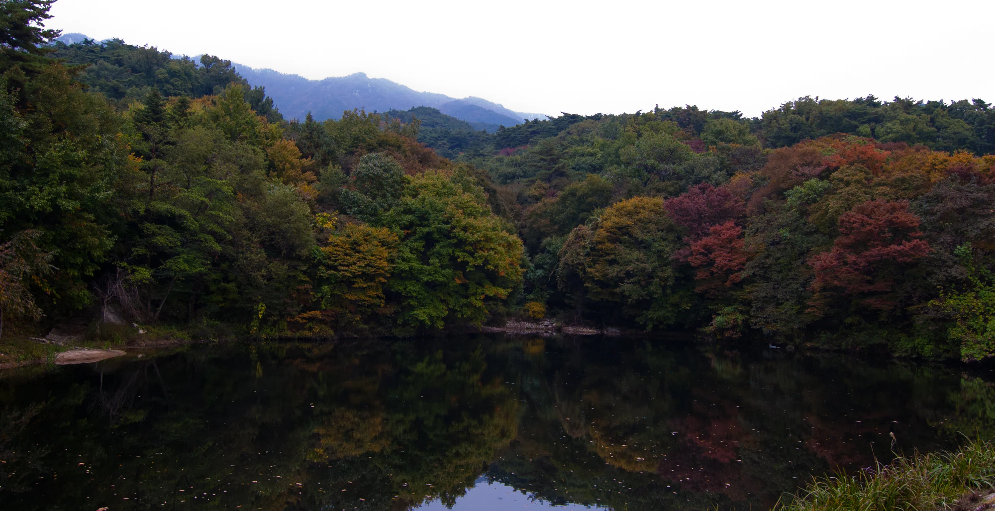
Dark pond water reflects green, yellow and rust-coloured woodland beneath a distant mountain ridge.

Autumn woodland, a pond and a distant ridge in Minyoung Choi’s Palgong Mountain entrance photograph, taken on 15 October 2011, before national-park designation.

“Palgong Mountain (팔공산) Entrance” by Minyoung Choi (mrmin123), Flickr, CC BY-SA 2.0. Unchanged original; no crop, resizing or re-encoding. · Creative Commons 1 · Creative Commons 2

Walks and routes

Tapgol to Dongbong: the mountain-day choice

Start at Tapgol information point and climb via Kkaltak Pass to the cable-car upper station at Sinlimbong, then continue through Naktabong and Cheoltap junction toward Dongbong. KNPS publishes 3.25 km and 2 hours 5 minutes for this one-way route, rated high difficulty. Its rounded segment labels total slightly less distance; use the whole-route figure for planning. Steep stone and wooden steps beyond the upper station mean the cable car removes only part of the climbing. Return the same way unless another descent has been specifically checked as open; do not descend the closed Sutaegol branch. Official route.

Tapgol to Dongbong: the mountain-day choice

Sutaegol to Dongbong: save for after confirmed reopening

This forest-and-stream approach passes the Sureung Bongsan boundary stone, climbing cliffs and Sutaegol Waterfall before reaching Cheoltap junction and Dongbong. KNPS publishes 3.85 km and 1 hour 55 minutes one way, rated medium difficulty. The lower section is described as gentler, while upper stone and wooden steps become steep. The boundary stone recalls the protection of forest supplying royal-tomb ritual charcoal. During the construction closure, neither the attractive lower valley nor the waterfall is a recommended workaround. Check reopening before making this your day’s plan. Official route.

Sutaegol to Dongbong: save for after confirmed reopening

Gatbawi from Daegu: the long stair ascent

From Gatbawi visitor centre, the published first section climbs 0.9 km to Gwanamsa in about 30 minutes. Another 0.9 km, listed at 60 minutes, reaches Gwanbong and its seated Buddha. KNPS describes 1,365 steps on the Gwanamsa ascent. Allow for rests and a careful descent; a paved beginning does not make the whole walk easy. For a simple return, retrace your ascent. The operator also describes a longer circuit toward Seonbonjae and the youth hostel, but its 4 km summary is not the distance from the visitor centre to the Buddha. Official route.

Gatbawi from Daegu: the long stair ascent

Gatbawi from Gyeongsan: Seonbonsa approach

The Seonbonsa–Gatbawi section is published as 1.1 km and 40 minutes, with a separate approach from Daehan parking to Seonbonsa described as about 600 m. KNPS calls this approach comparatively gentler, but still notes slopes and the need to match the walk to your fitness. Its whole-route summary instead lists 1.6 km and one hour from Daehan parking; the figures are not perfectly consistent, so do not combine them into a falsely precise total. Choose this side for a shorter ascent and arrange your return on the same side. Official route.

Gatbawi from Gyeongsan: Seonbonsa approach

Jinnammun to Gasanbong: fortress and forest

For a different side of Palgongsan, begin at Jinnammun near Haewonjeongsa and follow the route past the Cheonjusa temple site toward Gasanbong. KNPS publishes 4.7 km and 2 hours 35 minutes one way, with a low overall difficulty rating. That still means a substantial return walk. The initial 1.2 km to the rest pavilion is the gentler short-outing option described by the operator. Higher up, the route encounters fortress remains and forest; allow time for the history without assuming the summit is necessary. Official route.

Jinnammun to Gasanbong: fortress and forest

Sinilji toward Eunhaebong: choose your turnaround

On the Eunhaesa side, KNPS describes the first 1.5 km from Sinilji to Baekheungam as a gentle forest approach, taking about 40 minutes one way. A return here can suit visitors who want a quieter walk rather than a summit. Continuing to Eunhaebong makes a much longer undertaking: the full published route is 6.3 km and 3 hours 30 minutes one way. Respect any restrictions around the hermitages; a trail passing a religious site does not mean every courtyard or building is open to visitors. Official route.

Sinilji toward Eunhaebong: choose your turnaround

Half day: Donghwasa at an easy pace

Travel to the Donghwasa gateway, check the current entrance signs, and give the temple most of your time. Add a modest out-and-back on an open lower path only if everyone is comfortable. Keep the return bus or parking point fixed; there is no need to add a cable-car ride and a summit to make the visit worthwhile.

Full day: one confirmed mountain route

Check controls before departure, arrive early and walk the selected Tapgol–Dongbong route with a clear turnaround time. Rest before the final climb, then return on the checked route with daylight in hand. If the route is closed or conditions deteriorate, switch to a lower visit rather than searching for an unmarked bypass.

Things to try

A temple-first visit at Donghwasa

Start through the currently signed visitor entrance and spend time around Daeungjeon, the Joseon-period main hall, and the large outdoor Buddha. Look at the timber structure and painted eaves as carefully as the mountain backdrop. A May 2026 government-site visit report described Bonghwangmun under repair, so follow present signs rather than insisting on an old gate-to-gate circuit. This is a working temple: quiet courtyard time is more rewarding than trying to enter every building.

Photography without a summit target

A woodland or temple visit can work well when distant visibility is poor. Frame the relationship between forest and buildings from permitted paths, and keep steps clear when stopping. The historical photograph below offers landscape context, not a location pin or a record of today’s trail conditions.

When the mountain is a poor choice

In light rain, keep a temple visit short and use only open, secure paths; shelter does not remove slippery-surface risk. In heavy rain, thunder, strong wind or an official restriction, postpone the mountain outing and spend the day in Daegu. A cable car is weather-dependent infrastructure, not a guaranteed bad-weather alternative.

Wildlife and habitats

Martens beyond the busy gateways

KNPS identifies the yellow-throated marten among the park’s wildlife. Its yellow neck contrasts with a dark face, legs and tail, but seeing one is a chance encounter, not a reliable activity. Watch quietly from established paths, never follow an animal into cover and do not leave food. The associated species reference is the broader marten genus; it does not identify every marten species as present here.

Stories and discoveries

Forest protection has a long history here

The Sutaegol boundary stone is a reminder that protecting this mountain’s trees predates national-park status. Royal ritual needs shaped an earlier protected forest; today the same valley forms part of a public conservation landscape. See the stone only when the approach is confirmed open.

A cable-car viewpoint is its own destination

Sinlimbong’s upper-station viewpoint is about 820 m above sea level. It gives a different perspective on the higher rocky peaks without placing you on their summits. Continuing along the ridge should be a deliberate hiking decision.

When to visit

Spring, summer, autumn and winter

Spring: enjoy flowering shrubs along open trails, but check fire controls. Summer: favour a shorter start-to-return plan, carry extra water and abandon valley walking during heavy rain. Autumn: allow extra time for crowds and slippery leaves on the Gatbawi steps. Winter: shaded steps may remain icy even when the city is dry; bring traction and be ready to shorten the day. Exact flower and colour peaks vary with weather.

Treat older Olle descriptions carefully

Daegu’s published Sutaeji valley Olle page retains a June–September-only access warning. It is a different itinerary from the KNPS summit routes and should not be used as an assumed open detour around construction. Ask the park about the precise section you intend to use.

Getting there and practical advice

Get route advice at the right office

For the eastern office, call 053-989-8300; for the western office, 054-970-8300. Describe your exact start, destination and intended descent. Ask about works and the route’s current condition, not just whether the park is open. Confirm temple access and cable-car operation with their operators when those are central to your day.

Budget and provisions

Confirm parking charges before setting out. Temple parking, any optional activities and cable-car tickets are separate practical checks. Carry your own water and snacks for a mountain route; plan any meal around the gateway rather than assuming service along the ridge.

Choose the gateway before choosing the bus

Daegu’s April 2026 transport notice lists Express 1 and Palgong 1 toward Donghwasa, and 401 toward the Daegu Gatbawi side. Confirm the destination branch and the current last return on the Daegu bus information system. Seasonal Palgong services have different operating patterns; do not assume a weekend connection runs every day. The Gyeongsan-side Gatbawi approach is a separate arrival plan.

Useful arrival names for maps and taxis

KNPS lists Tapgol information point at Yongsu-dong 1-2, Dong-gu, Daegu; Daegu Gatbawi visitor centre at 229 Gatbawi-ro, Dong-gu; and Daehan parking at Daehan-ri 537, Wachon-myeon, Gyeongsan. Use the matching gateway name, not simply “Palgongsan.” Parking availability and charges need checking separately.

Match the surface to the person

The Daegu Gatbawi ascent begins on a paved incline but becomes a sustained staircase. Tapgol includes steep wooden steps and rocky terrain. The operator’s “gentle” descriptions for lower Gasan and Sinilji sections concern walking difficulty, not an audited wheelchair route. If step-free access is essential, request a specific entrance-to-destination plan, with gradients and accessible toilets confirmed, before choosing a temple outing. The permitted Odoam approach includes a long, steep wooden staircase; permitted access does not mean step-free access.

Sources and useful links

Wildlife you might spot

1

Each card links to a full Explore page with photos, traits, and fun facts.

We are still adding species preview cards for this place.

Snap map for this place

Start with the big picture, then zoom in to explore individual wildlife observations around this place.

Loading map…

Good to know before you go

Save the official map and your return plan before leaving the gateway. Do not use an attractive ridge as an invitation to improvise a crossing.

Bring water, food, a charged phone, waterproof and warm layers, and a light for emergencies. Temple or cable-car facilities are not a substitute for mountain supplies.

Respect worshippers

keep voices low, leave prayer spaces clear and follow local photography instructions.

At junctions, confirm the destination as well as the direction. Dongbong, Birobong, the cable-car station and Sutaegol are different branches.

Wet stone, fallen leaves and ice make descents slower. Turn around while you still have a comfortable margin.

Frequently asked questions

No. Palgongsan National Park is the current designation. Older maps and websites may still use the provincial-park name.
No. Its upper station is at Sinlimbong. Continuing toward Dongbong is a mountain hike with steep sections. Check the operator’s current service and last descent before relying on a return ride.
The published Seonbonsa–Gatbawi section is shorter than the ascent from Daegu’s Gatbawi visitor centre. Getting to Seonbonsa adds an approach from the Gyeongsan-side parking area. Neither option should be treated as a level accessible walk.
Yes, if you have the fitness, daylight and a confirmed open route, but decide this before starting. A temple visit already makes a worthwhile day when heat, rain or limited mobility makes a summit unsuitable.

Recent snaps at this place

Recent snaps will appear here as new observations are added.

View all ›

Take the discovery with you

Exploring Palgongsan National Park?

Identify the wildlife you spot, learn as you go, and keep a collection of the adventure.

  1. 1Spot it
  2. 2Snap it
  3. 3Keep the discovery
