
Snappit logo
Snappit
Get App
Generic illustration, not a photograph of this venueIllustration
ParkComunidad de Madrid, Spain

Parque Regional del Sureste

Madrid’s south-eastern river country rewards a slower kind of outing.

About

Madrid’s south-eastern river country rewards a slower kind of outing. The Jarama and its tributaries connect lagoons, riverside woods, farmland and dry gypsum slopes across a large regional park. Choose one small part to explore rather than trying to fit the whole landscape into a day.

Caserío de Henares, in San Fernando de Henares, is a useful first base. Its environmental-education centre brings together organic growing and the nearby river habitats. Start with the free Descubre Caserío exhibition. For the most rewarding outdoor visit, arrange a place on a guided activity: the Cerro Gordo wetland hides and the centre’s amphibian pond are accessed through organized visits, rather than an unrestricted walk around the estate.

Those lagoons tell a surprising story. Former gravel workings on an abandoned river meander have become habitat for waterbirds. On a booked visit, pause long enough to notice the different ways birds use the water: a grebe dives, a heron waits at an edge, and a harrier may pass low over the reeds. Binoculars help, but the changing textures of open water, reeds and tamarisk scrub are worth your attention too.

If you prefer to walk independently, plan a separate outing at Las Islillas in Mejorada del Campo, or consider the specifically adapted riverside segment at Soto Bayona in Titulcia. These are different parts of the regional park, each with its own access and conditions. El Campillo’s centre, grounds and access road remain officially closed following flood damage, and the official Soto de Las Juntas walk is temporarily suspended. Use the current notices when choosing your destination. Explore the grounds like a pro—download the Snappit app to instantly identify animals and plants.

The regional park was established under Madrid’s Law 6/1994 of 28 June. Its long official name refers to the lower Manzanares and Jarama river corridors; Parque Regional del Sureste is the familiar name used by the regional authority. This is a landscape shaped by work as well as water. At Cerro Gordo, former extraction pits occupy an old meander and now support wetland wildlife. Caserío’s leisure allotments have been operating since 1987, adding a living agricultural story to the visit. The plots are cultivated spaces, while the surrounding wetland wildlife is free-living. Looking at both helps explain why conservation here includes restoring habitat and managing everyday land use.

What to do here

Combine the Descubre Caserío exhibition with a pre-booked nature walk or seasonal gardening workshop. Ask which activity visits the protected wetlands or amphibian pond. For an independent walk, choose one of the separately described routes at Las Islillas or Soto Bayona after checking conditions.

Seasonal info

Programme dates, age limits and meeting times vary, so book the actual activity you want. Heavy rain can make riverbank paths unsuitable, while summer heat makes exposed walking uncomfortable. Do not use an old programme, map or photograph as evidence that a closed route has reopened.

Accessibility

Caserío lists adapted toilets and a ground-floor social room. Its estate paths are broad but uneven sand and compacted aggregate, without rest benches or handrails; ask staff which booked activity suits your needs. Soto Bayona has a separately documented adapted 700 m one-way segment. Neither description makes the whole regional park wheelchair-accessible.

Don't miss

1

A gentle introduction to river habitats at the Descubre Caserío exhibition

2

Bookable wetland and amphibian-pond activities at Caserío de Henares

3

Waterbirds and riverside vegetation in a landscape shaped by gravel extraction

4

A choice of separate short outings, including Soto Bayona’s adapted river path

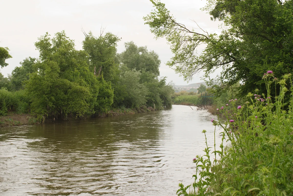
A river runs between dense green trees, with purple-flowered plants on the near bank and a pale overcast sky.

The Manzanares at Soto de las Juntas in May 2025, showing riverside habitat elsewhere in the regional park. This is not Caserío de Henares; the official Soto de las Juntas walk is currently suspended.

Soto de las Juntas - Parque Regional del Sureste - Madrid 03.jpg — Javier Perez Montes / Wikimedia Commons / CC BY-SA 4.0 International · Creative Commons 1 · Creative Commons 2

Walks and routes

Caserío: Entre Eneas y Tarays, a guided-visit example

The centre’s 11 October 2026 programme offered a low-difficulty circular riverside walk of 4 km, with 20 m cumulative elevation, lasting three hours. It was free, required phone booking and was advertised for children over six and adults. Use this as a guide to the kind of morning available, then ask which comparable activity is currently scheduled.

Low difficulty does not mean wheelchair suitability. Tell staff about mobility, pushchair and rest needs before reserving.


Caserío: Entre Eneas y Tarays, a guided-visit example

Las Islillas: lagoons and the Henares weir

This separate circular walk starts and finishes at Área Recreativa Las Islillas in Mejorada del Campo. The official sheet gives 2.8 km, about 1½ hours, low difficulty and 47 m ascent/descent. It links lagoon and river scenery with a bird observatory. Follow the official route information carefully at the many forks.

The circuit follows outdoor dirt paths beside river and lagoon margins. Ask about current surfaces and any barriers before choosing it for a wheelchair or pushchair; take particular care near the weir.

Las Islillas: lagoons and the Henares weir

Soto Bayona: the adapted riverside segment

At Titulcia, follow the designated segment from the parking area northwest of the town to the Jarama-side wildlife observatory. The official distance is 700 m each way: allow for 1.4 km in total when returning by the same path. Give yourself around 45–75 minutes for an unhurried outing, including a stop to watch the river. The published profile gives 1 m of ascent and descent on the adapted segment.

The operator describes this segment as adapted for motor, visual and intellectual disabilities, with reserved parking, two adapted picnic tables, an accessible hide, Braille and QR-linked audio information. The path is an outdoor surface; verify its condition and the facilities you need.

Soto Bayona: the adapted riverside segment

A short first visit: 1–2 hours

Check the centre is open, visit Descubre Caserío, and ask staff what can be visited that day. Keep the rest flexible rather than promising children access to a pond or hide without a booking. This is a good choice when time, energy or weather limits a longer outing.

A booked nature morning

Reserve the activity first and follow its meeting time, age conditions and equipment advice. Leave the whole morning available for a three-hour walk when that is the advertised duration. Add the exhibition only if opening hours and the programme allow, then finish without trying to drive between every wetland.

An independent riverside outing

Choose Las Islillas for the 2.8 km circuit, or Soto Bayona for the 700 m one-way adapted segment. Treat these as alternatives with separate starting points. Check the route notice and weather, take a simple snack, and allow extra time for observation and the return journey.

Things to try

Start with Descubre Caserío

The free permanent exhibition uses material from the estate and interpretation panels to introduce its ecosystems. Visit during the centre’s opening hours; it is a useful way to choose what to look for outdoors.

Join an organized wildlife visit

Ask for an activity that includes the Cerro Gordo wetlands or amphibian pond. Arrange permission and meeting instructions with the centre before travelling. Let the educator set the pace and keep the group together.

Try a seasonal growing workshop

Caserío’s programme includes organic-gardening activities. The October 2026 offer includes a compost workshop; other dates and themes change. Book the session rather than entering allotments or collecting produce on your own. Treat the growing beds as cultivated spaces.

Give children one small thing to notice

At the exhibition, choose a habitat to look for later. During an authorized outdoor visit, compare open water with the vegetation at its edge, or watch a diving bird until it resurfaces. A notebook or a quiet sketch can be more absorbing than trying to name every animal.

Photograph the habitat from the path

Frame the meeting of water, reeds and river trees, or wait for a bird to enter the view. Use distance and patience rather than approaching wildlife. Keep the path clear, and check with the educator before bringing bulky photographic equipment to a group activity.

Keep the plan at the centre

If river paths are wet or a weather warning makes an outdoor visit unwise, ask whether Descubre Caserío or a scheduled indoor workshop is available. The exhibition follows centre opening hours. Do not travel through flooding to reach it, and do not use closed El Campillo as your indoor fallback.

Wildlife and habitats

Grey heron

Watch the water’s edge for a patient, long-legged bird; observe from the permitted path or hide.

Little grebe

Follow a small diving bird across the open water and see where it resurfaces.

White stork

Look across open wetland views for the strong black-and-white shape, without approaching nests.

European bee-eater

A summer visitor in the official sheets. Watch for colour and fast flight from the authorized route, keeping well away from nesting banks.

Western marsh harrier

Scan above the reeds for a raptor moving low over the wetland; give it plenty of space.

Iberian green frog

During a booked pond visit, look quietly along the water margin and listen when staff suggest. Do not catch or handle animals.

Iberian ribbed newt

This species appears on the official pond sheet. Ask the educator how to observe responsibly, leaving vegetation and shelter undisturbed.

White poplar

Notice the contrast between the upper and pale undersides of leaves from the path. White poplar is included in the park’s flora guide.

Common reed

Look at the tall reed stands as habitat in their own right. Watch from outside the vegetation rather than pushing through it.

Stories and discoveries

Some wetlands began as workings

The Cerro Gordo lagoons occupy former extraction pits on an abandoned river meander. Their present wildlife interest is a good reminder that restored and human-altered places can be important habitats.

The allotments predate the regional park

Caserío’s leisure allotments have been operating since 1987; the regional park was designated in 1994. The centre links cultivation with environmental learning today.

A pond and a lagoon serve different lives

Caserío’s amphibian pond was specifically created as habitat for amphibians. The much larger former gravel-pit lagoons offer a different setting for waterbirds. Both are part of the centre’s organized wildlife visits.

When to visit

Spring

Book a wetland activity and allow time to watch changes in the river vegetation. Migration adds interest at Cerro Gordo. Give nesting wildlife space and keep to the educator’s route.

Summer

Choose shorter outings and avoid hot, exposed hours. The Las Islillas and Soto Bayona route sheets recommend other seasons for walking. A scheduled centre activity may be a better fit, but check its start time and bring water rather than assuming a shaded route.

Autumn

Cerro Gordo’s official information highlights autumn migration. Combine a booked visit with the exhibition, or select a seasonal growing workshop. After rain, ask about mud and bank conditions before setting off.

Winter

Wetland watching can still be worthwhile, and Cerro Gordo’s sheet highlights winter. Dress for standing still, leave enough daylight for the return, and confirm holiday opening days. Do not enter flooded or closed paths to reach a hide.

Getting there and practical advice

Caserío: opening hours and contact

Camino de la Vega, s/n, 28830 San Fernando de Henares. Phone +34 91 673 82 99. Published hours: Tuesday–Friday 10:00–15:00; weekends and public holidays 10:00–18:00. Closed on non-holiday Mondays and 1 and 6 January and 24, 25 and 31 December. Confirm before travelling.

Exhibition and activity costs

Descubre Caserío is free. The checked October 2026 guided walk and workshops are also advertised as free, with phone reservations required for the organized activities. Availability, age limits and conditions belong to each dated programme; confirm your particular booking.

Toilets, parking and a place to pause

Caserío lists adapted toilets and a ground-floor social room. Its paved parking has small level changes and is described as practicable, but has no reserved disabled parking space in the published assessment. Ask staff about the best arrival and drop-off arrangements.

Pond and wetland access

The amphibian pond and Cerro Gordo birdwatching points are reached as part of organized activities. Their appearance in the observatory network is not permission for independent entry. Check with the centre before arriving specifically for one of these features.

Food and drinking water

Bring your own drinking water and a snack rather than depending on an on-site café or refill point. Ask staff where eating is appropriate, use designated recreation areas, and leave cultivated plots alone.

By car to Caserío

Use the full centre name and Camino de la Vega in San Fernando de Henares as your destination. Official directions approach via the M-206/Torrejón de Ardoz, past the Las Monjas industrial area, then follow signs for the environmental-education centre and agricultural school. Allow time for the final approach rather than navigating to a generic park pin.

By train, then an onward connection

Torrejón de Ardoz is the station named in Caserío’s official directions. CRTM lists Cercanías C-2, C-7 and C-8 there. Use Renfe’s journey planner for your date, then arrange the onward journey to the centre separately. Ask staff about a suitable pedestrian approach or arrange a taxi, leaving enough time for that final stretch.

Choose the right part of the park

Las Islillas starts in Mejorada del Campo; Soto Bayona starts northwest of Titulcia. These are separate destinations from Caserío. Rivas-Vaciamadrid’s Metro access serves another part of the regional park and does not put you at Caserío’s entrance. Plan the return trip as carefully as the outward journey.

Caserío buildings and parking

The published assessment identifies adapted toilets and a ground-floor social room with wheelchair-width doors. Parking is paved and described as practicable, with slight changes in level and no reserved disabled space. Confirm access to the exhibition and any other room needed for your chosen activity.

Caserío paths and organized visits

Estate paths are broad sand and compacted aggregate but have irregularities and lack support rails or resting benches. Some individual spaces are listed as accessible, including the amphibian pond and Cigüeña observatory; access to the pond still requires an organized activity. Ask for advice on your exact route, chair or pushchair and rest needs.

Soto Bayona adapted segment

The 700 m one-way segment is specifically described as adapted, with reserved parking, two adapted picnic tables, a hide usable seated or standing, Braille and audio-linked interpretation. Return along the same path. Ask about maintenance and any barrier changes; do not extend this claim to the full cliff walk.

Las Islillas circuit

The circuit includes dirt paths and riverside areas with a damaged-weir warning. Ask about firm surfaces, slopes and current barriers before choosing it for a wheelchair or pushchair, and be prepared to shorten the outing.

Visitor information

El Campillo: centre, grounds and access road closed

The official notice checked on 17 October 2026 continues to report closure after the March 2025 flood. Some education activities take place at other venues or on modified routes. Do not mistake these events for reopening of the centre or its approach road.

Soto de Las Juntas: official walk suspended

The official walking-route page carries a temporary-suspension notice. Do not plan that loop until reopening is confirmed, even though measurements and route descriptions remain visible on the page.

Sources and useful links

Wildlife you might spot

9

Each card links to a full Explore page with photos, traits, and fun facts.

Snap map for this place

Start with the big picture, then zoom in to explore individual wildlife observations around this place.

Loading map…

Good to know before you go

Book Caserío’s guided visits by phone on +34 91 673 82 99. Ask about the route, minimum age, access arrangements and weather before setting out.

Check the closure notices first. El Campillo’s centre, parcel and access road are closed, and the official Soto de Las Juntas route is suspended.

Bring drinking water, a snack, sun protection, footwear with grip and binoculars if you have them. Do not rely on finding refreshments beside a lagoon.

Keep children close by ponds, rivers and muddy banks. At Las Islillas, give the damaged Henares weir a wide berth; never step onto it or enter floodwater.

Stay on authorized paths and respect gates and private plots. The protected wetland areas at Caserío are not a shortcut between public walks.

Watch wildlife quietly from the permitted path or hide. Avoid nest approaches, feeding, call playback and handling pond animals; leave plants and natural objects in place.

Ask before bringing a dog to a booked activity or into a restricted area. Where dogs are permitted, keep yours on a lead and away from wildlife and other visitors.

Take litter home, do not light fires, and do not swim in or drink from the lagoons. Follow staff instructions and temporary barriers; call 112 in an emergency.

Frequently asked questions

Make Caserío de Henares your base, at Camino de la Vega, s/n, San Fernando de Henares. The free exhibition is the straightforward starting point. Book a guided activity if you want access to the protected wetlands or amphibian pond.
The official observatory sheets describe access through organized activities. Arrange your visit with Caserío rather than assuming the hides or pond can be reached independently. Follow the route and access instructions provided for your booking.
The permanent Descubre Caserío exhibition is free. The recent guided walk and the October 2026 workshops checked for this guide are also listed as free, with advance phone booking. Confirm the charge and conditions of your chosen activity; separate recreation businesses elsewhere in the park may have their own fees.
The published public hours are Tuesday–Friday 10:00–15:00 and Saturdays, Sundays and public holidays 10:00–18:00. It closes on non-holiday Mondays and on 1 and 6 January and 24, 25 and 31 December. Confirm holiday arrangements before travelling.
The official notice checked on 17 October 2026 still says that the centre, surrounding parcel and access road are closed after the March 2025 flooding. Its education team continues some activities elsewhere or on modified routes. An activity listing is therefore not proof that the building or its access road has reopened.
Its official route page currently carries a temporary-suspension notice. Leave that walk out of your plan until the park confirms reopening, even though the same page still displays route details.
Cercanías trains serve Torrejón de Ardoz, the station named in Caserío’s official directions. Plan the onward journey to Camino de la Vega separately and ask the centre about the appropriate approach. Do not assume the station is at the centre entrance.
Contact Caserío about the particular facilities and booked activity you want. For a separate riverside outing, Soto Bayona in Titulcia has a designated adapted segment, reserved parking and adapted picnic furniture. Ask about current surface and facility conditions before making the journey.
The wildlife suggestions are based on official records for the park and its visitor areas. What you see depends on season, conditions and chance. A quiet visit can be rewarding even when the birds stay hidden.

Recent snaps at this place

Recent snaps will appear here as new observations are added.

View all ›

Take the discovery with you

Exploring Parque Regional del Sureste?

Identify the wildlife you spot, learn as you go, and keep a collection of the adventure.

  1. 1Spot it
  2. 2Snap it
  3. 3Keep the discovery




