Snappit logo
Snappit
Get App
Generic illustration, not a photograph of this venueIllustration
ParkHauts-de-France, FR

Scarpe-Escaut Regional Nature Park

Scarpe-Escaut lies in the Nord department of Hauts-de-France, between the urban worlds of Lille, Douai and Valenciennes.

About

Scarpe-Escaut lies in the Nord department of Hauts-de-France, between the urban worlds of Lille, Douai and Valenciennes. Its appeal comes from the way villages, woodland, farmland and former industrial sites fit together. This is a lived-in regional nature park, with several possible starting points rather than one entrance and a single must-do trail.

Water gives the landscape its underlying structure. The Scarpe and Escaut valleys contain wet meadows, peatlands, marshes, alluvial woodland and lakes formed by mining subsidence. Their Ramsar recognition dates from 2020. These wetlands do practical work too: storing water, moderating floods and supporting the quality of the water supply. A ditch beside a field or a line of pollarded willows can be as revealing as a broad lake.

The forest of Raismes-Saint-Amand-Wallers is a good first chapter. Broad avenues, locally called drèves, make its managed character visible, while narrower paths bring you closer to the woodland floor. For a compact visit, choose the Circuit du Coucou. For open water and the strongest connection with coal mining, consider a separate visit to Mare à Goriaux. They are different outings; there is no need to connect them on foot to have a satisfying day. Turn your visit into a safari! Use the Snappit app to scan and log wildlife sightings here.

Created in 1968, Scarpe-Escaut was France’s first regional nature park. Its landscape already carried a long history: woodland estates and abbey lands, drainage and farming, then the enormous changes brought by coal extraction. The present forest combines three formerly separate forests, and much of its tree cover was rebuilt after the devastation of the First World War. Mining altered both the skyline and the ground beneath it. Spoil accumulated in terrils, while subsidence helped create new expanses of water. At Mare à Goriaux, falling ground reached below the water table and the lake expanded. The site became a managed biological reserve in 1982. Visiting today means reading industrial history and ecology together: the same changes that disrupted an older landscape also produced habitats now worth protecting.

What to do here

Walk a short signed forest circuit, look for the contrast between oak foliage and pale birch trunks, and connect the woods with the nearby mining heritage. At an open lake viewpoint, take binoculars and give a few waterbirds your attention rather than trying to identify everything at once.

Seasonal info

Before any forest walk, check the ONF hunting calendar for Raismes-Saint-Amand-Wallers and the notices at your chosen entrance. The calendar is indicative and can change. Choose another outing if the route crosses a signed active hunt or a closed working area.

Accessibility

The Coucou route is a short family walk on forest paths and drèves, not an audited step-free circuit. Roots, loose surfaces and wet ground can matter more than its modest length. For wheelchair or pushchair requirements, ask the tourism office about the exact current surface and any barriers before travelling.

Don't miss

1

The Circuit du Coucou

a manageable introduction to the forest

2

Mare à Goriaux

a lake created by mining subsidence

3

The contrast between dark mine spoil and returning vegetation

4

Arenberg’s headframes and the story behind the surrounding landscape

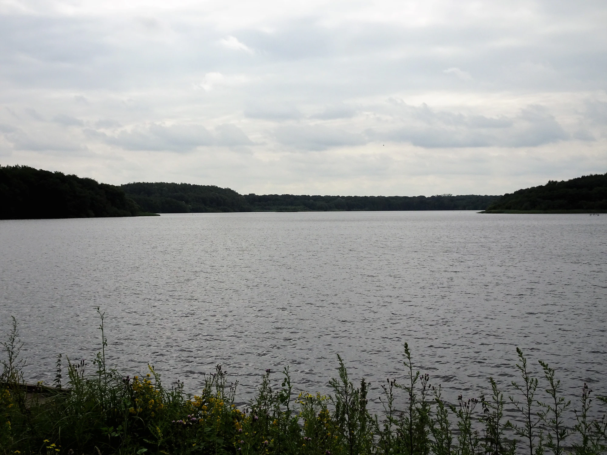
A broad lake beneath grey clouds, bordered by dark woodland and foreground plants.

The Mare à Goriaux at Raismes, photographed in July 2021.

Photograph: Pierre André LECLERCQ. CC BY-SA 2.0. Original image unchanged. · Creative Commons

Walks and routes

Circuit du Coucou: the short woodland choice

Start at 2 chaussée Brunehaut, Raismes, beside the landmarks named in the departmental sheet: the Auberge du Lièvre and Coucou mini-golf. Follow the yellow-marked Coucou circuit, keeping the downloaded map handy at forks. It uses the chaussée Brunehaut and a path parallel to the drève d’Escautpont before returning past a blockhouse. The Département du Nord gives 2.6 km and 50 minutes; the tourism listing gives 2.5 km. Allow 1–1½ hours with pauses.

This is the smaller forest option, with no terril climb in the published route. Natural surfaces may be muddy or uneven; its family rating does not certify wheelchair access. The named businesses are wayfinding landmarks, not a promise that they will be open.


Circuit du Coucou: the short woodland choice

A morning in the woods

Use the Circuit du Coucou as the whole outing: arrive with the sheet downloaded, read the entrance notices, then walk at a pace that allows a few stops. Finish while everyone still has energy. A short route is especially rewarding when the group is learning to distinguish trees.

Forest and industrial history

For a varied half-day, pair the woodland walk with a separately planned Arenberg visit. Leave time between the two for transport and lunch. On a full day, an accessible, currently open lake viewpoint can add the water story, but it need not become another long walk.

For a longer wetland day

La Canarderie at Condé-sur-l’Escaut is an alternative outing through the Chabaud-Latour landscape, rather than an extension of Coucou. The park lists 9 km and 2½–3 hours, with a yellow-marked route from the leisure-base car park. Use the modified official circuit: its notice of 26 February 2026 closes point 3.

Things to try

See the lake as a mining landscape

Mare à Goriaux is a separate destination reached from its named car park via the A23 Raismes exit. ONF has announced early-autumn restoration at the roselière d’Aubry, so confirm current path access before travelling. If an open path permits a lakeside stop, compare the water, woodland edge and terril as parts of one story.

Read the forest avenues

At a junction, look along the straight drèves and notice how deliberately the forest has been organised. ONF explains that star-shaped crossroads historically served hunting and forestry. Children can compare the broad avenue with a smaller signed path without leaving the route.

Put people back into the picture

At Wallers-Arenberg, the mine buildings and headframes give scale to the industry that shaped the park. The former extraction site now also supports image and digital-media work. A guided heritage visit adds the workers’ perspective; check available tours and book through the tourism office.

Rain is one thing; wind and storms are another

A light shower may simply mean a shorter outing in waterproofs, provided paths are safe. Strong wind or thunderstorms are reasons to postpone the forest visit. Check Météo-France vigilance for Nord, and never step around a barrier or through floodwater to salvage a planned loop.

A heritage option with a booking

If the weather makes woodland unsuitable, ask about an Arenberg guided visit that includes indoor spaces such as the lampisterie or former changing rooms. Availability and the amount of time outside vary by tour. Secure a suitable booking before treating it as a rain plan.

Wildlife and habitats

Great crested grebe

A good bird to watch patiently on the lake. Look for a long neck and pointed bill, then follow one individual through a dive and its return to the surface. Keep the binoculars trained on a broad area rather than approaching the bank for a closer view.

Common reed

The reed fringe gives the lake a different texture from the wooded shore. Its tall stems create habitat that can conceal birds very effectively. Look into the edge from an open public viewpoint; pushing through reeds would damage precisely the cover you came to enjoy.

Birches

Pale birch trunks stand out against dark spoil around the mining landscape. Look for the contrast between light bark and small leaves. Recognising the birch group is a useful starting point; you do not need to identify every tree to species.

Pedunculate oak

The forest leaflet identifies pedunculate oak as a major component of the woods. Compare its broad, lobed leaves with the smaller birch leaves where both are visible from the path. There is no need to collect leaves or acorns to enjoy the contrast.

Stories and discoveries

One forest, three names

Raismes, Saint-Amand and Wallers were separate forests before being brought together. Their joined name preserves that history. The present tree cover is also a record of rebuilding after war, rather than evidence of an untouched primeval forest.

Protection means active care

The Mare à Goriaux reserve is a managed biological reserve, established on 16 February 1982. In such a landscape, conservation can involve intervening in water edges and vegetation. The Aubry reedbed project shows why visitor access and habitat work sometimes have to change together.

A wetland is more than a lake

The Ramsar landscape includes grazed meadows, channels and peat-related habitats as well as conspicuous open water. Its ecological value comes from this mixture. Looking across a field boundary can reveal a different part of the park from the one visible at a birdwatching viewpoint.

When to visit

Spring and summer

In the woodland, notice changing leaf cover and the patches of light reaching the ground. Around wetlands, stay well back from nesting cover and avoid recorded bird calls. Choose the cooler part of a warm day, take water and leave room in the plan for a shorter visit.

Autumn and winter

Fallen leaves and wet ground change the footing, while the open lake can feel markedly colder than a sheltered drève. Allow for the shorter day and check the hunting information before choosing a forest sector. Binoculars and a warm layer often matter more than an ambitious distance.

Getting there and practical advice

Information before you arrive

The Office de Tourisme de La Porte du Hainaut can help with current trail access, guided visits and suitable alternatives: +33 (0)3 27 48 39 65. Its listed address is 35 avenue Michel Rondet, Plot F, Wallers-Arenberg. Confirm reception hours if you plan to call in.

Plan essentials independently

Carry what you need for the walk and use facilities in town before leaving. Neither the forest route description nor the lake listing should be taken as a guarantee of an open toilet, accessible toilet, café or drinking-water point at the start. Check any essential requirement directly.

Choose the trailhead, not just the park name

For Coucou, use the individual departmental route sheet and its Raismes departure. For Mare à Goriaux, use the named lake car park. These are separate starts within a large forest landscape. Park only where permitted, keeping forestry gates and access tracks clear.

Arriving without a car

Saint-Amand-les-Eaux has a TER station and is a useful gateway, but arriving there is not the same as arriving at the forest trailhead. Use the Transvilles journey planner for the onward and return journeys, checking the actual walking connection to the route. Do not assume a direct lake bus or a convenient Sunday service.

Match the walk to the group

If a child is only beginning to walk independently, or anyone needs frequent rests, agree a turnaround point before leaving the start. A shorter out-and-back on the same permitted path is preferable to struggling through a complete circuit. Keep children close at roads, ditches and water edges.

Ask about the actual surface

For mobility planning, ask about gradients, clear widths, bollards, recent mud and the distance from parking to the first useful stopping place. A short distance and an easy walking grade do not answer those questions. Do not rely on proposed new pontoons or a belvedere until their completion and access are confirmed.

Sources and useful links

Wildlife you might spot

4

Each card links to a full Explore page with photos, traits, and fun facts.

Snap map for this place

Start with the big picture, then zoom in to explore individual wildlife observations around this place.

Loading map…

Good to know before you go

Download the route sheet before setting off and follow newer on-site diversions if they differ from it.

Bring water and a snack; do not plan your walk around finding a café or drinking-water tap at the trailhead.

Use binoculars from the path, leaving room for other visitors to pass.

Wear footwear with grip, particularly after rain, and check for ticks after time in the woods.

Keep dogs on a lead for these outings and respect any stricter local restrictions.

Do not enter old blockhouses, mine structures or fenced restoration areas.

Frequently asked questions

No single gate controls this inhabited territory. Choose a particular public route or visitor site. Guided visits, activity centres and heritage buildings have their own booking arrangements and charges.
Do not assume that a lake circuit is available on the day. The promoted route includes the drève d’Aubry and terril sector, where restoration works have been announced. Check the current route with the tourism office and obey all barriers; there is no suggested off-path bypass.
This guide covers the French Parc naturel régional Scarpe-Escaut. It cooperates with Belgium’s Parc naturel des Plaines de l’Escaut, but that neighbouring park is a separate place with its own visitor information.
Plan Mare à Goriaux as a land-based nature visit. A path beside water does not establish swimming or launch access. For water activities, use a specifically authorised operator and site.

Recent snaps at this place

Recent snaps will appear here as new observations are added.

View all ›

Take the discovery with you

Exploring Scarpe-Escaut Regional Nature Park?

Identify the wildlife you spot, learn as you go, and keep a collection of the adventure.

  1. 1Spot it
  2. 2Snap it
  3. 3Keep the discovery