Snappit logo
Snappit
Get App
Generic illustration, not a photograph of this venueIllustration
ParkCastilla-La Mancha, Spain

Tablas de Daimiel National Park

Give Las Tablas time to reveal itself.

About

Give Las Tablas time to reveal itself. A ripple beside the reeds, a bird crossing the sky or the shape of an island can hold your attention longer than you expect. Start at the visitor centre and make Isla del Pan the main outing, leaving room to pause rather than trying to cover every path.

This is a floodplain wetland in the broad, flat landscape of La Mancha. The Guadiana and Gigüela meet here, and groundwater is part of the story too. The shallow flooded areas known as tablas depend on a water system extending well beyond what you can see from a boardwalk.

Come with flexible expectations. Water can spread across the wetland or retreat dramatically, changing both the view and the places birds use. A dry-looking visit can still be rewarding if you enjoy plants, geology and the conservation story, but ask about the water before making a special journey for open-water birdwatching. Take the ultimate field guide with you: use the Snappit app to identify birds, plants, and animals on your trip.

Las Tablas became a national park in 1973, during a struggle to protect the wetland from drainage and the effects of increasing groundwater extraction. National-park status did not remove its dependence on the surrounding water system. That tension is central to understanding the place. The park was reclassified in 1980 and enlarged in 2014. The wider La Mancha Húmeda landscape became a biosphere reserve in 1981, and Las Tablas gained Ramsar wetland recognition in 1982. Nearby Molemocho, a former watermill, adds a human scale to the story: people have long used and altered the water that gives this landscape its character.

What to do here

Begin with the visitor-centre displays, then follow the signed Isla del Pan itinerary at an unhurried pace. Choose one quiet viewing stop and one plant to learn. If you have more time, ask whether Laguna Permanente or Prado Ancho would add something different that day.

Seasonal info

The season alone will not tell you how much water there is. Summer commonly brings falling levels and intense heat; winter can be cold and foggy. Rainfall, river inflows, groundwater and management all affect the wetland. In a report dated 2 October 2026, Daimiel’s council described two wet hydrological years alongside continued groundwater decline. Ask the park about the conditions for your visit rather than treating a rainy year or an old photograph as a promise of flooded boardwalk views.

Accessibility

There are adapted visitor options, but choose the particular path and viewing point with staff. Isla del Pan combines boardwalks and earth surfaces, and not every hide on the other routes offers step-free access. Before travelling with a wheelchair or pushchair, ask about the recommended circuit, boardwalk condition, parking and the adapted toilet at the visitor centre.

Don't miss

1

Follow the island-and-boardwalk landscape around Isla del Pan.

2

Learn how rivers and groundwater support an inland wetland.

3

Compare reeds, masiega and tamarisk instead of treating the vegetation as a backdrop.

4

Spend an unhurried spell watching from a permitted viewing point.

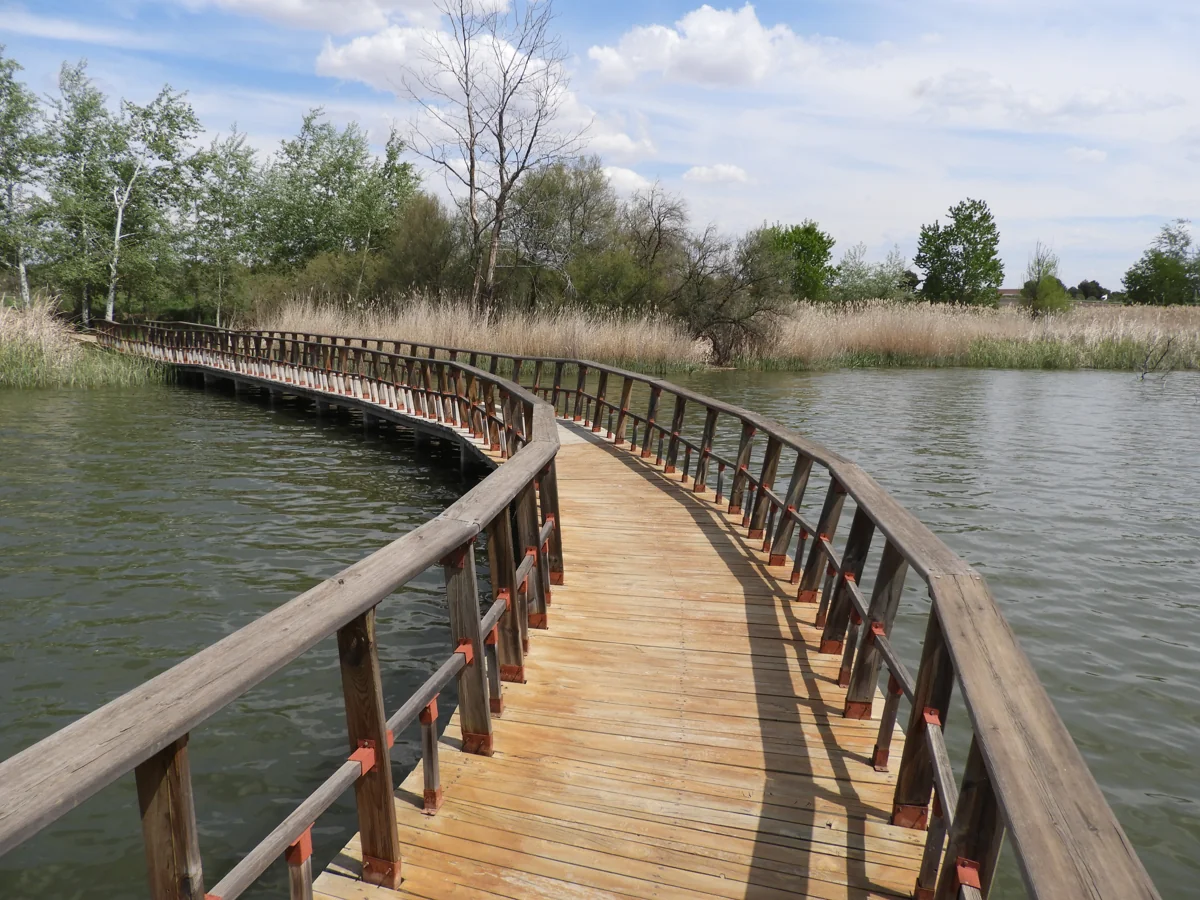
A curved wooden boardwalk with railings crosses open water towards reeds and trees.

A boardwalk across water in Tablas de Daimiel, photographed in April 2017. Water levels and the condition of walkways change, so check the current visitor information.

Pasarela en el Parque.jpg — Quijotemancha / Wikimedia Commons / CC BY-SA 4.0 · Creative Commons

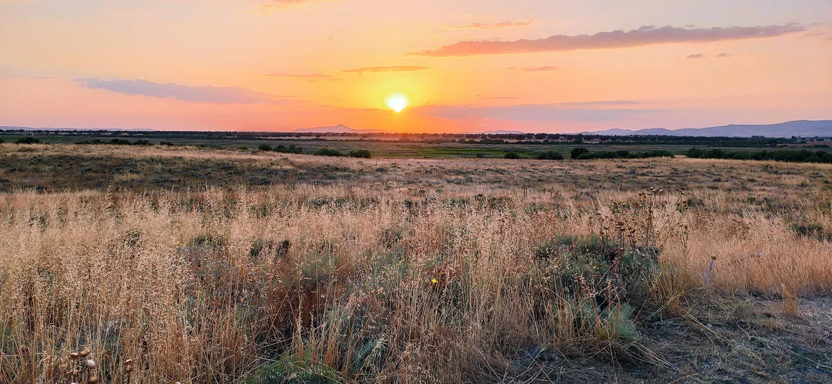
Low sunlight falls across a wide dry grassland, with distant low hills beneath pink and orange clouds.

Sunset at Isla del Pan in July 2020, with dry grasses across the foreground. The scene reflects conditions on that date.

Reserva Biosfera La Mancha Húmeda.jpg — Gormhonk / Wikimedia Commons / CC BY-SA 4.0 · Creative Commons

Walks and routes

Isla del Pan: the first-visit choice

The MITECO route page describes a circular 2 km itinerary, taking 1–1.5 hours, across five islands linked by wooden walkways. Give yourself longer if you like to stop. The appeal is the changing relationship between islands, vegetation and the water or exposed ground around them. Official descriptions differ: the longer park guide gives 2.5 km and CNIG gives 2.7 km. Ask staff which signed circuit is available, and follow that circuit rather than trying to match a distance on your phone.

Ask staff to identify the suitable boardwalk-and-earth-surface option for your wheelchair or pushchair. Do not assume every branch of the published loop has the same access conditions.


Isla del Pan: the first-visit choice

Laguna Permanente: a quieter observation outing

MITECO lists 800 m for this linear route and a little over an hour; CNIG lists a 1.7 km return itinerary. Check the turnaround and total distance with staff. Choose it for patient observation from the lagoon’s hides and a change from the island circuit. Leave time to come back, and let the actual water conditions guide whether it is worth adding that day.

Published accessibility guidance flags steps at the first observation hide. Ask about the suitable approach and alternative viewing point.

Laguna Permanente: a quieter observation outing

Prado Ancho: a wider wetland view

This route follows the wetland edge towards a raised observation point, with intermediate hides along the way. MITECO lists 1.5 km and about two hours for the linear itinerary; CNIG describes 3.3 km out and back. Treat it as a separate, longer choice and confirm the return distance before leaving. It suits visitors who want to spend time scanning the wider landscape rather than add another loop in a hurry.

Published accessibility guidance excludes the final observation point from its accessible-route description. Ask which ground-level views and sections suit your needs.

Prado Ancho: a wider wetland view

A relaxed first morning

Start with the visitor centre when it is open and ask about water, paths and access. Spend around half an hour with the displays, then take the staff-recommended Isla del Pan circuit with plenty of pauses. Finish when the group still has energy. Allow 2–3 hours overall, with lunch planned outside the park.

For keen observers

Choose Isla del Pan or one of the two other routes according to that day’s conditions. Spend more time at fewer stops, with binoculars and a field guide. A half-day allowance leaves room for the centre and an unhurried return; you do not need to complete all three paths to have a good visit.

Things to try

Try a five-minute watch

Choose a viewing place without blocking the path. First look at the whole scene, then search one small patch slowly. Notice whether birds are swimming, diving or moving through vegetation. A sketch or a note about behaviour is useful even when you cannot name the species.

Read the wetland in layers

From the path, compare open water or exposed ground, dense emergent vegetation and the trees on the islands. Ask how that arrangement might change with a higher water level. Children can draw the same view using just three shapes.

Make a quiet sound list

Stop talking for a minute and listen for wind in the vegetation, bird calls and human sounds. Record a few words about what you hear rather than playing calls back to attract birds. Keep the exercise brief and leave space for other visitors.

Add the watermill story

If Molemocho is open, its interpretation offers another way into the wetland: how people used water and lived beside it. Check the separate opening or booking arrangements before building it into your day.

Let the centre lead the visit

If rain, strong wind or poor visibility makes the boardwalk outing unappealing, spend more time with the visitor-centre interpretation, subject to opening. Molemocho may be another option if its separate visiting arrangements suit. Postpone the walk if conditions are unsafe instead of treating a hide as a guaranteed shelter.

Wildlife and habitats

Eurasian coot

Look for an adult’s dark body and white bill and forehead shield. Watch from a hide or path where water meets vegetation, and compare its shape with nearby ducks.

Red-crested pochard

The adult male’s reddish head and bright red bill are useful features to learn; females are browner and less conspicuous. Use binoculars over open water rather than approaching birds for a photograph.

Great crested grebe

Include the open-water birds in your watch as well as those near the reeds. Notice diving and resurfacing behaviour, and use a field guide to check the identification.

Western marsh harrier

Lift your gaze above the reedbeds as well as looking at the water. The park describes this raptor hunting over wetland vegetation. Watch from a distance without trying to locate a nest.

Common reed

Reed stands help make the wetland’s layered outline. Compare their appearance with the sedges using the interpretation material, and leave stems and leaves where they grow.

Great fen-sedge (masiega)

Ask staff to point out masiega from a permitted viewing spot. Its grey-green leaves have serrated edges, so learn it by looking rather than handling or collecting it.

Tamarisks

Notice the branching trees and shrubs around the islands. The park describes tamarisk along these margins; this prompt is for the genus, so it does not ask you to decide which tamarisk species you have found.

The plants and birds below are documented for the park, but what you find depends on water, season and chance. Watch quietly from permitted paths and hides, without feeding, call playback or searching for nests. Ask staff to distinguish any managed collection from wild birds before recording observations.

Stories and discoveries

The islands have a rocky foundation

The islands are not floating rafts of vegetation. Geological descriptions identify limestone outcrops rising from the wetland basin. Look for the contrast between those firmer islands and the surrounding low ground without leaving the path.

Water below ground matters too

Rain falling on the visible wetland is only part of the supply story. Groundwater and river flows connect Las Tablas to a much wider landscape, which helps explain why protecting its boundary alone cannot solve every water problem.

Masiega deserves a second look

The dense stands known locally as masegares are made by masiega, Cladium mariscus. Learning that one plant gives you a more precise way to describe the wetland than calling every tall waterside plant a reed.

When to visit

Spring

Look for fresh vegetation and breeding-season bird activity from the paths. Give birds space and resist following them into the reeds. Water availability still matters, even in the season most associated with a green wetland.

Summer

Choose cooler hours, carry water and keep the plan modest in strong heat. Levels often fall, mosquitoes can be bothersome and summer storms can change a visit. A shorter walk and the centre may suit the day better than several exposed routes.

Autumn and winter

Migration and wintering waterbirds give a reason to visit when suitable water remains. Bring warm layers, allow for fog and shorter daylight, and judge the outing by the conditions rather than a seasonal species checklist.

Getting there and practical advice

Visitor centre

The centre has interpretation displays and audiovisual material explaining the wetland and its water system. Telephone +34 926 693 118 for current opening, path conditions and access questions. Published summer and winter hours are broad guidance, so confirm the timetable for your date.

Parking and toilets

Published accessibility guidance records parking beside the visitor centre and an adapted toilet inside it. Check availability and opening before travelling if you depend on those facilities. Do not assume that a toilet will be available along every walking route.

Laguna de Aclimatación

The park guide describes an artificial lagoon used for interpreting waterbirds held in captivity. If staff confirm it is available to visit, use it to learn about identification while keeping collection birds separate from observations of wild birds. Its operation and access need checking independently of the walking trails.

Food and water

Bring drinking water and make a separate plan for your meal. The park leaflet prohibits picnicking inside the park; ask staff where eating is permitted before unpacking a meal. Keep food away from wildlife.

Arrive via Daimiel

Follow the signed road from Daimiel to the national-park visitor centre, roughly 10–11 km from town in the official descriptions. The administrative office in Daimiel is a different destination. If someone is driving you, agree the visitor-centre pickup point and time.

Plan the last leg

If you are coming without a car, arrange the journey from town to the park and back before travelling. Ask the tourist office or park about current transport options; do not make the day depend on an unconfirmed scheduled bus to the trailhead.

Choose a specific circuit

Discuss the route with staff before leaving the centre, including any changes around the island paths. Tell them whether you need a continuous step-free route, a short turnaround or places to rest. Boardwalks and compacted earth behave differently after rain.

Check individual hides

The published Imserso guidance identifies a staircase at the first Laguna Permanente hide and excludes the final Prado Ancho observation point from its accessible description. Ask which alternative views are suitable and whether those arrangements have changed.

Include arrival and facilities

Confirm suitable parking, the path from the car to the centre, toilet access and the opening hours you will rely on. A shorter visit with the right facilities can be a better choice than committing to a complete loop.

Sources and useful links

Wildlife you might spot

7

Each card links to a full Explore page with photos, traits, and fun facts.

Snap map for this place

Start with the big picture, then zoom in to explore individual wildlife observations around this place.

Loading map…

Good to know before you go

Ask the visitor centre about water levels, open paths and that day’s suitable viewing points before choosing your route.

Bring binoculars if you have them. Wait quietly, keep your distance and leave wildlife plenty of space.

Carry drinking water, sun protection and shoes with grip. In hot weather shorten the outing; in winter bring warm layers, and expect damp or slippery surfaces after rain.

Stay on the signed paths and keep children close on boardwalks. Do not enter exposed wetland ground just because it looks dry.

Pets and bicycles are not permitted inside the park. If you travel with an assistance dog, discuss access arrangements with the park beforehand.

Do not collect plants, disturb animals, swim, light fires or camp. Take litter away and plan your picnic outside the park.

Use the current signs and staff advice where route lengths differ between publications. Leave enough time for the return on linear routes.

Check centre and Molemocho opening separately. For a guided activity, confirm its meeting point and reservation requirements; call 112 in an emergency.

Frequently asked questions

The municipality describes the ordinary walking visit as free and open to independent visitors. Guided activities and visits to Molemocho have their own arrangements. Check the official reservation page or contact the visitor centre before relying on a particular session.
It depends on conditions. Ask about the flooded areas shortly before travelling. Neither the April 2017 boardwalk photograph nor the dry July 2020 Isla del Pan scene shows what you will necessarily find today.
Isla del Pan is the natural first choice for the island landscape. MITECO’s route page lists a 2 km circular walk and 1–1.5 hours, but other official publications describe longer versions. Confirm the signed circuit on arrival and allow extra time for stops.
Yes, if they enjoy looking and listening and can stay close to you on boardwalks. Keep the plan short enough for their energy and the weather. Try spotting three different habitats rather than promising a particular bird.
Ask staff for a suitable route before committing to the whole circuit. Published guidance describes adapted surfaces and facilities, but some observation points have steps and the condition of boardwalks matters. Confirm the toilet and parking arrangements too.
The park’s published guide describes this artificial lagoon as an interpretive collection of ducks in captivity. Ask staff what is currently there and how it is managed. Keep any collection observations separate from wild birds seen elsewhere in the wetland.
No. Laguna Permanente is a separate signed visitor itinerary with observation points. Its name is not a guarantee of a particular water level on the day. Laguna de Aclimatación is the interpretive facility described in the park guide.
Pets and bicycles are prohibited inside the park. Contact the park in advance about assistance-dog arrangements; do not assume ordinary pet rules describe that situation.

Recent snaps at this place

Recent snaps will appear here as new observations are added.

View all ›

Take the discovery with you

Exploring Tablas de Daimiel National Park?

Identify the wildlife you spot, learn as you go, and keep a collection of the adventure.

  1. 1Spot it
  2. 2Snap it
  3. 3Keep the discovery