
Snappit logo
Snappit
Get App
Generic illustration, not a photograph of this venueIllustration
ParkMainland, Spain

Sierra de las Nieves National Park

Sierra de las Nieves brings an unexpectedly mountainous side of Málaga into view.

About

Sierra de las Nieves brings an unexpectedly mountainous side of Málaga into view. Behind the coast are pale limestone ridges, deep folds in the hills and forests of pinsapo, the Spanish fir. These are mountains with their own weather and a long human story, from grazing and forestry to the work of storing winter snow for summer use.

For a first visit, keep the plan small: head for Los Quejigales when the access track is open and suitable for your vehicle. Settle into the recreation area, look towards the wooded slopes and give yourself time to notice the change from planted pine woodland to the mountain habitats beyond. A picnic and some quiet looking can be enough. If everyone is comfortable on uneven ground, you can consider a short out-and-back on the beginning of the signed Quejigales–Torrecilla trail.

That last name matters. Torrecilla is a mountain objective, not the natural end of a gentle family stroll. You do not need to reach it, Puerto de los Pilones or the high oak woodland to have a worthwhile day here. Decide before walking how much time and energy you want to spend, and turn back while you still have plenty of both. Planning to visit? Download the Snappit app to identify the wildlife you spot in real-time.

The mountains’ name carries the memory of a working landscape. Snow was packed into stone-lined pits, insulated with vegetation and kept for summer. Blocks of ice then travelled down to towns on pack animals. It was hard, seasonal work, and the surviving snow pits belong to the higher mountain landscape rather than an easy circuit around the picnic tables. Protection also developed over many decades. The area became a natural park in 1989 and gained UNESCO biosphere-reserve recognition in 1995. National-park designation followed in 2021. These overlapping histories explain why older trail leaflets still say ‘Parque Natural’ and why today’s national park, surrounding buffer zone and wider biosphere reserve should not be treated as identical places.

What to do here

Make Los Quejigales your base for a picnic, landscape watching and a little forest interpretation. Add only as much of the signed mountain trail as suits your group; keep the full Torrecilla ascent for a separate, well-prepared outing.

Seasonal info

Heat and fire restrictions can alter summer access; rain, fog, snow or ice can make the mountain approach and paths unsuitable at other times. Check the current notices and ask about the track before setting out. A date on an old seasonal calendar does not establish that a gate has reopened.

Accessibility

The official Los Quejigales listing describes a concrete ramp to one picnic table. Ask about the parking-to-table surface, ramp and toilets for your needs before travelling. Plan the mountain paths separately: they are stony and steep in places.

Don't miss

1

Take in the mountain setting from Los Quejigales without committing to a summit.

2

Learn why the pinsapo is such an important tree in southern Spain.

3

Compare pine woodland, dark fir-covered slopes and pale limestone.

4

Discover the story behind the mountains’ old snow-storage trade.

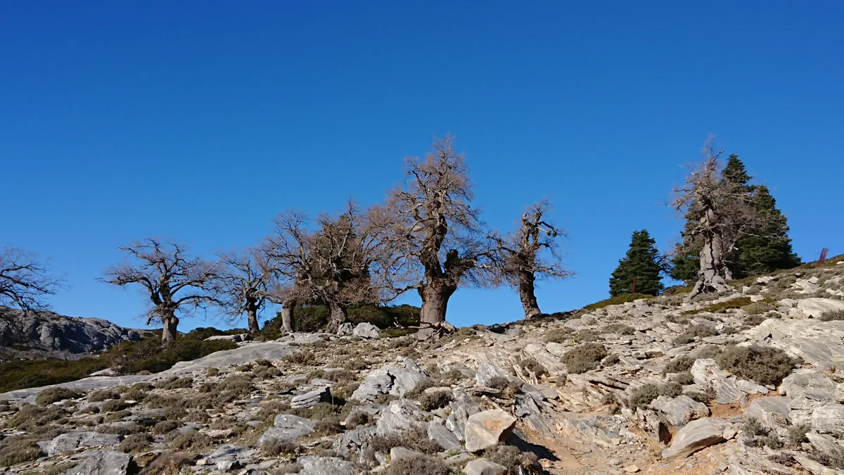
Gnarled leafless trees rise from a pale rocky slope beneath a deep blue sky.

Bare oaks on rocky ground in the Quejigales area of Sierra de las Nieves, photographed in December 2019. This is wider mountain context rather than a view of the recreation-area facilities.

Quejigos en Quejigales.jpg — Frandos2 / Wikimedia Commons / CC BY-SA 4.0 · Creative Commons

Walks and routes

Los Quejigales: keep it close to the picnic area

Make the recreation area itself the main destination. Choose a comfortable place to sit, look at the surrounding woodland and read any available information panels. Allow 45–90 minutes to settle in and enjoy the surroundings, with no required walking distance.

A concrete ramp serves one picnic table. Confirm the current route from parking and whether suitable toilets are available; ask staff which parts of the picnic ground will suit you.


Los Quejigales: keep it close to the picnic area

Optional: a little way along Quejigales–Torrecilla

Follow only the beginning of the official signed trail if you are comfortable on a stony uphill path. Set a turnaround time before leaving the recreation area and retrace your steps. A total walking budget of 30–60 minutes, including the return, is one way to keep the outing modest. Choose your own turnaround point according to conditions; this is not a separate signed short route.

The path is stony and climbs. It should not be treated as a wheelchair or pushchair route, and a short distance can still be tiring. Stay in the recreation area if uneven ground is a barrier.

Optional: a little way along Quejigales–Torrecilla

For another day: the full Torrecilla ascent

The official route is linear: 7.2 km and 3 hours 15 minutes outward, graded high difficulty. An out-and-back is about 14.4 km. Plan the return, breaks and any extra approach separately, and use the official leaflet and current park advice rather than this introductory guide as your route plan.

This is a demanding, stony mountain walk. The leaflet’s 634 m height difference is not a cumulative-ascent measurement. Expect uneven footing and sustained uphill walking.

For another day: the full Torrecilla ascent

A small mountain outing

Once access is confirmed, arrive with a picnic and take a few minutes to read the trail information before choosing your day. Spend time watching the slopes from the public-use area. If the weather, footing and everyone’s energy are right, walk a little way out on the signed trail and return the same way. Leave the afternoon flexible rather than setting a summit as your measure of success.

Things to try

Compare the forests

From a safe public place, compare the colour and outline of the nearby pines with the fir-covered slopes beyond. Try sketching two different tree shapes. The exercise works just as well without collecting a leaf or cone.

Have a quiet looking stop

Put the phone away for five minutes and listen. Then use binoculars to watch the tree line or an open patch of sky. Follow one movement patiently, and keep your feet in a safe place while you look.

Make a landscape notebook

Give everyone a page for three things: a tree shape, a rock texture and a sound. Add a question to look up later. A small, careful record is a good way to make a short outing feel full.

Keep a lower-level day in reserve

If heavy rain, strong wind or poor visibility makes the drive or walking doubtful, keep your day in Ronda or another town and return to the mountains in better weather. Do not count on Conejeras or an open building at Los Quejigales as a wet-weather refuge.

Wildlife and habitats

Spanish fir, or pinsapo

The tree to learn about before arriving. Abies pinsapo forms dark, dense woodland on cool, shaded mountain slopes. Look at the forest as a whole before trying to identify an individual tree; nearby picnic-area conifers are not automatically pinsapos.

Mountain oaks

The park’s high oak woodland grows well above the recreation area, around 1,600–1,800 m. Its old, sculptural trees are part of the wider mountain story. Do not expect that landscape beside the picnic tables.

Eurasian jay

Pause beside woodland and look for movement through the branches. If you see a bird, note its colours and shape before checking a guide. The park lists Eurasian jay among its wild birds.

Griffon vulture

Spend a little time looking above the ridges from a safe stopping place. A distant soaring bird is a chance to practise patient observation; binoculars and a bird guide help far more than chasing a closer view.

Golden eagle

Golden eagles are included in the park’s fauna. Treat this as a reason to learn the local raptors, rather than a checklist target for a short visit. Never seek out nests or leave the path to follow a bird.

Iberian ibex

The park’s cabra montés is adapted to rocky mountains. If you encounter one, give it space and keep dogs close. The official interpretation describes the rut in October–December; watch quietly from public places rather than seeking out animals.

Stories and discoveries

White mountains and darker rock

Limestone and dolomite create much of the pale, broken scenery, while peridotites contribute darker, often reddish landscapes elsewhere in the park. Different rocks help explain why one mountain slope can support a different plant community from another.

A fir forest in Mediterranean country

Pinsapos persist in particular mountain refuges in Málaga and Cádiz. In Sierra de las Nieves, shaded slopes help soften the hot, dry part of the year. Looking at aspect and shade is a useful way to understand why the forest is here.

The picnic-area woodland has a history

The pines around Los Quejigales were planted in the 1960s on former farmland. The recreation area is therefore a good place to notice a human-shaped forest before looking towards the older mountain habitats.

When to visit

Spring

Pick a settled day for woodland observation and an unhurried picnic. Carry layers, allow for wet ground and check the forecast before adding any uphill walking.

Summer

Check fire-related restrictions before planning the approach. Bring plenty of water and avoid treating the cool appearance of a forest as protection from heat. If the track is restricted or the day too hot, postpone the mountain outing.

Autumn and winter

Shorter daylight, fog and slippery ground change the pace of a visit. Snow and ice belong to a different level of mountain preparation. Choose a lower-level plan when the approach or paths are unsuitable, even if conditions in Ronda seem comfortable.

Getting there and practical advice

Picnic tables, parking and toilets

The official listing records tables, benches, parking and toilets at Los Quejigales. Check what is available before travelling, and bring a cold picnic and your own drinking water. Do not rely on a café, shop or open indoor refuge.

A useful call before you go

For road access, restrictions and facility questions, contact the park office on +34 670 948 894 or [email protected]. The directory address is an administrative office in Málaga, not a visitor reception at Los Quejigales.

Conejeras needs a separate check

As checked on 16 October 2026, the official notice still says Conejeras recreation area is closed for visitor-centre construction, a closure dated from 13 September 2024. A January 2026 update describes further work on the centre. Confirm an opening before planning to use either as a stop.

Keep the budget practical

Allow for transport, food and any booked guide or accommodation. Before arranging an organised visit, ask about current access or booking requirements and the operator’s price. No paid service is included in this self-directed plan.

The last part is a mountain track

Use the signed approach from the A-397 between Ronda and San Pedro de Alcántara. The official Los Quejigales directions describe roughly 10 km of access track, changing from surfaced to unpaved. Check its condition and the vehicle restrictions before committing; allow generous time and never drive around a barrier.

If you are travelling without a car

Ronda is the practical transport base mentioned in the official trail leaflet, but its regional bus and rail references do not establish a service to Los Quejigales. Arrange a return transfer or guided trip in advance and confirm exactly where it can take you. Do not assume a bus reaches the picnic area.

Ask about the whole chain of access

Discuss vehicle access, the parking surface, the route to the ramped picnic table and toilets together. An adaptation at one table may be helpful for your group, but it does not resolve every part of the visit. If a track barrier adds a long approach, the plan changes substantially.

Make the picnic a complete visit

For limited stamina or a pushchair, there is no need to add the mountain trail. Choose a comfortable outdoor stopping place with the park’s advice. A short section of a steep or stony route can be harder than a much longer paved walk.

Sources and useful links

Wildlife you might spot

5

Each card links to a full Explore page with photos, traits, and fun facts.

Snap map for this place

Start with the big picture, then zoom in to explore individual wildlife observations around this place.

Loading map…

Good to know before you go

Contact the park office on +34 670 948 894 before travelling to check Los Quejigales track access, restrictions and any facilities you need.

Bring your own drinking water, a picnic, sun protection and shoes with grip. The site’s water is listed as untreated; do not rely on it for drinking.

Pack a warm layer and waterproofs when the forecast calls for them. Conditions at this mountain site can differ sharply from the coast.

Use designated parking and respect gates, closures and private property. Do not turn a closed vehicle approach into an unplanned long walk.

Keep to signed paths. Give wildlife space, keep dogs on a lead, leave plants and rocks in place and take all litter away.

Bring a cold picnic rather than relying on barbecues. Do not light a fire or camp at the recreation area.

If you walk beyond the picnic area, carry the official route information offline, agree a turnaround time and leave enough energy and daylight for the descent.

Keep children close on stony ground and away from steep edges and holes in the limestone. In an emergency call 112; mobile coverage may be unreliable.

Frequently asked questions

It is a recreation area and trailhead. Do not plan around an indoor exhibition, café or staffed reception there. Ask the park office about currently available facilities before you go.
This visit does not depend on a named easy loop. The signed Quejigales–Torrecilla trail is a stony mountain route. You can choose a short out-and-back on its beginning if conditions and your group allow, or simply enjoy the recreation area.
The official leaflet gives 7.2 km and 3 hours 15 minutes for the outward journey, with high difficulty. Returning by the same route makes about 14.4 km, before any extra approach from a closed parking barrier. Treat it as a full mountain day, not an add-on to the picnic.
The published Quejigales–Torrecilla leaflet says no special authorisation is required for that named trail. Check current requirements with the park before walking, especially for organised activities. This does not override a closure or authorise driving past a locked gate.
Check toilet availability before travelling and bring all the drinking water you need. Use your own supply for drinking, and ask about the toilets if they are important to your group.
Not without checking first. On 16 October 2026, the official site still displayed a notice that Conejeras recreation area was closed for visitor-centre works. The new centre should not be counted on until the park confirms it has opened.
They are part of the park’s wildlife, but an encounter depends on place, season and luck. Watch quietly from public paths and enjoy the forest and mountain shapes too; never follow animals to get a closer photograph.

Recent snaps at this place

Recent snaps will appear here as new observations are added.

View all ›

Take the discovery with you

Exploring Sierra de las Nieves National Park?

Identify the wildlife you spot, learn as you go, and keep a collection of the adventure.

  1. 1Spot it
  2. 2Snap it
  3. 3Keep the discovery




