Snappit logo
Snappit
Get App
Generic illustration, not a photograph of this venueIllustration
ParkKyushu, Japan

Aso-Kuju National Park

At Chojabaru, you can enjoy the Kuju mountains while keeping your walk down at their feet.

About

At Chojabaru, you can enjoy the Kuju mountains while keeping your walk down at their feet. A wooden boardwalk runs into Tadewara wetland, where grasses, flowers and the changing mountain backdrop reward a slow pace. Start at Chojabaru Visitor Center in Oita Prefecture and choose a short circuit that suits your group. Aso-Kuju National Park also includes the Aso volcanic landscape in Kumamoto, but its crater is a separate destination with separate access controls.

Tadewara sits around 1,000 metres above sea level, with spring water from the surrounding mountains helping to feed the wetland. It is a patchwork rather than one uniform field: reed and moor-grass communities, sphagnum moss and neighbouring woodland respond to different conditions underfoot. The boardwalk lets you look into this living landscape without trampling it. Notice how plant height and texture change, and how a small flower becomes easier to see when you stop looking only at the mountains.

This open view also tells a human story. Local people have long used grasslands for grazing, fodder and other materials, and managed burning, known as noyaki, helps prevent trees taking over. Spring can briefly leave a blackened landscape before fresh growth returns. The wetland’s conservation depends on water, climate and continuing care together. Seeing the grassland as something people help maintain makes the visitor center’s films and displays especially worthwhile.

For an easy introduction, take the short scenic boardwalk. For more time among the flowers, choose the longer wetland circuit. The longest local option adds broad-leaved woodland, where oak and beech leaves filter the light and sphagnum makes a very different green foreground. You can have a satisfying outing without joining the mountain trails toward Amagaike, Bogatsuru or the summits. Stop at the signed junctions and check your chosen circuit before continuing.

Summer brings wild Japanese iris and the distinctive blue flower heads of higotai, a globe thistle. Later, great burnet adds small dark-red heads among the grasses. Birds and insects can be harder to spot than flowers, so give them time: pause, listen and watch from the path. The visitor center’s current nature display is a useful way to learn what is in season. The plants and animals below are part of the local habitat; what you see will depend on the season, weather and a little luck. Be ready to snap and learn! Get the Snappit app to identify any nature species you find here.

Aso-Kuju National Park was established on 4 December 1934. Tadewara and the separate upland wetland of Bogatsuru were jointly registered under the Ramsar Convention on 8 November 2005. Their shared designation does not make them one continuous easy walk: Tadewara is beside the visitor center, while Bogatsuru lies higher in the mountains. The region’s grasslands also preserve a history of grazing, mowing and burning, practices now sustained in part through conservation work and volunteers.


What to do here

Visit the center first, check the day’s path and weather advice, then choose one of Tadewara’s three signed circuits. Make a few deliberate stops for flowers, grass textures and birds rather than trying to cover every path. Finish with the indoor landscape display or a rest at the viewing room. Ask about guided nature walks if you would like help noticing the smaller things.

Seasonal info

Spring burning can affect access, and dates depend on conditions. Summer rain, thunderstorms and typhoons can change plans quickly. Autumn weekends can be busy with mountain walkers sharing the parking areas. Winter can bring snow, ice and difficult driving even here in Kyushu; choose the center and a short walk only if staff say conditions suit your group. The center closes earlier from November through April.

Accessibility

The visitor center is designed for barrier-free access and has an elevator linking its levels. The short, approximately 800 m Route A is the wheelchair-accessible option identified by the official local guide. The forest extension is not barrier-free. Ask staff about today’s boardwalk condition, the best parking-to-wetland approach and an appropriate toilet; snow, ice, wet timber or repairs can change what is practical. The center offers wheelchair and stroller loans, subject to availability.

Don't miss

1

A mountain-framed wetland walk with a short, wheelchair-accessible boardwalk option

2

Seasonal wildflowers, from summer iris to blue higotai flower heads

3

A gentle change of scenery from open wetland to oak-and-beech woodland

4

Visitor-center displays explaining spring water, grassland care and controlled burning

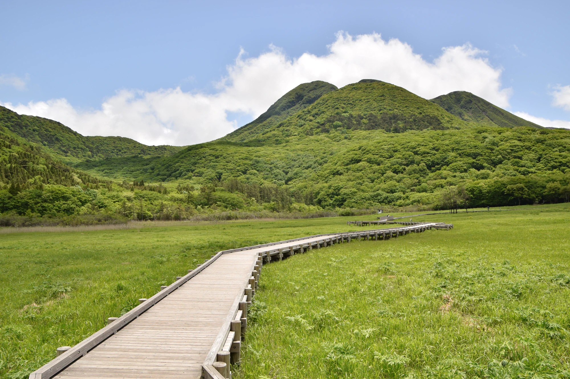
A low wooden boardwalk curves through a bright green wetland toward wooded hills beneath a blue sky.

A wooden boardwalk crosses Tadewara Wetland beneath green hills, photographed on 24 May 2020.

Tadewara Wetlands (52133306063).jpg — Raita Futo, CC BY 2.0 (https://creativecommons.org/licenses/by/2.0/). Source: https://commons.wikimedia.org/wiki/File:Tadewara_Wetlands_%2852133306063%29.jpg. Resized and recompressed as WebP; no crop or retouching. · Creative Commons

Walks and routes

Route A: short scenic boardwalk

A good first choice if your priority is a little fresh air, seasonal plants and mountain views. Follow the signed short circuit from the visitor center and keep the pace relaxed. Allow roughly 30–45 minutes outdoors if you want frequent pauses.

The official route guide identifies Route A as wheelchair-accessible. Ask staff about the approach and today’s surface conditions before setting off. Keep to Route A if you need the accessible option.

Route A: short scenic boardwalk

Route B: wetland circuit

Choose this circuit for more time in the open wetland. It is a useful middle option when the shortest walk feels brief but your group does not want the forest extension. Allow about an hour with stops, and use the center’s map at junctions.

Boardwalk walking; only Route A is explicitly identified as the barrier-free option in the three-route guide. Ask before taking a wheelchair or stroller farther.

Route B: wetland circuit

Route C: wetland and woodland

Add the neighbouring nature-study trail for a change from open sky to broad-leaved trees and moss. The local map allows about 80 minutes; give yourself 1½–2 hours if you plan to stop. At the Amagaike/Bogatsuru junction, keep to your local circuit rather than following the mountain route.

The woodland section is not barrier-free. Expect a natural path rather than a continuous accessible boardwalk, and choose suitable footwear after rain.

Route C: wetland and woodland

Spend 20–30 minutes at the center, check current notices and choose a circuit.

Walk Route A slowly, or choose Route B if everyone wants a longer outing. Pause for one flower, one view and a minute of listening.

Return for the nature display, a rest and a comfortable margin before your bus.

Start with the exhibits and ask about the forest path and any taped-off areas.

Follow the signed Route C circuit, allowing 1½–2 hours for walking and stops. Stay on the local route at mountain-trail junctions.

Finish at the center while it is open, leaving plenty of time for food and your onward journey.

Things to try

Choose one question for the walk

At the visitor center, pick something you want to recognise outdoors: a flower shape, a bird, or the boundary between wetland and woodland. Look for just that one thing first. It gives younger visitors a purpose without turning the walk into a race to tick off species.

Compare grassland and woodland

On Route C, pause once in the open and once beneath the trees. Compare the light, wind and sounds without leaving the path. Then ask why the wetland stays open while trees grow nearby: water conditions and the work of people both belong in the answer.

Make a three-shape nature sketch

Draw a mountain outline, a grass stem and one flower or leaf you can see from the path. Let each take only a minute or two. Keep the boardwalk clear for people passing, and use a photograph to finish the sketch later if the path is busy.

Walk with a local nature guide

Ask the visitor center about upcoming nature walks, the language used and any booking requirement. A guided outing can make a small stretch of wetland surprisingly rich. Check the current programme for dates, meeting times and availability.

Make the center the main visit

Use the films, seasonal displays and viewing room while the center is open. A brief look outside may be enough during light rain, but postpone the walk in thunderstorms, strong winds or heavy rain. Check the return journey as well as the footpath before deciding to wait out bad weather.

Wildlife and habitats

Wild Japanese iris

In summer, watch for purple iris flowers rising above long, narrow leaves. These wild plants are part of the wetland’s summer colour. Look from the boardwalk and compare the flowers with the center’s seasonal photographs.

Sphagnum moss

The mossy woodland is a reason to choose the longer circuit. Sphagnum holds a great deal of water, making a low green carpet an important part of the wetland story. Enjoy its texture from the path; do not press, pull or step onto it.

Great burnet

Later in the flower season, look for compact dark-red heads held on slender stems among the grasses. Their small scale makes a pleasant contrast with the showier blue higotai. A close look with your camera’s zoom is better than stepping into the vegetation.

Eurasian harvest mouse

Tall, damp grassland is also habitat for this easily overlooked small mammal. Think of the grasses as a home rather than an obstacle to a view. Avoid parting stems or searching for nests, and let the visitor center introduce the animal through its wildlife information.

Higotai globe thistle

In August and September, the rounded blue heads can stand above the surrounding grass. Each apparent ball is a cluster of tiny flowers. Try comparing one round flower head with the smaller, darker head of great burnet if both are visible from your path.

Chestnut-eared bunting

Listen for small birds in the grassland before looking for movement. Tadewara’s insects help support birds such as the chestnut-eared bunting. A quiet pause with binoculars is more useful than walking into the grass, and a bird does not have to reveal itself for the listening stop to be worthwhile.

Stories and discoveries

Two wetlands share one designation

The Ramsar site totals 91 hectares: 38 hectares at Tadewara and 53 at Bogatsuru. Their different elevations and approaches matter when planning a day. The easy roadside wetland experience described here is Tadewara.

The view is a conservation project

A landscape that looks wonderfully open can require constant care. As demand for fodder, fuel and thatching grass declined, traditional grassland use also weakened. Continued management and volunteer work help keep these habitats from disappearing beneath trees.

Kuju is a group of volcanoes

The mountain skyline belongs to a group of more than twenty volcanic cones and domes, rather than a single cone. The wetland is a comfortable place to appreciate their shapes, while the visitor center helps explain the geology behind them.

When to visit

Spring: renewal after burning

The landscape may look black just after the managed burn, then green returns. Spring flowers are part of that change. Ask about burning dates and temporary access restrictions; do not approach an active burn to watch or photograph it.

Summer: flowers and changing skies

Choose flower-watching over a fast circuit, and leave room to shorten the walk if showers develop. The highland setting is cooler than the lowlands, but you still need water, sun protection and a layer for wind or rain.

Autumn: seed heads and colour

Look beyond the trees to the changing grasses and late flowers. Mountain walkers also arrive for autumn foliage, so a quieter weekday can make parking and a slow boardwalk visit easier.

Winter: a weather-led visit

A snowy wetland can be beautiful, but snow or ice changes the route choice and the drive. Confirm that the center and the facilities you need are open, check the road and bus notices, and make a shorter indoor-focused visit if outdoor conditions are poor.

Getting there and practical advice

Opening and entry

Chojabaru Visitor Center is free to enter. It normally opens at 09:00, closes at 17:00 in May–October and at 16:00 in November–April, and closes for 29 December–3 January. Check temporary closure notices before a long journey.

Exhibits and a sheltered pause

Look for the large satellite-image display, seasonal nature information and films about the region. The viewing room gives a useful outlook when clouds or rain make a long walk less appealing. Ask staff which film or display will best suit your group and language.

Toilets, equipment and food

Public toilets are shown around Chojabaru, and staff can direct you to the most suitable available one. Ask about wheelchair or stroller loans before setting off. Bring your own drinking water and a snack; check local shop hours if you plan to buy food here.

By train and community bus

Use JR Bungo-Nakamura Station and Kokonoe Town’s through community-bus route toward Chojabaru. The town identifies Kuju Tozanguchi Miyama as the visitor-center stop. The published adult fare is ¥500, checked on 16 October 2026. Services and journey times vary by day, so check the current timetable and your return connection before travelling.

By train and community bus

Seasonal bus differences

The community bus’s section between Kuju Tozanguchi and Makinoto Pass is suspended from 1 December through the end of February. Other operators have different seasons, stops and booking rules; do not combine their departures as though they were one service. Check seat availability before relying on a Kyushu Odan Bus connection.

By car

Set your destination to Chojabaru Visitor Center, beside the Yamanami Highway. The center gives approximately 40 minutes from Kokonoe Interchange in ordinary conditions. Allow more time on busy flower and autumn-colour weekends, use designated parking, and check road conditions before a winter drive.

Choose the short accessible circuit

Route A is the straightforward starting point for wheelchair users and families with strollers. Speak to staff before leaving the building so they can help with the elevator, the best approach and any temporary surface problem. Decide whether your own equipment or a loan chair will work best for the person using it.

Keep the forest optional

The woodland path is fairly level overall, but it is not barrier-free. A similar distance on a natural surface can feel very different from a boardwalk. There is no need to add it to make the visit worthwhile.

Visitor information

Hornets near Chojabaru facilities

The visitor center’s 4 October 2026 notice reports hornets gathering at a tree near the Sensuizan-side toilets in Chojabaru parkland, with exclusion tape in place. Keep clear and ask staff for the current approach. The same notice also concerns a separate mountain-trail location near Bogatsuru; it does not identify the entire Tadewara boardwalk as closed.

Kuju volcanic gas

On 16 October 2026, JMA listed Kuju at volcanic alert Level 1, with a warning about hot gas at the Iozan fumaroles. Climbing Iozan is prohibited. Keep this visit to the marked wetland and local nature paths, obey barriers, and check for new restrictions before travelling.

Aso crater is a separate plan

On 16 October 2026, Aso was at Level 2 and entry within approximately 1 km of the crater was prohibited. Do not plan on crater viewing. If Aso is part of a longer trip, check its own current restriction page; Chojabaru’s local access information does not replace it.

Aso crater is a separate plan

Check the highland forecast

Use Kokonoe’s weather warnings and the western Oita forecast, then ask staff about conditions on the paths. Rain, lightning, fog and winter ice can matter even on a short walk. Turn back early if the weather deteriorates rather than pressing on to complete a circuit.

Check the highland forecast
Sources and useful links

Wildlife you might spot

4

Each card links to a full Explore page with photos, traits, and fun facts.

We are still adding species preview cards for this place.

Snap map for this place

Start with the big picture, then zoom in to explore individual wildlife observations around this place.

Loading map…

Good to know before you go

Check the visitor center’s latest notices before travelling, then ask staff which circuit is best that day.

On 4 October 2026, the center reported hornets gathering near the Sensuizan-side toilets in Chojabaru parkland, with an area taped off. Keep outside the tape and ask whether the restriction is still in place.

Wear shoes with a good grip and bring a warm layer and waterproofs. Wet boardwalks and icy paths deserve a slower pace.

Stay on the boardwalk and marked paths, leave flowers and moss in place, and take your rubbish home.

Check your return bus before setting off. The community-bus stop for the center is Kuju Tozanguchi Miyama; different operators use slightly different stop names.

Bring water and a snack, and use a toilet before starting. Check winter toilet availability rather than relying on every outdoor facility.

Leave room for others to pass when taking photographs. Watch birds quietly and do not part the grasses to search for animals or nests.

Treat any mountain extension as a new hiking plan. Keep away from Iozan’s restricted fumarole area, and check Aso crater restrictions separately if travelling there.

Frequently asked questions

Chojabaru Visitor Center and Tadewara wetland in Kokonoe, Oita. The wider national park crosses Oita and Kumamoto. Aso crater, Bogatsuru and the Kuju summits need separate journeys or hiking plans.
No. Route A is about 800 m and Route B about 1.5 km. Either can be the main outing. The 2.5 km Route C adds woodland and takes longer; choose it only if everyone has the time, footwear and energy.
Plan around the center and Route A. Use the elevator for the change of level and ask staff about the day’s approach and boardwalk surface. Do not assume the longer forest path is suitable. Check the availability and fit of any loan equipment before relying on it.
Admission is free. Published hours are 09:00–17:00 from May to October and 09:00–16:00 from November to April, with closure from 29 December to 3 January. Weather or temporary works can cause additional closures, so check the current notice.
Yes. Kokonoe Town’s community bus links Bungo-Nakamura Station with the Chojabaru area. Use Kuju Tozanguchi Miyama for the visitor center and check both outward and return journeys. December–February suspension applies to the onward section between Kuju Tozanguchi and Makinoto Pass; it is not a blanket closure of the whole route.
No. Kuju’s Iozan fumaroles release hot volcanic gas, and climbing Iozan is prohibited. Follow local barriers and staff advice. Aso has its own alert and crater restrictions; a wetland visit does not establish whether crater viewing is possible.
Leave them where they grow. Observe and photograph from the path, and keep children close on the boardwalk. The fragile vegetation and the small animals living among it are part of what makes this wetland special.

Recent snaps at this place

Recent snaps will appear here as new observations are added.

View all ›

Take the discovery with you

Exploring Aso-Kuju National Park?

Identify the wildlife you spot, learn as you go, and keep a collection of the adventure.

  1. 1Spot it
  2. 2Snap it
  3. 3Keep the discovery