
Snappit logo
Snappit
Get App
Generic illustration, not a photograph of this venueIllustration
ParkProvence-Alpes-Côte d’Azur, FR

Calanques National Park

The revealing thing about the Calanques is how abruptly mountains meet the Mediterranean.

About

The revealing thing about the Calanques is how abruptly mountains meet the Mediterranean. A viewpoint can show you more of that geography than a crowded beach. At Sugiton, the Torpilleur islet helps you locate the inlet below; Morgiou lies in the next fold of coast, with the Riou islands farther out. Leave time to look across the slopes as well as down at the water.

This guide covers the whole Parc national des Calanques in Bouches-du-Rhône, Provence-Alpes-Côte d’Azur, while concentrating the practical visit on Luminy, in southern Marseille. The land core extends across Marseille, Cassis and La Ciotat; the adjoining membership area also includes La Penne-sur-Huveaune. Those different sectors need their own route planning. A walk to Sugiton does not introduce every part of this park.

White limestone is the familiar image, but the wider landscape is more varied. The Luminy–Sugiton strip includes dolomitic limestone, while the Canaille massif farther east contains sandstone and conglomerate as well as limestone. Looking toward the contrasting cliffs is a useful reminder that the protected coast is more than a sequence of interchangeable coves. Explore the grounds like a pro—download the Snappit app to instantly identify animals and plants.

The national park was created on 18 April 2012, but Luminy’s history is much older. A rural estate with fields, grazing and woodland preceded the university campus established in the 1960s. Around Sugiton, the surviving sheepfold remains make that working landscape easier to imagine: these slopes were used and shaped long before they became a celebrated day-trip destination.

What to do here

Choose the Luminy–Sugiton belvedere return walk, look for changes between woodland and open rock, and pause for the coastal panorama. Keep the beach descent as a separate, more demanding decision. The viewpoint outing is satisfying without adding a swim or a second cove.

Seasonal info

Summer brings the most difficult combination of heat, busy approaches, fire restrictions and, on specified dates, reservations for the Sugiton/Pierres Tombées coastal zone. Cooler months still require a weather check. If conditions deteriorate, shorten or postpone the walk rather than trying a steeper alternative.

Accessibility

This is a walking outing on an ascending, uneven track with an exposed lookout destination. It is not a verified wheelchair-accessible route. Children need close supervision near drops; adults should be comfortable turning around before the viewpoint if footing, wind or fatigue becomes a problem.

Don't miss

1

The view into Sugiton and neighbouring Morgiou from one high coastal position

2

The transition from Luminy’s pine woodland to open limestone slopes

3

Traces of pastoral life around the col de Sugiton

4

A national park that continues offshore into island and marine habitats

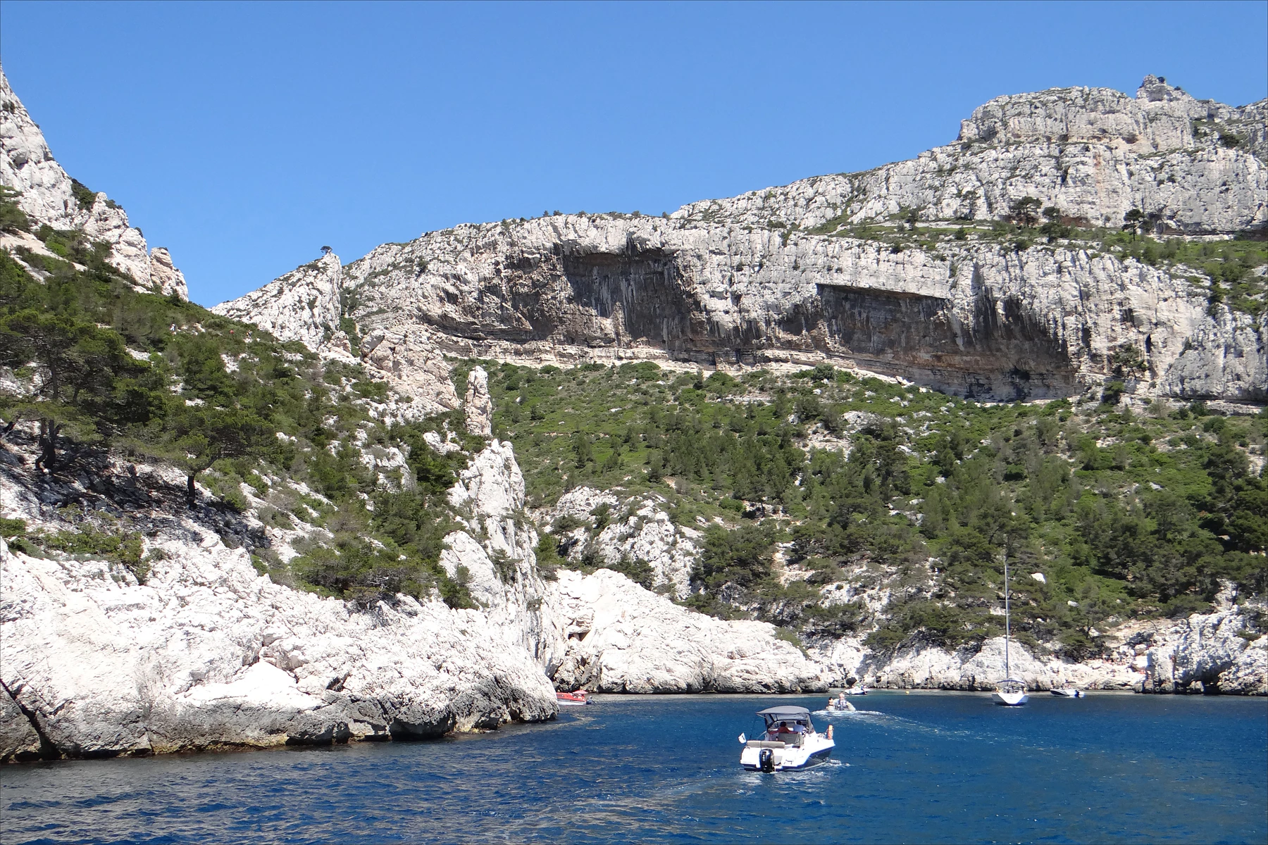
Pale limestone cliffs and green scrub above deep-blue water at Morgiou, with several small boats in the foreground.

Morgiou, a different cove from the featured Sugiton walk, photographed on 9 May 2014. This historical coastal view does not show today’s access, sea conditions or boating permissions.

“La calanque de Morgiou (Marseille)” — Jean-Pierre Dalbéra, CC BY 2.0. Source: https://www.flickr.com/photos/72746018@N00/14228814134. License: https://creativecommons.org/licenses/by/2.0/. Original photograph, unchanged. · Creative Commons

Walks and routes

Luminy to the Sugiton belvedere and back

The Marseille tourism office publishes 5.0 km return and 105 m of cumulative ascent for this itinerary. Start at the barrier into the domaine de Luminy, follow the main ascending track through the woods to the col de Sugiton, then take the signed belvedere branch to the right. The track ends at the foot of the lookout. Return by the same route; do not follow the separate downhill route into the calanque. Use the linked official route for orientation rather than this summary alone.

The tourism office describes the approach as suitable for an all-terrain pushchair. That does not establish step-free access to the final viewpoint, wheelchair suitability or easy passage in all conditions. Expect uneven ground and gradients; seek current, specific advice if your visit depends on pushchair or mobility access.


Luminy to the Sugiton belvedere and back

A half-day from Marseille

Before leaving the city, check access and weather, fill bottles and decide on the return journey. Take the bus to Luminy, walk to the col and continue to the belvedere only if conditions suit the whole group. Give the panorama time, then retrace your approach. Keep a meal or another city visit for afterwards rather than carrying an ambitious beach plan into the afternoon.

Things to try

Read the coast from above

At the lookout, first find the narrow inlet of Sugiton and the Torpilleur rock, then turn toward Morgiou. Comparing the two coves helps make sense of the repeated headlands and recesses. Bring binoculars if you enjoy distant details, but use them while standing still in a secure position, away from the edge.

A woodland walk with a clear turning point

The col makes a useful decision point before committing to the exposed destination. Ask whether everyone is comfortable, has enough water and can complete the return. If the answer is no, retracing the woodland approach still gives you a worthwhile introduction to Luminy. Do not turn a shorter walk into an improvised cross-country loop.

When the coast is the wrong choice

In strong wind, heavy rain, poor visibility or a closure, postpone the viewpoint and spend the time in Marseille. A different cove is not automatically a sheltered substitute, and a boat trip has its own weather limits. Keep the Calanques for a day when the journey out and the walk back both look sensible.

Wildlife and habitats

Aleppo pine

The characteristic pine of the Calanques can grow on dry, poor limestone ground. Look at its irregular, wind-shaped outline and grey-brown bark from the path. It is a good woodland subject because you can study a tree without needing wildlife to appear on cue.

Peregrine falcon

Peregrines nest on the park’s coastal cliffs and hunt birds. The nesting protections around the Toits cliffs above Sugiton explain why an apparently empty wall can need quiet. A distant bird may pass overhead, but identification is uncertain at range; enjoy the possibility without seeking out a nest.

Yellow-legged gull

Marseille’s familiar gabian has a white body, grey back and black wingtips; adults have yellow legs. The park documents breeding colonies on the Marseille islands. Watch passing birds with binoculars, leave food packed away and give any birds defending young plenty of room.

Neptune grass

Below the surface, Neptune grass forms underwater meadows. It is a flowering plant, not seaweed, and anchors can damage it. You will not identify these meadows reliably from this walk: their importance is a reason to think of the sea as habitat rather than empty blue scenery.

Stories and discoveries

A sheepfold among the rocks

A jas is a sheepfold built away from the settlement. The jas de Sugiton survives as stone remains below mont Puget, evidence of the sheep and goats that once used these slopes. Notice it from the established route; ruins are part of the landscape to understand, rather than a climbing frame.

Why there is concrete beside the track

Some retaining walls by the belvedere approach date from German military works during the Second World War. The same clear views that draw visitors today made the coast strategically important. The lookout’s setting connects the natural panorama with a very different chapter of local history.

A forest growing on thin ground

The patches of soil between the rocks matter disproportionately here. Vegetation helps hold that soil, while repeated shortcuts enlarge bare ground. Staying on the marked line is a practical way to let young plants re-establish themselves, especially around the heavily visited Sugiton sector.

When to visit

Fire access: check the right massif and date

From 1 June to 30 September, the prefecture assesses access daily. The next day’s decision is normally available by 18:00. Consult the official access information or Mes Calanques for the Calanques massif, and check again before departure. A red closure rules out this land-based walk. Booking Sugiton does not override a fire closure; affected reservations are cancelled.

Sugiton reservations: a coastal zone, specific dates

The published 2026 reservation dates were 20–21 June, every day from 27 June to 30 August, 5–6 September and 12–13 September. These dates have passed. They applied to the Sugiton and Pierres Tombées coastal zone, not the belvedere-only itinerary. Reservations were free, opening three days before a visit at 09:00 and closing at 18:00 the day before. For a future summer, consult the new season’s page: do not reuse the 2026 calendar.

Cooler seasons and nesting cliffs

A clear autumn or winter day can make the panorama more comfortable, but gusts and wet rock can still change the plan. In spring, wildlife needs space around the cliffs; respect temporary restrictions protecting nesting birds. Watching from an established path is preferable to searching for nest sites.

Getting there and practical advice

Prepare before the trail

There are no dependable shops, toilets or bins on the walk or at the remote beaches. Use facilities before starting, carry food, and take all rubbish back to town. Do not plan around finding a staffed visitor centre at the viewpoint. The absence of services is part of the reason to keep the first visit manageable.

B1 to Luminy

RTM’s B1 links Castellane with Luminy; the gateway stop is Luminy – PN des Calanques. Check the operator’s journey planner for your exact departure and return, including evening service and disruption notices. Check return options before committing to a late walk, and allow time to reach the stop before your bus.

If you arrive by car or bicycle

Parking near Luminy can fill quickly, so the bus is the simpler first choice. A road or parking space is not permission to enter a closed massif. Cycling can get you to the gateway, but the domaine de Luminy has its own ban on cycling within the woodland; leave the bicycle before the walking route.

Choose the outing for the least confident walker

A modest ascent figure says little about heat tolerance, footing or comfort near heights. Keep children close at the lookout and stop for snacks well back from drops. If someone needs a reliably level, step-free outing, arrange a different visit with confirmed access rather than assuming that the broad approach track continues unchanged to the panorama.

Sources and useful links

Wildlife you might spot

4

Each card links to a full Explore page with photos, traits, and fun facts.

Snap map for this place

Start with the big picture, then zoom in to explore individual wildlife observations around this place.

Loading map…

Good to know before you go

Choose footwear with reliable grip; smooth soles are a poor match for the rock.

Carry at least 1.5 litres of water per person for a half-day, and more in hot weather or for a longer outing, following the park’s advice.

Bring sun protection, a windproof layer, food and a bag for all your rubbish.

Save the official route information before leaving and follow marked, open paths.

Do not step across fenced or roped regeneration areas, even for a photograph.

Keep dogs on a lead and carry their water too; the Luminy woodland is not a cycling shortcut.

Frequently asked questions

General access is free. Seasonal Sugiton reservations cover a defined coastal zone, not every visit to the park. Transport and any independently booked activities have their own charges.
No. The descent changes the effort and the return substantially. The park warns that the climb back from the calanque is steep and can take at least an hour; do not add it because the water looks close from above.
Sugiton is not a lifeguarded beach. A permitted visit or a reservation is no guarantee of safe sea conditions. This guide’s recommended walk stays above the coast and does not include a swim.
The tourism office describes a fountain near the departure barrier, but its operation is not guaranteed. Arrive with your full water supply; there are no refill points along the featured route.

Recent snaps at this place

Recent snaps will appear here as new observations are added.

View all ›

Take the discovery with you

Exploring Calanques National Park?

Identify the wildlife you spot, learn as you go, and keep a collection of the adventure.

  1. 1Spot it
  2. 2Snap it
  3. 3Keep the discovery




