Snappit logo
Snappit
Get App
Generic illustration, not a photograph of this venueIllustration
ParkTohoku, Japan

Chokai Quasi-National Park

Chokai Quasi-National Park stretches across Akita and Yamagata, linking a 2,236-metre volcano with very different landscapes at sea level.

About

Chokai Quasi-National Park stretches across Akita and Yamagata, linking a 2,236-metre volcano with very different landscapes at sea level. High on the mountain, paths lead through low vegetation towards the blue bowl of Lake Chokai. Below, forests and wetlands hold water from snow and rain. At Kisakata, wooded hummocks stand among fields where a lagoon once lay. Far offshore, Tobishima adds fishing villages, rocky shores and the chance to watch migrating birds.

The easiest way to enjoy it is to choose one landscape for the day. Hokodate offers a mountain-and-sea view without committing to a summit climb. Fit walkers can plan a summer return hike to Ohama, the viewpoint above Lake Chokai. On a coast-focused day, the small Buddhist figures at Juroku Rakan Iwa invite a slower kind of looking. Tobishima deserves its own ferry-based plan, with the return sailing decided before you start walking.

This is a large protected landscape with many entrances, working communities and separately operated facilities. It has no single front gate or universal opening time. The wider Chokai and Tobishima Geopark helps explain the region, but its area is not identical to the quasi-national park. Treat towns, stations and roadside stops as gateways, rather than assuming everything around the mountain lies inside the designation.

You do not have to climb high to understand the place. Watch clouds gathering on the mountain from the coast, compare lava shapes with a smooth pebble shore, or spend ten quiet minutes following a bird through binoculars. Leave enough room in the day for those small discoveries. Don't forget to bring the Snappit nature identification app along to scan local species.

The park brings together landscapes shaped by eruptions, slope collapse, earthquakes, snow and the sea. People have added shrines, fishing settlements and routes across this terrain. The protected scenery is also a lived-in place, so quiet observation and respect for local work are part of a good visit.

What to do here

Pick one of the three outings below. Add a visitor-centre stop or a short Kisakata landscape visit if it fits your transport. Keep the summit, the southern mountain approaches and Tobishima’s western shore as separately planned adventures.

Seasonal info

Mountain spring can still mean winter equipment and route-finding across snow. Autumn brings shorter days and early freezing conditions. A road reopening does not establish that a trail is snow-free, and a pleasant afternoon on the coast says little about summit weather.

Accessibility

For a lower-effort visit, begin with an individually checked viewpoint or visitor centre. Mountain trails, narrow wetland boardwalks and rocky shores are not verified step-free routes. Ask about the exact entrance, toilet, surface and gradients before choosing a stop; ferry boarding also needs separate confirmation.

Don't miss

1

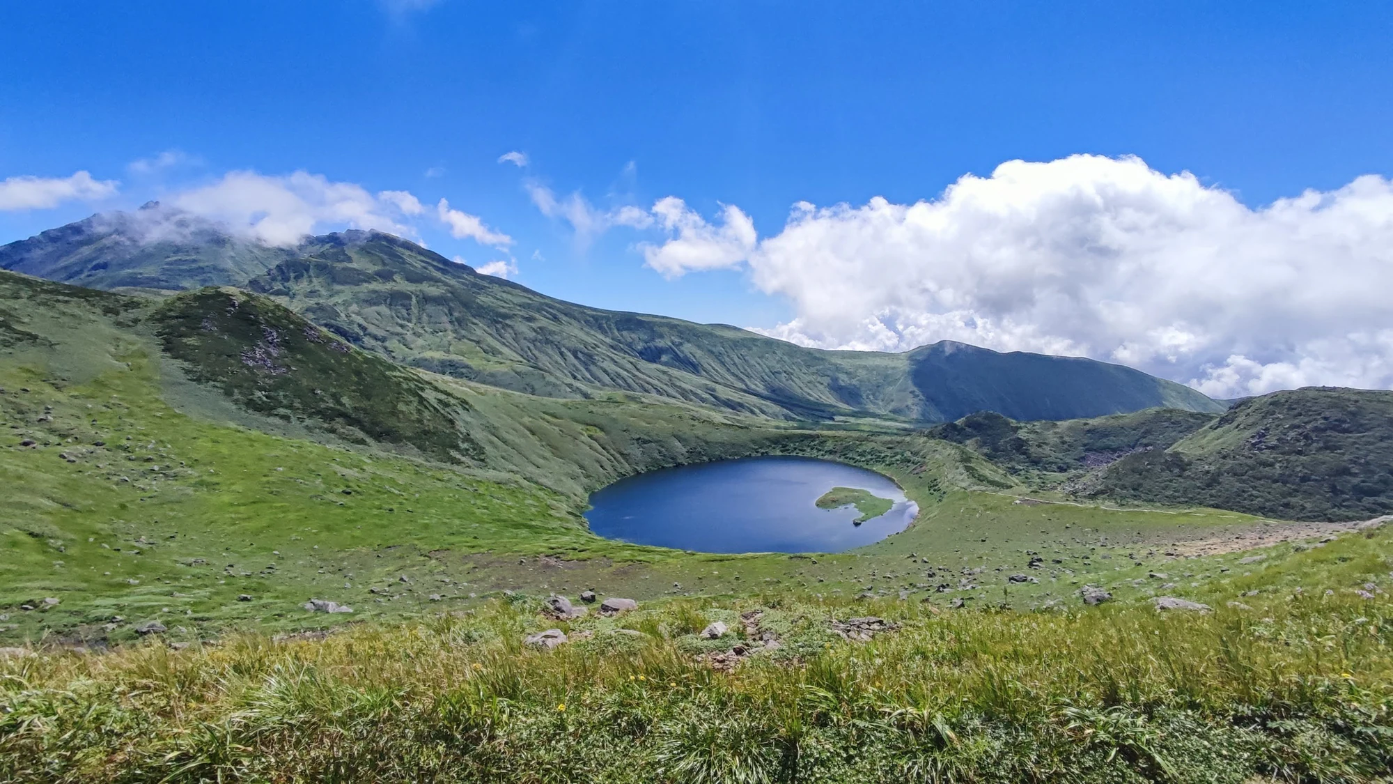
Lake Chokai seen from Ohama, well below the summit

2

Hokodate’s view into Naso Gorge and out towards the sea

3

Kisakata’s former islands standing among cultivated fields

4

Juroku Rakan Iwa’s carved figures and volcanic shoreline

A deep blue lake sits in a hollow among green mountain slopes, with a rocky ridge, white clouds and blue sky beyond.

A mountain lake beneath Chokai’s green slopes, in a Japan Meteorological Agency photograph. The capture date is unknown; this image does not show current snow, weather or trail conditions.

Source: Japan Meteorological Agency, 日本の活火山の写真集: 鳥海山写真02, https://www.data.jma.go.jp/vois/data/filing/kazanbosai/volpictures.html#209. PDL1.0: https://www.digital.go.jp/resources/open_data/public_data_license_v1.0. No changes. · Creative Commons 1 · www.digital.go.jp 2

Walks and routes

A summer mountain walk to Ohama

From Hokodate trailhead, follow the mapped mountain path to Sainokawara, then continue to Ohama and the Lake Chokai viewpoint. Make this the turnaround and return the same way. The official map separates the lake-side branches and the onward route through Shimekake towards the summit; neither is included here. Ohama is about 1,700 m above sea level, not 1,700 m of ascent.

The current official table gives 2 hours up and 1½ hours down, excluding breaks. Allow 4½–5½ hours editorially, and more if conditions or your pace require it.

Uneven mountain path with climbing, steps, weather exposure and possible snow. Unsuitable for wheelchairs or pushchairs; shorter than the summit does not mean easy.


Sea air and the coastal carvings

Start at the parking area by Sunset Jurokurakan, shown in the official Fukura map inset. Use the pedestrian bridge and designated path to the carved-rock viewing area, then return the same way. Dewa Futami’s paired rocks lie to the south; enjoy them only from permitted viewing places. This short visit does not require a scramble across the shoreline or a beach crossing.

Allow 30–60 minutes at the site, editorially. The tourism association lists a further 15-minute walk each way between Fukura Station and the attraction.

The source confirms a bridge and walking path, but does not establish a continuous step-free route. Check steps, slopes and weather exposure before travelling.

A manageable first look at Tobishima

From the ferry landing at Katsuura, use the 2026 island map to follow the inhabited eastern shore towards Nakamura. Choose a turnaround that leaves ample time to return to the landing. This deliberately flexible out-and-back avoids assuming you can complete the island’s western-shore paths, which the map marks with caution sections. Stay clear of working fishing areas and let residents and vehicles pass.

Allow 60–90 minutes for a short village-and-shore stroll, editorially, within a full ferry travel day. Set your actual limit from the confirmed return boarding time.

Roadside walking still involves traffic, slopes and uneven edges. The guide does not certify a wheelchair route or accessible ferry transfer; ask the operator about both.

Things to try

Read Kisakata’s landscape

At Kanmanji’s gate, look for the signed former approach and the viewpoint towards Komadome-jima just to the north. Imagine water filling the fields between the wooded hummocks. This is a short observation stop, not an invitation to cross farmland. Nemu no Oka’s viewing room offers a wider perspective when open. Allow 30–60 minutes editorially, plus travel.

Try a mountain day without the long climb

Visit Hokodate’s viewpoint and, when open, its visitor centre. On the northern approach, Ryugahara Wetland at Haraikawa offers a different setting of ponds and boardwalks. Choose one gateway and remain on the permitted boardwalk; continuing into the climbing trail is a separate decision. Check road, snow and toilet status first.

Make a family field notebook

Choose three shapes to sketch: a cloud over the mountain, a lava rock seen from the path and a bird’s silhouette. On Tobishima, watch a small patch of shore quietly rather than chasing a rare bird. Children can compare observations afterwards; no collecting or perfect identification is needed.

Stories and discoveries

The islands that stayed behind

Kisakata’s hummocks originated in a collapse of Chokai. An earthquake in 1804 raised the lagoon floor, helping create the striking field-and-island landscape seen today. A mountain and a coastal view can therefore tell two parts of the same story.

Sixteen in the name, twenty-two in the rock

Juroku Rakan Iwa contains 22 Buddhist figures, including the sixteen arhats. Completed in 1868, they express prayers for those lost at sea and for maritime safety. Treat the carvings as a place of memory as well as an intricate work to look for.

Snow shapes the vegetation

Chokai’s heavy-snow environment supports beech woods, low shrubs and snowbed plants without the continuous subalpine conifer belt familiar on some other mountains. The locally distinctive Chokai-fusuma and Chokai-azami are part of that botanical story. Admire wild plants where they grow.

An island with a different volcanic past

Tobishima’s rock tells a much older story of underwater volcanism, uplift and erosion. It is not simply a piece of Chokai’s summit floating offshore. Its migration-season birds and coastal plants give the park another character entirely.

When to visit

Spring

On Tobishima, late April to mid-May is a customary migration window. Mountain slopes can still carry extensive snow after roads reopen. Keep a coastal alternative if you lack snow-travel experience.

Summer

July and August are the principal mountain-walking months. Look for alpine flowers without leaving the path; snow may persist in hollows. Tobishima’s early-summer daylilies and later orange tiger lilies add colour, with timing dependent on the year.

Autumn

Tobishima’s autumn migration period commonly runs from late September into November. Mountain colour descends as cold arrives; huts close early and daylight shrinks. Use dated notices, rather than a previous autumn photograph, to plan.

Winter

Treat the mountain as a winter mountaineering environment, with seasonal road closures and limited facilities. Coastal and island trips also need flexibility for snow, wind and rough seas. A clear forecast and confirmed transport matter more than a long sightseeing list.

Getting there and practical advice

For western mountain access, use Kisakata or the Yuza/Fukura side and the seasonal Chokai Blue Line. Hokodate is listed about 30–40 minutes by car from Nemu no Oka, before delays. Haraikawa is a different northern approach, about 50 minutes by car from Yashima Station. Do not use one trailhead’s journey time for another.

Hokodate has parking, a visitor centre and separately operated lodges; seasonal availability varies. Ryugahara’s city listing gives an entrance toilet but no shop, so arrive supplied. Juroku Rakan Iwa has toilets by the parking area. These listings do not guarantee that every toilet is open on your day.

As checked on 19 October 2026, the published ordinary Tobishima ferry fare is ¥4,280 adult return or ¥2,140 one way; the child fare is ¥2,140 return or ¥1,070 one way. Ask about age rules and any applicable discount. Coastal carving viewing and Hokodate parking are listed as free; budget separately for meals, guides and accommodation.

No complete accessible outing has been verified here. Ask the relevant office for the distance from parking or landing to your chosen view, steps, resting places and an open accessible toilet. A boardwalk symbol does not establish its width, passing space or suitability for a mobility aid. If ferry assistance is needed, discuss the boat, gangway and island-side transfer before booking.

Active volcano and mountain weather

JMA’s Chokai page showed Alert Level 1 when checked on 19 October 2026. It still warns that gas, fumes or ash can emerge suddenly in the potential vent area. Recheck the latest bulletin, mountain forecast and local closures before entering. Level 1 does not mean a mountain route is safe.

Keep the outing within your plan

For the Ohama walk, turn back at the viewpoint rather than following others towards the summit. Avoid snow-covered or flooded sections beyond your skills. On the island, turn back early enough for boarding. Keep a mainland alternative for rough-sea days.

Protect living landscapes

Leave alpine vegetation and wetland margins untouched. In villages, stay out of fields and school grounds unless invited. Watch gulls without approaching breeding sites; a historic colony label on a map is neither access permission nor a promise of nesting birds.

Visitor information

Checked 19 October 2026: mountain season has ended

The 15 October climbing update closes the ordinary summer season. Ohama and summit huts have finished business and their toilets are closed; Takinokoya has also ended business. At Shimekake, the old path is unsafe because of rockfall: use the designated new path when the route is otherwise open.

Road and approach restrictions

Blue Line night closures are scheduled from 23 October 2026, 17:00–08:00; winter closure begins 4 November at 17:00. Weather can change these times. Separately, the Momoyake approach remains inaccessible after damage to Teshiro Forest Road; no reopening date is given.

Ferry service and seasonal taxis

Sakata announced the return of the vessel Tobishima from 30 September 2026 after repairs. That is not confirmation of any particular sailing. The Yuza/Sakata shared mountain-taxi service has finished its 2026 season; arrange and confirm any alternative transport in advance.

Wildlife you might spot

2

Each card links to a full Explore page with photos, traits, and fun facts.

Snap map for this place

Start with the big picture, then zoom in to explore individual wildlife observations around this place.

Loading map…

Good to know before you go

Carry a detailed walking map offline, waterproof layers, water, food and a headlamp for mountain outings. Submit a climbing plan and choose a turnaround time before setting off.

Stay on paths and boardwalks, including when photographing flowers. Do not pick plants, move rocks, feed wildlife or enter private fields to get closer.

Check bear reports and local restrictions before woodland or mountain walks. Keep food secure, avoid surprising animals and turn back if a route is closed.

Treat the coast as exposed even on a sunny day. Keep children beside you near harbours, rocks and cliff edges; rough water is a reason to stay well back.

Bring binoculars rather than expecting close wildlife encounters. Birds need space to rest and feed, especially during migration.

Take rubbish home and carry a portable toilet kit for the mountain. Seasonal toilets and huts may already be closed when access roads remain open.

Frequently asked questions

The lake outing involves a mountain hike to Ohama. Hokodate has its own rewarding gorge and sea views, but do not confuse that roadside stop with arriving at the lake.
No. The tourism association advises about 11–12 hours for a summit return outing including rests, depending on route and ability. Steep rock, exposure and falling stones make it a different undertaking from the Ohama walk.
Juroku Rakan Iwa viewing is free, and the Hokodate tourism page lists free parking. Ferries, accommodation, guiding and individual attractions have their own charges. There is no single admission ticket covering this whole landscape.
Plan them on separate days. The boat timetable gives a limited island visit, while a mountain outing needs its own weather window, transport and safety margin.
Do not count on it. Sakata City’s August 2026 update says nesting has not been confirmed there since 2014, although nesting continues elsewhere in the island group. Enjoy any birds from a respectful distance.
Yuza Chokai Tourism Association: 0234-72-5666. Nikaho Tourism Association: 0184-43-6608. Yurihonjo tourism office: 0184-24-6376. Sakata’s ferry office: 0234-22-3911. Check opening hours and ask about your specific date and route.

Recent snaps at this place

Recent snaps will appear here as new observations are added.

View all ›

Take the discovery with you

Exploring Chokai Quasi-National Park?

Identify the wildlife you spot, learn as you go, and keep a collection of the adventure.

  1. 1Spot it
  2. 2Snap it
  3. 3Keep the discovery