
Snappit logo
Snappit
Get App
Generic illustration, not a photograph of this venueIllustration
ParkOccitanie, FR

Grands Causses Regional Nature Park

The Grands Causses are best understood as a working landscape.

About

The Grands Causses are best understood as a working landscape. Open plateaux, villages, wooded valleys and sheep pastures belong to the same story: people have adapted to thin soils, porous rock and a water supply that is often hidden underground. At the Source du Durzon, that invisible system becomes something you can hear and watch from the bank.

For a first visit, choose the valley walk below rather than trying to fit every gorge and plateau into one day. Nant makes a useful nearby base; Millau is a larger gateway for information, transport connections and the local museum. The park extends across southern Aveyron and northern Hérault in Occitanie. Its 2024–2039 boundary includes the Lodévois-Larzac, so older Aveyron-only descriptions miss part of the present park.

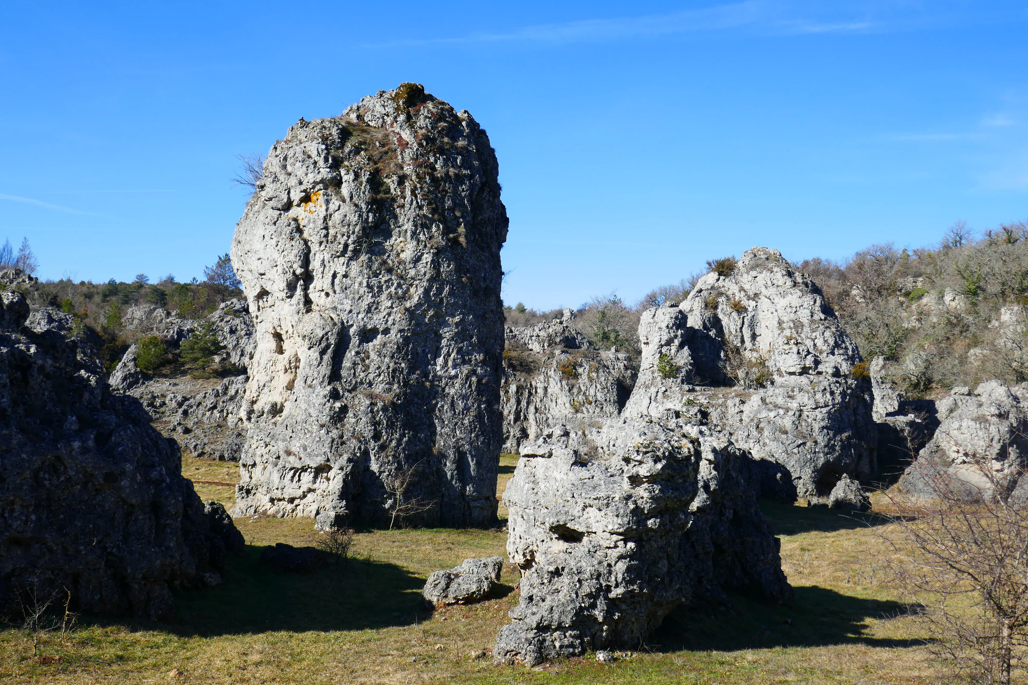
The landscape atlas distinguishes the limestone causses, the lower avant-causses, the red sandstone country of the rougiers and the surrounding uplands. The contrast is worth noticing as you travel: the pale, rocky horizons in the photograph are one part of this region, while the Durzon outing explores its greener, water-fed side. Planning to visit? Download the Snappit app to identify the wildlife you spot in real-time.

The park was created in 1995, following local efforts to protect the landscape and sustain its rural communities. Its origins are linked to the campaign against extending the Larzac military camp, which ended successfully in 1981. The 2024 extension into the Hérault brought the whole Larzac plateau into the park. This is a lived-in territory with farms, towns and businesses; the park designation does not turn every field, cave or rock formation into public recreational land.

What to do here

Walk to the Durzon spring, watch the change from meadow to woodland, and return to Nant to explore its relationship with water. Keep a separate day for another sector of the park; the distances between its landscapes deserve more than a rushed drive.

Seasonal info

The streamside route and the exposed plateaux behave differently. After sustained rain, postpone the spring walk if water is high or the path is muddy. In cold weather, shaded ground can stay slippery after the air warms up.

Accessibility

The Durzon loop is graded very easy for walkers, but its narrowing earth path, footbridge and road section do not make it a verified wheelchair or pushchair route. Millau has more clearly documented accessible indoor options, detailed below.

Don't miss

1

A karst spring that reveals where the Larzac’s water goes

2

Meadows and woodland on the official Source du Durzon loop

3

Nant’s canals and the long history of managing water

4

A wider landscape shaped by sheep farming, geology and vulture conservation

Tall, weathered grey rock towers stand among short grass, shrubs and leafless trees beneath a blue sky.

Dolomitic rock towers at Les Rives, photographed on 17 February 2023. This is the Hérault side of today’s park, separate from the Durzon walk near Nant; the photograph predates the 2024 boundary extension.

“Chaos dolomitique des Rives” — Lionel DUCHOISELLE, CC BY-SA 3.0. https://www.geodiversite.net/media2249. https://creativecommons.org/licenses/by-sa/3.0/. Original unchanged. · Creative Commons

Walks and routes

La Source du Durzon: the first-visit walk

Start at Pont du Mas du Pré on the D178, about 4 km from Nant village. The official loop is 5 km with 75 m of ascent and takes 1 hour 45 minutes. It follows meadow edges into woodland, reaches the spring and returns over a concrete footbridge towards Mas de Pommiers, then by road. Keep to the public route at the small Pont Hugo: the bridge leads to private property.

Use the official route sheet for junction-by-junction directions. It also allows a return along the outward path, which avoids the road return; the published loop distance does not describe that variant. You can turn back earlier if the ground or your group’s energy calls for it.

Suitable as a modest walk for children already comfortable covering this distance, with adult supervision at the water. The official grade describes walking difficulty, not step-free access. Do not assume a buggy, wheelchair or assisted hiking chair will pass.


La Source du Durzon: the first-visit walk

A relaxed half-day

Check conditions in Nant before heading to the trailhead. Give the walk the first part of the day, with a proper pause on dry ground away from the water’s edge. Return to the village for lunch or a snack, then choose a short look at the canals or the abbey church if it is open. If the walk feels like enough, stop there: the purpose is to enjoy one landscape well, not complete a list.

Things to try

Follow the water into Nant

After the walk, make the village your second chapter. Nant’s canals helped turn a wet valley into productive ground, and its abbey church and old streets put that ingenuity in a human setting. Choose a small part of the village rather than adding another full walking circuit. Ask the tourist office which lanes are open, since village works can affect the usual heritage route.

Look closely at the grassland

On another visit to the Larzac, spend time looking at the low vegetation rather than heading straight for a skyline. The local tourist office describes a remarkable variety of wild orchids in this sector. A botanical outing with a local guide can reveal more than a hurried attempt to name every flower. Stay on paths, do not pick specimens and avoid trampling plants to improve a photograph.

Meet the ancient causses indoors

The Musée de Millau et des Grands Causses, or MUMIG, at Hôtel de Pégayrolles on Place Foch, has fossils that help explain the region’s geological past. Allow roughly an hour for a focused family visit, longer if other collections catch your interest. Its own 2026 schedule lists free admission, Tuesday–Saturday in October–December, 10:00–12:30 and 14:00–18:00. Check the current schedule before setting off, especially on Sundays, Mondays and holidays.

Wildlife and habitats

Fire salamander

The official Durzon walk highlights the black-and-yellow fire salamander. Think of it as an inhabitant of damp woodland around the stream, rather than something to search for in the water. Watch the path as you walk, leave logs and stones undisturbed, and never handle an animal for a closer photograph.

Griffon vulture

Above the wider causses, a large bird circling on broad wings may be a griffon vulture. The park describes its pale neck ruff and brown-to-buff plumage, and the return of cliff-nesting colonies after reintroduction. Binoculars help, but a distant silhouette is not always enough for an identification.

Cinereous vulture

The cinereous vulture is another conservation story of the Grands Causses. Unlike the cliff-nesting griffon, it builds its nest in a tree. Look from established paths and ordinary public viewpoints; seeking out nests would disturb the very birds people have worked to bring back. Neither vulture is promised on the wooded Durzon loop.

Stories and discoveries

The spring connects two landscapes

The apparently dry plateau and the green valley are linked underground. Rain enters cracks in the Larzac’s limestone, travels through the karst and emerges at springs such as the Durzon. That makes the water you see part of a much larger system than this little valley. Protecting the ground above matters to the quality of the water below.

Sheep have helped make the view

Open grazing land is not simply land where woodland failed to grow. Generations of farming and grazing have helped maintain these habitats. The park lies within the wider Roquefort production area, where Lacaune sheep are prominent. The same sheep-farming economy also connects with Millau’s history of leatherworking and glove-making.

A landscape with a World Heritage story

UNESCO inscribed the Causses and Cévennes cultural landscape in 2011 for its Mediterranean agro-pastoral heritage. The value lies in the relationship between land, farming and communities, not simply in dramatic scenery. The inscription covers a defined area of its own; it does not mean that every part of this regional park belongs to the World Heritage property.

When to visit

Spring

Fresh vegetation makes the contrast between the plateau and the valley especially interesting. Choose a settled spell, and do not confuse greener scenery with firm ground underfoot. A local botanical walk can complement the water theme.

Summer

Shade beside the Durzon is welcome, but it does not remove heat or fire risk. Start early, carry enough water and choose a shorter outing if necessary. Check access restrictions for the actual department and sector you plan to visit.

Autumn and winter

Expect wet leaves, short days and possible frost. Check for hunting activity locally and respect signs for an organised hunt; there is no universally hunting-free weekday to recommend. Strong wind, heavy rain or high water are good reasons to choose an indoor visit.

Getting there and practical advice

Supplies and advice

The Office de Tourisme Larzac et Vallées is at Place du Claux in Nant: +33 (0)5 65 62 23 64. Use it for current route and road advice before going out; check its seasonal opening days first. Do your food, water and toilet planning in the village. A toilet, drinking-water tap or staffed shelter at the Durzon trailhead is not confirmed.

Parking thoughtfully

The route sheet places the start parking on the D178 just before Pont du Mas du Pré when approaching from Nant. Use the designated space and obey current signs. If it is full or restricted, ask for another lawful option; do not block the bridge, farm entrances or narrow verges. The nearer Mas de Pommiers approach is not a promise of available or accessible parking.

Arriving through Millau or Nant

Millau is a useful transport gateway. The bus-station website lists liO line 217 between Millau, La Cavalerie, Nant and Saint-Jean-du-Bruel, with a timetable effective from September 2026. Check the exact date, school-holiday pattern and return service before relying on it. A bus to Nant does not complete the journey to a trailhead about 4 km outside the village. Arrange that final transfer in advance; do not casually add a roadside walk to the family route.

Moving around the wider park

Plan each outing around one sector. A car can simplify rural trailhead access, but the road through a valley is part of the journey, with limited stopping places. Stop only in a proper parking area when looking at birds or taking photographs. Never follow a navigation app through a closure or along a farm track simply because it appears shorter.

Choose access by the actual place

For an indoor nature-and-history visit, the MUMIG in Millau has more specific access information: its palaeontology collection, temporary exhibition room, workshop space and shop are listed as wheelchair-accessible. The basement and first-floor collections are not served by a lift. Contact the museum about your particular needs before travelling.

Outdoor alternatives and assistance

The Site du Viaduc de Millau at Brocuéjouls lists reduced-mobility access, but check the exact building-to-viewpoint route you want, along with toilets and parking. That listing does not certify every outdoor path. For assisted countryside outings, Millau’s tourism office describes the two-wheeled Bécasine chair for broad, rolling paths with helpers. Since 1 October 2026, requests go to Comité Handisport Aveyron rather than the office’s summer loan service. Get advice on equipment, helpers and a suitable route; the Durzon loop is not certified for this chair.

Sources and useful links

Wildlife you might spot

3

Each card links to a full Explore page with photos, traits, and fun facts.

Snap map for this place

Start with the big picture, then zoom in to explore individual wildlife observations around this place.

Loading map…

Good to know before you go

Download the official route sheet before setting out and keep enough phone battery for the return.

Wear shoes with grip; a short walk beside water can still have slippery ground.

Bring drinking water and a snack rather than relying on a tap or café at the trailhead.

Keep children on the path and within reach beside the stream and footbridge.

Leave flowers, stones and animals where they are; photographs make better souvenirs.

Stay on the signed public route, leave gates as you find them and give livestock space.

Frequently asked questions

No. The Grands Causses is a regional nature park with its own boundary. The UNESCO Causses and Cévennes cultural landscape overlaps part of the wider region, but neither designation is interchangeable with this park.
No. A permanent municipal order prohibits swimming and diving at the source. Local visitor guidance also forbids paddling and bathing pets because the Durzon supplies drinking water. Enjoy it from the bank.
Check the current local rules before coming. Keep your dog under close control and on a lead around wildlife, livestock and other visitors, and out of the Durzon water. Choose another outing if you cannot do that comfortably.
There is no single ticket covering this regional park. The Durzon route sheet does not list a walking fee or booking requirement; individual attractions, activities and parking arrangements have their own terms.

Recent snaps at this place

Recent snaps will appear here as new observations are added.

View all ›

Take the discovery with you

Exploring Grands Causses Regional Nature Park?

Identify the wildlife you spot, learn as you go, and keep a collection of the adventure.

  1. 1Spot it
  2. 2Snap it
  3. 3Keep the discovery




