
Snappit logo
Snappit
Get App
Generic illustration, not a photograph of this venueIllustration
ParkKR

Gyeongju National Park

Gyeongju rewards a slower kind of hike.

About

Gyeongju rewards a slower kind of hike. A group of royal burial mounds sits among bending pine trunks at Samneung; farther up Namsan, Buddha figures are carved into the mountain itself. The woodland is the setting in which these remains make sense, rather than a gap between monuments.

Choose one district for your main outing. Namsan suits walkers who want small discoveries along a mountain path. Tohamsan offers a different balance: Bulguksa and Seokguram, forest approaches and a summit walk. Moving between the two consumes part of the day, so a first visit is usually better spent exploring one well. The national park is not a single enclosed attraction, and a general search for its office will not deliver you to your chosen trail. Don't forget to bring the Snappit nature identification app along to scan local species.

The park was designated on 31 December 1968, initially covering Tohamsan, Namsan and Daebon. Seoak, Hwarang, Sogeumgang and Danseoksan were added in 1971, followed by Gumisan in 1974. Its unusual character comes from protecting a cultural landscape alongside the natural setting. Namsan is a component of the Gyeongju Historic Areas World Heritage property, inscribed in 2000; Bulguksa and Seokguram form a separate World Heritage property, inscribed in 1995. Those heritage designations and the national park are different ways of defining and protecting places, so use the park map for trail planning.

What to do here

Begin in the Samneung pine grove, then decide whether to stay near the tombs or follow the signed mountain trail toward Badukbawi and Geumobong. Treat the rock carvings as part of the walk: pause on the path, leave space for others and keep off carved surfaces. If monumental temple architecture matters more than a mountain ascent, make Bulguksa and Seokguram your separate Tohamsan plan.

Seasonal info

Summer heat and heavy rain can make a modest-looking mountain outing demanding. In winter, treat shaded stone and wooden steps as potential ice hazards. Seasonal fire restrictions, weather closures and construction notices take priority over a route description or a previously downloaded map.

Accessibility

A short visit near the Samneung grove avoids the full climb, but a continuous step-free route has not been verified. The upper Samneung trail includes stone steps, rock and wooden decking. The Bulguksa-to-Seokguram-parking approach also has paving and stairs that KNPS identifies as unsuitable for wheelchairs and strollers. Ask the park about the precise surfaces and accessible facilities you need before travelling.

Don't miss

1

Samneung’s twisting pine trunks and three royal burial mounds

2

Buddhist images encountered along the Namsan mountain path

3

The choice between a short woodland visit and the Geumobong ascent

4

A separate Tohamsan day combining forest with Bulguksa or Seokguram

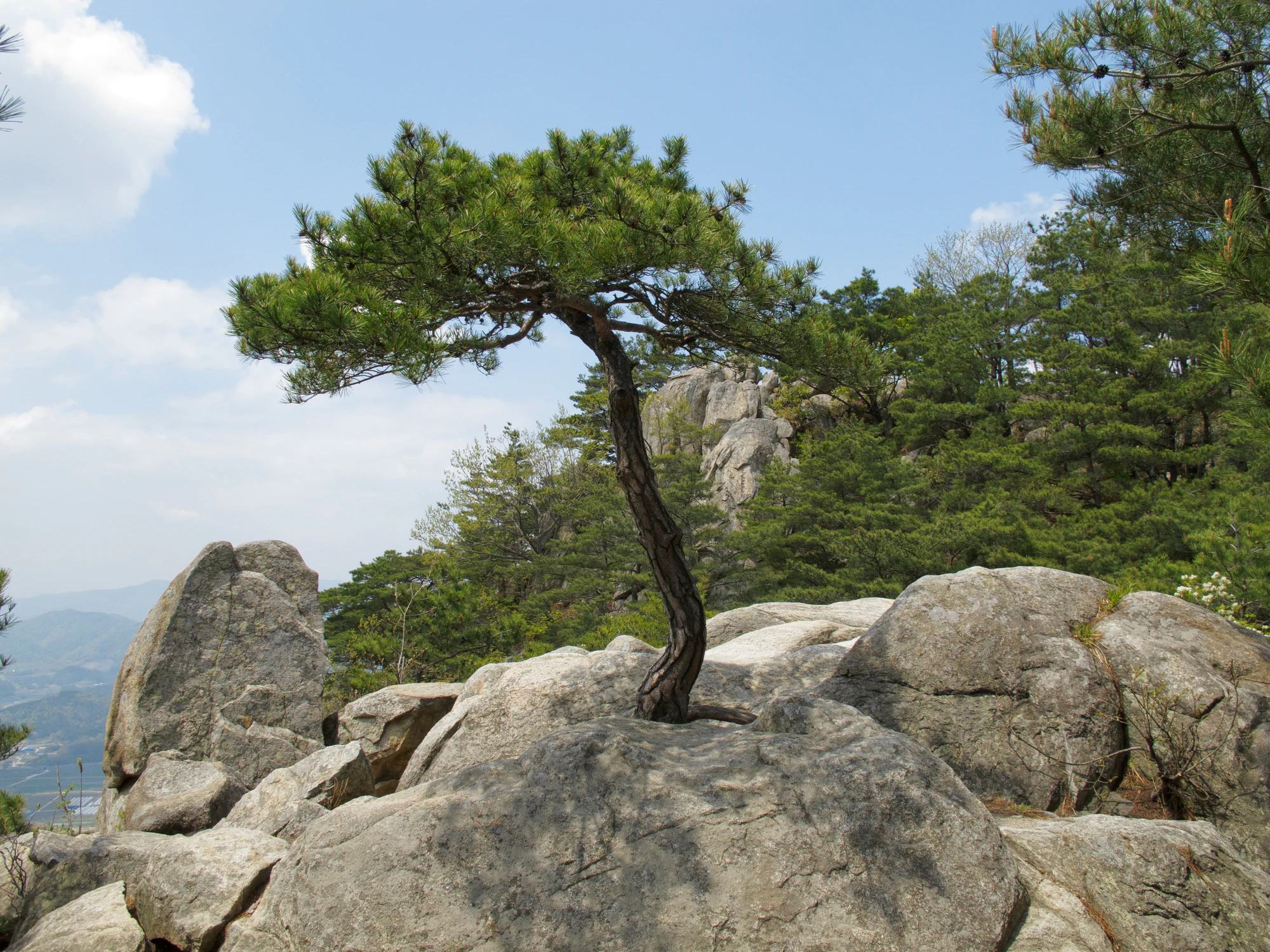
A curved pine grows between pale granite boulders on a wooded slope, with a hazy valley in the distance.

A curved pine among granite rocks in the Namsan district, photographed on 28 April 2011.

“IMG_0344.jpg” by Tom Page (tompagenet), CC BY-SA 2.0. Source: Flickr. No changes. · Creative Commons 1 · Creative Commons 2

Walks and routes

Samneung to Geumobong: the main Namsan walk

Follow the signed Samneung–Badukbawi–Geumobong route. KNPS divides the outward walk into 1.2 km to Badukbawi, about 1 hour, and a further 0.9 km to Geumobong, about 30 minutes. The lower section mixes stone paving and earth; stone stairs become prominent higher up. Beyond Badukbawi, the route follows the ridge on a mixture of rock, earth and wooden steps. Choose an out-and-back on the same marked trail for a straightforward first visit, about 4.2 km in total calculated from the published outward distance. Do not treat an unfamiliar descent into another valley as a shortcut back to your transport. See the official Samneung route description before setting out.

This is a mountain walk with steps and uneven footing. A gentle description of its overall gradient does not make the full route step-free.


Samneung to Geumobong: the main Namsan walk

Bulguksa to Seokguram parking: a forest approach

The official approach from Bulguksa to the Seokguram parking area is 2.2 km one way, with a published walking time of 50 minutes. Returning by the same route gives 4.4 km and roughly 1 hour 40 minutes of walking before rests. Visiting the grotto adds a separate 1.2 km return walk from the parking area, listed as about 30 minutes. Budget temple-viewing time separately. The full KNPS route called the Bulguksa Course continues much farther toward Bobul-ro; that longer one-way itinerary is not the short approach described here.

Wide stretches are interrupted by paving and stairs. KNPS warns about falling-rock sections and says the Bulguksa approach is unsuitable for wheelchairs or strollers.

Bulguksa to Seokguram parking: a forest approach

Seokguram parking to Tohamsan summit: a separate ascent

From the Seokguram parking area, KNPS lists 1.4 km and about 35 minutes to the summit. For the same-path return, allow around 2 hours including a pause at the top; this is an editorial allowance, not an operator promise. Check the weather before choosing the summit over a lower visit. Going to Seokguram itself and climbing Tohamsan are different branches of an outing, so check the signs rather than following visitors indiscriminately. Use the official Tohamsan district map to distinguish the junctions.

The operator describes an earth path with some steep sections. Mountain footwear and care on slippery ground are still necessary.

Seokguram parking to Tohamsan summit: a separate ascent

A short first visit

Start at Samneung, spend most of your time in the pine grove and around the tombs, then return to the same gateway. The suggested 45–75 minutes leaves room for photographs and reading the signs. Keep the visit at this level if anyone is unsure about uneven mountain steps; there is no need to turn a woodland stop into a summit commitment.

A half-day on Namsan

Arrive with water and your return journey settled. Walk uphill via the marked Samneung course, allowing stops at the Buddhist images without blocking the path. Reassess at Badukbawi before continuing to Geumobong, then return by the same route. Leave the afternoon flexible rather than booking a tight onward connection immediately after the hike.

Things to try

Photograph the pine grove without rushing the climb

Make the grove a destination in its own right. The city highlights the curved trunks and changing atmosphere in morning light, mist and snow. Look for a composition from an existing path rather than stepping among roots or onto a burial mound. If photography is the main reason for coming, reserve time here before deciding whether a summit adds anything to your day.

Ask about a ranger-led walk

Ask the park office whether nature-and-culture walks from the Samneung visitor-support centre are running on your visit date. A ranger-led visit can connect the trees and animals with the Buddhist remains along the trail. Confirm the meeting point, language and booking arrangements before relying on a session in your day’s plan.

Explore Silla indoors in the city

For persistent rain, switch to Gyeongju National Museum as a separate city visit. Its Silla history and art galleries add context to the tombs, temple sites and sculptures seen outdoors. Check the museum’s current notices and visiting information before travelling, since individual galleries and special exhibitions can have different arrangements. The museum is an alternative outing, not an indoor shelter along the Namsan trail.

Wildlife and habitats

Pine woodland at Samneung

At Samneung, the pines are part of the main experience rather than a species to hunt down. Notice their curved trunks and the way the canopy frames the tombs while staying on the paths. Their evergreen foliage gives a winter visit a different character from a walk through bare deciduous woodland.

Mandarin duck: a park flagship, not a promised sighting

The park’s animal flagship is the mandarin duck. KNPS describes its association with wooded valleys and water, but does not establish a reliable viewing spot on this Samneung itinerary. If you encounter waterbirds during a permitted visit, watch quietly from a path, keep your distance and never feed them or approach nesting cavities.

Stories and discoveries

Three tombs, with careful historical attribution

The city describes the Samneung tombs as attributed to Silla rulers Adalla, Sindeok and Gyeongmyeong. It presents these identities as historical identification rather than certainty. Reading the site panels before continuing uphill gives the pine grove a human history as well as a distinctive shape.

Seokguram is a constructed stone sanctuary

Seokguram is an artificial grotto built from granite, not simply a natural cave containing a statue. Its chamber, passage and sculptural programme are part of an eighth-century religious design. That makes it a rewarding counterpart to the outdoor rock-cut images on Namsan.

When to visit

Spring: blossom with a trail-status check

Tohamsan’s published route description highlights cherry blossom, but flowering dates vary. Combine a dry-weather forest walk with one temple visit, and check fire-season restrictions before adding a longer branch.

Summer: shorten the plan when necessary

Start early enough to avoid the hottest part of the day and carry sufficient water. Postpone valley walks in heavy rain; the Amgok route page specifically warns that streams can rise suddenly in the rainy season. Shade does not remove heat or flood risk.

Autumn: foliage or the Amgok grassland outing

Autumn offers Tohamsan foliage and the silver-grass landscape around Mujangbong on the separate Amgok course. KNPS lists Amgok as an 8.5 km course taking about 3 hours 30 minutes. Give that walk its own outing, consult its current map and access notices, and wear footwear suitable for its stone-and-gravel sections.

Winter: a woodland visit can be enough

Snow can transform the Samneung grove, but shorten the walk if footing is icy. Check conditions before attempting the mountain steps, and leave a generous daylight margin for the descent. A photograph of the grove does not require reaching the summit.

Getting there and practical advice

Use the gateway facilities before climbing

Gyeongju’s Samneung page lists parking and toilets. KNPS identifies Seonamsan Parking at 647 Poseok-ro for this gateway, and gives Samneung’s address as San 73-1, Bae-dong. These are useful arrival references; current parking charges and accessible-toilet details need checking on site. For route conditions and specific access questions, the national-park office number is 054-778-4100.

Mountain entry cutoffs

At Samneung visitor-support centre and the Seokguram park checkpoint, KNPS lists entry from 04:00 to 16:00 in April–October and from 05:00 to 15:00 in November–March. These are entry windows, not temple visiting hours or a recommendation to start a long walk near the cutoff. Tohamsan visitor-support centre has a separate restriction from sunset until two hours before the following sunrise; do not apply that exception to every Tohamsan trail. Check your exact gateway in the KNPS entry-time table and follow current closures and signs.

Travel to Samneung, not the park office

The city lists bus 500 to the Samneung stop, followed by about five minutes on foot. Treat that as a route lead and check the current direction, departures and return service in Gyeongju LIVE BUS on your travel day. If arriving by taxi or car, specify Samneung or Seonamsan Parking. The national-park office in Sinpyeong-dong is a different destination. Arrange the onward ride before committing to a trail with a different exit.

Match the visit to the whole group

For limited stamina, begin with the Samneung gateway and decide how far to proceed from the actual surfaces. For a wheelchair or stroller, ask specifically about a continuous route from parking or the bus stop, slopes, thresholds and toilet access. The fact that one part of a trail is wide or relatively level does not establish accessibility for the complete outing. Do not rely on carrying equipment up the mountain stairs as the default plan.

Sources and useful links

Wildlife you might spot

2

Each card links to a full Explore page with photos, traits, and fun facts.

Snap map for this place

Start with the big picture, then zoom in to explore individual wildlife observations around this place.

Loading map…

Good to know before you go

Take a photograph of the trailhead map and keep the official district map available offline. Junctions lead to different valleys and exits.

Wear shoes with a secure grip. KNPS specifically warns that wet rock and exposed roots on these routes can be very slippery.

Carry your own drinking water, a snack and a layer for stops; do not build the walk around an unverified spring or mountain shop.

Keep to marked paths around tombs, sculptures and temple remains. Do not climb on heritage stonework for photographs.

Choose your turnaround time before setting off and leave daylight for the descent and your onward transport.

Check the exact district and trail on the current control page. An old construction end date is not confirmation that a path has reopened.

Frequently asked questions

No. The Samneung grove and tombs make a worthwhile short visit. Decide whether to continue only after seeing the trail conditions and judging the group’s energy. A shorter visit is especially sensible when the steps are wet or the forecast is uncertain.
Plan them as separate destinations. They belong to different park districts, and this guide does not propose a connecting walking route. For a single half-day, choose Namsan or Tohamsan rather than losing time transferring between them.
Gyeongju’s visitor page lists admission to Samneung as free. This does not establish parking charges or the conditions at every temple and attraction elsewhere in the national park. Check those separately when choosing your day’s stops.
Reopening has not been confirmed. The 17 September 2026 notice extended construction control on Chuwonsa–Sureatjae–Yongyeon Falls through 5 October, but the park’s control page still showed partial control when checked on 18 October. Confirm directly with KNPS before attempting that segment.

Recent snaps at this place

Recent snaps will appear here as new observations are added.

View all ›

Take the discovery with you

Exploring Gyeongju National Park?

Identify the wildlife you spot, learn as you go, and keep a collection of the adventure.

  1. 1Spot it
  2. 2Snap it
  3. 3Keep the discovery




