
Snappit logo
Snappit
Get App
Generic illustration, not a photograph of this venueIllustration
ParkKR

Hallyeohaesang National Park

Hallyeohaesang rewards a slower itinerary.

About

Hallyeohaesang rewards a slower itinerary. A ferry crossing gives the islands depth; on land, a wooded path can suddenly open onto layers of headlands and sea. The park is dispersed across six districts rather than gathered around one entrance. Tongyeong–Hansan is a useful base for island walking, while Sangju–Geumsan offers a substantial mountain outing without a ferry. Geoje–Haegeumgang brings the cliffs closer, and Yeosu–Odongdo offers a causeway approach to coastal woodland.

Decide first whether the day is about hiking, heritage or a short sea-view walk. Then choose the access point, check that specific route and build the return journey around it. A boat ticket, a hiking reservation and a tide window solve different parts of an island visit. Unlock an interactive field guide for this spot: get the Snappit app to identify nature on the go.

Designated in 1968, Hallyeohaesang was Korea’s second national park and its first marine national park. Its cultural landscape includes Boriam on Namhae and the Hansando sites associated with Admiral Yi Sun-sin. Jeseungdang commemorates a naval headquarters site; the buildings seen today should not be mistaken for an untouched sixteenth-century complex.

What to do here

Climb Geumsan through rock formations to Boriam and the summit area, take the gentler Geumsan Nature Trail, or make Hansando your one-island walking day. In Geoje, the Ujebong route overlooks Haegeumgang; in Yeosu, Odongdo combines a seawall approach with wooded paths. Keep the other districts for another visit rather than spending the day crossing the whole coast.

Seasonal info

Summer humidity and heavy rain can make rocky paths slippery, while strong wind and waves can disrupt boats in any season. In winter, allow for shorter daylight and exposed viewpoints. A clear day inland does not establish safe sea conditions.

Accessibility

Choose by the exact approach. Ujebong and the Somaemuldo lighthouse route are walking routes with barriers to wheelchairs and strollers. A shorter approach from Bokgok’s upper parking area still does not make Boriam step-free. Odongdo’s seawall and central-square approach are worth discussing with the local office, separately from its hill paths and steps.

Don't miss

1

Geumsan’s rocky ascent, Boriam and sea-facing viewpoints

2

Hansando’s island ridges and Yi Sun-sin heritage

3

Haegeumgang’s sea cliffs viewed from the Ujebong area

4

Odongdo’s camellia woodland and mainland-linked approach

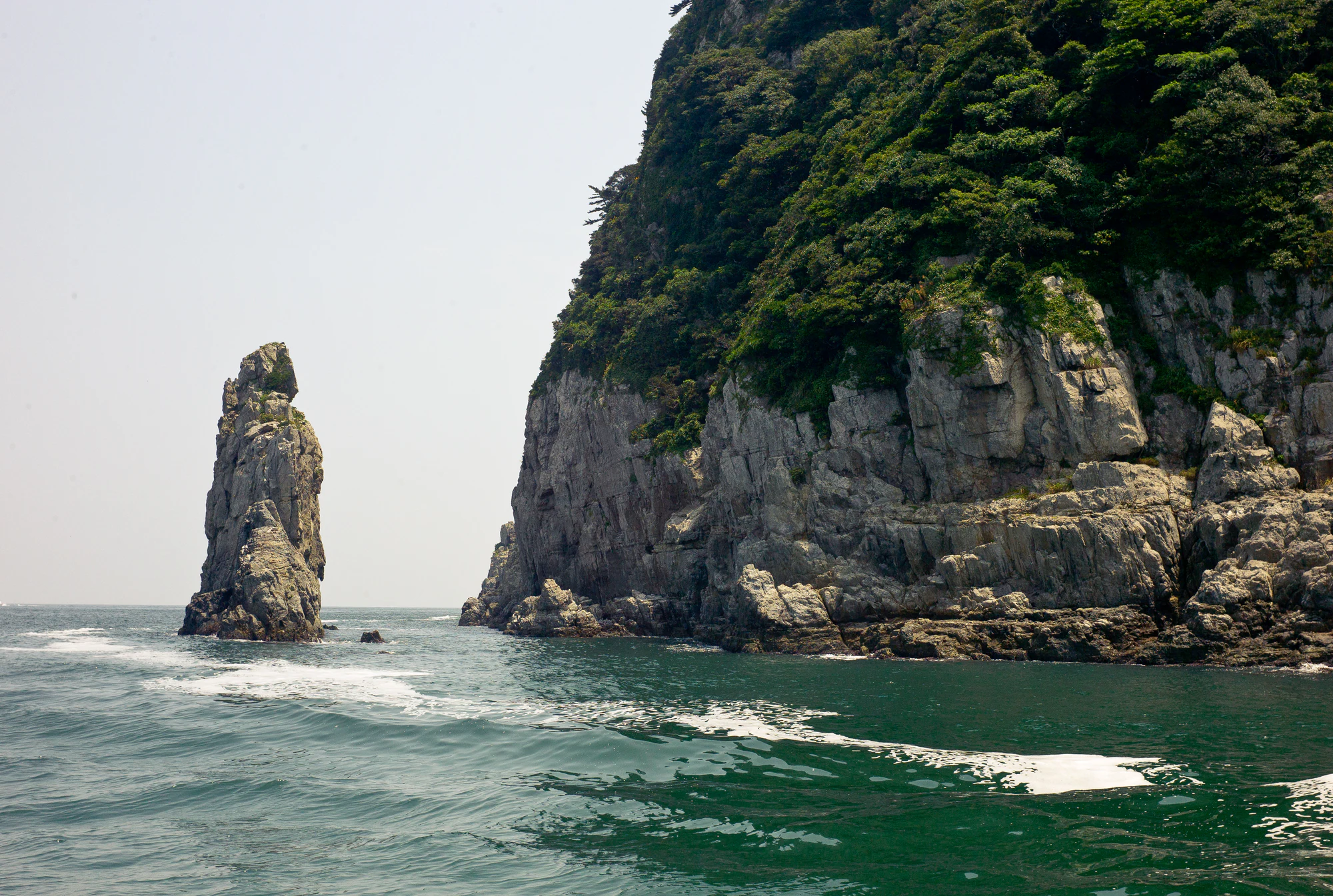
A narrow rock stack rises from the sea beside a larger wooded cliff, with open water in the foreground.

Sea cliffs and an offshore rock at Geoje Haegeumgang, photographed by Dylan Park on 23 July 2011. This historical view illustrates the park’s coastal landscape.

“거제 해금강” by Dylan Park (junezel), Flickr, CC BY 2.0. Unchanged original; no crop, resizing or re-encoding. · Creative Commons 1 · Creative Commons 2

Walks and routes

Geumsan Nature Trail

A 1.2 km return loop from the Geumsan entrance area, with an official allowance of about one hour. The loop entrance lies about 100 m above the support centre. Choose this for forest, interpretation panels and a modest walk when a summit climb would be too much. It returns to the entrance area rather than continuing to Boriam.

This is the gentler alternative, but the operator’s family-walk description is not a verified step-free rating. Ask the support centre about current surfaces and any assistance needed.

Geumsan Nature Trail

Geumsan Course 1: entrance to summit

The official 2.2 km ascent runs from Geumsan Visitor Support Centre through Doseonbawi, Ssanghongmun and Boriam to the summit. KNPS gives 1 hour 30 minutes uphill; allow additional time for the descent, the temple and views. The first 1.7 km climbs steep, stony ground to Ssanghongmun; the remaining 0.5 km includes decks and railings. This is the choice for a real mountain walk.

Steep stones make the lower ascent unsuitable for wheelchairs or strollers. The Bokgok upper-parking approach reduces climbing, but ask about stairs and parking restrictions before using it as an accessibility alternative.

Geumsan Course 1: entrance to summit

Hansando: Jindu–Mangsan–Deopeulgae

KNPS lists this 7.2 km point-to-point walk at about 3 hours 30 minutes. It crosses Mangsan for island-and-sea views, finishing at Deopeulgae rather than returning to Jindu. Treat it as the main activity of the day. Arrange transport between the ferry arrival point and both trail ends before boarding; a ticket to Jeseungdang does not deliver you to Jindu.

The trail includes slopes and stairs. Carry what you need for the walk, and do not assume a continuous paved coast path or a vehicle pickup at the finish.

Hansando: Jindu–Mangsan–Deopeulgae

Ujebong: Haegeumgang–Seokgae Beach

The published route leads from the Haegeumgang parking area through Ujebong to Seokgae Beach: 1.5 km and about 40 minutes of walking. The viewpoint frames the sea cliffs and offshore rocks, making this a compact Geoje choice when you want coastal scenery from land. Give yourself extra time at the viewpoint and establish your return to the parking area.

KNPS explicitly rules out wheelchair and stroller passage. Remain on the designated route; cliffs lie beyond it.

Ujebong: Haegeumgang–Seokgae Beach

Odongdo: seawall and woodland

Walk the 768 m seawall from the mainland entrance, then choose how much of the island’s wooded path network to explore. The city describes 2.5 km of nature paths, not a compulsory loop to add to every visit. The central-square approach suits a shorter outing; hill paths bring a different angle on the coast. Allow roughly 1½–2½ hours for an unhurried visit, depending on your route and stops.

Separate the broad seawall and square approach from the hill paths and stairs. Confirm suitable access and transport operation locally; no full-island step-free route is promised.

Odongdo: seawall and woodland

One day based in Tongyeong

Check the outward and return Hansando sailings, then travel to the passenger terminal. If the island transfers work, make Jindu–Mangsan–Deopeulgae the main walk and retain a generous connection margin. If they do not, choose a shorter Jeseungdang heritage visit instead. Return to Tongyeong without adding a second island merely to fill the afternoon.

A land-based day on Namhae

Start at Geumsan’s lower entrance for the summit ascent if everyone is comfortable on steep stones. Allow time for Boriam and the descent. For a lighter day, take the nature loop and enjoy lunch locally. The Bokgok approach is a separate access choice to confirm in advance, rather than an assumed shuttle connecting the two plans.

Things to try

Make the island crossing part of the day

For a first Tongyeong visit, choose Hansando and keep the schedule simple. Decide between the Mangsan walk and a shorter heritage-focused outing around Jeseungdang. Trying to combine a ridge traverse, an unplanned island bus transfer and a second island leaves little margin if boats change. Photograph the sea from safe public viewpoints or the permitted passenger area of your boat.

Read the coast through its rocks

Ujebong offers a land-based view toward Haegeumgang. At Odongdo, Yeosu identifies wave-cut landforms including Yonggul Cave and Baramgol gorge in Cretaceous sedimentary rocks rich in volcanic material. Look from the maintained route; a geological feature named on a visitor page is not an invitation to descend an unmarked cliff or enter the water.

When the sea or trail changes the plan

If a ferry is cancelled, keep the day on the mainland rather than driving to another harbour in search of an escape from the same weather. If it is merely a damp, settled day and paths remain open, choose a short signed walk suitable for your footing. During strong wind, heavy rain or a thunderstorm, postpone cliff paths and summit outings. Check reopening information before resuming the original plan.

Wildlife and habitats

Eelgrass

Eelgrass (Zostera marina) is a marine flowering plant. Here, the supported association includes restoration plantings monitored after work carried out in 2017–2024. Treat it as habitat to learn about rather than a guaranteed sighting from a named walk. Stay out of planting areas and avoid trampling or collecting seagrass.

Stories and discoveries

A marine park has an underwater landscape too

Eelgrass is one of Hallyeohaesang’s conservation flagships. Its long leaves form shallow-water habitat that supports other marine life. The park’s 2025 monitoring specification follows earlier restoration plantings; it shows active care for an ecosystem that a summit photograph cannot reveal.

When to visit

Flowers, shade and autumn light

Odongdo’s camellias are a late-winter-to-spring focus; flowering varies with the year. On Geumsan, KNPS highlights April–May wildflowers and October–November colour. Summer visitors should start with heat, rain and sea forecasts rather than a fixed checklist. In colder months, carry an extra layer for exposed viewpoints and bring the return journey forward as daylight shortens.

Getting there and practical advice

Use the right local contact

For western sectors including Namhae and Sacheon, KNPS lists 055-860-5800. For Tongyeong and Geoje, the eastern office is 055-640-2400; the 2026 Ujebong reservation notice gives 055-640-2445 for questions. Odongdo’s city visitor contact is 061-659-1819. Ask about your named route, not simply whether “the park” is open.

Parking and supplies

Tongyeong Passenger Terminal has paid parking. At Boriam, distinguish Bokgok parking areas 1 and 2 before setting navigation; permission to continue uphill and any shuttle arrangements should be checked for your visit. Carry your water and walking supplies before leaving the town or trailhead.

Tongyeong to Hansando

Use Tongyeong Passenger Terminal at 234 Tongyeonghaean-ro. The ferry operator describes a local-bus approach from the intercity terminal via Seoho Market, followed by a short walk; confirm the current service rather than relying on an old route number. Select Hansando’s Jeseungdang arrival explicitly if that is your destination. Check the sailing date, return pier, identification rules, fares and island transfers together. The operator’s published contact for the terminal is 055-641-5366.

Namhae and Yeosu without a ferry

For Geumsan’s lower trailhead, KNPS describes a Sangju-bound local bus from Namhae Intercity Bus Terminal to Geumsan entrance. Confirm the day’s departures and your return connection. Odongdo is reached from the mainland over its seawall, so no ferry ticket is needed for the island walk. Its Dongbaek tourist train is an optional service to check locally, not a prerequisite for entry.

Confirm the full journey

For a visitor using a mobility aid, ask about the path, the pier and the vessel separately. A relatively gentle island path does not establish accessible embarkation. Request details about boarding assistance, ramps, toilets and steps for the exact sailing and walking section. For mixed-ability groups, plan a shorter shared route rather than assuming everyone can meet beyond a steep descent.

Visitor information

Access update checked 18 October 2026

The 13 October notice keeps two sections closed: Somaemuldo’s Yeolmokgae crossing toward the lighthouse island, and Gonggoji–Seoimal junction in Geoje. Do not enter either section until KNPS announces reopening. These restrictions are separate from Ujebong’s seasonal reservation requirement.

Access update checked 18 October 2026
Sources and useful links

Wildlife you might spot

1

Each card links to a full Explore page with photos, traits, and fun facts.

We are still adding species preview cards for this place.

Snap map for this place

Start with the big picture, then zoom in to explore individual wildlife observations around this place.

Loading map…

Good to know before you go

Book the return boat before committing to a long island walk, and carry the identification required by your carrier.

Save the Korean names of both your departure pier and arrival pier. “Hansando” alone is not a complete transfer plan.

Bring drinking water, a snack, sun protection and a windproof layer; do not depend on a shop at a trail junction.

Wear shoes with grip for rocky slopes and stairs, even on a route with a short published distance.

Keep clear of cliff edges and closed paths. An attractive rock ledge is not a designated viewpoint.

At Boriam and memorial sites, leave room for worshippers and other visitors; keep photography quiet and unobtrusive.

Frequently asked questions

No practical one-day route covers its six dispersed districts. Choose Tongyeong–Hansan, Namhae, Geoje or Yeosu as a base and give that area time. The park name covers the whole protected place; it is not a single attraction with one gate.
Do not plan the crossing under the restrictions checked on 18 October 2026. KNPS’s 13 October notice closes Yeolmokgae after storm damage. Low tide does not override that closure. After an official reopening, check both the permitted crossing window and the return ferry before setting out.
For 1 October–30 November 2026, KNPS requires reservations for Haegeumgang–Ujebong–Seokgae Beach. The announced visiting window is 10:00–15:00, with last entry at 14:00 and capacity of 370 visitors a day. Check the current notice and booking system for later dates; do not assume these seasonal conditions are permanent.
Plan separate costs for ferries, parking and any attraction-specific admission or shuttle. Namhae County lists an adult Boriam admission charge of KRW 1,000 on its older information page; confirm the current amount and upper-parking access before travel. A park visit does not include boat transport.

Recent snaps at this place

Recent snaps will appear here as new observations are added.

View all ›

Take the discovery with you

Exploring Hallyeohaesang National Park?

Identify the wildlife you spot, learn as you go, and keep a collection of the adventure.

  1. 1Spot it
  2. 2Snap it
  3. 3Keep the discovery
