
Snappit logo
Snappit
Get App
Generic illustration, not a photograph of this venueIllustration
ParkKR

Igidae Park

Igidae rewards a slower pace than its modest distance suggests.

About

Igidae rewards a slower pace than its modest distance suggests. The path rises and falls around the coast, so a viewpoint, a flight of steps and a patch of woodland can change the scene within a few minutes. Choose your turning point before setting off rather than treating the far end as an obligation.

For a first visit, the northern section is a sensible introduction. If everyone is comfortable with steps and heights, and the weather is settled, continue south past the named rock formations. A one-way walk gives you more new scenery, but it also needs a separate journey home. Decide that part while you still have a good signal and plenty of daylight. Planning to visit? Download the Snappit app to identify the wildlife you spot in real-time.

The name Igidae has more than one traditional explanation. Busan’s history account cites an 1850 record linking it with two gisaeng graves, and also recounts a story of women who drew a Japanese commander into the sea during the invasions of Korea. Treat these as accounts of the name’s origins, not a settled reconstruction of an event. The area was later restricted for military use and opened to civilians in 1993. That opening date is different from the city’s listed park-designation year, 1986. The two dates describe different changes in the life of the place.

What to do here

Walk a signed coastal section, pause at Eoulmadang, and use the geology panels to make sense of the rocks. The shoreline itself is the attraction; there is no need to descend onto wave-washed ledges to appreciate it. A guided geology walk is a good choice if you would like help reading the landscape.

Seasonal info

The sea and rock scenery are the main draw throughout the year. Summer humidity can make the repeated climbs tiring; winter wind can make an apparently mild day feel cold on an exposed crossing. Leave a daylight margin rather than relying on lighting along the whole coast.

Accessibility

The coastal route includes steps, climbs and exposed footbridges. It should not be planned as a continuous wheelchair or stroller route. Accessible parking or toilet symbols do not establish step-free access between viewpoints; ask about the exact approach you intend to use.

Don't miss

1

Cliff-edge paths with the sea close below

2

A pause at Eoulmadang facing the Busan skyline

3

Nongbawi and other named coastal rock formations

4

Volcanic rocks shaped by waves and uplift

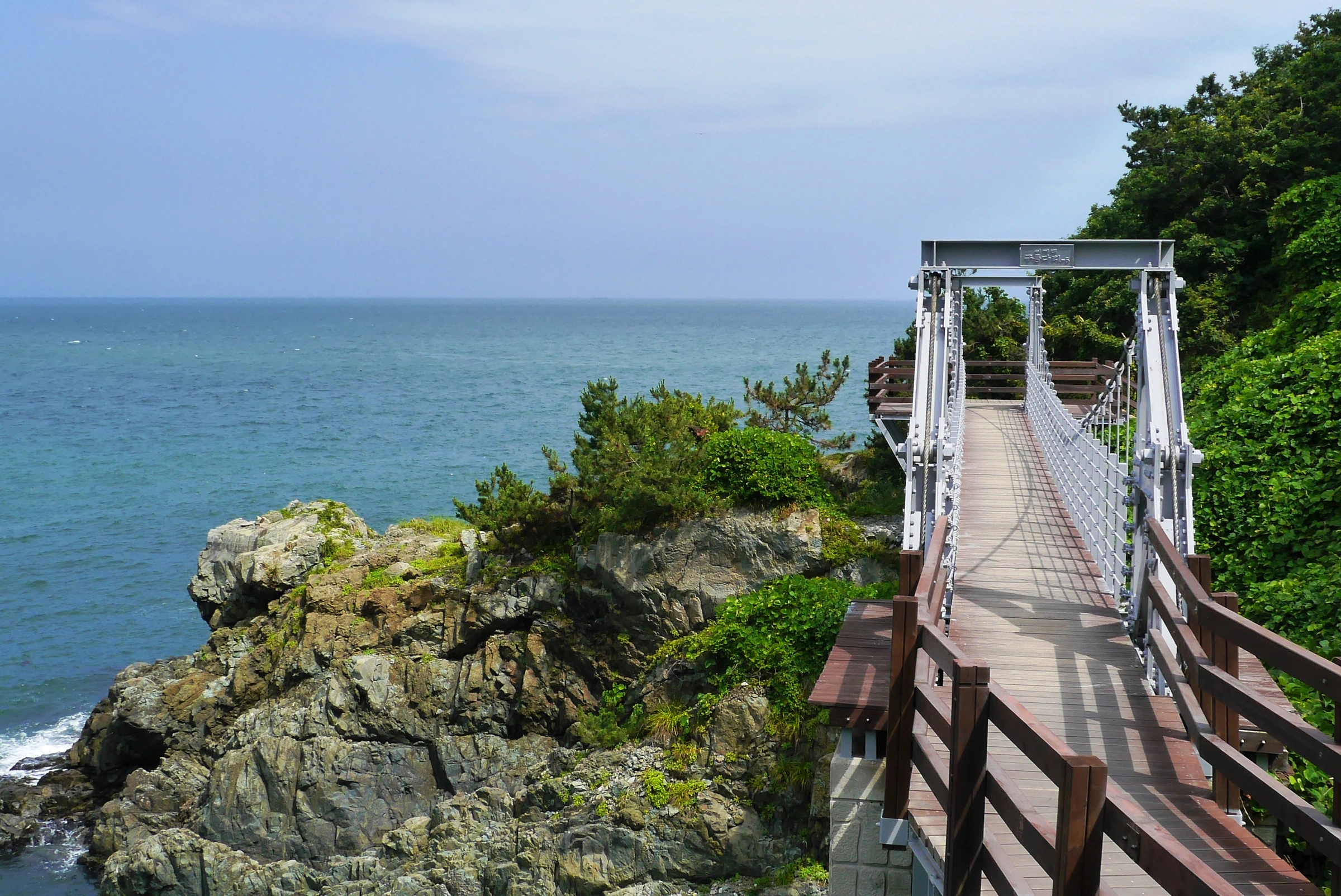
An empty suspension footbridge and wooden approach stand beside a rocky, green coastal slope and open blue sea at Igidae.

A footbridge beside Igidae’s rocky coast, photographed on 4 July 2014. This historical image shows the character of the path, not today’s bridge condition or access.

“Busan | Igidae Coastal Trail” by travel oriented, via Flickr, CC BY-SA 2.0. No changes. · Creative Commons 1 · Creative Commons 2

Walks and routes

Dongsaengmal to Oryukdo Haemaji Park

Busan Geopark publishes this sequence: Dongsaengmal → Eoulmadang → Nongbawi → Oryukdo Haemaji Park, 3.95 km with an average walking time of two hours. It is a one-way course. Use the named destinations on the signs and allow extra time for pauses rather than trying to maintain the published average.

Repeated changes of level and coastal exposure make this a walking route for visitors comfortable with steps. The final park is a mainland endpoint; no island crossing is involved.

Dongsaengmal to Oryukdo Haemaji Park

Longer itinerary to Oryukdo ferry landing

Visit Busan gives Dongsaengmal → Eoulmadang → Nongbawi → Oryukdo ferry landing as 4.7 km and about 2½ hours. Choose this only if you want the extra mainland endpoint. The sources do not explain their measuring methods, so subtracting 3.95 from 4.7 does not establish the length of a connecting segment.

A longer finish adds walking after the main coastal section. Save energy for the exit and onward transport; arrival at the landing does not imply a boat service is running.

Longer itinerary to Oryukdo ferry landing

A shorter Dongsaengmal–Eoulmadang outing

For a flexible visit, follow the open coastal path from Dongsaengmal toward Eoulmadang, then return the way you came. The official guided programme uses this named northern section in the opposite direction. Our 60–90-minute allowance is a suggestion for an unhurried outing, not an official round-trip time or a measured route length. Turn earlier if that suits the group.

Shortening the route does not remove its bridges and steps. Make the first uncomfortable section your turning point rather than pushing on to reach a named landmark.

A shorter Dongsaengmal–Eoulmadang outing

A gentle first look at your own pace

Keep the first visit simple: arrive at Dongsaengmal, read the route board and begin the northern section. Aim for Eoulmadang only if the steps feel comfortable, then retrace your route. Leave time for the approach from your arrival point and for a break afterward. A suggested 60–90 minutes on the coastal outing is enough to avoid turning a short visit into a race.

A walking-focused half-day

Start with water, a snack and a checked onward journey from the Oryukdo side. Follow the coastal route south, pause at Eoulmadang and continue toward Nongbawi if conditions remain comfortable. Choose the Haemaji Park or ferry-landing finish in advance. Budget roughly 2½–3 hours for walking and stops, with additional time for transport. If the forecast worsens, use an earlier turnaround instead of trying to rescue the original schedule.

Things to try

Let a guide explain the rocks

The city’s 2026 geology programme lists 90-minute departures at 10:30 and 14:00 from the Igidae information centre, 107 Igidaegongwon-ro. It normally runs Tuesday–Sunday, with exclusions including rain, air-quality warnings and holiday periods. The listed minimum is elementary-school grade 3; primary-school children need an accompanying guardian. Reserve a dated session through the official booking page, check the language offered, and read its cancellation and photography notice before submitting. This is an organised activity, separate from ordinary park admission.

Make Eoulmadang your deliberate pause

Eoulmadang provides a broader resting place along a route otherwise punctuated by stairs and narrow sections. Face the water, have the snack you brought, and decide whether the remaining walk still suits everyone. For photographs, include some nearby rock or vegetation with the distant skyline rather than leaning beyond a railing for an unobstructed view.

Save the exposed coast for better conditions

Rain is a reason to reconsider the route, not to find an unofficial shoreline shortcut. The organised geology programme also excludes rainy days. If conditions are poor, postpone the walk or make a separate indoor plan in Busan; do not assume that the proposed art-park buildings provide shelter or an open exhibition.

Wildlife and habitats

Japanese black pine

A coastal-forest study published in 2007 recorded Japanese black pine, Pinus thunbergii, as a dominant canopy tree at Igidae and the other named survey sites. Look at the wooded slopes as part of the coastal landscape, while remembering that this is a historical record rather than a promise about today’s trees. The study also named Ficus erecta in Igidae’s lower tree layer. Enjoy any plants from the path and leave cones, leaves and fruit in place.

Stories and discoveries

The hollows are not dinosaur footprints

Some older descriptions refer to dinosaur tracks, but geological research identifies the rounded hollows in Igidae’s volcanic breccia as marine potholes formed by erosion. A nearby sea cave now above the active shoreline also helps tell a story of changing land and sea levels. Read the interpretation panels from the maintained path; there is no need to scramble into a cavity.

A coast built by fire, then reshaped by water

The city describes rocks created by intense volcanic activity around 80 million years ago. Later wave action and uplift helped produce the cliffs, rock platforms and caves seen today. Igidae is one geological site within the wider Busan geopark, while the municipal park has its own management boundary. Those two labels describe different things.

When to visit

Warm days

Carry enough water for the whole chosen route and plan a shaded pause before anyone feels depleted. A light layer is still useful when a coastal breeze picks up. After heavy rain, choose another day if boards, steps or access notices make the walk doubtful.

Cool days and changing weather

Bring a wind-resistant layer and keep the visit within comfortable daylight. Shorten the plan if visibility drops, gusts become uncomfortable or spray reaches the route. A good view is not worth continuing along an exposed section in worsening conditions.

Getting there and practical advice

Admission, parking and basic facilities

The tourism listing describes free general admission and paid public parking, and shows accessible-parking and accessible-toilet symbols. It does not identify a continuous accessible coastal route. Before leaving your arrival area, locate the toilet you intend to use and check the posted parking tariff and closing arrangements. Carry what you need rather than relying on a shop midway along the cliffs.

Treat new cultural facilities as plans until confirmed

Busan’s art-park programme sets out several phases of development, including proposed galleries, pavilions and a wooden lookout. The plan is not a list of facilities already open. For a dependable visit, make the coast your main activity and check any particular new attraction separately; obey work-zone signs if you encounter them.

Choose an endpoint before choosing transport

Metro Line 2’s Kyungsung University–Pukyong National University station is the transfer point named by Visit Busan. From there, check a current bus or taxi route to Dongsaengmal for the northern start, or to the Oryukdo mainland area for a reverse walk. Search the specific endpoint, not simply “Igidae”, which may place you at another park approach. Bus routes, stops and final walking approaches need a same-day check.

Keep the return journey realistic

A car works most simply with an out-and-back. For a through-walk, arrange the return from the other end before leaving the car, or use public transport for the whole outing. Do not assume that a roadside exit halfway along the coast is short, easy or available just because it appears close on a map.

Plan around the least comfortable walker

This is a coastal hill walk with stairs, rather than a level waterfront circuit. A stroller can become a burden on the repeated changes of level. For a wheelchair user or anyone needing step-free access, ask about the specific viewpoint, parking bay and toilet connection before travelling. Visit Busan lists 051-607-6398 for park enquiries; confirm the approach’s gradients and surfaces for your needs. For mixed groups, agree on a shared turnaround and avoid leaving someone waiting alone at a remote junction.

Sources and useful links

Wildlife you might spot

1

Each card links to a full Explore page with photos, traits, and fun facts.

We are still adding species preview cards for this place.

Snap map for this place

Start with the big picture, then zoom in to explore individual wildlife observations around this place.

Loading map…

Good to know before you go

Wear shoes with a firm grip; wet boards and stone can be slippery.

Carry drinking water and a snack before joining the coastal path.

On narrow crossings, pause for photographs at a wider safe spot and keep the passage clear.

If driving, remember that a one-way coastal walk finishes away from your car.

Turn back at a barrier or unsafe surface; the shoreline is not a bypass.

Frequently asked questions

No. A short distance can still involve repeated climbs and descents. Choose the northern section if you want a flexible turnaround, and stop before anyone in your group becomes tired or uncomfortable with the exposure.
Use the figure that matches your endpoint. Busan Geopark’s 3.95 km course ends at Oryukdo Haemaji Park; Visit Busan’s 4.7 km itinerary ends at the ferry landing. Their measurement methods are not supplied, so do not treat the difference as a measured final leg.
You can combine the coastal walk with the mainland Oryukdo viewing area if conditions and time allow. The offshore islands are a separate place; this walking guide does not include island access or a boat trip.
Visit Busan lists the general coastal walk as free and normally open without fixed admission hours. That does not override weather closures or work barriers. The organised geology programme has a separate booking process.

Recent snaps at this place

Recent snaps will appear here as new observations are added.

View all ›

Take the discovery with you

Exploring Igidae Park?

Identify the wildlife you spot, learn as you go, and keep a collection of the adventure.

  1. 1Spot it
  2. 2Snap it
  3. 3Keep the discovery
