
Snappit logo
Snappit
Get App
Generic illustration, not a photograph of this venueIllustration
ParkRegión de Murcia, Spain

Sierra Espuña Regional Park

Sierra Espuña is a mountain forest with a human story running through it.

About

Sierra Espuña is a mountain forest with a human story running through it. Pines cover slopes that were badly depleted by centuries of use, while stone walls, water channels and old forestry buildings show how people helped the woodland return. The pale limestone above the trees makes a striking contrast with the dry country around the range.

For a first family visit, concentrate on the Ricardo Codorníu visitor centre and the Huerta Espuña–Fuente del Hilo area. The centre introduces the park’s wildlife, geology and restoration work through models, interactive displays and sensory interpretation. Confirm that it is open before building your day around the exhibition; the opening notice below explains what to check.

Outside, the one-kilometre accessible path towards Fuente del Hilo gives you a manageable way into the forest. Slow down at the view over Huerta Espuña, compare leaves and cones, and listen before moving on. It is a linear path, so a return to the same starting point doubles the distance. The longer Ricardo Codorníu circuit shares the name but adds steps and a road crossing; choose it deliberately rather than assuming every sign leads along the accessible option.

Families wanting another woodland walk can consider the Senda del Dinosaurio from La Perdiz. Its interest is the living forest, the ravine and the traces of water management. The official leaflet describes a suspension bridge and warns that the route is not continuously waymarked, so take the leaflet and ask about the crossing before setting off.

The full park extends into Alhama de Murcia, Mula and Totana. Higher viewpoints, the snow wells and longer mountain routes deserve a separate plan. You can understand a great deal about Espuña without reaching a summit: a quiet morning around the historic forest is a satisfying visit in its own right. Be ready to snap and learn! Get the Snappit app to identify any nature species you find here.

By the late nineteenth century, heavy use of Sierra Espuña’s woodland had left extensive bare slopes and serious erosion. Restoration work began in 1891 under forestry engineers Ricardo Codorníu, José Musso and Juan Ángel de Madariaga, supported by many workers. Tree planting went alongside measures to hold soil and slow water, rather than being a simple exercise in covering the mountain with pines. Huerta Espuña became a centre of that work. Elsewhere in the mountains, the snow wells tell an older story: winter snow was stored to provide ice for nearby towns before mechanical refrigeration. The park was designated a natural park in 1978 and a regional park in 1992. Protection and management continue to evolve, including a new management framework and a localized boundary change in 2026.

What to do here

Choose one walk around the Ricardo Codorníu centre: the accessible linear path to Fuente del Hilo, or the longer SL-MU 1 circuit if steps suit everyone. Add the exhibition when opening is confirmed. For a different half day, start the Senda del Dinosaurio at La Perdiz and use its official self-guided leaflet.

Seasonal info

Shade does not remove summer heat or fire risk. Rain can make natural paths and the ravine crossing unsuitable; snow and ice can close mountain approaches in winter. Follow current notices and barriers. January–June nesting restrictions affect specific upper-park areas, so check them before adding a longer route.

Accessibility

The park documents a one-kilometre linear path between the visitor centre and Fuente del Hilo with a surface intended for wheelchairs and pushchairs. Ask about its present condition, gradients, crossings and return arrangements. The full SL-MU 1 circuit includes a long stairway, while the Senda del Dinosaurio has a bridge and sloping natural ground. The centre has adapted facilities, but these depend on the building being open.

Don't miss

1

A short forest visit around Huerta Espuña and Fuente del Hilo

2

The story of the people who restored the mountain woodland

3

A choice between an accessible linear path and more varied woodland walks

4

Limestone scenery and the old water-management features of the Leyva valley

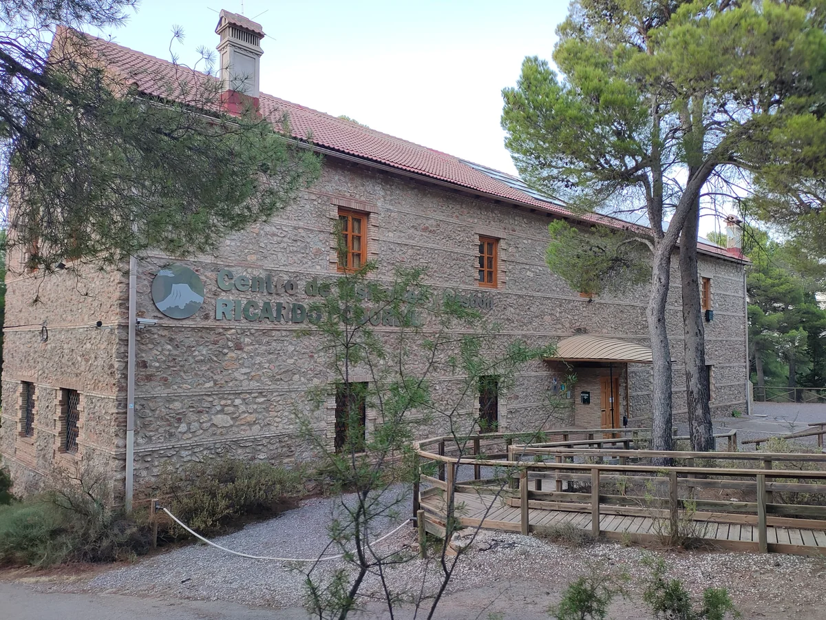
Stone visitor-centre building among pines, with a wooden approach ramp and the Ricardo Codorníu name on its wall.

The Ricardo Codorníu visitor centre in Sierra Espuña, photographed in September 2022.

Centro de Visitantes y Gestión Ricardo Codorniu. Sierra Espuña.jpg — Lorenzo Soriano / Wikimedia Commons / CC BY-SA 4.0 · Creative Commons

Walks and routes

Accessible Ricardo Codorníu path to Fuente del Hilo

This is the simplest woodland choice. The designated surfaced path links the centre with Fuente del Hilo and includes interpretation panels, a resting bench and a view over Huerta Espuña. Treat the lookout as a pause rather than a distance target: turning back early is perfectly reasonable. If you arrange a pickup, confirm the exact parking place at Fuente del Hilo beforehand.

The park’s accessibility inventory describes a wheelchair- and pushchair-suitable surface and reserved parking at both ends; the tourism authority also records a guiding strip. Ask about gradients, road crossings, temporary obstructions and the current state of the surface. Return along the accessible alignment rather than joining the stepped circular trail.

Ricardo Codorníu visitor centre

Accessible Ricardo Codorníu path to Fuente del Hilo

SL-MU 1: the full Ricardo Codorníu circuit

The published circuit passes the Codorníu monument, crosses the road towards the forestry house at Huerta Espuña, follows the old water-channel setting towards Fuente del Hilo, then climbs a long stairway by the restaurant area to Campamento de Exploradores. It returns towards the monument and centre. The buildings and water works make this a good walk for understanding how the forest was managed; do not assume the buildings themselves are open.

Choose this only if everyone can handle steps, slopes and a road crossing. The route’s shared name with the accessible path can be misleading: the full loop is not the wheelchair or pushchair recommendation.

Ricardo Codorníu visitor centre

SL-MU 1: the full Ricardo Codorníu circuit

Senda del Dinosaurio from La Perdiz

This self-guided outing links La Perdiz with the Leyva valley forest track. It introduces Mediterranean woodland, views into the ravine, a former water-supply system and stone structures built to hold soil and sediment. The leaflet describes a suspension bridge across the ravine followed by an uphill section. Carry the official leaflet: it explicitly says that the route is not waymarked throughout, although its first section overlaps PR-MU 57.

The brochure calls it low difficulty for walkers. Natural surfaces, the bridge and the climb make it a different choice from the accessible path. It is not the suggested wheelchair or pushchair route; an adult should check that all children are comfortable with the crossing.

La Perdiz recreation-area parking

Senda del Dinosaurio from La Perdiz

A gentle morning in the historic forest

After confirming access, spend about half an hour in the centre if it is open. Take the accessible path at your own pace, pausing over Huerta Espuña and turning back whenever it suits the group. Return to your starting point for a picnic or a prearranged meal. Allow 2–3 hours overall, or longer if you use the full out-and-back path and take generous rests.

A woodland half day with a bridge

Choose the Senda del Dinosaurio as the day’s main walk. Check its current condition, download the 2025 leaflet and start at La Perdiz. Allow 1½–2 hours for walking and stops, followed by lunch or a picnic. Add the centre only if it is open and the group still wants more; there is no need to complete both woodland circuits.

A short visit when energy is limited

If the centre confirms opening, make the exhibition your main stop and add only a brief section of the accessible path. A single view and a quiet listen can be enough. If the building is closed, decide in advance whether a short outdoor-only visit meets your needs, particularly for toilets and mobility support.

Things to try

Find the clues to a recovered forest

Look for the relationship between trees, slopes and stonework. On the Dinosaurio walk, the leaflet explains how low stone barriers retained soil on slopes and how larger structures caught sediment in ravines. Ask children which would help a seedling stay rooted after rain; observe from the path without climbing the walls.

Try a one-minute listening stop

Choose a safe place beside the path and pause together. Count different sounds rather than trying to name every bird: needles moving, wings, calls or distant human activity. Compare what you hear in a sheltered patch with a more open spot. Keep the experiment quiet so other visitors and wildlife can enjoy the same space.

Compare the woodland at eye level

Look at a pine’s needles and cones, then the smaller leaves of the shrubs below. Why might a plant in a dry summer keep its leaves tough or small? Use the interpretation panels to test your ideas. Photograph details in place rather than picking a collection to take home.

Save the high country for a separate day

The snow wells and upper viewpoints add a different layer of history and scenery. They also mean more mountain driving, more exposure and a fresh route choice. Ask for a suitable current itinerary rather than extending the short woodland plan without checking daylight, weather and the group’s energy.

Use the exhibition only when confirmed open

If conditions allow safe travel and the centre confirms opening, focus on the exhibition and audiovisual material. You can explore the restoration story without committing to a slippery woodland circuit. Have an alternative in town if the mountain visit cannot go ahead.

Keep the mountain visit flexible

In heavy rain, strong wind, snow or an access closure, postpone the outing. Read the official self-guided leaflet beforehand and let children choose a forest detail to look for on a better day. Avoid entering water mines, abandoned buildings or ravines to salvage the plan.

Wildlife and habitats

Aleppo pine: the woodland’s starting point

The park’s forest is dominated by Aleppo pine, much of it connected with the restoration programme. Notice the canopy, fallen cones and the patches of light reaching the understorey. The forest’s planted history is part of its story; it does not make every tree the same age or every pine the same species.

Mastic: look below the canopy

Mastic is one of the Mediterranean shrubs documented beneath the park’s pines. Look for its evergreen leaves along the permitted paths, using signs or a field guide to confirm identification. Leave any fruit on the plant and do not taste wild plants.

Crossbill: watch the pine crowns

If a small flock is working through the upper branches, take a closer look with binoculars. Crossbills use their crossed bill tips to open cones; adult males can look reddish and females greenish. They move in response to food, so linger where cones are plentiful and let your binoculars do the searching.

Raptors: part of the wider mountain story

Golden eagle and Eurasian eagle-owl are documented conservation species here. Enjoy a distant bird from an existing path or viewpoint, or learn about it in the centre. Do not seek nest sites, use playback or turn an owl search into a night-time excursion with young children.

Wild boar: give it room

Wild boar are part of the park’s woodland fauna. If one appears, stop at a distance and allow it a clear way out; keep children close and your dog on a lead. Keep food packed away and leave scraps out of reach. A chance encounter should stay on the animal’s terms.

Let wildlife set the pace

These are species documented in the park, not a checklist to complete in one visit. Season, weather and chance shape what you notice. Watch quietly from permitted routes and leave nests, roosts and resting animals undisturbed.

Stories and discoveries

A green mountain with little running water

The forest can feel surprisingly green, yet surface water is scarce and many springs or channels are intermittent. The old Caño de Espuña and the water works described on the Dinosaurio walk help explain why managing each supply mattered. Carry your own drinking water.

The restoration was a team effort

Ricardo Codorníu gives his name to the centre, but the restoration also involved José Musso, Juan Ángel de Madariaga and many workers. Thinking about all those people changes the view: the woodland is also a landscape of sustained work and practical experimentation.

Snow once had a working life

The higher snow wells stored winter snow for the towns’ ice supply. They connect a mountain landscape with everyday life far below it, before refrigerators became commonplace. Learn the story in the centre, then plan a separate visit if the upper-road and walking conditions suit you.

When to visit

Spring: look closely and keep nesting areas quiet

Choose a mild day and enjoy the understorey as well as the trees. Follow any nesting-season restrictions before adding an upper-park walk. The short central-forest plan lets you stop often without chasing a distant summit.

Summer: go early and simplify

Use the coolest part of the day, carry ample water and shorten the route if the heat builds. Check fire-risk access notices before leaving, and plan food that needs no stove or fire. The 2026 centre calendar has different summer hours, subject to its opening being confirmed.

Autumn: allow time after rain

Milder days can suit an unhurried forest outing. After heavy weather, ask about slippery surfaces, fallen material and the Dinosaurio bridge. A picnic near your starting point can be more comfortable than adding a second trail.

Winter: woodland before altitude

Dress for colder conditions than in the lowlands and keep an eye on the remaining daylight. Snow and ice can affect roads and paths. Do not drive towards the high country simply to find snow; use the current access advice and choose a lower plan if appropriate.

Getting there and practical advice

Ricardo Codorníu visitor centre

The centre has information, exhibition and audiovisual spaces. Its displays explain wildlife, geology and restoration through interactive and sensory elements; allow about 30 minutes for the exhibition. Contact +34 968 431 430 or [email protected]. The tourism listing gives free admission, but its temporary-closure notice must be resolved before relying on entry or indoor services. Guided visits require advance arrangements.

What the 2026 calendar says

For 16 September–14 June, the park calendar lists Tuesday–Saturday 09:00–14:00 and 15:00–17:30; Sunday/holidays 09:00–14:00 and 14:30–15:30. For 15 June–15 September, it lists 08:30–15:00 Tuesday–Sunday/holidays, with an extra 16:00–17:30 on Fridays and Saturdays. Most Mondays and specified holiday/training dates are closed. These are scheduled hours, subject to the separate temporary-closure notice; check your exact date directly.

Picnic areas and accessible tables

Fuente del Hilo and La Perdiz have documented picnic provision, including adapted tables. At Fuente del Hilo, the accessible-table approach is described from the lower parking area, while reserved parking is listed in the upper one. Ask which parking and path combination works for you. Carry a cold picnic and take all scraps and rubbish away.

Toilets, refreshments and water

The centre lists toilets, baby-changing provision and an adapted toilet. Treat them as available only when opening is confirmed. A restaurant is described at Fuente del Hilo, but check its current opening and booking directly rather than making it your only food or toilet plan. Bring all the drinking water you need.

Approach from Alhama de Murcia

For this guide’s focus, use the signed Sierra Espuña / Ricardo Codorníu visitor-centre approach from the RM-515 on the Alhama side. The centre’s access sheet describes roughly 9 km of mountain road after the turn towards the park. Follow current road signs and the named facility, not an old road number or a shortcut through a forest track.

Public transport needs a final transfer

The published centre access sheet describes buses and rail reaching Alhama, with a taxi needed for the mountain section. Check current timetables, accessibility and the return connection for your date. Arrange the onward and return transfer before leaving town; do not turn an unserved mountain road into an improvised family walk.

Road access can change for safety

Ask about your exact approach before travelling. Snow, fire risk and special events can trigger restrictions, and the current management plan provides for road closures when snow or dangerous ice affects access. The municipality’s eclipse-related motor-vehicle closure of 12–13 August 2026 has ended; check today’s notices rather than relying on that old announcement. Obey signs and barriers and leave emergency access clear.

The centre’s specific features

Published access information describes ramps from parking, level movement inside, a two-height information desk, an induction loop and an adapted toilet. The tourism listing also describes tactile and braille interpretation. Confirm the features you need and whether the building is open; an outdoor visit may not provide the same support.

A short path with a clear return plan

Ask staff to identify the accessible one-kilometre alignment on the current map. Confirm surface condition, gradients, crossings and suitable parking at both ends. If you will return to your own vehicle, budget for the distance back as well as the outward walk. Do not use the SL-MU 1 stairway as a shortcut.

Check the viewpoint approach, too

The published inventory describes level surfaces at the Alhama and Collado Bermejo viewpoints, but a small step onto the Casa del Avión platform. It also notes that Collado Pilón parking is across the road. These details help choose a stop; they do not make every parking connection or the route through the ruins accessible.

Visitor information

Confirm the centre before travelling

Planning information checked on 17 October 2026. The regional tourism directory says the Ricardo Codorníu centre is temporarily closed, while the park publishes a 2026 opening calendar. Call +34 968 431 430 to confirm the building, accessible toilet and nearby path access for your date. Check road, fire and weather notices too; a centre timetable does not establish that the mountain roads or every trail are open.

Sources and useful links

Wildlife you might spot

6

Each card links to a full Explore page with photos, traits, and fun facts.

Snap map for this place

Start with the big picture, then zoom in to explore individual wildlife observations around this place.

Loading map…

Good to know before you go

Call +34 968 431 430 or email [email protected] before relying on the visitor centre. Ask specifically about the temporary-closure notice, your chosen path and any road or fire restrictions.

Carry drinking water, food, sun protection and a layer for cooler mountain air. Wear shoes with grip. A place called Fuente is not a promise of a working drinking-water tap.

For the accessible outing, follow the designated linear path and return along it unless you have arranged a pickup. Do not follow the full circular route by mistake: it includes a long stairway.

Park only in designated spaces and keep emergency access clear. The park-road speed limit is 30 km/h unless signs set a different limit. Obey barriers even if a navigation app suggests another way through.

Use the official leaflet for the Senda del Dinosaurio. Check the suspension bridge before committing to the circuit, supervise children and turn back if the crossing, weather or signs make it unsuitable.

Keep dogs on a lead, watch wildlife quietly and leave plants, cones, rocks and historical features where they are. Never feed wild boar or approach young animals.

Leave fires, barbecues and camping out of a spontaneous day visit. Fire use is restricted, and camping needs a designated area and prior authorization. Ask about current requirements for organized groups and sports.

Finish with daylight to spare. Avoid ravines in heavy rain and exposed ground during storms. If you see fire or face an emergency, call 112 and give the named location or marked route you are on.

Frequently asked questions

Use the Ricardo Codorníu visitor centre in the Huerta Espuña area as your planning focus. Contact it before travelling because official sources disagree about current opening. If the building is closed, ask separately whether the nearby parking and accessible path can still be used.

The regional tourism page lists free admission but also says temporarily closed. The park’s 2026 calendar still gives seasonal opening hours. Call to resolve that conflict for your date; do not assume that a published timetable proves the doors are open.
The published accessible section is 1 km one way, from the centre to Fuente del Hilo. Returning the same way makes about 2 km. You can turn around sooner, or arrange a suitable pickup at the other end; do not expect a shuttle.
No. The SL-MU 1 circuit is about 2.4 km in the regional trail listing, with a road crossing and a long stairway near Fuente del Hilo. A municipal leaflet gives 2.25 km for the circuit. Use the accessible-path signs for the simpler linear outing and confirm the current layout with staff.
Choose the documented accessible path instead. The Dinosaurio circuit includes sloping natural ground and a suspension bridge; its low difficulty rating is a walking rating, not a step-free access statement.
Treat the Senda del Dinosaurio as a woodland nature walk. Its official guide focuses on trees, wildlife, a ravine, water works and the history of the forest. Plan around those real features rather than promising dinosaur exhibits.
Check the current route notices before you go. Guided centre visits must be arranged in advance, and organized activities, camping and some sports have their own requirements. Ask the centre what applies to your group instead of assuming one rule covers every activity.
Plan public transport to Alhama de Murcia and arrange the mountain transfer separately. The centre’s access information does not show a direct bus or train connection to its door. Check current services and book the return taxi before travelling.
They are a worthwhile higher-mountain visit, with a different drive and walking plan. Ask about road conditions, the appropriate approach and access to any restored structures. Do not squeeze them into the short centre visit simply because they appear on the same park map.
They are a separately protected landscape. This guide keeps its visit within Sierra Espuña and does not treat the badlands, the wider tourism territory or nearby towns as if they were all inside the regional park.
Start with the pine woodland and its smaller birds. Crossbills are associated with the forest, while golden eagles and eagle-owls are part of the wider park’s conservation story. A quiet pause may reveal more than a long checklist; keep well away from nests and resting animals.
If travel is safe and the centre confirms opening, make the exhibition the visit. If it is closed or the mountain roads are affected, postpone the forest outing. A ravine, ruined building or exposed viewpoint is not a reliable wet-weather shelter.

Recent snaps at this place

Recent snaps will appear here as new observations are added.

View all ›

Take the discovery with you

Exploring Sierra Espuña Regional Park?

Identify the wildlife you spot, learn as you go, and keep a collection of the adventure.

  1. 1Spot it
  2. 2Snap it
  3. 3Keep the discovery








