
Snappit logo
Snappit
Get App
Generic illustration, not a photograph of this venueIllustration
ParkAuvergne-Rhône-Alpes, FR

Vercors Regional Nature Park

The Vercors stretches across Isère and Drôme in Auvergne-Rhône-Alpes.

About

The Vercors stretches across Isère and Drôme in Auvergne-Rhône-Alpes. It is a regional nature park with villages, farms and forests, as well as dramatic rock scenery. Choose one corner for a first visit: trying to collect several distant viewpoints can turn a nature day into a long drive.

The Peuil is a particularly rewarding introduction. At around 1,000 metres, its wet ground survives in a massif better known for permeable limestone. From the paths you can compare the open wetland with the neighbouring woodland and grazing land. That change of habitat over a short distance is the real attraction.

This is a good outing for families who already enjoy walking on uneven ground. There is an initial climb and plenty to investigate afterward. A printed discovery booklet gives the walk a purpose even when small animals stay hidden: you can follow the landscape's story rather than set out with a list of sightings to collect. Turn your visit into a safari! Use the Snappit app to scan and log wildlife sightings here.

Created in 1970, the regional nature park protects natural heritage while supporting the people and activities that shape it. The Peuil offers that story in miniature: woodland, pasture and a wetland managed for conservation sit beside one another. The discovery trail also introduces a rock shelter where worked flints found during excavations in 2016 confirmed prehistoric use.

What to do here

Follow the Peuil interpretive circuit from the site car park, using the numbered markers and departmental discovery booklet. Give yourself time to read, compare the vegetation and enjoy the views across the Grenoble basin. Keep the walk focused on the plateau: the higher paths toward the eastern Vercors cliffs belong to a different kind of day.

Seasonal info

The site is listed as accessible year-round, but winter conditions can change a short walk completely. Check for ice, snow, strong wind and thunderstorms before leaving. In autumn, also check local hunting and work notices at the entrance.

Accessibility

The interpretive circuit has a steep opening section and natural paths. It is not a verified step-free or wheelchair-accessible route. The separate family game circuit is explicitly listed as unsuitable for pushchairs; do not assume the longer trail is smoother.

Don't miss

1

A rare Vercors wetland set beneath limestone cliffs

2

A compact contrast of peatland, pasture and mountain woodland

3

Numbered interpretation stops that reward curiosity

4

A lower-plateau introduction without a remote high-plateau crossing

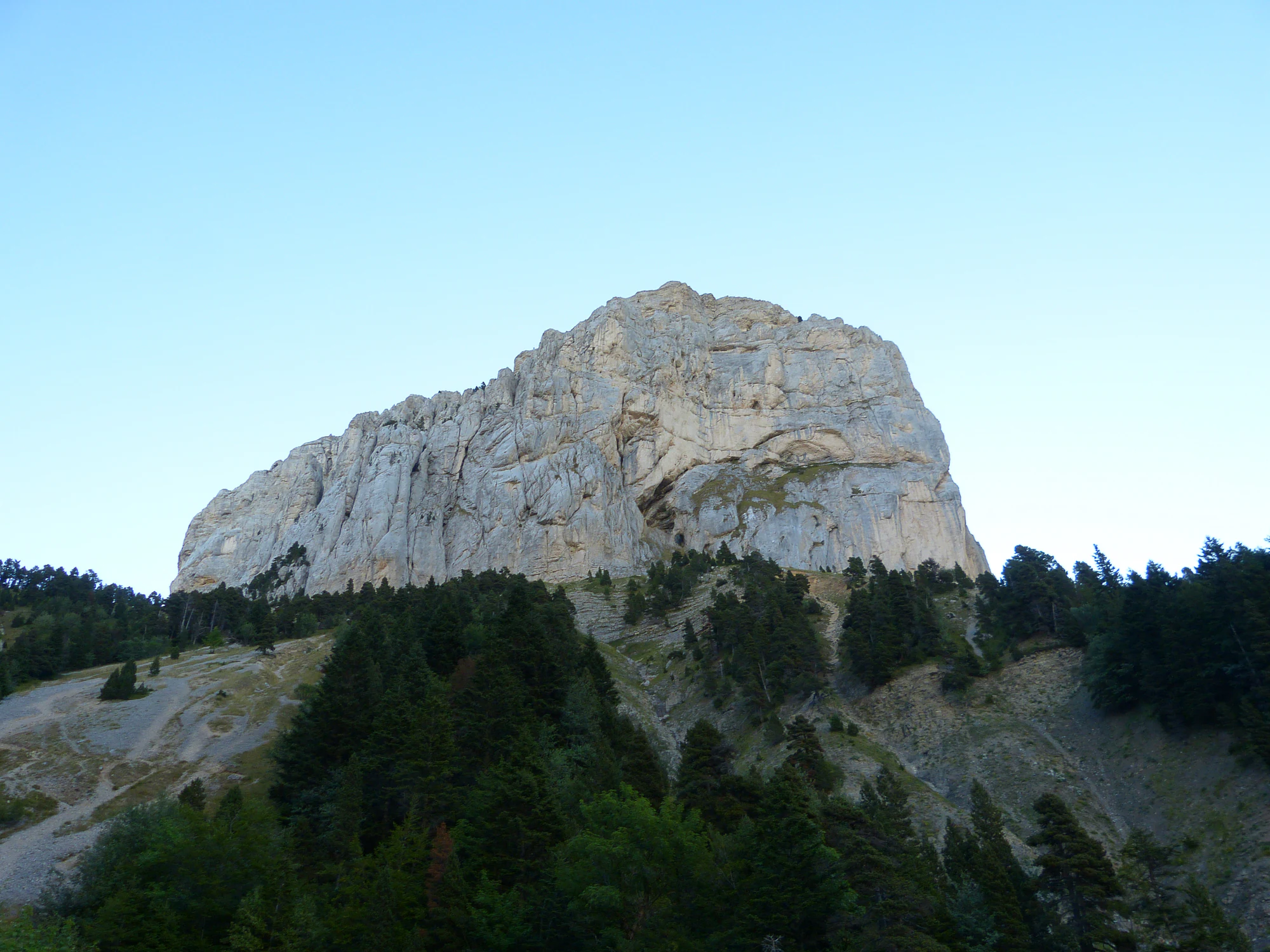
A massive pale limestone wall rises above dark woodland and sloping scree beneath a clear blue sky.

Mont Aiguille above woodland and scree, photographed in September 2012. This is wider Vercors landscape context, separate from the Peuil outing; it is not a summit-walk suggestion.

“Le Mt Aiguille” — Jerome Bon, CC BY 2.0. Source: https://www.flickr.com/photos/girolame/7999042262/. License: https://creativecommons.org/licenses/by/2.0/. Original unchanged. · Creative Commons

Walks and routes

The Peuil interpretive circuit

Start at the Tourbière du Peuil car park in Claix and follow the numbered ENS interpretation trail with its discovery booklet. The published circuit is 3.5 km and takes 1½–2 hours; allow longer for pauses. Use the booklet map and signs at junctions, rather than following a higher trail simply because it also names the Peuil.

The booklet flags a steep beginning. Expect an outdoor trail rather than a level promenade, and assess the ground before committing the whole group. Anyone needing step-free access should confirm a suitable alternative with the site manager before travelling.

The Peuil interpretive circuit

An unhurried half-day at Peuil

Arrive with water and the booklet already saved. Read the entrance board, then take the opening climb at the pace of the least confident walker. Choose a few interpretation stops to explore properly rather than hurrying to finish them all. Pause for a snack where allowed, take your litter away and return with enough daylight for the drive.

If the children have had enough

Treat the first section as a check on energy, footwear and confidence. A child who finds it uncomfortable is unlikely to enjoy being persuaded onward for a promised animal sighting. Turn back along the route you know when it is safe to do so. A short successful outing is a better introduction than completing a circuit at any cost.

Things to try

Make a three-habitat notebook

Divide a page into wetland, meadow and woodland. At a safe stopping place in each setting, sketch one shape, record one sound and note how bright or sheltered it feels. Children can compare their pages at the end; nobody needs to know every species name to notice how different the habitats are.

Try the shorter family game

The department also offers a separate 2 km Baludik game at Peuil, aimed at families with children under 12 and taking around two hours with activities. Check the official listing and prepare the app before leaving. Its earth paths are not pushchair-friendly, and its route should not be confused with the booklet circuit.

Look for a guided nature date

A local naturalist can help turn a fleeting bird call or a small insect into something memorable. Check the departmental Rendez-vous Nature calendar for Peuil and book when required. Guided outings run on published seasonal dates; arrange one in advance rather than expecting a guide at the trailhead.

Keep the nature theme in Grenoble

For persistent rain or an unsuitable mountain forecast, consider the Muséum de Grenoble at 1 rue Dolomieu, outside the regional park. Its permanent and temporary exhibitions are free; it normally opens Tuesday to Friday in morning and afternoon sessions, and on weekend afternoons, with Monday closure. Check the operator’s hours before travelling. The accessibility page lists a lift, adapted toilet and hearing loops; contact the museum for individual access needs or an adapted group visit.

Wildlife and habitats

Look toward woodland edges from the trail

The bullfinch has a rounded body, black cap and short, substantial bill. The male’s rosy underside is striking; females are quieter beige. This Peuil bird is worth watching for along wooded edges. Use binoculars from the trail rather than following it into cover.

Watch without handling

Long hind legs, a pointed snout and a dark patch behind the eye are useful clues to this brown frog, although identification can be subtle. It is recorded at Peuil. Leave frogs, spawn and tadpoles undisturbed, and use a photograph rather than handling an animal to examine it.

Let the pond keep its secrets

Palmate newts are among the small amphibians recorded at Peuil. They can be difficult to see from a public path, so a quiet look into the water may reveal nothing at all. Their hidden lives are part of the reason this habitat matters. Never net or lift one for identification.

Follow a dragonfly with your eyes

Look for a dragonfly with a broad, flattened abdomen and dark patches at the wing bases. Mature males are blue; females are yellow-brown. This species is recorded at Peuil, and a settled insect is easier to examine than one in flight. Wait at a permitted viewing position rather than pursuing it along the bank.

Stories and discoveries

Water in a limestone landscape

Fine sediments sealed the bottom of a basin at Peuil, helping a shallow lake form in otherwise permeable limestone country. Waterlogged plant remains then accumulated as peat. The trail makes this geological exception tangible: compare the damp hollow with the surrounding slopes, without stepping into the wetland.

Conservation includes working land

Pasture is part of the conservation story here. Grazing helps keep open ground from becoming woodland, allowing a different mix of plants to survive. The regional park also supports agriculture and local livelihoods. When you see a fence, gate or flock, you are looking at a working landscape as well as a place to explore.

When to visit

Spring: watch the ground as well as the flowers

Pick a day when the paths have dried sufficiently after snowmelt or rain. Take layers so a warm climb can be followed by a comfortable pause. Keep to the established path around wet places rather than widening it, and let any wildlife observation happen at a distance.

Summer: leave room for the forecast

Start with enough time to finish before any forecast deterioration. Carry water even though the visit centres on a wetland, and plan shade breaks for children. Warm weather can make insect-watching rewarding, but it is not a reason to enter the marsh for a closer look.

Autumn: a woodland visit with a shorter clock

Give the woodland as much attention as the open landscape: changing leaves, textures and seed shapes make good subjects for a notebook or camera. Plan the return before dusk, check hunting and work notices, and let slippery conditions decide whether to shorten the walk.

Winter: make a fresh decision

Do not carry the summer time estimate into snow or ice. Conditions on a mountain plateau can differ greatly from those in Grenoble. If the route or approach is unsuitable for your equipment and experience, choose an indoor visit and return to Peuil in better conditions.

Getting there and practical advice

Prepare for a self-contained walk

There is a designated Peuil car park and interpretation on site. Bring drinking water, food, suitable clothing and a bag for rubbish. Check toilet and drinking-water facilities before travelling if you depend on them; do not plan around a café at the trailhead.

The farm is an optional extra

The Ferme du Peuil is used for visitor interpretation. Check its opening arrangements if you want to go inside, and plan a satisfying outdoor visit that works even when the building is closed. Respect any private or working areas.

Arriving by road

Use the signed approach to the Tourbière du Peuil car park above Claix and check Itinisère for the journey. Claix’s works page, checked on 18 October 2026, still listed resurfacing on route de Comboire with daytime alternating traffic and no stated finish date. Confirm the approach before travelling, especially if a navigation app sends you through those works.

Public transport changes the scale of the day

The park publishes a bus-linked Peuil outing, but it is a 10.8 km walk with 603 m of ascent and a stated duration of 4¾ hours. That is substantially more demanding than arriving at the plateau car park. Use its current route sheet and the transport operator’s journey planner if choosing it; do not budget for a short walk from a bus stop.

Choose for the person, not the distance

A short total distance says little about steepness, balance or fatigue. The initial slope, natural surfaces and possible wet ground matter more here. If anyone needs step-free access, confirm a specific suitable visit with the departmental team before travelling; do not use the interpretation label as an accessibility guarantee.

Sources and useful links

Wildlife you might spot

4

Each card links to a full Explore page with photos, traits, and fun facts.

We are still adding species preview cards for this place.

Snap map for this place

Start with the big picture, then zoom in to explore individual wildlife observations around this place.

Loading map…

Good to know before you go

Save the discovery booklet before leaving; keep the phone available for navigation and emergencies.

Take drinking water, a snack, footwear with grip and an extra layer for stops.

Stay on the marked paths; the wetland surface is not an invitation to explore off-trail.

Leave flowers, fungi, stones and wildlife where you find them.

Give livestock space and close any gate you have permission to pass through.

Read the entrance notices even if you have visited before.

Fires and bivouacs are not allowed at Peuil; plan it as a day visit.

Frequently asked questions

No. It is the practical focus of this guide, in Claix on the Grenoble side of a much larger regional nature park. The park extends into both Isère and Drôme. A visit here gives you one well-chosen sample of that varied territory.
For this outing, use the departmental booklet’s 3.5 km interpretive circuit. The 2 km smartphone game, other advertised walking loops and the 10.8 km Rando Bus outing are different products. Download the description that matches your plan rather than combining their distances or timings.
At Peuil, dogs must be kept on a lead. Rules change across the Vercors: pet dogs are prohibited throughout the year in the Hauts-Plateaux national nature reserve, even on a lead. Check the rules of every additional site you plan to visit.
The Peuil site is listed as free to enter. An independent walk does not depend on booking a guided activity. Organised nature outings have their own dates, registration arrangements and suitability criteria, which you should check separately.
The photograph shows Mont Aiguille elsewhere in the Vercors, not the Peuil route. It is included for wider landscape context. Its summit is not a casual walking destination, and the image provides no information about present access.

Recent snaps at this place

Recent snaps will appear here as new observations are added.

View all ›

Take the discovery with you

Exploring Vercors Regional Nature Park?

Identify the wildlife you spot, learn as you go, and keep a collection of the adventure.

  1. 1Spot it
  2. 2Snap it
  3. 3Keep the discovery
