
Snappit logo
Snappit
Get App
Generic illustration, not a photograph of this venueIllustration
ParkKR

Wolchulsan National Park

Wolchulsan rewards choosing one side of the mountain well.

About

Wolchulsan rewards choosing one side of the mountain well. The Cheonhwang gateway puts the famous bridge and steep eastern rock routes within reach; Gyeongpodae approaches through a wooded valley; Dogapsa gives access to the western ridge and Miwangjae grassland. Muwisa adds early-Joseon temple architecture on the Gangjin side. These are different outings with different starting points, rather than stops on a quick driving loop. The mountain is compact on a map, but repeated climbs, narrow stairs and a substantial descent make a summit day physically serious. Planning to visit? Download the Snappit app to identify the wildlife you spot in real-time.

Wolchulsan became a national park in 1988. Its appeal combines granite landforms, a long association with mountain worship and Buddhist sites at the foot of the slopes. Cheonhwangbong is listed by KNPS at 809 metres above sea level; that summit elevation should not be confused with the ascent of a particular hike.

What to do here

Choose the bridge circuit if the bridge is your main goal, and a summit route only if everyone is comfortable on steep rocky ground. For a quieter cultural day, visit Dogapsa or Muwisa without adding a high ridge. Families who want help understanding the landscape can ask about the park’s nature programme at Cheonhwang.

Seasonal info

Summer shade is most useful on the valley approaches, while exposed rock sections can still be hot and tiring. Autumn adds the possibility of silver-grass scenery around Miwangjae. Winter ice can restrict the Sajabong connection, so a summer route description is not enough for winter planning.

Accessibility

The bridge and summit trails have steep gradients, rock steps and narrow metal stairs; they are unsuitable for wheelchairs or strollers. A foothill visit may be more manageable, but no continuous step-free temple or nature-trail circuit has been verified here. Ask about the exact path, toilets and drop-off point before travelling.

Don't miss

1

The Cloud Bridge and the rock walls around it

2

Cheonhwangbong and the broad agricultural landscape below

3

Miwangjae grassland and the western granite ridge

4

Dogapsa’s Haetalmun Gate and Muwisa’s Geungnakbojeon Hall

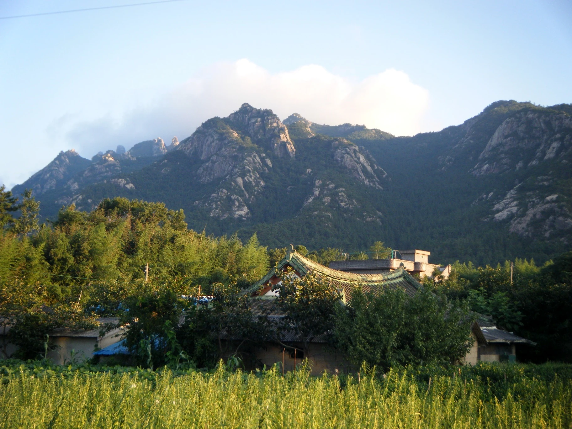
Forested granite ridges rise behind green fields, trees and low village rooftops beneath a pale blue sky.

Wolchulsan’s rocky skyline above farmland and rooftops, photographed on 18 August 2010 according to the uploader. The exact viewpoint is unverified, and this historical image does not show current trail conditions.

“mountain” — Bikepacking Adventure CC0 (cosmicwindblown2), Flickr. CC0 Public Domain Dedication. Unchanged original. · Creative Commons 1 · Creative Commons 2

Walks and routes

Cloud Bridge circuit from Cheonhwang

KNPS publishes 3.3 km and 2 hours 30 minutes for the circuit from the park visitor centre via Cheonhwangsa, the Cloud Bridge and Baram Falls junction back to the visitor centre. Choose it for the bridge itself rather than committing to the summit. The small temple comes early; the sustained climb and the narrow descent make the middle of the outing the demanding part. Open the official bridge description.

Shorter does not mean level: expect steep slopes and metal stairs on both sides of the bridge section. Turn back if heights or footing become uncomfortable.

Cloud Bridge circuit from Cheonhwang

Cheonhwang summit circuit

This is the substantial mountain outing from the Cheonhwang gateway, taking in the Cloud Bridge and Sajabong connection toward Cheonhwangbong, then descending toward Baram Falls. KNPS gives a walking estimate of 4 hours 20 minutes. Set aside a fuller day for rests and slow stair sections, especially on the way down. Confirm the exact current loop on the official course map; its summary and detailed page disagree on total distance.

Steep rock, stairs, narrow passages and sections with fixed ropes demand secure footing and confidence with exposure. This is a poor choice for an inexperienced group in deteriorating weather.

Cheonhwang summit circuit

Gyeongpodae to Cheonhwang via the summit

The published crossing is 6.7 km and 4 hours 40 minutes. Its Gyeongpodae-to-Cheonhwangbong section alone is 3.3 km and about 2 hours, one way. A wooded valley gives a gentler approach, but the descent toward Baram Falls and Cheonhwang is steeper. Arrange pickup at the far end before setting off; this route does not return you to the starting car park. Read the official crossing description.

The shaded approach still includes steeper stretches and steps. The summit and eastern descent make this a mountain hike rather than an accessible valley stroll.

Gyeongpodae to Cheonhwang via the summit

Dogapsa to Gyeongpodae across the western ridge

For Miwangjae’s grassland and the rocks around Gujeongbong, consider the 6.9 km crossing from Dogapsa through Baramjae to Gyeongpodae. The official summary gives 3 hours 40 minutes, while its detailed stages total 3 hours 50 minutes; allow extra time rather than treating either as a deadline. The stated 6.9 km is the Dogapsa–Baramjae–Gyeongpodae itinerary, not an added Cheonhwangbong summit detour. Read the detailed stages.

Expect alternating climbs and descents on the ridge, followed by a valley descent. A gentler finish does not remove the need for hiking footwear and enough energy for the whole crossing.

Dogapsa to Gyeongpodae across the western ridge

Sanseongdae to Gwangamteo junction

KNPS lists 2.6 km and 1 hour 45 minutes from Sanseongdae car park through Sanseongdae to Gwangamteo junction. That is a one-way approach ending at a junction, not a complete summit round trip. It offers an alternative view of the rock landscape and Yeongam plain, but onward walking and the return need their own plan. Read the official Sanseongdae description.

Treat it as a mountain ascent, with the return descent still to come. It is not a short, level lookout walk.

Sanseongdae to Gwangamteo junction

A first visit without a summit commitment

Start at Cheonhwang, ask about the day’s restrictions, and choose the Cloud Bridge circuit only if the group is ready for its stairs. Keep the afternoon flexible for a meal and recovery rather than adding a second gateway. If the climb is unsuitable, use a confirmed interpretation session or a separate temple visit instead.

A western-side day

Give Dogapsa an unhurried look before deciding between a short permitted return walk and the full Dogapsa–Gyeongpodae crossing. Attempt the crossing only with suitable weather, an early enough start and a confirmed ride from the finishing side. Save Muwisa for another visit if transport or daylight is tight.

Things to try

Spend time at Dogapsa

Pause at Haetalmun, the temple gate rebuilt in 1473 and designated a National Treasure. A visit focused on its architecture can stand alone or start a western-side walking day. Keep voices low around worship and follow local photography signs; temple access does not automatically mean the adjoining mountain trail is open.

Choose Muwisa for early-Joseon architecture

Geungnakbojeon Hall dates to 1430. Its restrained gabled exterior and richly decorated interior give you something quite different from the mountain’s dramatic rock shapes. Allow time to appreciate the building from permitted viewing areas, and respect services or conservation restrictions. Visit from the Gangjin side rather than adding an unverified trail connection.

Book a nature interpretation session

The 2026 “Sing of the Moon-Rising Mountain” programme is listed as a 90-minute, all-ages activity meeting at the Cheonhwang nature-trail entrance beside the visitor centre. Its content includes learning about the park’s insect-eating sundew. Check dates, booking requirements and the language offered before making it the centrepiece of a family visit.

When the mountain is wet or closed

Skip exposed ridges and the bridge when conditions are unsuitable. If roads and temple grounds remain safely open, a short visit to Muwisa or Dogapsa can still be worthwhile; neither should be assumed to provide unrestricted indoor shelter. During severe weather, postpone the park visit altogether.

Wildlife and habitats

Round-leaved sundew

This tiny insect-eating plant is a Wolchulsan flagship species. Primary research documented it growing naturally in Dogap wetland and studied cultivation and transplantation for restoration. That history does not promise an accessible wild sighting today. Ask about the interpretation programme instead of entering wetland habitat; any microscope demonstration is an educational encounter, not proof of a wild plant found on your walk.

Stories and discoveries

A mountain with more than one ecological story

Wolchulsan’s dry-looking rock skyline is only part of its habitat picture. The park also has a documented wetland sundew population and a history of restoration research. Looking after those less conspicuous places matters as much as protecting the famous granite scenery.

Gujeongbong’s name

KNPS links Gujeongbong’s name to nine basin-like hollows in the rock. Appreciate the landforms from the permitted trail; do not climb beyond barriers to reach a hollow or reproduce a photograph.

When to visit

Spring

Choose a clear day for the rock scenery, but check seasonal fire-prevention restrictions before selecting a ridge route. Bloom dates are weather-dependent; plan around walking conditions rather than a promised flower display.

Summer

The Gyeongpodae woodland offers shade, yet the summit day still includes exposed sections. Carry enough water, allow a slower pace and abandon the climb when heavy-rain or thunderstorm warnings threaten. A rain-cleared morning does not guarantee a safe afternoon descent.

Autumn

The Miwangjae grassland gives a specific reason to choose the western route. Keep daylight for the descent and road transfer. Anyone considering Sanseongdae in the 2026 autumn window should make the reservation check before arranging transport.

Winter

Ice on rock and metal stairs changes the character of these walks. Verify the Sajabong connection and current entry cutoff, and choose a foothill visit if your equipment or experience does not match the conditions. Do not use a closure barrier as a place to improvise a detour.

Getting there and practical advice

Prepare at the gateway

Use toilets before climbing and carry what you need for the day. The operator’s traverse guidance warns that the mountain route has no shelter or toilets along the way; its Dogapsa exit description places parking and toilets at the gateway. Do not plan on obtaining drinking water high on the mountain. For facilities or route questions, the park office lists 061-473-5210.

Public transport and gateway choice

KNPS describes travel to Cheonhwang via Gwangju’s bus terminal, Yeongam terminal and a local village bus. Check current departures and the last return before travelling; no usable timetable is confirmed here. Show your chosen gateway name when arranging transport: Cheonhwang, Dogapsa, Gyeongpodae and Sanseongdae are not interchangeable destinations. For a crossing, agree the exact pickup point and a realistic collection time.

Ask about a specific lower-level visit

For limited mobility, ask the park or temple about the distance from drop-off to the intended viewing point, steps and accessible toilets. Do not rely on a generic “easy” course label: the bridge description itself warns of continuous steep slopes. A shorter visit at one gateway is easier to adapt than a cross-mountain plan.

Sources and useful links

Wildlife you might spot

1

Each card links to a full Explore page with photos, traits, and fun facts.

We are still adding species preview cards for this place.

Snap map for this place

Start with the big picture, then zoom in to explore individual wildlife observations around this place.

Loading map…

Good to know before you go

Choose your descent before climbing; a crossing can leave your car on another side of the mountain.

Carry drinking water and food from the start. Do not rely on a summit shop or a working spring.

Wear footwear with reliable grip and keep your hands free on the narrow stairs.

Save the official trail map before setting off and follow the signed open route at junctions.

Keep photography stops clear of stairs, bridges and narrow passages.

Leave protected wetlands and restoration areas undisturbed; a flagship species is not an invitation to search off-trail.

Frequently asked questions

Yes. The official Cloud Bridge circuit returns to the Cheonhwang visitor area without including Cheonhwangbong. It is shorter than a summit outing, but the approach and descent are still steep.
Its wooded ascent is gentler than the Cheonhwang side, but the full crossing still climbs to the summit and descends steep rock and stairs. Assess the entire route, especially the descent.
The 2026 autumn notice applies to the uphill Sanseongdae–Gwangamteo Samgeori section. Check the dated notice and the [KNPS reservation system](https://reservation.knps.or.kr/trail/searchTrailReservation.do) for your visit; do not assume the rule applies to every trail or that an unselected booking calendar proves availability.
It is better to choose one temple or save them for another day. Dogapsa and Muwisa are on different approaches, and a tiring descent plus road transfers can consume the time you expected to spend sightseeing.

Recent snaps at this place

Recent snaps will appear here as new observations are added.

View all ›

Take the discovery with you

Exploring Wolchulsan National Park?

Identify the wildlife you spot, learn as you go, and keep a collection of the adventure.

  1. 1Spot it
  2. 2Snap it
  3. 3Keep the discovery
