Snappit logo
Snappit
Get App
Generic illustration, not a photograph of this venueIllustration
ParkNavarra, Spain

Bardenas Reales Natural Park

Bardenas Reales is a landscape of pale slopes, flat-topped hills and deeply cut gullies in southeastern Navarra.

About

Bardenas Reales is a landscape of pale slopes, flat-topped hills and deeply cut gullies in southeastern Navarra. The first surprise is how much detail appears in ground that looks almost bare: layers in a hillside, a cap of harder rock, or small plants holding their place between patches of exposed soil.

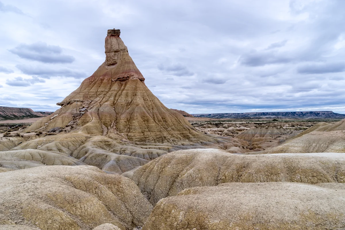
For a first visit, keep the plan small. Begin at the Los Aguilares information centre, then follow staff advice to the Castildetierra and Barranco de las Cortinas walking area. The pointed Castildetierra landform makes a memorable introduction to erosion; the short walk gives you time to look at the surrounding terrain without committing to a long, exposed hike.

The wider park includes the open plateau of El Plano, the strongly eroded Bardena Blanca and the more wooded Bardena Negra. Agriculture and grazing are part of this landscape too. This guide concentrates on one outing in the Blanca, leaving the other sectors for another day. Military land is off limits, and a path appearing on an old walking app does not make it an authorized route. Don't forget to bring the Snappit nature identification app along to scan local species.

Bardenas has long been a shared working landscape. Archaeological finds record early settlement, while later royal grants helped establish the grazing and other use rights held by the congozantes: 19 municipalities, two Pyrenean valleys and a monastery. These rights should not be confused with the territory belonging to each of those municipalities. Bardenas Reales became a natural park in 1999 and a UNESCO Biosphere Reserve in 2000. The purpose of visiting carefully is easy to see here: landforms, steppe habitats and traditional uses occupy the same open space.

What to do here

Ask for the current access map at Los Aguilares, look around the displays, then drive by an authorized route to Castildetierra. If staff confirm that the ground and access are suitable, follow the designated Barranco de las Cortinas walk. Finish with a quiet pause to look across the landscape from a permitted stopping place.

Seasonal info

Spring and autumn can bring torrential rain as well as pleasant walking weather. Postpone the barranco walk during rain or when staff advise that tracks are damaged or muddy. Breeding-season restrictions, hunting days, military activity and events can change which routes are available.

Accessibility

The information centre has facilities for visitors with reduced mobility, including an accessible toilet. Castildetierra has inclusive interpretation and a tactile model. Ask staff about the current approach surface and parking; keep the barranco walk optional if uneven ground is difficult for your group.

Don't miss

1

Castildetierra’s narrow pillar and protective rock cap

2

A short walk through the eroded terrain of Barranco de las Cortinas

3

The information centre’s introduction to the park’s wildlife and human story

4

The contrast between bare-looking ground, dryland plants and wide skies

The tapering Castildetierra rock formation, capped by a dark resistant layer, rises from pale gullied terrain beneath an overcast sky.

Castildetierra rises above the eroded badlands of Bardenas Reales, photographed in August 2015.

Bardenas - Castildetierra.jpg — Jean-Christophe BENOIST / Wikimedia Commons / CC BY 3.0 · Creative Commons

Walks and routes

Castildetierra and Barranco de las Cortinas

Visit Navarra describes a 1.15 km short walk at Castildetierra and Barranco de las Cortinas. Collect the current route advice before setting off and allow 30–60 minutes with stops. Follow the designated walking route rather than drawing a circle around the formation or exploring side gullies. Travel between the centre and the walk separately; the 1.15 km is not the distance from Los Aguilares.

Expect an outdoor path through eroded ground. Ask staff about footing, any steps and changes after rain, especially if you use a wheelchair, walking aid or pushchair. Use the Castildetierra viewing and interpretation stop instead if the walk does not suit your needs.


Castildetierra and Barranco de las Cortinas

A relaxed 2–3 hour visit

Start with 30–45 minutes at Los Aguilares for the displays, toilets and current route advice. Continue by a permitted vehicle route to Castildetierra, stop at the interpretation and, if conditions suit, spend 30–60 minutes on the designated short walk. Keep the remaining time for slow driving, pauses and getting out before the visitor closing limit. If the walk is closed or uncomfortable, let the centre and viewing stop be the whole visit.

Things to try

Read the shape of Castildetierra

Compare the harder cap with the softer material beneath, then look for horizontal bands in the surrounding slopes. Try sketching the outline rather than moving closer to touch or climb it. The landform is a small, clear example of the uneven way rock wears away.

Explore the tactile interpretation

At Castildetierra, inclusive information panels and a tactile sculpture by Mapi Gutierrez help explain the landform. Ask staff where the usable approach is today and which formats are available. The model offers a way to understand the shape without touching the fragile natural formation.

Take a quiet wildlife pause

Bring binoculars if you have them and spend a few minutes looking from an authorized path or stopping place. Keep clear of nests and feeding or resting animals. The Muladar Mainate photographic-hide activity is currently listed as suspended after fire damage, so do not build this visit around a hide session.

Make it a centre visit or postpone

The park advises against entering when persistent rain or damage has affected tracks. If staff confirm the centre approach is suitable and the building is open, focus on its displays. Otherwise, postpone this outdoor visit; a barranco or dirt-track drive is not a wet-weather substitute.

Wildlife and habitats

Griffon vulture

Look across the sky from a permitted stopping place. If a large bird appears, watch its shape and flight with binoculars rather than following it towards a cliff.

Egyptian vulture

At the centre, ask how to distinguish this species from a griffon vulture. Keep any distant wildlife watching on the public routes, and give birds space to carry on undisturbed.

Ocellated lizard

If you notice a lizard from the path, stay still and give it space to retreat. Do not lift stones or leave the route in pursuit of it.

European rabbit

Think about how small mammals fit into this open landscape’s food web. Enjoy any chance encounter from the path without feeding or approaching the animal.

Aleppo pine

The pinewoods of the wider Bardena Negra offer a useful contrast with this visit’s open Blanca scenery. Learn the contrast at the centre rather than adding an unplanned cross-park detour.

These species belong to the wider park’s story, and wildlife may stay out of sight on a short visit. Watch from authorized paths, keep well away from nests, and never use bait, playback or pursuit to obtain a photograph.

Stories and discoveries

Water made much of this dry scenery

The layers began as sediments in the Ebro basin. Later drainage and erosion exposed and cut into them. Rain may be scarce, but intense downpours help explain the gullies you can see today.

Sparse vegetation is still habitat

The low plants and open ground support dryland communities adapted to these conditions. Not every bare-looking patch is damaged woodland waiting to grow back: climate and soil naturally limit what can grow in parts of Bardenas.

When to visit

Spring and autumn

Choose settled weather and keep a rain alternative. Seasonal bird-protection measures can limit access elsewhere in the park. The 2026 reopening of named El Plano–Blanca Alta routes was specifically for pedestrians on authorized paths; it was not permission to explore every trail.

Summer and winter

In hot weather, reduce the walking and avoid the hottest part of the day. In winter, allow for cold wind and a much earlier departure. Centre opening and the park’s one-hour-before-nightfall exit rule are separate limits; plan around whichever affects your visit first.

Getting there and practical advice

Los Aguilares information centre

The centre is on Carretera del Parque Natural, km 6, approached from the NA-8712 at km 0.8. Its published 2026/27 timetable is 09:00–14:00 and 15:00–17:00 from 1 September 2026 to 19 March 2027; from 20 March to 31 August 2027 the afternoon opening is 15:00–18:00. Continuous opening is announced for 25–29 March 2027. Confirm holiday changes on +34 948 830 308 or [email protected].

Displays, map and toilets

The centre offers visitor advice and a free map, with an archaeological display, a diorama and representations of characteristic birds. An accessible toilet is listed. Use the stop to settle practical details before heading out; carry the water and food you will need rather than relying on supplies beside the walk.

Approach from Arguedas

Navigate to the information centre rather than to the middle of Bardenas. The signed access leaves the NA-8712 at km 0.8 and leads to the centre at km 6 of the park road. Ask staff which authorized vehicle route to use for Castildetierra that day; do not let navigation send you across military land or through the closed El Paso link.

If you are travelling without a car

Arrange your transport to and from the centre and Castildetierra before leaving town. Ask the visitor centre about authorized guided options and confirm the meeting point and return. Do not treat a bus to Arguedas or Tudela as transport to the short-walk start.

Plan the centre and viewing stop first

The information centre is listed as adapted for reduced mobility, with an accessible toilet. Castildetierra has inclusive panels and a tactile model, but that does not describe every section of the outdoor approach. Tell staff about your wheelchair, walking aid or pushchair and ask about the current parking-to-viewpoint surface and the opening of the toilet.

Keep the barranco walk optional

Discuss uneven ground, possible mud and the route after recent rain before choosing the walk. For a wheelchair, walking aid or pushchair, ask staff to help choose the most suitable outdoor section. A shorter viewing visit is a worthwhile choice if the walking route is unsuitable.

Sources and useful links

Wildlife you might spot

5

Each card links to a full Explore page with photos, traits, and fun facts.

Snap map for this place

Start with the big picture, then zoom in to explore individual wildlife observations around this place.

Loading map…

Good to know before you go

Check the park’s current notices before leaving, then confirm your route at Los Aguilares: +34 948 830 308 or [email protected].

Bring drinking water, a hat, sun protection and shoes with grip. Carry a layer for wind or cold, and shorten the visit if anyone struggles with the heat.

Keep to permitted paths and roads. Do not climb Castildetierra or other formations, enter military land, or follow informal tracks over slopes and fields.

Use designated parking, keep roads clear and give farm vehicles and livestock space. The vehicle limit is 40 km/h, or less where signed; groups of five or more vehicles are prohibited.

Keep children beside you near gullies and eroded edges. Turn back if the ground becomes slippery or the weather worsens.

Take photographs from allowed public routes. Leave stones, plants and wildlife where they are; recreational drones, fires and camping or overnight stays outdoors are prohibited.

Keep dogs on a lead no longer than 3 m. Pets are not allowed inside park buildings; the rules provide an exception for guide dogs accompanying visually impaired visitors.

Plan your departure for at least one hour before nightfall. The park’s general visiting hours begin at 08:00; the information centre has separate opening hours.

Frequently asked questions

The visitor rules allow independent walking on authorized paths and routes, subject to closures. A guided visit is optional. Arrange organized activities with an authorized provider, and ask the centre about any permissions needed for your plans.
No. The official walking-route list treats Barranco Cortinas Castildetierra and Cortinillas as separate routes. The access path to Cabezo de Cortinillas remains listed as closed because of falling-rock risk. Do not add that climb to this outing.
Do not rely on it as a through-route to the Blanca. On 16 October 2026, the operator still listed the link between El Paso and the Perimetral as closed following storm damage. Use the Arguedas approach for this plan and check the current notices before travelling.
The centre and interpretation at Castildetierra provide useful options. Ask staff about the vehicle approach, parking and the ground between the car and the interpretation point. Choose the viewing visit if the barranco path does not suit your needs.
Ordinary non-professional nature photography is allowed on permitted routes when it does not disturb wildlife. If you are shooting professionally, commercially or for public dissemination, follow the park’s authorization procedure. Recreational drones are prohibited.
General visitor access ends one hour before nightfall, so plan photographs and your exit around that limit. Camping and overnight stays outdoors, including in campervans, are prohibited under the visitor rules.

Recent snaps at this place

Recent snaps will appear here as new observations are added.

View all ›

Take the discovery with you

Exploring Bardenas Reales Natural Park?

Identify the wildlife you spot, learn as you go, and keep a collection of the adventure.

  1. 1Spot it
  2. 2Snap it
  3. 3Keep the discovery