Snappit logo
Snappit
Get App
Generic illustration, not a photograph of this venueIllustration
ParkKR

Mudeungsan National Park

The mountain’s best-known rock formations are Seoseokdae and Ipseokdae, near Jangbuljae, and Gwangseokdae above Gyubongam temple.

About

The mountain’s best-known rock formations are Seoseokdae and Ipseokdae, near Jangbuljae, and Gwangseokdae above Gyubongam temple. Their upright columns contrast with the loose blockfields scattered across the slopes. The national park covers 75.425 km², with Cheonwangbong rising to 1,187 m. That height describes the mountain, not a freely accessible hiking destination. A first visit works well around Jeungsimsa and Jungmeorijae; fit walkers can aim higher when weather, daylight and current controls permit. Don't forget to bring the Snappit nature identification app along to scan local species.

Mudeungsan became a provincial park in 1972 and Korea’s 21st national park on 4 March 2013. Its temple routes and older mountain paths predate that designation. The larger Mudeungsan area gained UNESCO Global Geopark status in 2018; that geological designation covers a different, wider landscape than the national park.

What to do here

Choose one gateway before planning your walk. Jeungsimsa offers temple approaches and a climb to Jungmeorijae, with longer routes towards the columnar rocks. Dowon village in Hwasun starts a substantial circuit to Jangbuljae and Gyubongam. Wonhyo lies on another side of the mountain, where construction currently interrupts familiar routes. Avoid combining separate trailheads into a crossing unless you have confirmed the complete route and your return transport.

Seasonal info

Access checked 18 October 2026: both park offices displayed partial controls. Three routes into Wonhyo plaza remain listed as closed for works. The eastern office posted a reopening notice after a rain warning, but this was not a complete all-clear. Check the [western controls](https://mudeung.knps.or.kr/front/portal/safe/acsCtrDtl.do?menuNo=8000340&parkId=122000) and [eastern controls](https://mudeung.knps.or.kr/front/portal/safe/acsCtrDtl.do?menuNo=8000340&rstId=0026) for your actual route.

Accessibility

The principal mountain walks include steps, uneven stones, gradients and exposed ground. The Dangsan Tree course becomes rougher beyond the tree, despite its relatively approachable reputation. Ask the park about a specific short approach and accessible facilities if you need step-free access; neither a temple approach nor a boardwalk near the rocks establishes an accessible end-to-end route.

Don't miss

1

Jeungsimsa’s woodland approach and the broad saddle at Jungmeorijae

2

Ipseokdae and Seoseokdae’s upright volcanic columns

3

Gyubongam beneath Gwangseokdae’s rock wall

4

Spring flowers, autumn grasses and the changing mountain forest

Walks and routes

Jeungsimsa–Dangsan Tree–Jungmeorijae

Start at the Jeungsimsa-area parking approach and walk past the temple towards the protected old zelkova known as the Dangsan tree. Beyond it, stones, steps and blocky ground lead to Jungmeorijae’s open saddle. KNPS gives 4.0 km and 1 hour 35 minutes one way. Allow roughly 3–4 hours or longer for the out-and-back, including breaks, and extend that allowance for a temple visit. The saddle is a worthwhile destination in its own right; reaching it does not commit you to Jangbuljae.
Jeungsimsa–Dangsan Tree–Jungmeorijae

Saeinbong ridge towards the upper columns

This longer western approach links Unsobong, Saeinbong and Seoinbong before Jungmeorijae, then climbs towards Jangbuljae, Ipseokdae and Seoseokdae. Expect repeated ascent and descent, rocky ridge sections and a substantial climb beyond Jungmeorijae. The final published Jangbuljae–Seoseokdae section is 0.9 km, about 30 minutes, via Ipseokdae. Make this a full-day hiking choice and confirm your descent separately. The official page’s overall distance and segment figures disagree, so use its map with current park advice rather than treating a quoted total as precise.

Saeinbong ridge towards the upper columns

Dowon–Jangbuljae–Gyubongam circuit

From Dowon village in Hwasun, climb through forest to Jangbuljae, then continue towards Gyubongam beneath Gwangseokdae and return to Dowon. The official sections total 7.5 km and 4 hours 30 minutes: 3.3 km/2 hours to Jangbuljae, then 4.2 km/2 hours 30 minutes through Gyubong. Allow 5–6 hours or more with stops. The latter section includes uneven blockfield terrain near Jigong Neodeol and is graded more demanding. This is a complete mountain circuit, not a brief temple walk; it does not include a Seoseokdae extension.

Dowon–Jangbuljae–Gyubongam circuit

Wonhyo old-trail circuit: interrupted by works

The familiar Neutjae–Old Trail course links Wonhyosa, Neutjae, the former Donghwasa site, Jangbuljae and the old-trail descent. Do not follow the advertised circuit as a currently continuous route: the ironmaking-site–Wonhyo plaza section is closed, along with Eoksaepyeongjeon–Wonhyo plaza and Pungamjeong–Wonhyo plaza. Ask the western park office for an approved alternative or choose a different entrance.

Wonhyo old-trail circuit: interrupted by works

A flexible first visit

Start at Jeungsimsa, spend time on the temple approach, then decide at the Dangsan tree whether the group is comfortable continuing to Jungmeorijae. Return by the same open route. A clear turnaround keeps this a satisfying half-day even if the high rocks are hidden by cloud.

A geology-focused hiking day

Choose either the Jeungsimsa-side upper-rock route or the Dowon–Gyubong circuit. The first favours Ipseokdae and Seoseokdae; the second makes Gwangseokdae and its temple setting central. Start early, carry lunch and water, and keep the choice to one coherent route with a confirmed return.

Things to try

Read the rock landscape

At Ipseokdae and Seoseokdae, look for the repeated upright joints; at Gwangseokdae, notice how the columns frame Gyubongam. These are volcanic-rock formations, with UNESCO identifying prominent tuff columns from Cretaceous volcanism. Avoid the common shortcut of calling every polygonal column basalt. The loose angular blocks elsewhere on the slopes tell a different story of weathering and cold-climate processes.

Make room for the temples

Jeungsimsa fits naturally into the western approach, while Gyubongam is part of the longer Hwasun circuit. Keep voices low around worship areas and follow posted photography instructions. Give the architecture and forest some unhurried time rather than making the temple an extra summit checkpoint.

Keep a genuine fallback

If high winds, thunderstorms, heavy rain or closures rule out the mountain, postpone the hike. In mild cloud without a warning, a short open lower approach may still be worthwhile after checking locally. Do not use a steep forest path or rocky temple circuit as a supposed bad-weather shortcut.

Wildlife and habitats

Eurasian otter

KNPS identifies the Eurasian otter, Lutra lutra, as one of Mudeungsan’s flagship species. Its presence says more about the importance of freshwater habitat than about your likelihood of seeing one during a hike. Watch quietly from established paths; never enter water or investigate bank-side shelters to find it.

Tiger lily

The park highlights tiger lily, Lilium lancifolium, among its summer flowers. Treat flowering as a seasonal possibility, not a guaranteed stop: timing varies with elevation and weather. Photograph plants from the path and leave flowers, stems and bulbs untouched.

The park’s distinctive spring shrub

Lindera sericea is the other flagship species described by KNPS. It is a deciduous shrub with yellow flowers around April. Its conservation value makes careful observation more useful than collecting or searching off-trail for a specimen. The park description supports its presence, but does not promise a publicly marked viewing location.

Stories and discoveries

A summit height is not a walking target

Cheonwangbong’s 1,187 m elevation is the mountain’s height above sea level, not the ascent gained on any route in this guide. Inwangbong access and special military-zone summit events have different rules. Choose a named, currently permitted destination rather than simply asking for “the summit.”

When to visit

Spring and summer

Spring brings azaleas and the flagship shrub’s flowers. Summer offers leafy forest and lilies, but heat, heavy rain and storm warnings can change access quickly. An early forest outing in settled weather is more practical than pushing towards exposed rocks in a deteriorating forecast.

Autumn and winter

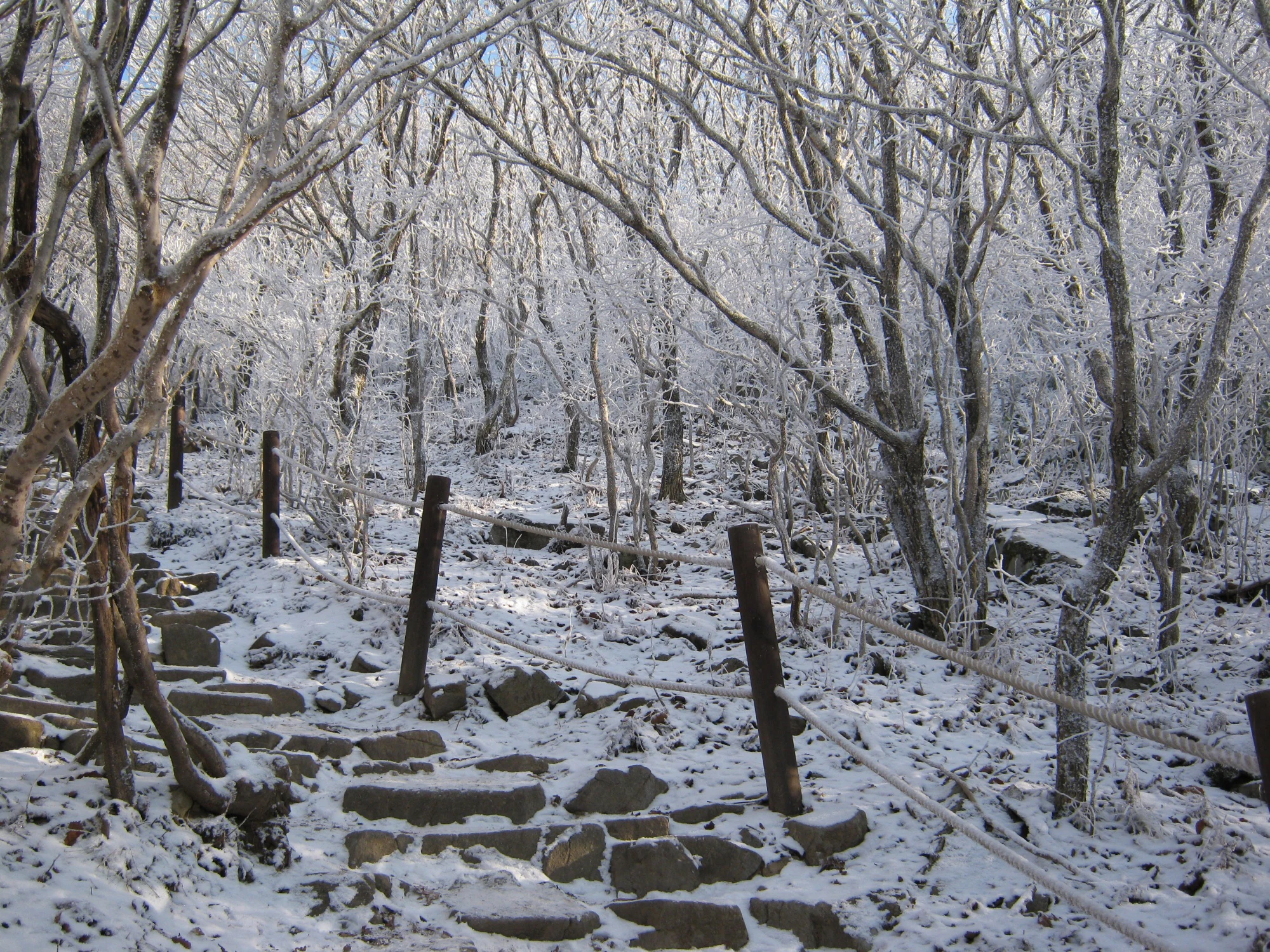
Autumn foliage and silvergrass suit the open saddles and upper slopes. Winter can coat steps and branches in snow and rime, while shaded stones remain icy. A winter attempt needs appropriate traction, warm layers and a conservative turnaround; if conditions exceed your equipment or experience, choose another day.

A narrow flight of stone steps winds through bare woodland coated in snow and frost, with a rope handrail beside the path.

Winter steps on Mudeungsan, photographed on 16 December 2010, before national park designation in 2013. The exact trail is unidentified. This historical scene does not show present trail access or conditions.

Photo: “steps” by Bikepacking Adventure CC0 (cosmicwindblown2), Flickr. CC0 1.0; original file unchanged. · Creative Commons 1 · Creative Commons 2

Getting there and practical advice

Use the right park office

For the Jeungsimsa/Wonhyo side, call the western office on 062-227-1187. For Hwasun and eastern approaches, call 061-371-1187. Ask about the exact trail segments, entry cutoffs and any mobility requirements. A route’s presence on the course selector does not mean it is open today.

Plan self-sufficiently above the trailhead

Carry food, water, warm layers and a charged phone. The simple wind shelter at Jangbuljae is a brief resting place, not a promise of overnight accommodation or staffed services. Confirm toilets, drinking water and parking arrangements at your chosen entrance before committing to a long route.

Navigate to an entrance, not the mountain name

For the western walks, use the Jeungsimsa bus terminus or park approach as your destination; the temple itself is farther along the walk. For the Dowon circuit, use Dowon visitor support centre in Iseo-myeon, Hwasun. Wonhyo is a separate northern approach affected by works. Check the official course page’s transport tab, then verify current bus departures and the last return connection locally; no live timetable or parking price is established here.

Choose a manageable endpoint

A shorter out-and-back near the Jeungsimsa approach can be more flexible than committing to a ridge, but inspect the actual slope and surface before continuing. For wheelchair users or anyone needing reliable step-free access, ask the park about the exact route, toilets and drop-off rather than relying on the course difficulty label. Upper viewing decks are reached by mountain paths.

Sources and useful links

Wildlife you might spot

2

Each card links to a full Explore page with photos, traits, and fun facts.

Snap map for this place

Start with the big picture, then zoom in to explore individual wildlife observations around this place.

Loading map…

Good to know before you go

Carry water from the start. The Saeinbong route description notes no spring before Jungmeorijae; do not build your day around finding drinking water.

Set a turnaround time before climbing. A published uphill time excludes the descent, rests, photographs and transport connections.

Use footwear with reliable grip. Loose stones, wet rock and shaded winter steps make the return more demanding than a city walk.

Stay on the designated paths and viewing structures. Do not climb the columns, cross barriers or step into vegetation for a photograph.

Download the official route information before leaving the trailhead, and confirm closures with the relevant park office.

Frequently asked questions

Do not assume so. Cheonwangbong is the highest peak, while the designated public approach towards Inwangbong is a separate destination. The Seoseokdae–Inwangbong section reopened on 4 October 2025, but current controls and entry limits still need checking. The military-zone summit opening is a separate event; the published programme requires Korean nationality and identification. No current event date is established here.
It is a mountain walk. The official Dangsan Tree course is 4.0 km and 1 hour 35 minutes one way, with rocky ground and steps after the tree. Turning back near the temple or tree can make a shorter visit, but assess the surface and remaining distance for your group.
The specific 1.2 km section from Suman visitor support centre to the Jangbuljae junction reopened at 04:00 on 12 September 2026. The notice was published the day before. That section length is not the complete distance to Jangbuljae or the upper viewpoints; recheck the rest of your intended route.
No. This guide covers the national park as one place, including its different administrative sectors and entrances. The wider geopark includes additional sites; a geopark attraction is not automatically inside the national park.

Recent snaps at this place

Recent snaps will appear here as new observations are added.

View all ›

Take the discovery with you

Exploring Mudeungsan National Park?

Identify the wildlife you spot, learn as you go, and keep a collection of the adventure.

  1. 1Spot it
  2. 2Snap it
  3. 3Keep the discovery