
Snappit logo
Snappit
Get App
Generic illustration, not a photograph of this venueIllustration
ParkHauts-de-France, FR

Parc naturel régional des Caps et Marais d’Opale

The name gives you the two ends of the story: caps are headlands; marais are marshes.

About

The name gives you the two ends of the story: caps are headlands; marais are marshes. Between the coast and the Audomarois lie hedged pastures, wooded country and chalk slopes. Those changes in water, soil and exposure make this a rewarding park to explore in separate, unhurried visits. A reedbed and a chalk cliff may both hold nesting birds, but they offer entirely different food and shelter.

This is an inhabited landscape in Hauts-de-France, spanning Pas-de-Calais and part of Nord. Villages, farms and working waterways are integral to it. The Grand Site des Deux-Caps is its coastal showcase; the Marais audomarois is the wider wetland landscape; the Réserve naturelle nationale des Étangs du Romelaëre is one protected part of that marsh. Each has its own access arrangements.

For a first visit, begin at La Grange Nature in Clairmarais and follow the public Sentier du Blongios. The raised path brings you close to wetland vegetation without needing a boat. If your party wants a much shorter outing and the wind is gentle, choose the Dover Patrol loop instead. There is no need to fit both into one day. Eager to name that creature? Identify any animal you find during your visit using the Snappit app.

Romelaëre’s pools are a human-made inheritance: peat extraction, especially during the nineteenth century, left water-filled workings that became valuable habitat. Across the wider Audomarois, market gardening, livestock and boats have shaped the marsh over centuries. Its UNESCO biosphere recognition in 2013 reflects this relationship between people and nature. On the coast, the Dover Patrol memorial recalls the protection of shipping during the First World War. These landscapes reward looking for both wildlife and the work that shaped its surroundings.

What to do here

Follow one of the two named routes below. At Romelaëre, spend time watching the relationship between open water and reed cover. At Blanc-Nez, look across the strait from the designated viewpoints, then turn inland to notice the grassland behind the cliffs. Binoculars make either visit more rewarding.

Seasonal info

The Romelaëre public season is 15 March–15 December; La Grange Nature has a shorter season. In winter, choose an open coastal visit only when conditions are suitable. A closed marsh gate is a reason to change plans, even if birds are visible beyond it.

Accessibility

Both selected route cards list wheelchair and pushchair access. Romelaëre uses wooden decking; the coastal loop has slopes and wind exposure. Ask about the current usable route, gradients, parking and toilets before travelling if any of these determine whether your visit is possible.

Don't miss

1

Romelaëre’s raised path through a landscape shaped by peat cutting

2

The contrast between marsh birds and the seabirds of Blanc-Nez

3

A short coastal loop with a memorial and views towards England

4

La Grange Nature’s family exhibition and wildlife-friendly garden

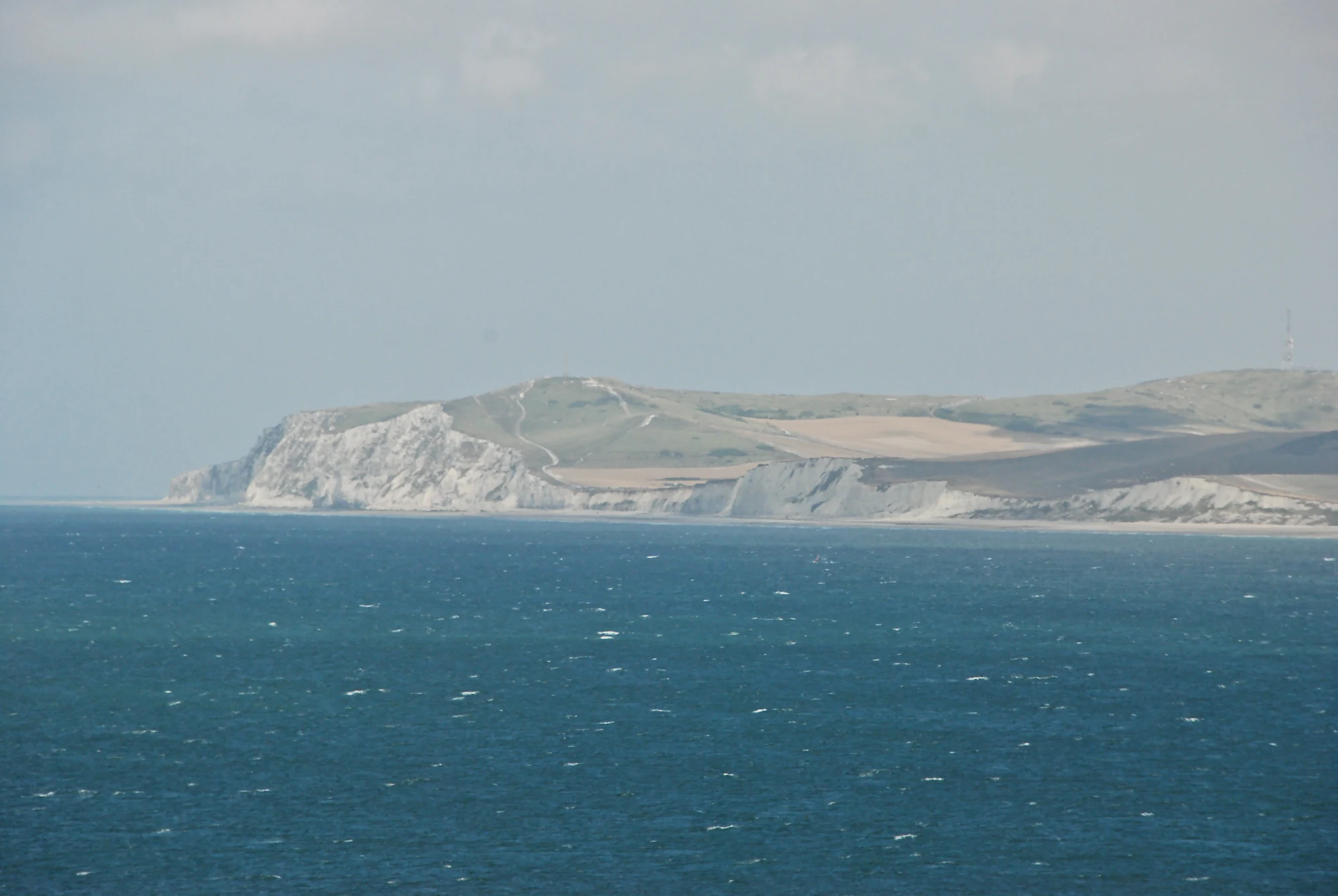
Pale chalk cliffs and fields across blue sea beneath a hazy grey sky, with a small mast on the distant ridge.

Cap Blanc-Nez across the sea, photographed in August 2010. This distant coastal view shows another part of the regional park, away from the Romelaëre marshes.

“Le cap Blanc Nez (France)” — Stephane Mignon, CC BY 2.0. Source: https://www.flickr.com/photos/topsteph53/5008287063/. License: https://creativecommons.org/licenses/by/2.0/. Original unchanged. · Creative Commons

Walks and routes

Sentier du Blongios: the marsh outing

Start at the La Grange Nature car park, 18 rue du Romelaëre, Clairmarais. The departmental route card gives a 4.3 km out-and-back with 9 m of ascent, including the approach from this starting point; it describes 2.8 km through the reserve. Follow the signed public route to the bird observatory and retrace the permitted route to the same car park. Allow 1½–2½ hours with stops, rather than treating the card’s one-hour walking estimate as a wildlife-visit target. Pause where the path widens, watch open water first, then scan the reed edge. You can turn back earlier if the full outing is too much for your group.

The route card identifies wooden decking and wheelchair/pushchair access. Confirm the condition of the complete approach and boardwalk with La Grange Nature; wet wood can be slippery. Do not assume a separate return path or another nearby circuit has the same accessibility.


Sentier du Blongios: the marsh outing

Boucle de la Dover Patrol: the coastal alternative

Use Parking du Blanc-Nez on the Sentier du Blanc-Nez at Escalles. The departmental route is a 1 km loop with 18 m of ascent and a published walking time of 30 minutes; allow up to an hour for the views. Follow the managed loop around the memorial and viewpoints, returning to the same starting point. In clear weather, the English coast appears across the strait. Look inland too: the Fond Pignon viewpoint shows an artificial pool associated with construction of the Channel Tunnel. Keep this a cliff-top outing, without adding a descent to the beach.

The route card lists wheelchair and pushchair access. The published ascent is a reminder that accessible does not mean perfectly level. Strong wind can make an otherwise short walk unsuitable; confirm current conditions and any assistance needed.

Boucle de la Dover Patrol: the coastal alternative

An easy half-day around the marsh

Arrive during La Grange Nature’s opening hours if you would like advice before setting out. Choose the full Blongios out-and-back or an earlier turnaround according to your group. Leave time afterwards for the exhibition or garden, subject to opening and admission arrangements. This gives a more rounded introduction than hurrying on to the coast.

Two visits, two very different habitats

Give the marsh one half-day and the coast another, preferably choosing the clearer, calmer weather window for Blanc-Nez. Between them, notice the hedged farmland rather than treating it as empty space. The journey helps make sense of the regional park as a connected, lived-in landscape.

Things to try

A marsh food-finding challenge

From a safe stopping place, compare a bird standing at the water’s edge with one swimming or diving. Ask children how each reaches its food. If no birds appear, sketch the three layers you can still see: water, emergent stems and sky. The landscape itself tells you why a wetland supports different ways of living.

Photograph two kinds of edge

At Romelaëre, frame the meeting of reed cover and open water. At Blanc-Nez, photograph the meeting of pale land and sea from the designated path. On a two-visit trip, compare the pictures: one habitat breaks into small sheltered spaces, while the other is open to wind and waves. A phone is enough; staying on the path matters more than a closer angle.

When conditions change the plan

For ordinary rain during its season, La Grange Nature’s indoor exhibition is a useful alternative. Strong wind, thunderstorms or flooding call for postponing the outdoor visit, rather than switching automatically from cliffs to trees or marsh. Check Météo-France for both departments and Vigicrues for the Aa basin. Neither suggested route requires a tidal crossing; if adding a beach visit, check local tide times and coastal warnings separately.

Wildlife and habitats

Great cormorant

Romelaëre’s open water and nearby perches are places to watch for this dark diving bird. Its long neck and hooked bill help distinguish it from a duck. If one is fishing, wait where you are and see where it resurfaces; another may be perched with wings spread.

Grey heron

Recorded at Romelaëre, this large grey bird is a good reason to scan water margins carefully. Look for the outline of a long neck and legs among the stems. Let the bird continue its own business instead of walking towards it for a photograph.

Common reed

Common reed is recorded in the reserve. Its tall stems make the reedbed a habitat with an interior that is largely hidden from the path. Notice where dense vegetation meets open water: that boundary is often more informative than a view straight into an unbroken wall of stems.

Yellow water-lily

This aquatic plant is listed for Romelaëre. During the growing season, look from the public path for floating leaves and yellow flowers where water is visible. Compare its low, spreading surface with the vertical reeds; do not lean over the decking or reach for a flower.

Black-legged kittiwake

Cap Blanc-Nez supports nesting kittiwakes, a very different setting from Romelaëre’s reedbed. Watch seabird movement from the managed upper viewpoints. The colony belongs to the cliff habitat, so do not expect close views from every section of the loop or approach the edge to improve them.

Stories and discoveries

The path’s small namesake

Blongios is the French name used for the little bittern, a discreet marsh heron recorded at Romelaëre. The route name celebrates a real wetland inhabitant, but it is not a promise of a sighting. A visit can be satisfying without finding its most elusive bird.

A plant with a complicated success story

In 2026, Eden 62 reported an encouraging new stand of water soldier, Stratiotes aloides, at Romelaëre. This aquatic plant has long been naturalised in the Audomarois. Its progress is one useful clue about the water, but the manager cautions that other ecological indicators are less positive. One flourishing species cannot tell the whole marsh’s story.

Grazing helps keep the coast open

The short vegetation behind Blanc-Nez is part of the wildlife habitat. Eden 62 uses sheep grazing to help maintain the chalk grassland. If a flock is present, watch it from the path and close any permitted gate behind you; the animals are doing a conservation job.

When to visit

Spring

After the marsh reopens on 15 March, the reedbed’s sounds are part of the attraction. From April, combine the walk with La Grange Nature. Keep observation calm during breeding: nests may be hidden even when you cannot see a bird.

Summer

Look for floating leaves and compare them with the upright plants along the water’s edge. Bring water and sun protection for exposed stretches. On the coast, nesting-colony protection measures run through 31 August; a quiet view from the managed path is the right way to enjoy the birds.

Autumn and winter

Autumn offers a different marsh palette and shorter visiting days. La Grange Nature’s regular season ends on 31 October, while the reserve’s published season continues to 15 December. Beyond that, use an explicitly advertised guided event or choose another open destination. Do not enter the reserve simply because an old itinerary suggests a winter walk.

Getting there and practical advice

La Grange Nature

The published season runs from 1 April to 31 October: weekdays 10:00–12:00 and 14:00–17:30, Saturdays and Sundays 14:00–18:00. Check holiday arrangements before travelling. This Eden 62 centre offers an interactive family exhibition, an educational garden and a shop. Ask about current exhibition charges, activities and toilet access when planning: 03 21 38 52 95.

Reserve admission and daily access

The Saint-Omer tourist office lists Romelaëre as free to visit during its published season. Guided activities can have separate booking requirements or charges. Check the entrance notice for the day’s conditions and leave ample daylight for the return; do not assume visitor-centre hours are the reserve’s gate hours.

Getting to the marsh

For Romelaëre, use the route card’s La Grange Nature car park as your destination. Saint-Omer is the rail gateway to plan around; arrange the onward and return journey to Clairmarais before setting off. Mouvéo changed its network in 2026, so consult its current planner rather than relying on an old bus number or assuming an on-demand service will suit a visitor.

Getting to the coast

The Grand Site lists regional bus 427 serving coastal villages including Escalles and Sangatte, with rail connections through Calais or Boulogne. Check the stop-to-start walk and return service for your date. Drivers should check the Grand Site’s traffic notice too: temporary D940 closures between Tardinghen and Wissant are scheduled on selected hunting days in November 2026–February 2027.

Choose the route, then check the details

For a wheelchair or pushchair outing, ask specifically about the complete Blongios approach and decking, or the Dover Patrol loop. Useful questions are whether every section is open, where the accessible parking is, whether slopes require assistance, and which toilets are usable. The two route listings are helpful starting points, but they do not describe every chair, access need or day’s surface conditions.

Sources and useful links

Wildlife you might spot

5

Each card links to a full Explore page with photos, traits, and fun facts.

Snap map for this place

Start with the big picture, then zoom in to explore individual wildlife observations around this place.

Loading map…

Good to know before you go

Pack binoculars and a windproof layer, even if your starting point feels sheltered.

Use the whole-route distance when planning from a car park, not just the length of a section inside the reserve.

Keep children beside you on decking and cliff paths; watching birds can easily distract from the edge.

Leave plants, feathers and shells where they are. Photographs and sketches make better records here.

Plan food and toilet stops before the walk rather than assuming there will be facilities along it.

At an observation point, let birds settle before moving again. Avoid calls, playback and feeding.

Frequently asked questions

No. It is a national nature reserve within the larger Audomarois marsh landscape, which is itself part of the regional park. The coast is another area of the same park, with separate starting points and rules.
Pet dogs are prohibited at Romelaëre, including on a lead. Ask Eden 62 about guide-dog arrangements if needed. On the Cap Blanc-Nez nature-site paths, dogs must be on a lead; separate beach rules apply.
No. The Blongios route is a land-based visit. A guided boat trip on the wider marsh is a different activity with its own booking and access rules; the reserve path does not grant access to private banks or closed waterways.
That is not part of either suggested walk. Cliff fall and rising tides make the shore a different undertaking. For this visit, stay on the managed upper path and enjoy the sea from the viewpoints.

Recent snaps at this place

Recent snaps will appear here as new observations are added.

View all ›

Take the discovery with you

Exploring Parc naturel régional des Caps et Marais d’Opale?

Identify the wildlife you spot, learn as you go, and keep a collection of the adventure.

  1. 1Spot it
  2. 2Snap it
  3. 3Keep the discovery




