
Snappit logo
Snappit
Get App
Generic illustration, not a photograph of this venueIllustration
ParkNortheast Spain, Spain

Posets-Maladeta Natural Park

Posets-Maladeta is big-mountain country, but your first visit need not begin with a summit.

About

Posets-Maladeta is big-mountain country, but your first visit need not begin with a summit. The interpretation centre in Benasque is a useful place to get your bearings: use its mountain model and displays to connect the names on a map with the forests, high pastures and ice-shaped scenery outside. Then ask which paths suit the weather and the least experienced walker in your group.

For an unhurried introduction, combine the centre with the signed Gorgas de Alba botanical circuit when it is clear of snow and ice. It is a short woodland outing with a rocky section and waterfall viewpoints, so there is plenty to notice without a long march. Allow time for pauses rather than treating the official walking time as a deadline.

Beyond this Benasque gateway, the park spreads across the Benasque, Chistau and Barrabés valleys. Aneto, at 3,404 metres, belongs to its much more demanding alpine world. Glacial basins, lakes called ibones and the disappearing water at Aigualluts tell the story of ice and rock on a grander scale. These places invite a return visit with a route chosen deliberately; reaching a scenic valley does not make the next summit a casual extension. Wondering what that bird or insect is? Find out on your visit using the Snappit nature app.

Posets-Maladeta was declared a park in 1994 and reclassified as a natural park in 1998. Long before those protections, local communities shaped its grazing grounds, hay meadows, stone farm buildings and paths. The old route followed in part by Gorgas de Alba linked Aragón with southern France through the Benasque valley; today, a short woodland walk can offer a glimpse of that older mountain geography.

What to do here

Visit the Benasque interpretation centre, then choose one outdoor outing. Gorgas de Alba gives you woodland and waterfalls; experienced walkers with a suitable forecast can plan a longer Aigualluts day. Look at the landscape as well as the destination: compare a wooded slope, an open pasture and the bare rock above.

Seasonal info

Shuttle seasons and road restrictions change. The published autumn 2026 Besurta service ran on selected days only, with its notice ending on 11 October. Confirm the arrangement for your date. Snow, storms and frozen paths can change an apparently modest walk into a mountain undertaking.

Accessibility

Benasque’s interpretation centre has listed accessible facilities, including reserved parking, an adapted information point, Braille text and an adapted toilet. Gorgas de Alba has rocky and uneven sections and is not a step-free alternative. Ask staff about your specific mobility, sensory or pushchair needs before choosing an outdoor route.

Don't miss

1

The mountain model and nature displays in Benasque

2

The woodland and waterfall viewpoints on Gorgas de Alba

3

Aigualluts’ remarkable disappearing water, on a separately planned walking day

4

The contrast between forest, pasture and the Aneto–Maladeta skyline

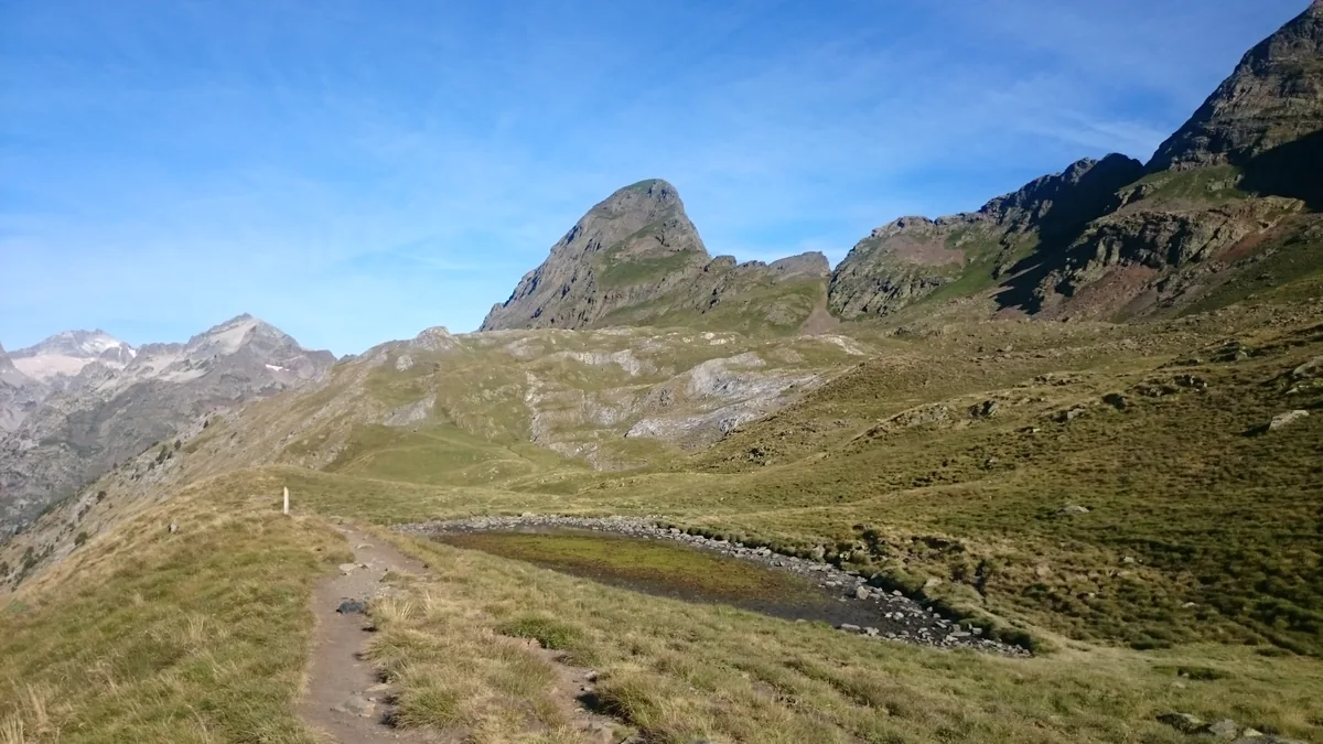
An angular mountain peak rises above open grassy and rocky slopes, with a small shallow pool and a narrow footpath in the foreground.

Pico Salvaguardia and the high-mountain landscape of Posets-Maladeta near Portillón, photographed in August 2016. This is broader park context beyond the Benasque gateway visit.

JP - Valle Posets-Maladeta 02.jpg — Javier Pina / Wikimedia Commons / CC BY-SA 4.0 · Creative Commons

Walks and routes

First outdoor choice: S1 Gorgas de Alba

From the Plan de Turpi area, follow the signed botanical circuit through woodland to the waterfall viewpoints and back. The operator and municipal route pages give 2.2 km; the park’s walking time is 55 minutes. Allow 1½–2 hours for a slower visit with stops. Ask the centre for the correct starting place and current route sheet before driving up the valley.

A short walk still needs steady footing: the municipal description includes a rocky climb and walkways by the gorge, and rates it medium. Expect uneven ground. This is not a step-free route; wet rock, leaves or ice can be slippery.


First outdoor choice: S1 Gorgas de Alba

A longer day: full S2 to Forau de Aigualluts

The full municipal route starts at Pleta de la Sarra, passes La Besurta and reaches the Forau before returning the same way: 13.4 km with 340 m of ascent. Its published walking time is four hours; allow 5–6 hours with pauses, plus access time. Use it for a group comfortable with that distance. The sinkhole and water-worn landscape are the purpose of the outing, without adding a summit.

This is a mountain footpath with uneven ground, climbs and exposed weather. It is not wheelchair or standard-pushchair access. Keep back from the Forau rim and use the designated path and safe crossing points.

A longer day: full S2 to Forau de Aigualluts

Another valley: S9 Valle de Salenques

For a separate visit from the Montanuy/Barrabés side, the official Salenques circuit follows a river through beech woodland. It is listed as 3.9 km and 1 hour 30 minutes walking; allow about two hours with pauses. Treat it as its own valley outing rather than a quick addition after Benasque.

The operator classifies this route for mountaineers. Its short length does not establish easy or step-free access. Ask for the current surface and crossing conditions and match the route to the group.

Another valley: S9 Valle de Salenques

A flexible first half-day

Check the centre’s opening date and weather first. Spend around an hour with the displays and ask about S1. If the group and conditions are a good match, travel to its confirmed start and allow 1½–2 hours for the loop, then return to Benasque for a meal. If the path is unsuitable, the centre can still be the main visit.

A walking day with one clear objective

For the full S2, obtain the route information in advance and start with enough daylight for the return. Pack lunch and allow time beyond the published walking duration. Set a turnaround time that suits the slowest walker; leave the Renclusa circuit, lake extensions and summits for separately researched outings.

A visit with limited mobility

Begin with Benasque’s interpretation centre and confirm parking, entrance and toilet arrangements by phone. If planning a later Chistau visit, ask about the accessible Cruz de Puyadase viewpoint and San Juan de Plan centre. They are separate locations, not an accessible walking link from Benasque.

Things to try

Give the mountains a shape

At the centre, choose one summit on the model and follow the valleys around it. Ask each person to pick a feature to look for later: a forest edge, a boulder, a river bend or an open slope. It turns the outing into a small investigation instead of a race to the next sign.

Make a woodland comparison

On Gorgas de Alba, pause where the trees change. Compare leaf shapes, needles and the light reaching the ground. Use photographs or a pocket guide for identification; leave leaves, bark and berries where they are.

Listen before looking

Stop in a safe place and spend a quiet minute noticing water, wind and bird sounds. Binoculars help with distant animals, but you can enjoy a nature walk without finding a particular species.

Make it a centre day

When cloud hides the summits or the ground is unsafe, the displays can be the visit rather than a consolation stop. Use the model to plan a return, watch the audiovisual and ask staff what weather would make your preferred route suitable. Confirm the centre is open before setting out.

Postpone the gorge walk when needed

A wooded route is not automatically a safe rain alternative. Wet rock and rising water deserve respect, and thunder or strong wind is a reason to change the day. Return for the waterfalls in better conditions rather than trying to get closer for a photograph.

Wildlife and habitats

Beech woodland

On a woodland walk, compare the broad leaves and the light beneath the canopy with the darker evergreen trees nearby. The Gorgas de Alba and Salenques descriptions both include beech, making trees a satisfying focus close to the path.

Yew among the conifers

The botanical route includes yew. Use the route information to help separate it from the other evergreen trees, and photograph rather than collect or taste any plant material.

Alpine marmot

In suitable open mountain habitat, pause and scan from the marked path rather than following an animal. Marmots belong to the park’s higher grassland story; do not expect them beside the town centre or make finding one the test of a successful visit.

Griffon vulture

Leave time to look up from a safe stopping place. A distant soaring bird is worth watching even before you can identify it; binoculars and a field guide are more useful than trying to get nearer.

Golden eagle

The park’s rocky landscape supports golden eagles. Treat a possible distant sighting as something to check carefully, and avoid approaching cliffs, perches or nests. Learning the landscape can be as rewarding as confirming the bird.

Wildlife sightings depend on season, weather and chance. Watch quietly from a distance, never feed animals or play calls, and keep to the path so that a search for a photograph does not disturb wildlife or fragile ground.

Stories and discoveries

Water with an unexpected destination

At Forau de Aigualluts, water disappears underground and re-emerges on the Val d’Aran side, feeding the Garonne system. That surprising journey is one reason to look closely at the limestone landscape instead of treating the Forau simply as a photo stop.

A lake has a local name

An ibón is a mountain lake, often held in a basin shaped by former glaciers. The word appears on many park maps. Seeing the name is an invitation to check a route’s distance and ascent, not evidence that the lake is close to the road.

The open ground has a human story too

Hay meadows, stone bordas and summer grazing grounds sit alongside the mountain scenery. Give working animals and farm access space; the landscape is also part of local livelihoods.

When to visit

Spring and early summer

Look for the return of leaves and strong water flow from safe paths. Check snow and river conditions before planning higher walks; an open road or sunny town does not settle those questions. Keep a lower, shorter alternative ready.

Summer

Start walking early enough to avoid rushing the return, and check the storm forecast. Carry sun protection and warm layers together. Read the exact seasonal access notice for your trailhead and leave a margin for bus queues.

Autumn

Woodland can be a rewarding focus, but wet leaves, early frost and shorter daylight call for careful timing. Shuttle services may already have ended or be running only on selected days. Recheck rather than relying on a summer plan.

Winter

Choose the interpretation centre on an advertised opening date or arrange an appropriate specialist-led activity. Do not follow a summer walking description onto snow or ice without winter skills and equipment. Check the mountain forecast and avalanche information where relevant.

Getting there and practical advice

Benasque visitor information

Centro de Interpretación de Benasque: Avenida de Francia, s/n, 22440 Benasque. Telephone +34 974 55 20 66. Displays, a mountain model and an audiovisual introduce the park, and staff provide route information. Get your questions answered here before heading into a valley.

Opening sessions

The timetable linked from the centre page gives 10:00–14:00 and 16:00–19:00 from 23 September to 19 March; from 20 March to 22 September the afternoon session ends at 20:00. These hours apply only on the calendar’s opening dates. Check both before travelling, especially outside summer.

Food, water and toilets

Use town facilities before travelling to a trailhead and carry enough drinking water and food for the outing. Do not count on a mountain stream being safe to drink or a seasonal refreshment stop being open. Ask staff where the nearest suitable toilets are for your selected route.

Other gateways

The park also has interpretation centres at San Juan de Plan and Aneto village. Eriste’s centre focuses on the Pyrenean glacier natural monuments. Check each centre’s own opening calendar rather than applying Benasque’s hours to all of them.

Plan around Benasque

For this first visit, use the centre in Benasque town as your meeting and information point. Travel from there to the chosen trailhead only after checking the route and the access road. A town-centre arrival does not put you at the start of a high-valley walk.

Seasonal access has exact dates

The published 2026 summer service covered 20 June–13 September. A separate Besurta notice extended bus-only access on Fridays to Sundays between 13 September and 11 October. Those dates have passed: for a later visit, check the current notice rather than assuming either a shuttle or unrestricted driving. Vallibierna and Espigantosa have their own access arrangements.

Before boarding

Check the operator’s current fare, departure point, last return and payment arrangements. Its published summer information says cash is accepted on the bus and cards at the Vado sales point, with places subject to capacity rather than advance reservation. Tell the operator ahead of time if you need wheelchair access, are travelling in a group or plan to bring a pet; confirm the vehicle and carriage arrangements.

If the road or bus plan changes

Do not park beyond a barrier or drive onto a restricted track. If the intended trailhead is unavailable, choose another confirmed visit instead of adding an unplanned road walk to the mountain route. An earlier road restriction ending is not a statement about today’s snow, damage or traffic controls.

Start with the centres

The park’s accessibility catalogue lists reserved parking, an adapted information counter, Braille exhibition text and an adapted toilet at the Benasque and San Juan de Plan centres. Confirm your specific access needs and that the facilities are available on the day.

A viewpoint in Chistau

The same catalogue identifies Cruz de Puyadase with one reserved parking space, a kerb-free approach, an accessible surface and an accessible interpretation table. Ask the park about the approach road and present condition. It is an option when visiting Chistau, not a nearby replacement trail in the Benasque valley.

Footpaths are a separate decision

The adapted buildings do not make the mountain trails accessible. S1’s rocky section and gorge walkways, S2’s length and mountain ground, and S9’s mountaineer classification each need their own assessment. Share your practical limits with staff rather than relying on a general “family” label.

Sources and useful links

Wildlife you might spot

5

Each card links to a full Explore page with photos, traits, and fun facts.

Snap map for this place

Start with the big picture, then zoom in to explore individual wildlife observations around this place.

Loading map…

Good to know before you go

Check the park’s notices and AEMET mountain forecast before leaving. Ask specifically about remaining snow, icy sections and river crossings on your chosen route.

Wear shoes with grip and carry water, food, warm and waterproof layers, sun protection, a map, a charged phone and a small emergency kit. Bring a headtorch for longer walks.

Choose a turn-back time and leave your route and expected return with someone. Keep the group together and change plans if the weather, pace or conditions are worse than expected.

Check the centre’s calendar as well as its hours. It is not open every day, and its posted timetable includes a 14:00–16:00 break.

Confirm the relevant shuttle and final return before setting off. Besurta, Vallibierna and Espigantosa are different access routes, with separate arrangements.

Stay on marked paths, keep back from waterfall edges and sinkholes, and avoid crossing fast water. Keep children close at rocky steps, viewpoints and stream banks.

Leave plants and rocks in place, take rubbish away and do not light fires. Keep dogs under close control on a lead, give livestock space and check transport rules before bringing a pet.

Treat Aneto and glacier terrain as a separate mountaineering trip requiring appropriate skills, equipment and current advice. In an emergency call 112.

Frequently asked questions

No. The interpretation centre and a suitable woodland walk make a worthwhile first visit. Aneto is a mountaineering objective, with glacier and high-altitude hazards that belong to a different plan.
It can suit children used to walking on uneven ground in good conditions. The route has a rocky section and waterfall viewpoints, and the municipal tourism office rates it medium difficulty. Choose the centre alone if the ground, weather or children’s stamina make the walk unsuitable.
Do not plan on completing Gorgas de Alba with a standard pushchair or wheelchair. Begin with the accessible facilities at the Benasque centre and ask staff for an outdoor option suited to your equipment and the day’s conditions.
It depends on where you start. The full Pleta de la Sarra–Aigualluts return is published by Benasque tourism as 13.4 km. Starting at La Besurta makes a shorter outing, but first confirm access, the exact turnaround point and the correct route sheet. A listing of 6.7 km must not be used as the full return distance from Pleta de la Sarra.
Access is regulated seasonally and can change with weather or other restrictions. Check the park notice and Avanza information for your date. An old timetable or an ended restriction does not tell you whether a road is passable now.
The park’s 2025 management report describes its interpretation centres as free to enter. Check current arrangements with Benasque, especially for groups or organised activities. Seasonal buses have separate fares and boarding rules; check these with the operator.
Choose one valley for the day. Chistau and Barrabés have their own approaches, and combining them with a Benasque walk would take time away from the landscape. The centres at San Juan de Plan and Aneto village can help you plan later visits to those sectors.

Recent snaps at this place

Recent snaps will appear here as new observations are added.

View all ›

Take the discovery with you

Exploring Posets-Maladeta Natural Park?

Identify the wildlife you spot, learn as you go, and keep a collection of the adventure.

  1. 1Spot it
  2. 2Snap it
  3. 3Keep the discovery








