Snappit logo
Snappit
Get App
Generic illustration, not a photograph of this venueIllustration
ParkCastilla-La Mancha, Spain

Ruidera Lakes Natural Park

Ruidera makes most sense when you slow down beside the water.

About

Ruidera makes most sense when you slow down beside the water. The lakes step down a valley, separated by natural barriers built from calcium carbonate. When levels allow, water spills between them; at other times, the exposed rock and quiet pools tell a different part of the story. These are groundwater-fed lakes, so a wet weekend does not guarantee flowing waterfalls.

For a first family visit, keep Ruidera village and El Hundimiento as your anchor. Get current advice at the information centre when it is open, then follow the signs from the village to the waterfall viewpoint. The approach is short enough to leave time for looking, listening and asking how the water got here. The lake margins are habitats to observe, not places to make your own path.

Beyond this easy introduction, the park stretches into both Ciudad Real and Albacete. The visitor centre near Laguna Colgada, in Ossa de Montiel municipality, offers a fuller nature introduction and organized walks. Choose it as a separate stop or the main event of another day. Trying to combine the whole lake chain, a cave tour, swimming and a long walk usually means spending more time moving between places than enjoying them.

The most rewarding contrast is between wetland and dry hillside: tall plants at the water’s edge, submerged vegetation below the surface, and evergreen woodland above. Bring binoculars, let children watch one patch of water for a few minutes, and make room for discoveries that do not need a species name. The natural rock barriers are the park’s defining feature; admiring them without stepping onto them is part of the visit. Unlock an interactive field guide for this spot: get the Snappit app to identify nature on the go.

The lakes have drawn people to this dry landscape for a very long time, and the water has powered mills and other industries as well as supporting wildlife. El Hundimiento is associated with a destructive flood recorded in 1545, a useful reminder that this attractive landscape is also shaped by powerful water. The park was declared in 1979. Cervantes placed a famous episode of Don Quixote in the nearby Cueva de Montesinos, which is now an optional guided visit. More recently, the former Ruidera information centre was refurbished in 2026 to interpret the cultural heritage of the La Mancha Húmeda Biosphere Reserve, adding a wider human story to the lakes.

What to do here

Start with Ruidera and the signed El Hundimiento approach, keeping behind the viewpoint boundary. Add a relaxed look at Laguna del Rey from an open public viewing place. If your group wants a longer outing, reserve the Ossa de Montiel centre-and-Hazadillas walk or select a short section of the official panoramic pedestrian path after checking access.

Seasonal info

Water levels and waterfall flow vary with groundwater conditions and rainfall over time. Summer brings heat and heavier visitor pressure; spring and early summer also call for extra care around nesting wildlife. Outside the bathing season, plan the lakes as a walking and watching destination and check centre opening rather than assuming summer services continue.

Accessibility

The Ossa de Montiel visitor centre is officially listed for visitors with reduced mobility. Its ordinary guided walks include natural ground and, on the longer option, a steep climb. Ask staff to plan a suitable parking or drop-off, toilet and viewing route. Check the Ruidera centre and Hundimiento approach separately, especially following the 2026 centre refurbishment; a short or easy-rated path is not automatically step-free.

Don't miss

1

The short signed approach to El Hundimiento from Ruidera

2

Travertine barriers that show how water can build rock

3

A choice of short lake views or a booked nature walk

4

Wetland plants and waterbirds beside Mediterranean woodland

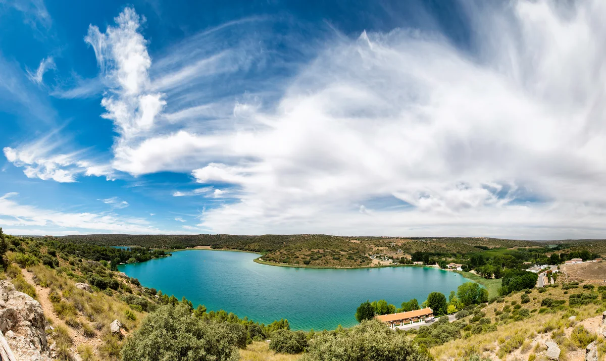
An elevated panoramic view of Laguna del Rey, surrounded by low scrub-covered hills and lakeside buildings under sweeping clouds.

Laguna del Rey in the Lagunas de Ruidera Natural Park, photographed in July 2014.

Panoramica lagunas ruidera.jpg — Marcos Molina / Wikimedia Commons / CC BY-SA 4.0 · Creative Commons

Walks and routes

El Hundimiento: the short first-visit walk

Follow the signed approach from Ruidera to the wooden viewpoint over El Hundimiento, then return the same way. Regional tourism puts the approach at about ten minutes; allow 30–45 minutes for a relaxed visit, excluding extra walking from your parking place. Listen before trying to photograph the water, and notice the drop in level beyond Laguna del Rey. Water flow varies, so the viewpoint is about the landscape as well as the cascade.

Ask about steps, surface condition and the approach from your chosen arrival point before bringing a wheelchair or pushchair. The tourism page calls the walk easy but does not provide a complete step-free access specification. Keep children close and do not lean on the boundary railings.


El Hundimiento: the short first-visit walk

Ossa de Montiel centre and Tinada de las Hazadillas

For a longer family outing, book the official Del Centro al Sendero programme. It combines the Ossa de Montiel centre, an introductory film and a guided walk, returning to the centre. The advertised Hazadillas option totals 4.5 km and about 2½ hours; a longer version linking the viewpoints totals 6 km and about four hours. The 2026 programme advertises selected Sunday departures at 10:15 through 6 December, with exceptions for public holidays and other programmed activities. Confirm your actual date and chosen version.

Although the programme is described as easy, the longer option explicitly includes a steep climb. Tell the organizer about children’s walking stamina or mobility needs before booking. The accessible centre listing does not extend automatically to the trail.

Ossa de Montiel centre and Tinada de las Hazadillas

A short section of the Carretera Panorámica path

The official linear panoramic route is 10.9 km long, but you can ask the centre to select a short open out-and-back beside the central lakes. Allow 45–75 minutes including a viewpoint stop, and turn back while everyone still has plenty of energy. The pedestrian path runs along most, rather than all, of the road corridor. Motor vehicles still use a central two-way lane, with cycle lanes at the margins. This is a shared transport corridor as well as a scenic walk.

The route has accessibility improvements, but a continuous step-free journey is not established for every section. Confirm your exact start, pedestrian continuity, crossings, gradients and parking-to-path connection. Choose a section that works for your chair or pushchair rather than relying on the general low-difficulty rating.

A short section of the Carretera Panorámica path

Ermita de San Pedro to the Cueva de Montesinos entrance

This official path starts at Ermita de San Pedro and climbs the Cuesta de la Almagra to the cave, with interpretive stops along the way. The published distance is 0.8 km one-way, so returning by the same path makes about 1.6 km. Allow 60–90 minutes for the outdoor walk with pauses, and extra time for any separately booked cave visit. It is a good option for older children interested in Don Quixote who are comfortable walking uphill.

The official map rates the route medium difficulty. It is uphill, natural-surface walking and is listed without summer shade. Do not treat the short distance as evidence of wheelchair, pushchair or easy cave access; ask the provider about the underground section separately.

Ermita de San Pedro to the Cueva de Montesinos entrance

A gentle first visit: 2–3 hours in Ruidera

Arrive during a confirmed centre opening and allow 20–40 minutes to orient yourself and ask about the day’s access. Walk to El Hundimiento and back with time to stop at the viewpoint. Finish with a quiet public view of Laguna del Rey and a break in the village. If the centre is closed, keep the outdoor visit short and follow the current signs. This plan does not depend on swimming, a flowing waterfall or driving the entire lake chain.

A guided nature morning: allow most of half a day

Reserve the Ossa de Montiel centre-and-Hazadillas programme and confirm whether you are doing the 4.5 km or 6 km version. Allow time to park and walk the approximately 600 m to the meeting point, arriving before 10:15 when that is your confirmed start. Carry water and a snack. After 2½–4 hours, have lunch or rest rather than adding another ambitious walk. Travel from your accommodation is extra.

A flexible visit with mobility needs

Contact the Ossa de Montiel centre before travelling and ask for one suitable arrival-and-viewing plan, including parking or drop-off and a toilet. Make the centre and a confirmed accessible viewpoint the main experience. If you want to include Ruidera or Hundimiento, check that access separately. Leave enough time to turn around or change plans without pressure.

Things to try

Trace the water without stepping into it

At a permitted viewpoint, ask children which stretch of water is higher and where the overflow would go. Compare a still surface with a visible channel or drop. If there is no flowing cascade, look for the shapes left by water instead. Keep the whole exercise on the path.

Compare three layers of habitat

From an open path, look across water, shoreline vegetation and dry hillside. Notice how the plants change in height and density. You can sketch three simple bands or name their colours without picking anything or moving closer to the shore.

Give a waterbird a minute

Choose one bird through binoculars and quietly follow what it does. Is it resting, swimming or disappearing below the surface? Let children describe the action before searching for a name. Use the centre’s displays or an identification guide to check your guess later.

Add a cultural stop rather than another long walk

Use the refurbished Ruidera centre to connect the lakes with the wider La Mancha Húmeda landscape, or book Montesinos if the Don Quixote story appeals. Choose one addition that suits your group. A cave visit is a separate activity with its own access conditions.

Make water sports a planned activity

If kayaking appeals, ask for an authorized provider and describe the ages and experience in your group. Confirm equipment, safety supervision, permitted waters and cancellation arrangements. The natural barriers and connecting channels are not obstacles to jump or paddle over.

A centre visit, if safe to reach

On a poor-weather day, call before travelling and use an open centre for interpretation and planning. Do not rely on a viewpoint shelter, a narrow lakeside path or an independent cave visit as a storm refuge. If access is affected, leave the outdoor walk for a better day.

Wildlife and habitats

Great crested grebe

Spend a quiet minute scanning open water from a public viewpoint. Watch whether a bird stays on the surface or dives, then use binoculars and an identification guide to decide whether it is a grebe. Do not move towards the shore to follow it.

Western marsh harrier

Include the air above the wetland in your scan. If a raptor appears, watch its direction and behaviour from where you are rather than trying to follow it through the reeds. The park supports nesting birds, so keep well away from any suspected nest.

Eurasian otter

Treat the otter as part of the lakes' hidden life rather than the goal of a family walk. If one appears, remain still and give it room. Keep dogs close and leave waterside cover undisturbed; do not search the banks for dens.

Eurasian golden oriole

At a quiet wooded stretch, pause and listen before looking into the canopy. The centre can help you learn which birds use the waterside trees. Keep your listening stop on the path and let bird song add to the visit even when the singer stays hidden.

Common reed

Look at the bands of tall vegetation bordering the water, without stepping into them. Compare the shape of a reed stand with the nearby sedges and trees, using the centre's interpretation to help with names. These sheltered margins matter to wildlife.

Great fen-sedge

The park's masiega stands are an important wetland habitat. Ask staff to help distinguish them from reeds at a permitted viewing place. Observe their texture from the path and leave the leaves and wet ground untouched.

Holm oak

Look from the path towards the evergreen trees on the drier slopes. Compare that woodland with the tall wetland plants below. The contrast is a good way to see how strongly access to water shapes the landscape, without collecting leaves.

These are wild animals and seasonal plant communities, so what you see will vary. Watch quietly from permitted paths and viewpoints, use binoculars, never feed wildlife and give nests and resting birds plenty of space. Do not enter reeds, lift rocks or approach an animal for a closer photograph.

Stories and discoveries

Water can build a barrier

Rainwater takes dissolved carbonate from limestone underground. When spring water emerges and conditions change, some calcium carbonate is deposited again. Over time, these deposits create the tufa or travertine barriers between the lakes. Mosses and other organisms are part of this living system.

The lakes have a memory of earlier rain

Groundwater is a major part of the lakes’ supply. Water must move through the limestone system before it reaches the surface, so lake levels and cascades do not simply mirror this morning’s weather. That is why a quiet or low-water visit can still reveal something important about the park.

A dramatic viewpoint with a flood story

The El Hundimiento landscape is linked to the great flood of 1545. Looking from the permitted viewpoint, think about how a rare powerful event can reshape the same valley that now seems calm.

A short walk can cross a strong ecological contrast

Wetland plants and submerged vegetation live very close to dry Mediterranean woodland. Those neighbouring habitats help explain the range of wildlife in the park and make careful looking worthwhile even on a modest walk.

When to visit

Spring

Choose a mild day and give birds and shoreline vegetation plenty of space. Water and flowers may add interest, but waterfall flow still depends on the groundwater system. Keep off closed or fragile areas and let the signed viewpoints do the work.

Summer

Keep walking to cooler hours and avoid the unshaded panoramic and Montesinos routes in strong heat. Plan bathing as a separate, supervised family activity in an open designated area. Check current water-quality notices, lifeguard provision and restrictions; an older favourable sample does not establish today’s conditions. Expect busy parking and allow yourself a shorter alternative.

Autumn and winter

Bring warm layers for a slow viewing stop and check daylight and the forecast. Centre calendars are date-specific, and summer support services should not be assumed. After rain, ask about slippery or damaged paths; during strong weather or fire warnings, postpone the outdoor plan.

Getting there and practical advice

Ruidera information and cultural-heritage centre

The park listing places the centre on Avenida de Castilla-La Mancha/N-430, beside the junction with the lakes road, and gives +34 682 219 958. A regional report dated 7 September 2026 describes its refurbishment as the Centro de Interpretación del Patrimonio Cultural de la Reserva de la Biosfera de La Mancha Húmeda. Confirm the current exhibition, entrance arrangements and opening before going. Its attached 2026 calendar uses different colour-coded daily schedules; it is not a promise of year-round daily opening.

Ossa de Montiel visitor centre by Laguna Colgada

Use Carretera La Colgada 21 as the destination. The centre is a lakeside park facility in Ossa de Montiel municipality, not an instruction to drive to the town centre. It provides the starting point for the interpretation programme and is listed as accessible for people with reduced mobility. Phone +34 648 224 233 and check the current date on its opening calendar.

Parking and the last few hundred metres

Use designated car parks and follow local directions when they are busy. For the Ossa guided activity, the organizer recommends the Santos Morcillo car park, approximately 600 m from the centre on foot, and says there is no ordinary parking at the centre. If you need a close drop-off or a reserved accessible space, arrange the exact option with staff.

Toilets, food and drinking water

Ruidera village is the practical place to plan a food or comfort stop for the short visit. The older Ruidera centre listing includes toilets, and the September 2026 park update reports new accessible toilets and parking improvements. Check which specific facilities are open and usable for your needs; do not assume every viewpoint has a toilet or drinking-water supply. Carry your own water.

Booking the 2026 centre-and-trail programme

Use the official activity page to request a place and wait for confirmation. The programme is advertised as free, with a minimum of six and maximum of 25 participants. Replies are handled on working weekdays; check spam and contact [email protected] if you have not heard back within 72 hours, not counting weekends or public holidays. Dates, exceptions and route choice need reconfirming.

Choose a destination before you drive

For the first visit, navigate to Ruidera village and its N-430 information-centre area, then use designated parking. For the guided outing, use the Ossa de Montiel lakeside centre address and its parking instructions. A generic park pin can send you far from your intended walk. The park is spread across a chain of lakes, so allow time between separate stops.

Take care along the panoramic road

The scenic road is still open to vehicles, with a central two-way traffic lane, cycle lanes and a pedestrian path along most of the corridor. Drive slowly according to signs, give pedestrians and cyclists room, and park before looking at a map or taking photographs. A short family walk should use a confirmed continuous pedestrian section.

If travelling without a car

Ask the Ruidera or Ossa de Montiel tourism or park contact about the current bus service, stop and safe final approach, and confirm the return before travelling. This guide does not rely on a shuttle between the lakes. An arrival in a nearby town still needs a separate plan for reaching the actual centre or walk.

Ossa de Montiel: verify the complete visit

The official centre entry identifies access for visitors with reduced mobility. Ask about parking or drop-off, the route to the entrance, toilet access and a suitable viewing point. If a specialist outdoor chair would help, the park advertises a Joëlette loan programme; discuss advance arrangements and assistance with staff rather than assuming it will be available on arrival.

Ruidera and Hundimiento: check after the refurbishment

The Ruidera centre was refurbished in 2026, while its current directory entry still marks accessibility as no. That mismatch is a reason to call, not a reliable account of the new entrance. For Hundimiento, ask specifically about steps, surface firmness and the route from parking. The broad description of an easy ten-minute approach is not an access audit.

Trails and pushchairs

The panoramic path needs a section-by-section check because pedestrian provision covers most of the road rather than all of it. The Montesinos approach climbs uphill; the longer guided Hazadillas option warns of a steep ascent. With a pushchair, choose a confirmed suitable short route and have a comfortable turnaround point.

Sources and useful links

Wildlife you might spot

7

Each card links to a full Explore page with photos, traits, and fun facts.

Snap map for this place

Start with the big picture, then zoom in to explore individual wildlife observations around this place.

Loading map…

Good to know before you go

Keep children close beside the water and at viewpoints. Do not climb or lean on railings: the park describes them as boundary features, not protective safety barriers.

Never walk on, scramble over or cross between lakes on the fragile travertine barriers. Use the official paths, even when a rock ledge looks like a shortcut.

For swimming, use only the currently designated and open bathing area. Check posted water-quality notices and conditions that day; clear water is not proof of safety. Keep children within immediate reach, avoid jumping or diving and stay away from channels, drops and moving water.

Bring drinking water, closed walking shoes, sun protection and a snack. The panoramic path and the Montesinos approach are listed without summer shade, so shorten or postpone them in strong heat.

Check the centre calendar and route advice before travelling: Ruidera +34 682 219 958; Ossa de Montiel +34 648 224 233. The park email is [email protected]. Ask about current works, closures and the exact facilities you need.

Park only in designated places. The panoramic road still carries motor vehicles and cycles, so use the pedestrian space, watch crossings and keep children beside you. Do not stop on the carriageway for photographs.

Keep dogs under close control and use a lead on nature walks, especially in the Hazadillas and Era Vieja wildlife refuge. Keep them out of bathing areas, collect their waste and leave plants and wildlife undisturbed.

Take rubbish away, keep voices low and leave the barbecue at home. Fires and wild camping are prohibited. For a cave tour or water activity, book through an authorized provider and check the current conditions before paying or bringing equipment.

Frequently asked questions

They may be, but do not plan around a guaranteed cascade. The lakes depend strongly on groundwater, and water levels can respond slowly to rain. El Hundimiento is still a place to understand the landscape when flow is low. Ask the park about current conditions before a special trip for waterfall photographs.
No. Bathing is limited to designated areas and can change with water conditions and local restrictions. Use the current signs and advice for the specific place you want to enter, and check whether lifeguards are actually on duty. Channels between lakes, waterfall drops and travertine barriers are not swimming or play areas.
Regional tourism describes the signed approach from Ruidera as about ten minutes. Allow 30–45 minutes for walking out, looking from the viewpoint and returning, with extra time from your actual parking place. Keep to the open approach and check conditions after rain.
The Ruidera centre suits the short village-and-Hundimiento visit. Its 2026 refurbishment added a cultural-heritage focus, so check the current exhibition and opening. The Ossa de Montiel centre is near Laguna Colgada, at Carretera La Colgada 21, rather than in the town centre; it is the meeting point for the nature interpretation programme.
Plan one confirmed suitable outing with staff. Ossa de Montiel has an accessible-centre listing, but you still need to check the approach from parking and toilets. Neither the guided Hazadillas walk nor the uphill Montesinos path should be assumed suitable for an ordinary wheelchair or pushchair. Ask separately about the current Hundimiento approach and accessible viewpoints.
The Hundimiento viewpoint is advertised as free access, subject to any current closure. Reserve the organized centre-and-trail programme and wait for confirmation. An underground Montesinos visit needs an appointment with an authorized provider. Ask the park about requirements for organized groups and specialist activities.
No continuous family loop around all the lakes is proposed here. The park has distinct signed routes, roads, restricted areas and natural barriers. Some official routes are one-way, so the return can double the walking. Pick a named route or a short permitted out-and-back and plan the return before starting.
Do not assume that owning a craft allows you to launch anywhere. Navigation has separate park and river-authority requirements, including measures to prevent invasive species. Ask the park and the Confederación Hidrográfica del Guadiana about your craft and intended lake, or use an authorized operator who can explain the current conditions.

Recent snaps at this place

Recent snaps will appear here as new observations are added.

View all ›

Take the discovery with you

Exploring Ruidera Lakes Natural Park?

Identify the wildlife you spot, learn as you go, and keep a collection of the adventure.

  1. 1Spot it
  2. 2Snap it
  3. 3Keep the discovery