
Snappit logo
Snappit
Get App
Generic illustration, not a photograph of this venueIllustration
ParkAragón, Spain

Sierra y Cañones de Guara Natural Park

Guara is a landscape to look into: pale cliffs, narrow river corridors and rock shaped by water.

About

Guara is a landscape to look into: pale cliffs, narrow river corridors and rock shaped by water. Between the Ebro lowlands and the Pyrenees, its sunnier southern slopes and cooler northern woods give this large natural park strikingly different faces. Birds of prey are part of the attraction, but so are the plants, farming terraces and stonework that reward a slower visit.

For a first taste, make Bierge your base for a short visit rather than trying to cross the whole park. The interpretation centre explains the geology and wildlife, and its outdoor botanical circuit brings the landscape down to a scale children can explore. The immediate recreation area makes it easy to pause without committing to a long walk.

If everyone wants more, choose one separate walking outing after checking conditions with staff. The adapted beginning of the Fuente de la Tamara trail is a short option; the complete trail and the Morrano circuit need more time and walking stamina. Canyoning and climbing belong to a different kind of day, with technical preparation and activity-specific rules. Enhance your adventure: download the Snappit app to identify the local species you encounter.

Guara’s protected status was established by Aragón’s Law 14/1990 of 27 December; its natural-park category followed in 1998. The human story is older and visible in shepherds’ buildings, field terraces and dry-stone structures. Bierge’s displays connect that rural life with the landscape and introduce the area’s prehistoric rock art through a cave reproduction.

What to do here

Begin with the Bierge displays and audiovisual, then explore the botanical circuit outside. Give children a simple challenge: find contrasting leaf shapes and compare the rocks at the interpretation stops. Add a signed viewpoint or one of the walks below only if the weather, access and group’s energy suit it.

Seasonal info

Choose the day’s plan around heat, rain and daylight rather than the calendar alone. High ground can have winter conditions while lower villages feel mild. After rain or when storms threaten, avoid river corridors and ask about path conditions.

Accessibility

Bierge is the most useful starting point for access planning. The official catalogue lists ramped exhibition levels, adapted toilets, Braille and a hearing loop, plus an accessible botanical circuit outside. Confirm the equipment and surfaces you need before travelling. The full hiking trails are separate from these adapted facilities.

Don't miss

1

Learn how water makes canyons, caves and other limestone landforms at Bierge.

2

Explore the centre’s small botanical circuit without taking on a mountain route.

3

Compare woodland, farmland and rock scenery on the Morrano walking circuit.

4

Look for birds of prey from suitable public paths and viewpoints, binoculars in hand.

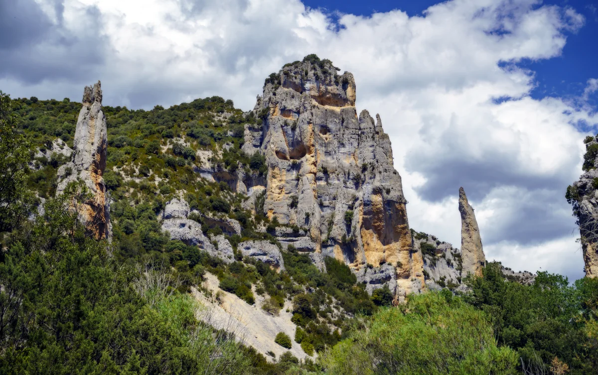
Tall pale limestone towers with hollows and narrow pinnacles rise above scrub-covered slopes beneath a blue sky and white clouds.

Limestone towers in the lower Mascún landscape near Rodellar, within Sierra y Cañones de Guara, photographed in May 2023.

PPA2827 Rodellar, dolmen de la Losa Mora, despoblado de Otín y Mascún inferior.jpg — Pedro José Ponce Asensio / Wikimedia Commons / CC BY 4.0 · Creative Commons

Walks and routes

Bierge botanical circuit

Stay beside the centre for a small-scale introduction to Mediterranean plants and rocks. The official circuit has seven interpretation stops. Allow 20–30 minutes to look closely, at your own pace.

The official catalogue identifies an adapted circuit with tactile and Braille interpretation. Ask staff about the surface and any assistance you need.


Bierge botanical circuit

La Tamara: the adapted first section

A separate outing from Bierge’s centre: follow the first 400 m of S1 to the viewpoint towards Peña Falconera, then return the same way. Allow 30–45 minutes for the return walk and interpretation stops.

The official catalogue identifies adapted surfacing and tactile/Braille interpretation, with a reserved parking space at the start. Confirm present condition and vehicle access with staff.

La Tamara: the adapted first section

S2 Pacos de Morrano y Peña Falconera

This southern-sector circuit moves from cultivated land to Scots-pine woodland and the striking rock of Peña Falconera. The official walking time is two hours; allow longer for rests and looking at the landscape. Make it the main walk of the day rather than an automatic extra.

This is a countryside walking route. Ask staff about its terrain before considering it with a wheelchair or pushchair.

S2 Pacos de Morrano y Peña Falconera

S1 Fuente de la Tamara: full walk

The full out-and-back reaches a spring beside the Alcanadre and shows how flowing water shapes different rocks. The official time is 2 hours 20 minutes, before your own picnic and nature stops. Carry enough water and keep the riverside visit on dry land.

Only the first 400 m are documented as adapted. The rest requires a separate assessment of walking ability and conditions.

S1 Fuente de la Tamara: full walk

An unhurried first visit: 1–2 hours

Arrive at Bierge during confirmed opening hours. Spend the first part indoors, ask staff what is suitable that day, and finish with the botanical circuit and a break in the recreation area. This is a flexible visit, not a timed guided programme.

A half day with a short outdoor extension

Start at the centre, then, if access and conditions suit your group, move separately to the adapted start of La Tamara. Return at its viewpoint. Leave time for travel and lunch; do not treat the full S1 as part of this short plan.

For a longer walking day

Choose either the Morrano circuit or the complete La Tamara walk, not both by default. Download the official route information, allow extra time for stops and finish well before dark. Fit the centre around its opening hours.

Things to try

A geology detective game

Use the displays to learn what a cave, sinkhole and canyon look like, then ask everyone to choose one feature they would like to understand outdoors. It makes a short visit feel purposeful without needing a strenuous route.

Birdwatching from public viewpoints

Bring binoculars and use the centre’s raptor material to compare wing and tail shapes. Watch quietly from established visitor areas; never approach nests or feed birds. Wildlife sightings depend on the day.

Adventure activities need their own plan

Climbing and canyoning have separate rules, equipment and skills. Some places have seasonal authorization requirements or year-round prohibitions. Choose the exact activity with a qualified provider and consult the park’s current guidance before committing.

Keep the day at Bierge

If the centre is open, use the geology, raptor and rural-life displays for a slower indoor visit. Do not replace a rained-off walk with a canyon descent or a river crossing.

Wildlife and habitats

Griffon vulture and golden eagle

Both are documented wild birds of the park. From established visitor areas, compare the silhouettes of birds overhead with the centre’s identification material. Keep binoculars on flying birds rather than searching nest ledges.

The bearded vulture story

The bearded vulture has a prominent place in the centre’s interpretation and is documented in the park. Make learning about it part of the visit without making a sighting the measure of a successful day.

Woodland and mammals

The Morrano route passes through Scots-pine woodland. The park also supports red fox and wild boar; learning to recognize them is worthwhile even when the animals themselves stay out of view.

Stories and discoveries

Two faces of the same mountains

The park sits between the Ebro and the Pyrenees. Its northern and southern slopes support contrasting woods, from cooler forest settings to Mediterranean evergreen-oak country.

A lived-in landscape

Terraces, pastoral buildings and dry-stone work tell part of Guara’s story. Look for the relationship between cultivated land and the surrounding woods rather than seeing the park as empty wilderness.

When to visit

Spring and autumn

Favour a measured walking day and carry layers. Check rain, river conditions and sunset time before deciding how far to go.

Summer

Choose early outdoor time, carry sufficient drinking water and use shade or the centre when available. Heat or approaching storms are good reasons to shorten a walk.

Winter

Keep ambitions flexible and ask about snow or ice on your intended route. A short low-level visit can be the better choice; verify the centre calendar before relying on indoor time.

Getting there and practical advice

Bierge visitor information

Find the centre on Carretera de Rodellar, s/n, 22144 Bierge. The official listing gives +34 974 318 238. There are exhibitions, audiovisual interpretation, visitor advice, parking and a recreation area.

Opening, entry and activities

Somontano’s official listing describes centre entry as free. Opening follows a calendar rather than guaranteed daily hours. Check the centre page before travelling, and check booking instructions for any advertised guided activity.

A practical place to pause

The official tourism listing includes a picnic area. Bring your own water and food if your day depends on them; confirm toilet access during opening hours rather than assuming facilities stay available after the centre closes.

Aim for the Bierge centre

Use the centre’s named address rather than a generic park pin. The coordinates shown here refer to that building. If visiting another sector, plan the drive and the exact trailhead separately.

Parking and onward travel

Park in marked visitor areas and obey restrictions. Do not use private land without permission or block gates and emergency access. For a car-free visit, confirm an actual outward and return service or transfer to the centre before setting out.

At the interpretation centre

The official accessibility catalogue documents two reserved parking spaces, a ramp between the two exhibition levels, adapted toilets, Braille text and a hearing loop in the audiovisual room. Contact the centre about the specific facilities you will rely on.

Choosing an outdoor option

The botanical circuit and the adapted 400 m start of La Tamara are identified separately in the official catalogue. The latter is a separate location, not a continuation from the centre garden. Confirm today’s surface, access and suitable assistance before choosing it.

Visitor information

Check before leaving

The Aragón website still lists a rockfall warning for S-4 Pasarelas del Vero as of 16 October 2026. A separate Formiga notice announces a short access closure for 14 October, but contains inconsistent date wording. If visiting that canyon, ask the park for its current status. Use the official notices and local instructions for any outing.

Sources and useful links

Wildlife you might spot

5

Each card links to a full Explore page with photos, traits, and fun facts.

Snap map for this place

Start with the big picture, then zoom in to explore individual wildlife observations around this place.

Loading map…

Good to know before you go

Check Bierge’s opening calendar before setting out; call +34 974 318 238 if your visit depends on the centre being open.

Read the current park notices. The Aragón park page, updated 16 July 2026, excludes S-4 Pasarelas del Vero from its offered trails because of rockfall risk; do not make it your default family walk.

Carry water, sun protection, suitable shoes and a warmer layer. Take a charged phone and a route map for longer outings.

Keep the 400 m adapted start of La Tamara separate from the full 9.4 km walk when choosing a route.

Use signed parking and keep access clear. On the Molino de Bierge–La Tamara track, parking is restricted to designated signed places.

Keep dogs on a lead, stay on marked paths and leave plants and rocks where they are.

No fires or wild camping. Take all litter away and keep soap and detergents out of watercourses.

For canyoning, use an appropriately qualified professional if you lack training; check water levels, weather and the rules for the specific canyon.

Frequently asked questions

Yes. Bierge’s centre and botanical circuit are the suggested first visit. Walking routes and viewpoints let you explore without entering a canyon or swimming.
The official Somontano tourism listing describes entry as free. Check the centre calendar and any separate activity booking requirements before travelling.
The official adapted section is the first 400 m, leading to a viewpoint. The complete S1 is a 9.4 km out-and-back walk and should not be treated as a wheelchair route.
Do not rely on that plan. The Aragón park page carries a rockfall warning and excludes S-4 Pasarelas del Vero from its trail offer. Seek current instructions from the park and the route operator before considering it.
Do not assume one rule covers every activity. Canyoning and climbing have location-specific restrictions, seasonal limits and, in some places, authorization requirements. Ask the park about organized events or specialist activities; check individual guided outings for booking instructions.
Treat that as a separate outing with its own municipal access arrangements. This centre-and-walking plan does not include swimming or permission to enter the water.

Recent snaps at this place

Recent snaps will appear here as new observations are added.

View all ›

Take the discovery with you

Exploring Sierra y Cañones de Guara Natural Park?

Identify the wildlife you spot, learn as you go, and keep a collection of the adventure.

  1. 1Spot it
  2. 2Snap it
  3. 3Keep the discovery













