Snappit logo
Snappit
Get App
Generic illustration, not a photograph of this venueIllustration
ParkIT

Tuscan-Emilian Apennine National Park

The pleasure here is the change of scale.

About

The pleasure here is the change of scale. In the woods, the landscape is close and sheltered; above the trees, grassy basins open towards a mountain skyline. Ice shaped the lake hollows, while generations of grazing, forestry and cultivation also left their mark. This is a lived-in Apennine landscape, with villages and working mountain huts alongside sensitive habitats. Choose one area for a day rather than trying to join every famous name into a single drive. A clear forecast matters more than collecting a summit. Take the ultimate field guide with you: use the Snappit app to identify birds, plants, and animals on your trip.

The national park was established in 2001, but its landscapes have a much longer human story. Bismantova combines prehistoric archaeology, former cultivated summit ground and a religious site below its cliffs. In upper Val Parma, beech woodland sits beside areas of silver fir planted during forestry programmes. Recognising those layers makes a walk more interesting: an apparently wild view can also be the result of long use and careful management.

What to do here

For a first visit, choose the Lagdei boardwalk if you want an undemanding nature stop, the Lagoni–Badignana circuit for a proper lake-and-mountain walk, or Bismantova for rock scenery and a hilltop plateau. Monte Prado suits walkers ready to include a substantial approach to a high mountain hut. On the Garfagnana side, Orecchiella offers a visitor-centre outing with seasonal indoor exhibits and captive-animal enclosures.

Seasonal info

A mild valley day can still mean cold wind or lingering snow higher up. Snow-covered ridge routes require a different level of equipment and judgement from their summer versions. If visibility deteriorates, shorten the day while your return remains straightforward.

Accessibility

The clearest lower-effort starting point is the approximately 400 m Lagdei peat-bog trail, described by the park as level and partly on raised wooden walkways. Its current surface condition, parking-to-trail connection and toilet access need checking with the local information point. Summit walks should not be treated as step-free alternatives.

Don't miss

1

The contrast between glacial lake basins and open mountain ridges

2

Pietra di Bismantova’s broad plateau and sheer sides

3

A small-scale wetland visit at Lagdei

4

High-level views from the Monte Prado area, in suitable conditions

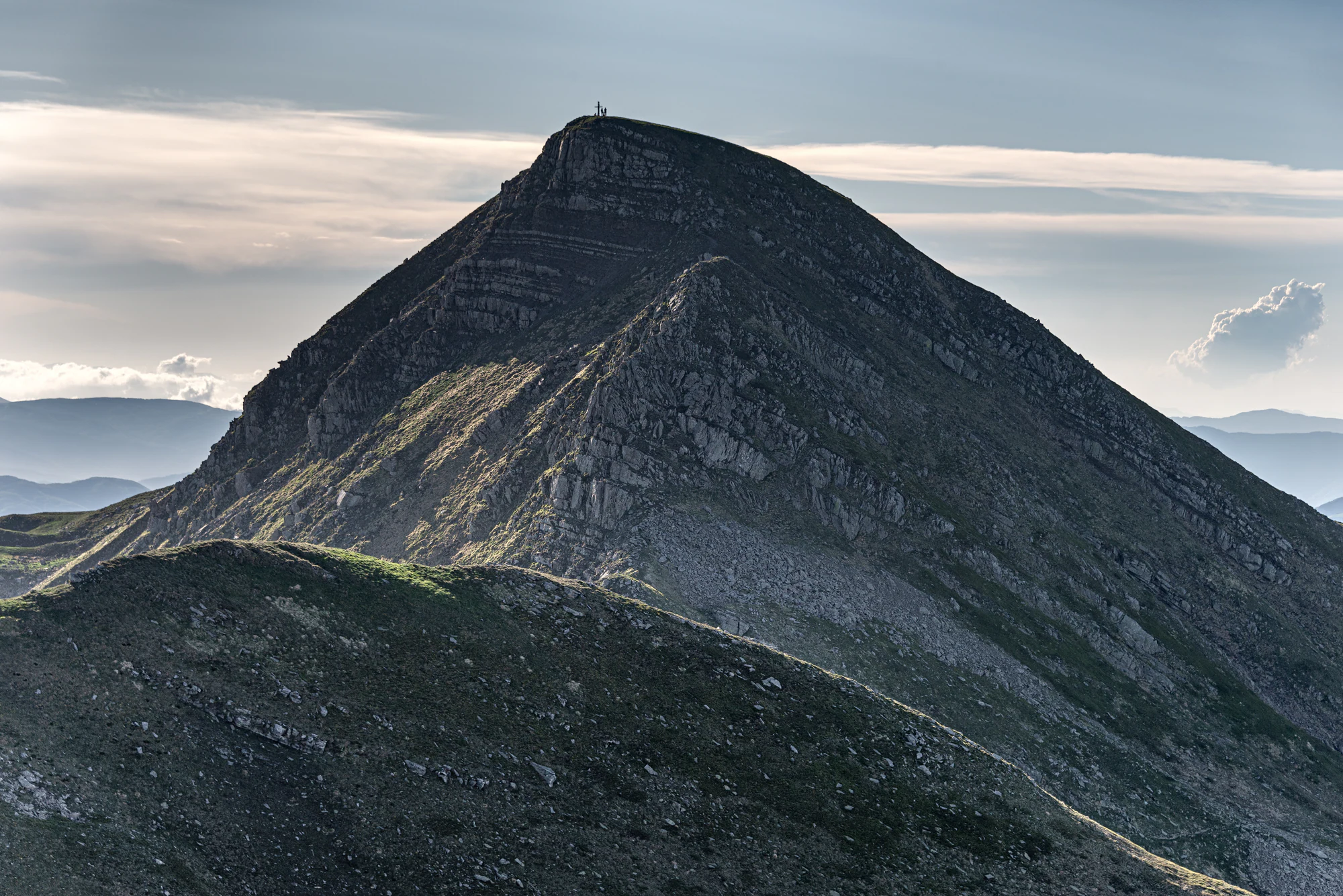
Layered rocky slopes rising to a rounded skyline, with a tiny summit cross and small human silhouettes against a cloudy sky.

Rocky ridges in the Monte Cusna area, photographed on 15 June 2019. This historical view does not show current trail or weather conditions.

“Monte Cusna - Sasso del Morto, Villa Minozzo, Reggio Emilia, Italy - June 15, 2019 01.jpg” — Giorgio Galeotti, via Wikimedia Commons. CC BY 4.0. Unmodified offered original. Copyright notice supplied: Giorgio Galeotti. · Creative Commons

Walks and routes

Lagdei: a wetland at walking pace

The park’s approximately 400 m sensory trail circles a peat bog left by an ancient glacial lake. Raised timber sections and interpretation panels make this a rewarding small outing without committing to a mountain ascent. Allow roughly 30–60 minutes to pause and read; that is a suggested visit allowance, not an official walking time. The nearby park information point is associated with Rifugio Lagdei. Official trail details.

The published route is level and designed for broad access. Ask about the condition of the boards, the approach from the parking area and accessible toilets before relying on independent wheelchair access.


Lagdei: a wetland at walking pace

Pietra di Bismantova: rock scenery and the plateau

The park’s circuit begins at Piazzale Dante and combines woodland, Campo Pianelli and the summit plateau, principally using trail 697. It publishes 280 m of ascent and 2½ hours, while the detailed timings total about three hours. Allow half a day with stops. The sandstone walls and the contrast between wooded slopes and the open top are the main rewards. Official itinerary.

Treat this as a hiking route. The older itinerary says T+, but the current register rates 697 E, or hiking. Uneven ground, steep sections and unprotected edges make it unsuitable as a step-free outing.

Pietra di Bismantova: rock scenery and the plateau

Lagoni and Valle di Badignana: a full lake circuit

Starting beside Rifugio Lagoni, the official circuit links the Badignana basin, Passo di Fugicchia and Lago Scuro before returning to the Lagoni. It publishes 3½ hours and 420 m of ascent, using trails 719, 715 and 711, with a short Lago del Bicchiere detour. Plan most of a day with a picnic and unhurried stops; leave the separate Monte Matto summit excursion out of this plan. Official itinerary.

Despite the older page’s T label, the component trails are rated E in the current register. Expect a real mountain walk with climbing, uneven paths and exposed weather, rather than a flat lakeside circuit.

Lagoni and Valle di Badignana: a full lake circuit

Monte Prado from Rifugio Bargetana

From Rifugio Bargetana, the operator describes a two-hour return walk with 310 m of ascent on trails 633, 631 and 00, passing Lago della Bargetana and the saddle below Monte Prado’s 2,054 m summit. For a shorter outing from the hut, the lake alone is listed as 40 minutes return with 60 m of ascent. These are hut-based excursions, not roadside walks. Operator’s routes.

The high route demands suitable footwear, stamina and confidence navigating in mountain weather. The lake alternative reduces the extra climbing, but reaching the hut still takes effort.

Monte Prado from Rifugio Bargetana

A flexible two-day visit

Use the first day for the outing nearest your accommodation, choosing Lagdei or Badignana according to energy and weather. Give the second day to a different landscape such as Bismantova, after allowing for the road transfer. If Prado is your priority, build the trip around its approach and a confirmed hut stay instead of adding it to this plan.

Things to try

Keep a weather backup close to your base

If exposed walking is unsuitable, ask an open visitor centre which indoor exhibits are available, or make the day a village-and-meal stop. Orecchiella’s indoor options are seasonal and the whole site can close in bad weather. Do not make a long cross-park drive simply to find a closed museum.

Wildlife and habitats

Look for habitats first

Bilberry heath, high grassland, beech woods and wetlands support very different life. Monte Prado’s protected-site account records cold-adapted plants, including the Apennine primrose. Enjoy those plant communities from the path: finding a rare flower is no reason to cross fragile ground.

Golden eagle and gray wolf

Golden eagles use open high ground for hunting and rocky places for nesting. Scan the sky from established paths with binoculars, without approaching nest cliffs. Wolves are part of the park’s wild fauna, but an encounter should never be the expectation or the purpose of baiting, calling or following an animal.

European common frog, common bilberry and silver fir

The European common frog is recorded in the park and the Monte Prado site. Leave amphibians and their water undisturbed. Common bilberry is a documented component of the high heathland; photograph it rather than assuming collecting is allowed. In upper Val Parma, the park specifically identifies silver-fir stands created by reforestation, a useful reminder that forest history is not uniform.

Stories and discoveries

A wetland is part of the glacial story

Lagdei’s peat bog and the lakes around Badignana show different outcomes of former glacial basins. Some hollows still hold open water; others have filled and developed wetland vegetation. The boardwalk makes that long landscape history visible on a very short visit.

When to visit

Spring and summer

The lower Bismantova outing has a longer published visiting season than the higher lake circuit. A hut booking does not oblige you to continue into unsuitable weather.

Autumn and winter

Beech colour and reddening bilberry heath can be an excellent reason to choose a woodland-and-lake visit in autumn. After snowfall, do not reuse summer timings as a winter itinerary. Seek current mountain-condition advice and an appropriately qualified guide if your experience does not cover snow and ice.

Getting there and practical advice

Huts: check the right operator

Rifugio Lagdei is a useful contact for its local information point and facilities. At Lagoni, follow the new operator’s website or call +39 0521 1160210: it advertises restaurant service and 19 beds in four dormitories, although the park directory still carries a closed label. Confirm dates, meals and road conditions directly. For Bargetana, overnight booking is required; its standing schedule lists daily opening from mid-June to early September and weekends in October, subject to confirmation.

Orecchiella: a family alternative in Garfagnana

The visitor centre and nature exhibits give a different kind of day from a summit walk. Its published 2026 adult ticket for the centre and museums is €2. October opening is Sundays, 10:00–17:00, with 1 November also listed; adverse weather can cause closure. Check the operator’s timetable for your date. The season announcement did not confirm the Museo del Territorio’s reopening, so ask which exhibits are actually available.

By road: choose the valley before setting off

The main approach roads follow valleys and cross the ridge, so neighbouring names on a map can mean separate outings. Use Castelnovo ne’ Monti for Bismantova, Bosco di Corniglio for the Lagdei/Lagoni sector, and Ligonchio for the Presa Alta approach to Bargetana. The Lagoni operator describes the final 4.5 km from Cancelli as a forest road. Check its condition before committing a vehicle, and obey barriers and authorised parking signs.

Without a car

The park identifies Parma and Reggio Emilia as rail gateways on the Emilian side and Castelnuovo di Garfagnana on the Tuscan side. Build the onward journey with TEP for Parma, the SETA Reggio network and Autolinee Toscane for Garfagnana. Confirm the actual date, stop and last return, especially on Sundays. Arrange the final trailhead transfer in advance if the bus leaves you in a valley settlement.

Ask practical questions, not just whether a route is “easy”

For a wheelchair or mobility aid, establish the usable path length, surface, gradients at its approach, resting places and toilet arrangements. A published accessible design is a helpful starting point, but it is not an inspection of today’s boards or a guarantee that every connecting path works for your needs.

Clean boots between walks

The park’s African swine fever advice asks walkers to clean and disinfect footwear and avoid touching wild-boar remains. Follow current local veterinary instructions, report a carcass rather than approaching it, and check for any access measures affecting your chosen area. Do not assume that an older general notice defines today’s restricted zones.

Sources and useful links

Wildlife you might spot

5

Each card links to a full Explore page with photos, traits, and fun facts.

Snap map for this place

Start with the big picture, then zoom in to explore individual wildlife observations around this place.

Loading map…

Good to know before you go

Save the official route information and a suitable walking map before leaving your accommodation. Trail numbers alone do not describe every junction or hazard.

Carry your own drinking water, food, waterproof layer and warm clothing. Do not make the day depend on an unconfirmed hut meal or a working spring.

Keep children well back from Bismantova’s cliff edges. Its summit is a walking destination, but the drop-offs are real.

Stay on established paths around peat bogs and lake margins. Leave flowers and wildlife undisturbed; the park prohibits collecting protected plants.

Check the exact road, parking point and return transport for your chosen area. A village bus stop is not necessarily close to a mountain trailhead.

Frequently asked questions

Choose by effort and starting point. Lagdei is the strongest choice for a short, level nature visit; Badignana is a longer walking day; Bismantova offers a different rock landscape. Save Prado for a day when you can accommodate the hut approach as well as the summit walk.
The published two-hour return starts at Rifugio Bargetana, already high in the mountains. It does not include reaching the hut from a road. Add the approach in both directions, or book a hut night and split the effort.
Do not treat it as an ordinary extension of a Lagdei walk. The park’s October 2026 visit notice says entry is in a group accompanied by the Carabinieri Forestali. Check the current programme and reservation arrangements for an authorised visit.
The bears advertised for visitors are in enclosures. Seeing them is a captive-animal experience and does not establish a wild bear population in this national park.
Check your exact route and attraction before setting out, and keep your dog under close control around wildlife and grazing animals. Orecchiella’s 2026 visitor information explicitly excludes dogs from its paid reserve area. Do not assume one site’s rule applies everywhere.
Plan costs around the particular service you will use. Orecchiella charges for its visitor centre and museums; accommodation, guided activities and other services have their own arrangements. Check parking charges and any local access controls separately rather than relying on a single park-wide price.

Recent snaps at this place

Recent snaps will appear here as new observations are added.

View all ›

Take the discovery with you

Exploring Tuscan-Emilian Apennine National Park?

Identify the wildlife you spot, learn as you go, and keep a collection of the adventure.

  1. 1Spot it
  2. 2Snap it
  3. 3Keep the discovery