Snappit logo
Snappit
Get App
Generic illustration, not a photograph of this venueIllustration
ParkAuvergne-Rhône-Alpes, FR

Vanoise National Park

Vanoise is a mountain national park in Savoie, between the Maurienne and Tarentaise valleys.

About

Vanoise is a mountain national park in Savoie, between the Maurienne and Tarentaise valleys. Its protected core reaches the Grande Casse, at 3,855 metres, but a first visit need not involve a pass or a glacier. The Orgère gateway lets a family explore one valley at a manageable pace.

Open meadows reflect generations of farming; nearby, large conifers and fallen wood reveal a forest developing at its own pace. Looking between them gives children a useful question to investigate: which parts of this scene depend on people, and which change when people step back?

The park’s concern for wildlife and mountain ways of life is visible in working pastures and seasonal refuges. Give yourself time for a few discoveries: an interpretation station, a distant marmot or the pattern of a tree’s branches. Planning to visit? Download the Snappit app to identify the wildlife you spot in real-time.

Created on 6 July 1963, Vanoise was France’s first national park. Saving Alpine ibex was a central impetus, alongside protecting high-mountain scenery and local communities. L’Orgère offers a smaller-scale version of that story: farmland and forest share the valley, while the refuge and interpretation trail help people understand it.

What to do here

Explore the Orgère interpretation trail’s tactile models, listening stations and benches, then return along the adapted track. Experienced walkers can choose the full forest circuit. A meal at the refuge can round off the outing when it is open; arrange it separately.

Seasonal info

Autumn brings possible golden larches, frost and reduced services. In winter or with lingering spring snow, this summer plan no longer applies. Do not cross snowfields or improvise a snowshoe version.

Accessibility

The adapted out-and-back is designed for visitors with reduced mobility and pushchairs, with visual, sound and tactile interpretation. The complete circuit continues onto mountain paths. Confirm the current surface, stations, toilets and required assistance before travelling.

Don't miss

1

A mountain gateway reached by road when seasonal access permits

2

Interpretation that can be explored by touch, sight and sound

3

Hay meadows beside a centuries-old conifer forest

4

A choice between an adaptable short visit and a full walking circuit

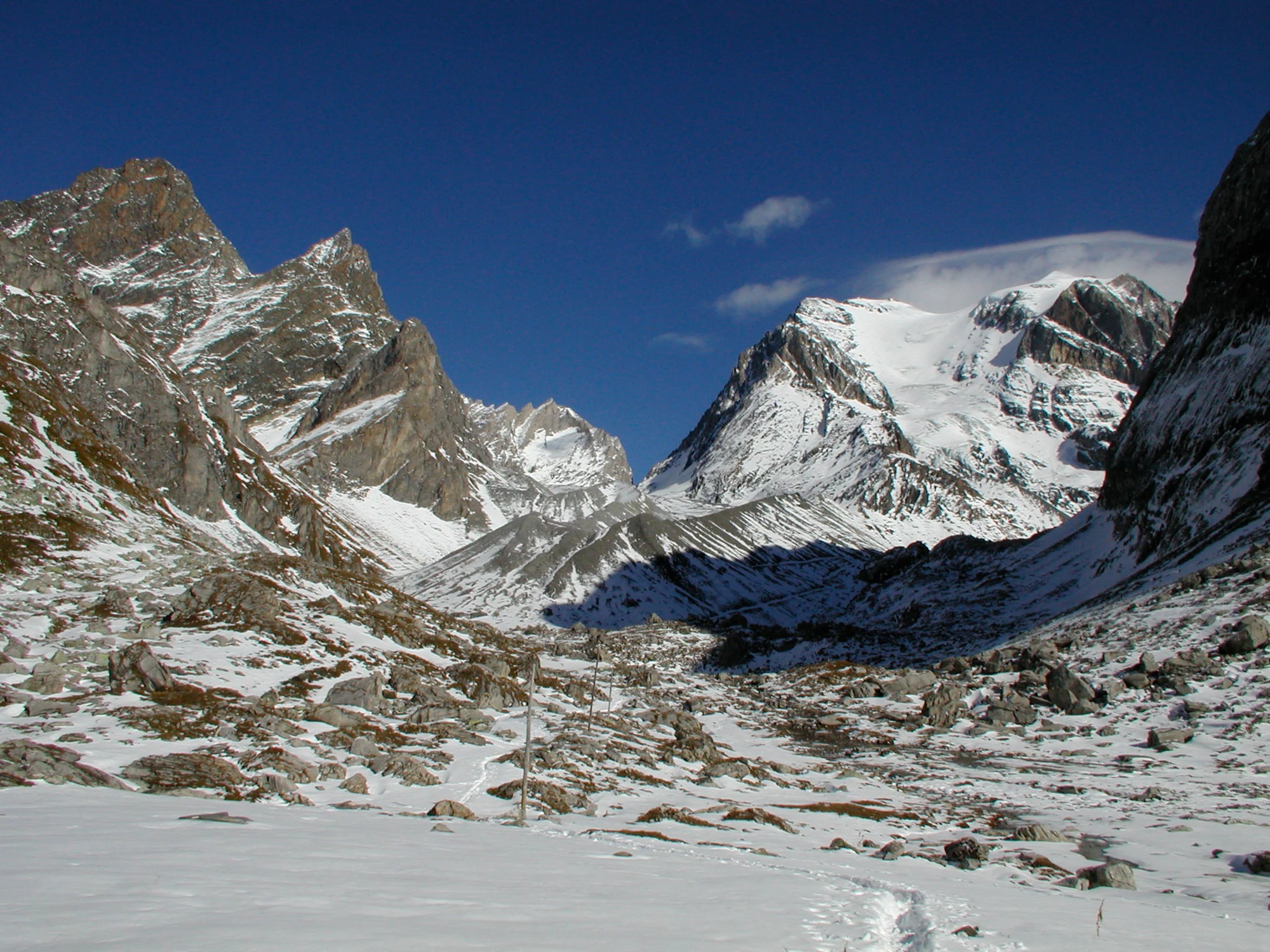
Snow covers a rocky Alpine basin below jagged ridges and a broad snowy mountain face under a deep blue sky; thin poles and tracks cross the foreground.

Snow-covered mountains toward the Grande Casse in Vanoise, photographed on 1 October 2002. This historical image does not show the Orgère family trail or present-day ice and snow conditions.

“Looking towards La Grande Casse, in the Vanoise National Park, France.” — Richard Allaway, CC BY 2.0. Source: https://www.flickr.com/photos/geographyalltheway_photos/6341518994/. License: https://creativecommons.org/licenses/by/2.0/. Original photograph, unchanged. · Creative Commons

Walks and routes

Orgère interpretation trail: the short option

Start at the Orgère car park just beyond the refuge. Take the former EDF track and follow the marked discovery trail and its interpretation stations. The adapted section ends after the concrete bridge over the Povaret, below the Aiguille Doran; return the same way. Turn back earlier if that suits your group. Allow 1–2 hours including stops, rather than aiming to finish every station.

Keep to the adapted track throughout. Do not follow the continuing forest-loop path with a wheelchair or pushchair. Ask the refuge or park team to confirm the precise endpoint and current usability before setting out.


Orgère interpretation trail: the short option

Vallon de l’Orgère: the complete walking loop

For walkers comfortable on mountain paths, the full marked circuit continues beyond the adapted section, crosses the Masse by footbridge and climbs before descending through the forest. Follow the official route through the chalet area and back to the starting car park. Published route: 4.3 km, 197 m ascent and 3 hours 30 minutes. Take the current official description with you; the short option above is the default family recommendation.

This is a walking circuit with climbing, descending and uneven ground. The accessible designation applies to its initial section, not to the whole loop.

Vallon de l’Orgère: the complete walking loop

A relaxed half-day with younger children

Arrive with your return transport settled, check the local notices, and choose the short trail. Spend time at two or three stations rather than rushing through all of them. Pause for a snack at an appropriate stopping place, return the same way and, if arranged, finish at the refuge.

Things to try

Read the meadow as a working landscape

From the path, look for the boundaries between open grassland, old buildings and woodland. Ask each person to pick something that suggests human work, then compare explanations at the next interpretation station. Resist the temptation to spread a picnic blanket in a hay meadow: the grass is part of someone’s livelihood.

Make a two-scale mountain sketch

Draw the big outline first: ridge, valley and forest. Add one small detail, such as bark texture or a branch’s shape. Putting both on the page makes a souvenir and gives younger visitors an activity that does not depend on spotting an animal.

Ask about the refuge’s discovery games

When the refuge is staffed, ask whether its nature-discovery games are available. They can give a group a new question to pursue after the walk. Also check the current programme for ranger-led activities; an event advertised in a previous summer is not a standing appointment.

Change the plan before the climb

For persistent rain, strong wind or thunderstorms, stay in the valley and ask the Modane tourist-information or park-information team for an open indoor option. During confirmed staffed hours, a refuge meal and its indoor games may suit light-rain plans, but do not make the drive in hazardous weather just to reach shelter.

Wildlife and habitats

Alpine marmot

Look over the open meadow from the path, giving a still shape time to reveal movement. A marmot may notice you first and whistle an alarm. These burrowing rodents are a summer-season possibility, not a winter attraction. Never offer food, approach a burrow or ask children to chase one for a closer photograph.

European larch

Larch changes dramatically through the year. The Orgère forest mixes it with Swiss stone pine, and autumn colours help distinguish the trees. Compare them using the interpretation material without pulling off needles or cones.

Alpine ibex

The ibex connects your visit with the park’s founding story and continuing research into environmental change. Learn its outline and curved horns before your trip, but keep it as a park-wide interest; do not follow an animal up steep slopes.

Stories and discoveries

A forest studied by leaving much of it alone

The park, the commune and the Office national des forêts work together on the Orgère forest observatory. The forest has not been commercially logged since 1943, and scientists follow how its structure and biodiversity develop. Dead wood is part of that story, providing habitat rather than simply indicating neglect.

A bird helps plant the forest

The local interpretation describes spotted nutcrackers opening Swiss stone-pine cones and hiding seeds. Forgotten stores can germinate. It is a useful connection to look for between a tree and a bird, even if you only hear a rough call or find a worked cone beside the path. Leave the cone in place.

A landscape with a farming memory

The name Orgère recalls barley cultivation. Earlier families cleared and worked the easier ground, gathering stones from their plots into piles. The open valley is therefore not simply the opposite of a natural forest: it carries another history, written in the shape of the fields and buildings.

When to visit

Early and high summer

Check lingering snow and bridges early in the season. Later, plan around the mountain forecast. If storms are forecast, postpone; trees do not make a forest route a safe lightning shelter.

Autumn

Choose the visit for forest colour only while road access, daylight and footing still suit your group. Outside the protected core, hunting can take place in the Orgère forest. Ask locally about activity on the chosen day and follow temporary signs; the national-park name does not make every nearby path hunting-free.

Winter and snow-covered periods

Choose valley-based activities when snow or ice covers this route. Road closure, refuge-room availability and mountain safety are separate questions; an open winter room would not make the route suitable for an unprepared family.

Getting there and practical advice

The refuge in its staffed season

The refuge lists food service, drinking water, toilets and indoor facilities during its staffed season, generally June to September. Confirm opening and any meal booking directly. Carry what you need for the walk regardless, and check payment arrangements before ordering; the published service list says bank cards are not accepted.

A specific off-season closure to check

A refuge notice dated 21 September 2026 says the winter room will become accessible only once the RD106 closes. It also announces closure from 23 December to 3 January inclusive. Do not assume the room is available just because the summer season has ended; check the latest notice before planning any visit around it.

By road from the Maurienne

Use the signed RD106 approach to the Orgère refuge from the Modane area, and the designated car park beyond it. The upper road is seasonal. Check Savoie Route and local advice before driving up, respect road barriers and park without blocking access. A navigation app displaying a route does not establish that it is open.

By train and seasonal bus

Modane is the rail gateway. The official summer 2026 guide lists Line 1 between Modane and Orgère, operating daily from 1 July to 31 August 2026. Those dates have passed and do not establish the next season’s service. For a future visit, check the current timetable, return journey, booking and wheelchair arrangements. Walking up from the station is a separate, much longer undertaking.

Plan the whole journey, not just the path

Ask about the parking-to-trail connection, toilet access and whether any equipment needs booking. Explain your actual mobility needs, including whether someone can assist on a slope. If travelling by bus, confirm the vehicle as well as the stop: accessible interpretation on site does not guarantee an accessible transport connection.

Sources and useful links

Wildlife you might spot

3

Each card links to a full Explore page with photos, traits, and fun facts.

Snap map for this place

Start with the big picture, then zoom in to explore individual wildlife observations around this place.

Loading map…

Good to know before you go

Carry drinking water, a snack, sun protection, warm layers and waterproofs, even for the short visit. Stream water is not a dependable drinking supply.

Download the official route before leaving the valley and tell someone your plan. Phone reception may be patchy in the mountains.

Keep binoculars handy. Let wildlife carry on with its day, and move away if an animal stops feeding or watches you persistently.

Leave flowers, cones, stones and fallen wood where they are. A photograph or drawing makes a better record of the visit.

Keep the return journey in mind before starting: check your last bus or leave enough daylight for the drive down.

In the protected core, leave drones at home, light no fires and do not camp freely. Overnight bivouacs are restricted to designated arrangements near certain refuges and require booking.

Frequently asked questions

Choose the short out-and-back in dry, snow-free conditions and set the turnaround according to the least confident person. Decide on the full circuit before starting; an easy first section can otherwise lead to an unexpectedly demanding day.
Ibex live in Vanoise, but a sighting from this path is never assured. The meadows and forest make a worthwhile visit even without a large-animal encounter.
The Orgère route largely follows the edge of the protected core, and its route advice recommends a lead. This does not permit entering the core with a pet dog: pets are prohibited there, including on a lead, with specific exceptions such as assistance dogs. Check the exact itinerary and boundary signs before setting out.
No admission booking is advertised for the self-guided trail. Budget separately for transport, food, accommodation and booked activities, checking their current charges before travelling.

Recent snaps at this place

Recent snaps will appear here as new observations are added.

View all ›

Take the discovery with you

Exploring Vanoise National Park?

Identify the wildlife you spot, learn as you go, and keep a collection of the adventure.

  1. 1Spot it
  2. 2Snap it
  3. 3Keep the discovery